Polish regions are regions that are in present-day Poland but are not identified in its administrative division.
Contents

Polish regions are regions that are in present-day Poland but are not identified in its administrative division.
(Transborder regions = *)
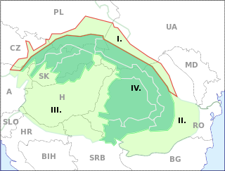
Outer Subcarpathia denotes the depression area at the outer base of the Carpathian arc, including foothills of the Outer Western Carpathians and Outer Eastern Carpathians. It stretches from northeastern Austria, through eastern Czech Republic, southern Poland, western Ukraine and northeastern Romania.

The Beskids or Beskid Mountains are a series of mountain ranges in the Carpathians, stretching from the Czech Republic in the west along the border of Poland with Slovakia up to Ukraine in the east.

Divisions of the Carpathians are a categorization of the Carpathian mountains system.
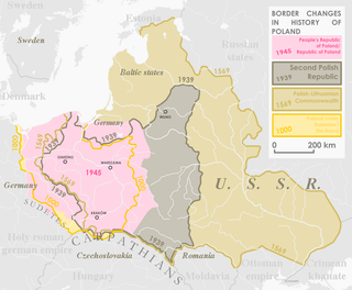
Western Borderlands is a term used to refer to the western parts of the Polish–Lithuanian Commonwealth that in the partitions were annexed by Prussia. This name refers specifically to the regions of Eastern Pomerania, Greater Poland, Warmia, and occasionally Upper Silesia.
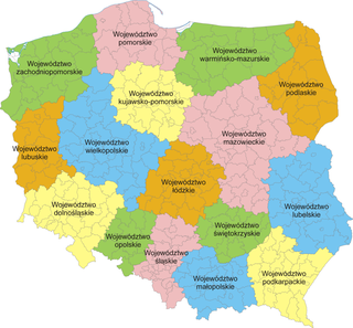
The administrative division of Poland since 1999 has been based on three levels of subdivision. The territory of Poland is divided into voivodeships (provinces); these are further divided into powiats, and these in turn are divided into gminas. Major cities normally have the status of both gmina and powiat. Poland currently has 16 voivodeships, 380 powiats, and 2,478 gminas.
IV liga is the fifth level of the Polish football league system. The current structure of IV liga was created in the 2000–01 season after introducing the new administrative division of Poland. Groups consists most often of 18 clubs, which each group winner earning promotion to III liga. The bottom clubs are relegated to Liga okręgowa or V liga.

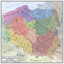
Polish historic regions are regions that were related to a former Polish state, or are within present-day Poland, with or without being identified in its administrative divisions.
Kolonia Bogoria is a village in the administrative district of Gmina Bogoria, within Staszów County, Świętokrzyskie Voivodeship, in south-central Poland. It lies approximately 4 kilometres (2 mi) south-west of Bogoria, 9 km (6 mi) north-east of Staszów, and 52 km (32 mi) south-east of the regional capital Kielce.
Kolonia Pęcławice is a village in the administrative district of Gmina Bogoria, within Staszów County, Świętokrzyskie Voivodeship, in south-central Poland. It lies approximately 3 kilometres (2 mi) east of Bogoria, 13 km (8 mi) north-east of Staszów, and 55 km (34 mi) south-east of the regional capital Kielce.
Kolonia Wysoki Małe is a village in the administrative district of Gmina Bogoria, within Staszów County, Świętokrzyskie Voivodeship, in south-central Poland. It lies approximately 4 kilometres (2 mi) north-east of Bogoria, 15 km (9 mi) north-east of Staszów, and 54 km (34 mi) south-east of the regional capital Kielce.
Malkowice is a village in the administrative district of Gmina Bogoria, within Staszów County, Świętokrzyskie Voivodeship, in south-central Poland. It lies approximately 5 kilometres (3 mi) north-west of Bogoria, 13 km (8 mi) north of Staszów, and 48 km (30 mi) south-east of the regional capital Kielce.
Tursko Małe-Kolonia is a colony in the administrative district of Gmina Połaniec, within Staszów County, Świętokrzyskie Voivodeship, in south-central Poland. It lies approximately 6 kilometres (4 mi) east of Połaniec, 19 km (12 mi) south-east of Staszów, and 72 km (45 mi) south-east of the regional capital Kielce.
Zdzieci Nowe is a colony in the administrative district of Gmina Połaniec, within Staszów County, Świętokrzyskie Voivodeship, in south-central Poland. It lies approximately 5 kilometres (3 mi) west of Połaniec, 15 km (9 mi) south of Staszów, and 66 km (41 mi) south-east of the regional capital Kielce.
Zdzieci Stare is a village in the administrative district of Gmina Połaniec, within Staszów County, Świętokrzyskie Voivodeship, in south-central Poland. It lies approximately 4 kilometres (2 mi) west of Połaniec, 17 km (11 mi) south of Staszów, and 68 km (42 mi) south-east of the regional capital Kielce.
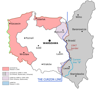
The Recovered Territories or Regained Lands, also known as the Western Borderlands, and previously as the Western and Northern Territories, Postulated Territories and Returning Territories, are the former eastern territories of Germany and the Free City of Danzig that became part of Poland after World War II, at which time most of their German inhabitants were forcibly deported.

The Western Beskids are a set of mountain ranges spanning the Czech Republic, Slovakia, and Poland. Geologically the Western Beskids are part of the Outer Western Carpathians.

National costumes of Poland vary by region. They are typically not worn in daily life but at folk festivals, folk weddings, religious holidays, harvest festivals and other special occasions. The costumes may reflect region and sometimes social or marital status.
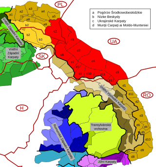
The Eastern Beskids or Eastern Beskyds are a geological group of mountain ranges of the Beskids, within the Outer Eastern Carpathians. As a continuation of the Central Beskids, this mountain range includes the far southeastern corner of Poland, the far eastern corner of Slovakia, and stretches southward through western parts of Ukraine, up to the border of Romania.

The Masurian District, also known as the District of East Prussia, and designated as the 4th District, was a district that acted as an provisional administrative division of Poland, during the administration of the Provisional Government of the Republic of Poland in 1945, and the Provisional Government of National Unity from 1945 to 1946. It was centered around the areas of Masuria, Powiśle and Warmia. It was established as one of four provisional districts on 14 March 1945. On 25 September 1945, areas near its western border were incorporated into the Gdańsk Voivodeship, while the areas near its eastern border, to the Białystok Voivodeship. It existed until 28 June 1946, when it was abolished and replaced with the Olsztyn Voivodeship. The head of the district was the attorney-in-fact Stanisław Piaskowski.
Poland articles | |||||||||
|---|---|---|---|---|---|---|---|---|---|
| History |
|  | |||||||
| Geography | |||||||||
| Politics | |||||||||
| Economy | |||||||||
| Society |
| ||||||||
| | This Poland location article is a stub. You can help Wikipedia by expanding it. |