River system
 |
Following is a list of rivers, which are at least partially, if not predominantly located within Poland. [1] [2]
For list of rivers in alphabetical order, please use table-sort buttons.
| River name | Emptying into | Total length (in km) | Length in Poland (in km) | Total basin area (in km2) | Basin area in Poland (in km2) |
|---|---|---|---|---|---|
| Vistula | Baltic Sea | 1022 | 1022 | 193,690 | 168,868 |
| Oder | Baltic Sea | 840 | 726 | 119,074 | 106,043 |
| Warta | Oder | 795 | 795 | 54,520 | 54,520 |
| Bug | Narew | 774 | 590 | 38,712 | 19,239 |
| Narew | Vistula | 499 | 443 | 74,527 | 53,846 |
| San | Vistula | 458 | 457 | 16,877 | 14,426 |
| Noteć | Warta | 391 | 391 | 17,302 | 17,302 |
| Wieprz | Vistula | 349 | 349 | 10,497 | 10,497 |
| Pilica | Vistula | 333 | 333 | 9,258 | 9,258 |
| Bóbr | Oder | 279 | 276 | 5,874 | 5,830 |
| Łyna | Pregolya | 264 | 207 | 7,126 | 5,298 |
| Wkra | Narew | 255 | 255 | 5,348 | 5,348 |
| Dunajec | Vistula | 249 | 249 | 6,796 | 4,838 |
| Nysa Łużycka | Oder | 246 | 197 | 4,403 | 2,201 |
| Brda | Vistula | 245 | 245 | 4,665 | 4,665 |
| Drwęca | Vistula | 231 | 231 | 5,697 | 5,697 |
| Prosna | Warta | 227 | 227 | 4,917 | 4,917 |
| Wisłok | San | 220 | 220 | 3,538 | 3,538 |
| Wda (Czarna Woda) | Vistula | 198 | 198 | 2,325 | 2,325 |
| Drawa | Noteć | 192 | 192 | 3,291 | 3,291 |
| Nysa Kłodzka | Oder | 189 | 189 | 4,570 | 3,742 |
| Rega | Baltic Sea | 188 | 188 | 2,767 | 2,767 |
| Bzura | Vistula | 173 | 173 | 7,764 | 7,764 |
| Wisłoka | Vistula | 173 | 173 | 4,100 | 4,100 |
| Obra | Warta | 171 | 171 | 2,760 | 2,760 |
| Pasłęka | Vistula Bay, Baltic Sea | 169 | 169 | 2,294 | 2,294 |
| Biebrza | Narew | 164 | 164 | 7,092 | 7,067 |
| Nida | Vistula | 154 | 154 | 3,844 | 3,844 |
 |

Lubusz Voivodeship, or Lubuskie Province is a voivodeship (province) in western Poland.

Pomeranian Voivodeship, Pomorskie Region, or Pomerania Province (Polish: Województwo pomorskie ;, is a voivodeship, or province, in northwestern Poland. The provincial capital is Gdańsk.

Świętokrzyskie Voivodeship, Świętokrzyskie Province, literally in English Holy Cross Voivodeship is one of the 16 voivodeships (provinces) into which Poland is divided. It is situated in southeastern Poland, in the historical region of Lesser Poland, and takes its name from the Świętokrzyskie mountain range. Its capital and largest city is Kielce.

Subcarpathian Voivodeship or Subcarpathia Province is a voivodeship, or province, in the southeastern corner of Poland. Its administrative capital and largest city is Rzeszów. Along with the Marshall, it is governed by the Subcarpathian Regional Assembly. Historically, most of the province's territory was part of the Kingdom of Galicia–Volhynia, the Kingdom of Galicia and Lodomeria and the Ruthenian Voivodeship. In the interwar period, it was part of the Lwów Voivodeship.
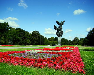
Łękno, officially known as Łekno, and until 1945 as Westend, is a municipal neighborhood of the city of Szczecin, Poland, situated on the left bank of Oder river, north-west of the districts of Stare Miasto and Śródmieście. In 2020, it was inhabited by 3065 people.

Hrčava (help·info) is a village in Frýdek-Místek District, Moravian-Silesian Region, Czech Republic. It is the second easternmost village of the country, lying near the borders with Poland and Slovakia. In 2001 census six people declared Polish nationality and 96.7% declared Roman Catholic faith.
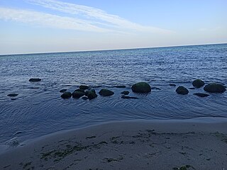
Cape Rozewie is a headland on the Baltic coast of Poland, in Pomeranian Voivodeship, close to the village of Rozewie. It was formerly thought to be the most northerly point in Poland, but since measurements carried out in December 2000, that distinction is now given to a nearby beach in Jastrzębia Góra, marked by the "Northern Star" obelisk on the clifftop. Rozewie is site of a lighthouse and a nature reserve.

Kurozwęki is a village in the district of Gmina Staszów, within Staszów County, Świętokrzyskie Voivodeship, in south-central Poland. It lies on the Czarna Staszowska river, in the historic province of Lesser Poland, approximately 6 kilometres (4 mi) north-west of Staszów and 48 km (30 mi) south-east of the regional capital Kielce.
Ceber is a village in the administrative district of Gmina Bogoria, within Staszów County, Świętokrzyskie Voivodeship, in south-central Poland. It lies approximately 5 kilometres (3 mi) north-west of Bogoria, 15 km (9 mi) north of Staszów, and 48 km (30 mi) south-east of the regional capital Kielce.
Kolonia Bogoria is a village in the administrative district of Gmina Bogoria, within Staszów County, Świętokrzyskie Voivodeship, in south-central Poland. It lies approximately 4 kilometres (2 mi) south-west of Bogoria, 9 km (6 mi) north-east of Staszów, and 52 km (32 mi) south-east of the regional capital Kielce.
Zagorzyce is a village in the administrative district of Gmina Bogoria, within Staszów County, Świętokrzyskie Voivodeship, in south-central Poland. It lies approximately 5 kilometres (3 mi) east of Bogoria, 16 km (10 mi) north-east of Staszów, and 56 km (35 mi) south-east of the regional capital Kielce.
Wymysłów is a village in the administrative district of Gmina Połaniec, within Staszów County, Świętokrzyskie Voivodeship, in south-central Poland. It lies approximately 4 kilometres (2 mi) north-west of Połaniec, 14 km (9 mi) south-east of Staszów, and 66 km (41 mi) south-east of the regional capital Kielce.
Zdzieci Nowe is a colony in the administrative district of Gmina Połaniec, within Staszów County, Świętokrzyskie Voivodeship, in south-central Poland. It lies approximately 5 kilometres (3 mi) west of Połaniec, 15 km (9 mi) south of Staszów, and 66 km (41 mi) south-east of the regional capital Kielce.
Zdzieci Stare is a village in the administrative district of Gmina Połaniec, within Staszów County, Świętokrzyskie Voivodeship, in south-central Poland. It lies approximately 4 kilometres (2 mi) west of Połaniec, 17 km (11 mi) south of Staszów, and 68 km (42 mi) south-east of the regional capital Kielce.
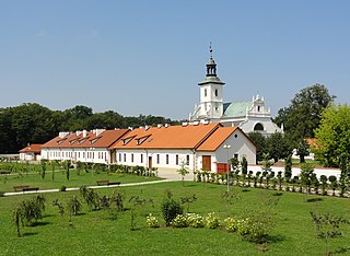
Rytwiany is a village in Staszów County, Świętokrzyskie Voivodeship, in south-central Poland. It is the seat of the gmina called Gmina Rytwiany. It lies on the Czarna Staszowska river, approximately 5 kilometres (3 mi) south-east of Staszów and 58 km (36 mi) south-east of the regional capital Kielce. The village has a population of 1,827.
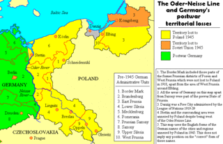
The Commission for the Determination of Place Names was a commission of the Polish Department of Public Administration, founded in January 1946. Its mission was the establishment of toponyms for places, villages, towns and cities in the former eastern territories of Germany.

Stanisław Kozierowski was a Polish Catholic priest and historian.

Dzierzbia is a small river in north-eastern Poland, flowing within the administrative district of Gmina Stawiski in Kolno County, Podlaskie Voivodeship. It is being fed by several local streams. Dzierzbia is a right-tributary of another small river called Skroda, which begins near the village of Andrychy and empties into Pisa river near the town of Rudka-Skroda.
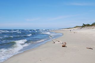
Nowa Karczma is a neighborhood of Krynica Morska on the Vistula Spit in northern Poland, located in the eastern part of the town.

Dobrzynka - is a river in Poland with an approximate length of 25.5 km.