This is a list of rivers of Bosnia and Herzegovina ordered alphabetically.
This is a list of rivers of Bosnia and Herzegovina ordered alphabetically.
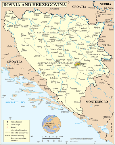
Bosnia and Herzegovina is located in Southeastern Europe. Situated in the western Balkans, it has a 932 km (579 mi) border with Croatia to the north and southwest, a 357 km (222 mi) border with Serbia to the east, and a 249 km (155 mi) border with Montenegro to the southeast. It borders the Adriatic Sea along its 20 km (12 mi) coastline.

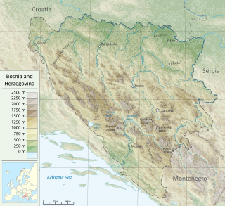
The Bosna is the third longest river in Bosnia and Herzegovina, and is considered one of the country's three major internal rivers, along with the Neretva and the Vrbas. The other three major rivers of Bosnia and Herzegovina are the Una, to the northwest; the Sava, to the north, and the Drina, to the east. This river is the namesake of Bosnia. The river Bosna flows for 282 kilometers (175 mi).

The Vrbas is a major river with a length of 250 kilometres (160 mi), in western Bosnia and Herzegovina. It is a right tributary of the Sava river. The city of Banja Luka is located on the river banks.
Bistrica or Bistrice, from Proto-Slavic *bystrъ 'quickly flowing, rushing', may refer to:

Novi Grad, formerly Bosanski Novi, is a town and municipality in Bosnia and Herzegovina. Administratively, it is located in the Republika Srpska entity. Situated in the far northwest of the country, it lies across the Una from the Croatian town of Dvor. According to the 2013 census, the town has a population of 11,063 while its municipality comprises a total of 27,115 inhabitants.
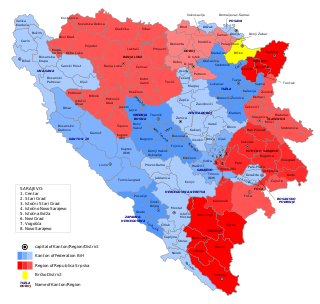
In Bosnia and Herzegovina, the smallest administrative unit is the municipality. Prior to the 1992–95 Bosnian War there were 109 municipalities in what was then Socialist Republic of Bosnia and Herzegovina. Ten of these formed the area of the capital Sarajevo.

The Jasenica is a river in central Serbia. It is 79 kilometres (49 mi) long and is the left tributary of the Great Morava. This river gives the name to the surrounding region.
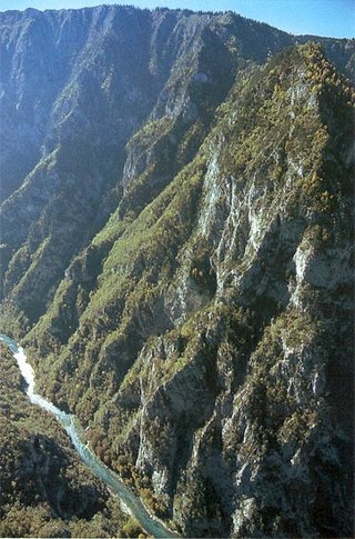
The Tara River Canyon, also known as the Tara River Gorge, is the river canyon of the Tara river. It is for the most part located in Montenegro, and to a smaller extent in Bosnia and Herzegovina. The most attractive part of the canyon are the high rocks of the mountain range of Ljubišnja, which are located in the UNESCO World Heritage Site of Durmitor National Park.

The Drina is a 346 km (215 mi) long river in the Balkans, which forms a large portion of the border between Bosnia and Herzegovina and Serbia. It is the longest tributary of the Sava River and the longest karst river in the Dinaric Alps which belongs to the Danube River drainage basin. Its name is derived from the Roman name of the river which in turn is derived from Greek.

The Crni Timok, also known as Crna River or Krivovirski Timok, is a headwater of the Timok River.

Ilomska is right tributary of the Ugar river in (Bosnia). It is about 20 kilometres (12 mi) in length, and its source is Vlašić Mountain. It is an essential body of water for surrounding wildlife. Ilomska flows between the Žežnička Greda and Javorak mountains. It has a curved flow around Lisina and Runjavica mountains, through coniferous and mixed spruce-beech woods.

The Vrbanja is a river in Central Bosnia, Bosnia and Herzegovina; with Ugar, the largest right tributary of the Vrbas. Its basin covers an area of approximately 703.5 km2. The Vrbanja has significant hydropower potential. There are many different estimations of the Vrbanja's length, from 70.5 km and 84 km to 95.4 km.
The Bila river is the largest tributary of the Lašva river. The Bila river flows past the settlements of Stara Bila and Nova Bila, with a length of approximately 35 km. Originating from Vlašić mountain, in the area of Prelivode and Meupić mountain, it flows south to south-east toward Lašva valley where it spills into the Lašva river.
Petrovo Polje is a village in Central Bosnia, Bosnia and Herzegovina, the Republika Srpska, Kneževo Municipality. Until the 1960s it belonged to the former municipality Šiprage, and then for some time and the municipality of Kotor Varoš. From ancient times to the fall of the Kingdom of Yugoslavia, the village belonged to the Church municipality Imljani.
Mala Ilomska is very short right tributary of Ilomska – one of right tributaries of Ugar − in Central Bosnia, Bosnia and Herzegovina, Skender Vakuf Municipality. This small river is formed from seven springs and streams at the Petrovo field, on the southwestern slopes of the hill Omarike. The min source is at an altitude of about 1230 m, and one of the registered is Bijeljino spring, near the hamlet of Nikodinovići. In addition to these, there are no significant tributaries.
Crna River is the only larger left tributary of Ilomska River. It originating from Duboki jarak, altitude of 1380 m, below the hill Blatnica Hill. In upper waterflow it goes to south-east, between Omanjača and the Ravan on Runjavica, above the eponymous village (Blatnica). After leaving the ravine, the river flows around Jove masiff turn right to the north to the mouth. During the Austro-Hungarian rule, along the Crna River built forest narrow-gauge railway to the turntables in 1178 for the exploitation of forest resources, which turnstile at this place as always abounds. Even today there performs intensive felling spruce and fir trees.
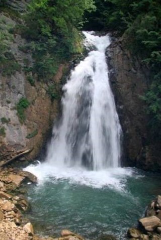
Ilomska Waterfalls are a set of waterfalls on the Ilomska river, right confluent of Ugar river in Central Bosnia. Both of these rivers rise from Vlašić Mountain massif.
The Mala Bosna river is the river that runs through municipality of Ilidža at the outskirts of Sarajevo, Bosnia and Herzegovina. The Mala Bosna is a headwater course of the Bosna river. Its course is approximately 4 kilometers long and stretches between its source, Vrelo Bosne, and a confluence with its largest tributary in this section, the Željeznica.
Bosnia and Herzegovina topics | ||
|---|---|---|
| History |  | |
| Geography | ||
| Governance | ||
| Economy | ||
| Society | ||
| Culture | ||
| Authority control databases: National |
|---|
