Spain is a country located in southwestern Europe occupying most of the Iberian Peninsula. It also includes a small exclave inside France called Llívia, as well as the Balearic Islands in the Mediterranean, the Canary Islands in the Atlantic Ocean 108 km (67 mi) off northwest Africa, and five places of sovereignty on and off the coast of North Africa: Ceuta, Melilla, Islas Chafarinas, Peñón de Alhucemas, and Peñón de Vélez de la Gomera.
The Garonne is a river that flows in southwest France and northern Spain. It flows from the central Spanish Pyrenees to the Gironde estuary at the French port of Bordeaux – a length of 529 km (329 mi), of which 47 km (29 mi) is in Spain ; the total length extends to 602 km (374 mi) if one includes the Gironde estuary between the river and the sea. Its basin area is 56,000 km2 (22,000 sq mi), which increases to 84,811 km2 (32,746 sq mi) if the Dordogne River, which flows from the east and joins the Garonne at Bec d'Ambès to form the Gironde estuary, is included.
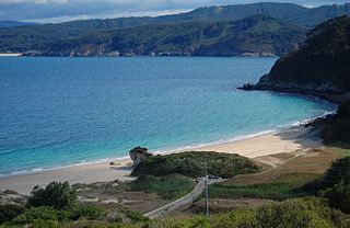
The Bay of Biscay is a gulf of the northeast Atlantic Ocean located south of the Celtic Sea. It lies along the western coast of France from Point Penmarc'h to the Spanish border, and along the northern coast of Spain, extending westward to Cape Ortegal. The southern area of the Bay of Biscay that washes over the northern coast of Spain is known locally as the Cantabrian Sea.

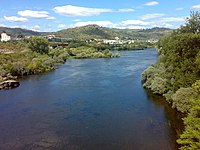
The Douro is the largest river of the Iberian Peninsula by discharge. It rises near Duruelo de la Sierra in the Spanish province of Soria, meanders briefly south, then flows generally west through the northern part of the Meseta Central in Castile and León into northern Portugal. Its largest tributary is the right-bank Esla. The Douro flows into the Atlantic Ocean at Porto, the second largest city of Portugal.

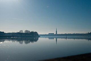
Cantabria is an autonomous community and province in northern Spain with Santander as its capital city. It is called a comunidad histórica, a historic community, in its current Statute of Autonomy. It is bordered on the east by the Basque autonomous community, on the south by Castile and León, on the west by the Principality of Asturias, and on the north by the Cantabrian Sea, which forms part of the Bay of Biscay.

Huelva is a municipality of Spain and the capital of the province of Huelva, in the autonomous community of Andalusia. Located in the southwest of the Iberian Peninsula, it sits between the estuaries of the Odiel and Tinto rivers on the Atlantic coast of the Gulf of Cádiz. According to the 2010 census, the city had a population of 149,410.

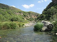
The Noguera Pallaresa is a river in Catalonia, Spain.

The main European watershed is the drainage divide ("watershed") which separates the basins of the rivers that empty into the Atlantic Ocean, the North Sea and the Baltic Sea from those that feed the Mediterranean Sea, the Adriatic Sea and the Black Sea. It stretches from the tip of the Iberian Peninsula at Gibraltar in the southwest to the endorheic basin of the Caspian Sea in Russia in the northeast.

The Autovía A-49 is a major highway in Andalusia, Spain. It starts on the ring road of Seville and heads west with a spur south A-483 to Almonte, the Costa de la Luz and the Doñana National Park. The road crosses the Rio Tinto and the Odiel river north of Huelva and ends on the Portugal–Spain border 133 km west of Seville where it connects to the A22 motorway (Portugal) on the Guadiana International Bridge over the Guadiana River. It is also European route E1.
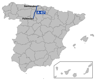
The Autovía A-67 is a highway in north west Spain. It connects the Cantabrian Atlantic Coast at Santander to Palencia. It follows the route of the N-611.

The Arga is a river of Navarre, in Spain, and is a tributary of the Aragón River, itself a tributary of the river Ebro. The Arga was known as the river Runa in antiquity. Situated in the north-east of Spain, the river stretches some 145 kilometres (90 mi) and has a basin of 2,759 square kilometres (1,065 sq mi), of which 2,652 square kilometres (1,024 sq mi) is in Navarre and the remaining 107 square kilometres (41 sq mi) is in the province of Alava. The source of the river is to the north of the village Esteríbar, near the border with France, and it empties into the Aragón River near Funes.

Campoo is a comarca (district) of Cantabria (Spain) located in the High Ebro. With an area of slightly more than 1,000 km2, it includes the municipalities of Hermandad de Campoo de Suso, Campoo de Enmedio, Campoo de Yuso, Valdeolea, Valdeprado del Río, Valderredible, Reinosa, Las Rozas de Valdearroyo, Santiurde de Reinosa, Pesquera, and San Miguel de Aguayo. The local inhabitants are called Campurrians . Its highest elevation is the Cuchillón peak, and the lowest is Pesquera, with the capital, Reinosa at 850 m.
The Esla is a river in the provinces of León and Zamora in the northwest of Spain. It is a tributary of the Duero River that starts in the Cantabrian Mountains and is 275 kilometres (171 mi) long. Its direction of flow is from north to south. It is the largest tributary of the Duero in terms of discharge; in fact, at its mouth at the confluence with the Duero, it has a greater discharge than the volume in the main river.
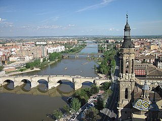
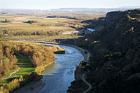
The Ebro is a river of the north and northeast of the Iberian Peninsula, in Spain. It rises in Cantabria and flows 930 kilometres (580 mi), almost entirely in an east-southeast direction. It flows into the Mediterranean Sea, forming a delta in the Province of Tarragona, in southern Catalonia. In the Iberian peninsula, it ranks second in length after the Tagus and second in discharge volume, and drainage basin, after the Douro. It is the longest river entirely within Spain; the other two mentioned flow into Portugal. It is also the second-longest river in the Mediterranean basin, after the Nile.

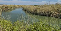
The Odiel is a river in the Atlantic basin in southern Spain, more precisely in the province of Huelva, Andalusia. It originates at Marimateos in the Sierra de Aracena at an elevation of 660 metres (2,170 ft) above sea level. At the Punta del Sebo, it joins the Rio Tinto to form the Huelva Estuary. Its principal tributaries are the Escalada, Meca, Olivargas, Oraque, Santa Eulalia, and El Villar. Its basin covers 990 square kilometres (380 sq mi).

The physical geography of the Basque Country is very diverse despite the small size of the region. The territory hosts a blend of green and brown to yellowish tones, featuring hilly terrain altogether. The Basque Country spreads from the rough coastal landscape to the semi-desert of the Bardenas on the south-eastern fringes of Navarre.

The topographical relief of Spain is characterized by being quite high, with an average altitude of 660 meters above sea level, quite mountainous compared to other European countries and only surpassed by Switzerland, Austria, Albania, Montenegro, North Macedonia and the microstates of Andorra and Liechtenstein. In peninsular Spain, the terrain is articulated around a large Meseta Central that occupies most of the center of the Iberian Peninsula. Outside the plateau, there is the depression of the Guadalquivir river, located in the southwest of the peninsula, and the Ebro river depression, located in the northeast.

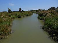
The Piedras River is a coastal river in southwestern Spain, whose course is located entirely in the province of Huelva. It rises in the municipality of El Almendro, although most of the streams that give rise to it and that come from the Sierra del Almendro, are born in the municipality of Villanueva de los Castillejos. It runs from north to south and flows between the Flecha de Nueva Umbría (Lepe) and Nuevo Portil (Cartaya).

The Ebro Hydrographic Confederation is the organization that manages, regulates and maintains the water and irrigation of the Ebro hydrographic basin. The organization's headquarters are in Zaragoza and it was the first institution created in the world with the objective of managing an entire river basin in a unitary manner.