Residential cluster development

Last updated

A residential cluster development, or open space development, is the grouping of residential properties on a development site to use the extra land as open space, recreation or agriculture. It is increasingly becoming popular in subdivision development because it allows the developer to spend much less on land and obtain much the same price per unit as for detached houses. The shared garden areas can be a source of conflict, however. Claimed advantages include more green/public space, closer community, and an optimal storm water management. Cluster development often encounters planning objections.[ citation needed ]

Contents

According to William H. Whyte, the author of “Cluster Development” [1] there are two types of cluster development: townhouse development and super development. Examples of townhouse development include Morrell Park, Philadelphia, Pennsylvania, Hartshone in Richmond, and Dudley Square in Shreveport. Examples of super development include Reston, Virginia, Crofton, Maryland, and Americana Fairfax in Virginia.

Background

In many ways, cluster development has been practiced since the earliest communities from the medieval village to the New England town. However, it was formalized as a modern concept only by the onset of suburban sprawl and ubiquity of detached house developments. The idea of a cluster development was created as the alternative to the conventional subdivision.

The first conscious application of a cluster development was in Radburn, New Jersey, in 1928. It was based on English planning and Ebenezer Howard’s Garden City movement but used principles of cluster development. Following Radburn, many other towns in New Jersey applied those principles to their planning notably the village green in Hillsborough, New Jersey, and Brunswick Hill in South Brunswick. In the rest of the country the use of cluster development grew in principally in Maryland and Virginia, notably in Reston and American Fairfax County.

Currently cluster development is applied all over the United States. There is particularly a strong push for it in the Midwestern States that have had significant problems with urban sprawl, such as Minnesota, Illinois, Ohio, and Wisconsin.

Cluster development, also known as conservation development, is a site planning approach that is an alternative to conventional subdivision development. It is a practice of low-impact development that groups residential properties in a proposed subdivision closer together in order to utilize the rest of the land for open space, recreation or agriculture. Cluster development differs from a planned unit development (PUD), which contains a mix of residential, commercial, industrial, or other uses, but the cluster development primarily focuses on residential areas. [1]

Purpose

The purpose of cluster development is to:

  1. promote integrated site design that is considerate to the natural features and topography
  2. protect environmentally sensitive areas of the development site, as well as permanently preserve important natural features, prime agricultural land, and open space
  3. minimize non-point source pollution through reducing the area of impervious surfaces on site
  4. encourage saving costs on infrastructure and maintenance through practices such as decreasing the area that needs to be paved and the decreasing distance that utilities need to be run
  5. the primary purpose is to create more area for open space, recreation and more social interaction [2]

Benefits

Thanks to there being more porous ground coverings and fewer impervious surfaces such as asphalt and concrete, the risk of flooding and erosion from stormwater is reduced. Economical benefits of cluster development can include there being less infrastructure to build— fewer roads, sewers, and utility lines. The higher density of the clusters of housing also tends to mean more efficiency for services such as public transit, and can also promote increased bicycle usage and the encouragement of pedestrians. The extra open space made available by this type of development leaves room for parks, trails, and community-supported agriculture.

Issues

Following World War II, migration from the cities to suburbs became a dominant trend in America. People were acquiring any land they could find; as a result developers attempted to squeeze as many lots as they could on development sites. Communities then developed zoning regulations to limit the number of units and density allowed on a site. Though this zoning protected land for communities and to an extent preserved land from development, it was what ultimately led to the suburban sprawl as we know it today. [1] It is this zoning that cluster development attempts to amend, and is the primary issue it faces.

Most municipalities have established zoning which restricts developers, planning boards and communities to use only this conventional subdivision development. Thus, the practice of traditional development is difficult to change because of the set standard, familiarly of the procedure, and the fear of undertaking something new. In response to this, groups such as the American Planning Association (APA) have developed a model ordinance that provides the framework for cluster development. This ordinance is not difficult to implement administratively, but politically, it is problematic because of conservative resistance.

People's perception of personal space has a large part to do with this resistance. Many cases people chose to live in suburbs with the intention of having a large lot property; therefore, it is hard to convince those individuals to live closer together. Convincing people to accept small lot sizes and higher density living remains one of the biggest obstacles of cluster development. This obstacle can be mostly overcome with proper site design, which grants homes unobstructed views and effective private space. As well as educating people about the benefits of having better community and open space can serve as encouragement to change perceptions.

An additional obstacle to cluster development is the difficulty for creating small lot sizes when no municipal sewer system is in place. When septic systems are used, enough land needs to be available on each building lot for a leach field (sometimes land is required for two leach fields, the additional land set aside as a back-up). The amount of land needed is in proportion to the size of the septic system and the soil conditions, which must allow for the percolation of wastewater safely into the ground. In areas where well water is used, additional lot area may be required to sufficiently separate the well from the leach field. This can lead to minimum lot sizes of 1-acre (4,000 m2) or more, making cluster development difficult.

However, installing a package wastewater treatment plant (WWTP) for the development (which acts as a small cluster plant, eliminating the need for individual septic tanks) or using biofilters with each septic system make smaller lot sizes acceptable. [3] In addition, providing a package WWTP reduces the diameter and depth of collection sewer lines for the cluster, thus reducing the overall cost of infrastructure.

The final primary issue with cluster development is the issue of dealing with open, recreational, and agricultural space. These areas serve as benefits in many respects but are also issues that are required to be dealt with. The maintenance of open and recreational space requires the formation of home owners associations that necessitate fees for taxes, insurance and general upkeep. This would not be necessary under a typical subdivision, but people would have their own maintenance expenses. As to agriculture: people enjoying living next to it until there is a need to apply fertilizer or pesticides. This fact cannot be avoided, but through proper use of cluster development, there can be wider gaps and barriers between agricultural land and residential properties, which would limit exposure to unwanted byproducts.

Application

The model ordinance for cluster development is section 4.7 in the Smart Growth Codes, [2] issued by the American Planning Association. Along with introducing the concept of residential cluster development, the ordinance outlines the process of application, site planning and implementation.

The primary requisites for application of cluster development are that all principal or accessory uses are allowed and that multifamily dwelling, duplexes, and townhouses are permitted. As well the application of maximal lot coverage, floor area ratios, building height, and parking requirements to the entire site as opposed to the individual lot. Provisions of a cluster development require that the site is at least 2 to 5 acres (20,000 m2) and there is no minimum to lot dimensions; furthermore each house can be no more than 12 feet (3.7 m) from the street with yard that is at least 25 feet (7.6 m). There also needs to be the ability to place more than one principal building on each lot, and lastly no less than 25% of the site is used for open space.

Included in the application, the site plan is required to consist of the street and sidewalk layout, the maximum number and type of dwelling units proposed, and how much area they will occupy, with calculations; as well as the area of parking, open space, and other accessories. To calculate the permitted amount of dwellings, one must measure the gross area of the site in acres and tenths of an acre, then subtract the gross area of the public and private streets and public dedicated improvement; the remainder will be the build able area. Then divide the net build able area by the smallest minimum lot size; round this number to the nearest lower number and the figure will be the maximum number of units.

Design features

There are various distinct design features in cluster development notably: the consideration of natural features/topography, smaller lot size, the use of cul-de-sacs, and the use of certain waste/storm water management techniques.

Along with site design, waste/storm water management design features are a principle aspect of cluster development. By the maximizing of over land water flow and the strategic use of landforms and plants to slow, hold, and treat runoff, most stormwater can be handled. As well, there many options to deal with wastewater. Techniques such as community drain fields, irrigation systems, and package plants can dramatically reduce the cost of infrastructure and improve the environment. [4]

Related Research Articles

<span class="mw-page-title-main">Zoning</span> Government policy allowing certain uses of land in different places

In urban planning, zoning is a method in which a municipality or other tier of government divides land into "zones", each of which has a set of regulations for new development that differs from other zones. Zones may be defined for a single use, they may combine several compatible activities by use, or in the case of form-based zoning, the differing regulations may govern the density, size and shape of allowed buildings whatever their use. The planning rules for each zone determine whether planning permission for a given development may be granted. Zoning may specify a variety of outright and conditional uses of land. It may indicate the size and dimensions of lots that land may be subdivided into, or the form and scale of buildings. These guidelines are set in order to guide urban growth and development.

<span class="mw-page-title-main">Kildeer, Illinois</span> Village in Illinois, United States

Kildeer is a village in southwestern Lake County, Illinois, United States, and a suburb of Chicago. Per the 2020 census, the population was 4,091. It has limited development to custom houses on large lots, and has worked to preserve natural features and open space.

<span class="mw-page-title-main">Reston, Virginia</span> Census-designated place in Virginia, United States

Reston is a census-designated place in Fairfax County, Virginia, United States, and a principal city of the Washington metropolitan area. As of the 2020 U.S. Census, Reston's population was 63,226.

Growth management, in the United States, is a set of techniques used by the government to ensure that as the population grows that there are services available to meet their demands. Growth management goes beyond traditional land use planning, zoning and subdivision controls in both the characteristics of development influenced and the scope of government powers used. These are not necessarily only government services. Other demands such as the protection of natural spaces, sufficient and affordable housing, delivery of utilities, preservation of buildings and places of historical value, and sufficient places for the conduct of business are also considered.

<span class="mw-page-title-main">Residential area</span> Land use in which housing predominates, as opposed to industrial and commercial areas

A residential area is a land used in which housing predominates, as opposed to industrial and commercial areas.

<span class="mw-page-title-main">Subdivision (land)</span> Divided piece of land

Subdivisions are the act of dividing land into pieces that are easier to sell or otherwise develop, usually via a plat. The former single piece as a whole is then known as a subdivision. Subdivisions may be simple, involving only a single seller and buyer, or complex, involving large tracts of land divided into many smaller parcels. If it is used for housing it is typically known as a housing subdivision or housing development, although some developers tend to call these areas communities.

<span class="mw-page-title-main">Floor area ratio</span> Building density measurement

Floor area ratio (FAR) is the ratio of a building's total floor area to the size of the piece of land upon which it is built. It is often used as one of the regulations in city planning along with the building-to-land ratio. The terms can also refer to limits imposed on such a ratio through zoning. FAR includes all floor areas but is indifferent to their spatial distribution on the lot whereas the building coverage ratio measures building footprint on the lot but is indifferent to building height.

Onsite sewage facilities (OSSF), also called septic systems, are wastewater systems designed to treat and dispose of effluent on the same property that produces the wastewater, in areas not served by public sewage infrastructure.

A planned unit development (PUD) is a type of flexible, non-Euclidean zoning device that redefines the land uses allowed within a stated land area. PUDs consist of unitary site plans that promote the creation of open spaces, mixed-use housing and land uses, environmental preservation and sustainability, and development flexibility. Areas rezoned as PUDs include building developments, designed groupings of both varied and compatible land uses—such as housing, recreation, commercial centers, and industrial parks—within one contained development or subdivision. Developed areas vary in size and by zoned uses, such as industrial, commercial, and residential. Other types of similar zoning devices include floating zones, overlay zones, special district zoning, performance-based codes, and transferable development rights.

SmartCode is a unified land development ordinance template for planning and urban design. Originally developed by Duany Plater-Zyberk & Company, this open source program is a model form-based unified land development ordinance designed to create walkable neighborhoods across the full spectrum of human settlement, from the most rural to the most urban, incorporating a transect of character and intensity within each. It folds zoning, subdivision regulations, urban design, and basic architectural standards into one compact document. Because the SmartCode enables community vision by coding specific outcomes that are desired in particular places, it is meant to be locally calibrated by professional planners, architects, and attorneys.

<span class="mw-page-title-main">Conservation development</span> Controlled-growth land use development

Conservation development, also known as conservation design, is a controlled-growth land use development that adopts the principle for allowing limited sustainable development while protecting the area's natural environmental features in perpetuity, including preserving open space landscape and vista, protecting farmland or natural habitats for wildlife, and maintaining the character of rural communities. A conservation development is usually defined as a project that dedicates a minimum of 50 percent of the total development parcel as open space. The management and ownership of the land are often formed by the partnership between private land owners, land-use conservation organizations and local government. It is a growing trend in many parts of the country, particularly in the Western United States. In the Eastern United States, conservation design has been promoted by some state and local governments as a technique to help preserve water quality.

<span class="mw-page-title-main">Land lot</span> Tract or parcel of land that is owned

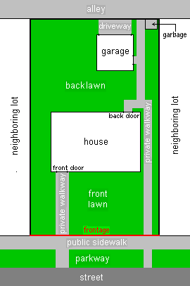
In real estate, a lot or plot is a tract or parcel of land owned or meant to be owned by some owner(s). A plot is essentially considered a parcel of real property in some countries or immovable property in other countries. Possible owners of a plot can be one or more persons or another legal entity, such as a company, corporation, organization, government, or trust. A common form of ownership of a plot is called fee simple in some countries.

Henry Wright, was a planner, architect, and major proponent of the garden city, an idea characterized by green belts and created by Sir Ebenezer Howard.

Build-out is an urban planner’s estimate of the amount and location of potential development for an area. Sometimes called a "lot-yield analysis", build-out is one step of the land use planning process. Evaluation of potential development impacts begins with a build-out analysis.

<span class="mw-page-title-main">Medium-density housing</span>

Medium-density housing is a term used within urban planning and academic literature to refer to a category of residential development that falls between detached suburban housing and large multi-story buildings. There is no singular definition of medium-density housing as its precise definition tends to vary between jurisdiction. Scholars however, have found that medium density housing ranges from about 25 to 80 dwellings per hectare, although most commonly sits around 30 and 40 dwellings/hectare. Typical examples of medium-density housing include duplexes, triplexes, townhouses, row homes, detached homes with garden suites, and walk-up apartment buildings.

<span class="mw-page-title-main">Zoning in the United States</span> Provision in urban planning in the United States

Zoning is a law that divides a jurisdiction's land into districts, or zones, and limits how land in each district can be used. In the United States, zoning includes various land use laws enforced through the police power rights of state governments and local governments to exercise authority over privately owned real property.

Exclusionary zoning is the use of zoning ordinances to exclude certain types of land uses from a given community, especially to regulate racial and economic diversity. In the United States, exclusionary zoning ordinances are standard in almost all communities. Exclusionary zoning was introduced in the early 1900s, typically to prevent racial and ethnic minorities from moving into middle- and upper-class neighborhoods. Municipalities use zoning to limit the supply of available housing units, such as by prohibiting multi-family residential dwellings or setting minimum lot size requirements. These ordinances raise costs, making it less likely that lower-income groups will move in. Development fees for variance, a building permit, a certificate of occupancy, a filing (legal) cost, special permits and planned-unit development applications for new housing also raise prices to levels inaccessible for lower income people.

In recent years, communities in Massachusetts have adopted resource protection zoning (RPZ) as a tool to protect natural resources and open space. RPZ, which was originally passed in Shutesbury, Massachusetts in spring 2008, includes elements of conservation subdivision regulations and cluster development bylaws, to regulate new subdivisions of land in a manner that maximizes the protection of natural resources.

<span class="mw-page-title-main">Howard County Department of Planning and Zoning</span>

The Howard County Department of Planning and Zoning (DPZ) manages planning and development in Howard County, Maryland, a Central Maryland jurisdiction equidistant between Baltimore, Maryland and Washington, D.C.

<span class="mw-page-title-main">Missing middle housing</span>

Missing middle housing refers to a lack of medium-density housing in the North American context. It is often characterized by a range of multi-family or clustered housing types that are compatible in scale with single-family or transitional neighborhoods. It is usually used to describe a phenomenon in Canada and the United States, and those countries which have sought to replicate their style of urban planning, which lacks this type of medium-density housing due to car dependant suburban sprawl and zoning regulations.

References

See also