Related Research Articles

The National Geospatial-Intelligence Agency (NGA) is a combat support agency within the United States Department of Defense whose primary mission is collecting, analyzing, and distributing geospatial intelligence (GEOINT) in support of national security. Initially known as the National Imagery and Mapping Agency (NIMA) from 1996 to 2003, it is a member of the United States Intelligence Community.
The Great Firewall is the combination of legislative actions and technologies enforced by the People's Republic of China to regulate the Internet domestically. Its role in internet censorship in China is to block access to selected foreign websites and to slow down cross-border internet traffic. The Great Firewall operates by checking transmission control protocol (TCP) packets for keywords or sensitive words. If the keywords or sensitive words appear in the TCP packets, access will be closed. If one link is closed, more links from the same machine will be blocked by the Great Firewall. The effect includes: limiting access to foreign information sources, blocking foreign internet tools and mobile apps, and requiring foreign companies to adapt to domestic regulations.

Satellite images are images of Earth collected by imaging satellites operated by governments and businesses around the world. Satellite imaging companies sell images by licensing them to governments and businesses such as Apple Maps and Google Maps.

Google Maps is a web mapping platform and consumer application offered by Google. It offers satellite imagery, aerial photography, street maps, 360° interactive panoramic views of streets, real-time traffic conditions, and route planning for traveling by foot, car, bike, air and public transportation. As of 2020, Google Maps was being used by over one billion people every month around the world.
Google Earth is a computer program that renders a 3D representation of Earth based primarily on satellite imagery. The program maps the Earth by superimposing satellite images, aerial photography, and GIS data onto a 3D globe, allowing users to see cities and landscapes from various angles. Users can explore the globe by entering addresses and coordinates, or by using a keyboard or mouse. The program can also be downloaded on a smartphone or tablet, using a touch screen or stylus to navigate. Users may use the program to add their own data using Keyhole Markup Language and upload them through various sources, such as forums or blogs. Google Earth is able to show various kinds of images overlaid on the surface of the Earth and is also a Web Map Service client. In 2019, Google revealed that Google Earth now covers more than 97 percent of the world, and has captured 10 million miles of Street View imagery.
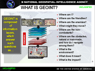
In the United States, geospatial intelligence (GEOINT) is intelligence about the human activity on Earth derived from the exploitation and analysis of imagery, signals, or signatures with geospatial information. GEOINT describes, assesses, and visually depicts physical features and geographically referenced activities on the Earth. GEOINT, as defined in US Code, consists of imagery, imagery intelligence (IMINT) and geospatial information.
OpenStreetMap (OSM) is a free, open geographic database updated and maintained by a community of volunteers via open collaboration. Contributors collect data from surveys, trace from aerial imagery and also import from other freely licensed geodata sources. OpenStreetMap is freely licensed under the Open Database License and as a result commonly used to make electronic maps, inform turn-by-turn navigation, assist in humanitarian aid and data visualisation. OpenStreetMap uses its own topology to store geographical features which can then be exported into other GIS file formats. The OpenStreetMap website itself is an online map, geodata search engine and editor.
Censorship in South Korea is implemented by various laws that were included in the constitution as well as acts passed by the National Assembly over the decades since 1948. These include the National Security Act, whereby the government may limit the expression of ideas that it perceives "praise or incite the activities of anti-state individuals or groups". Censorship was particularly severe during the country's authoritarian era, with freedom of expression being non-existent, which lasted from 1948 to 1993.
Google and its subsidiary companies, such as YouTube, have removed or omitted information from its services in order to comply with company policies, legal demands, and government censorship laws.

Web mapping or an online mapping is the process of using, creating, and distributing maps on the World Wide Web, usually through the use of Web geographic information systems. A web map or an online map is both served and consumed, thus, web mapping is more than just web cartography, it is a service where consumers may choose what the map will show.
Critical cartography is a set of mapping practices and methods of analysis grounded in critical theory, specifically the thesis that maps reflect and perpetuate relations of power, typically in favor of a society's dominant group. Critical cartographers aim to reveal the “‘hidden agendas of cartography’ as tools of socio-spatial power”. While the term "critical cartography" often refers to a body of theoretical literature, critical cartographers also call for practical applications of critical cartographic theory, such as counter-mapping, participatory mapping, and neogeography.
Cartographic censorship is the deliberate modification of publicly available maps in order to disguise, remove, or obfuscate potentially strategic locations or buildings, such as military bases, power plants or transmitters. Sensitive objects and places have been removed from maps since historic times, sometimes as a disinformation tactic in times of war, and also to serve competitive political and economic interests, such as during the Age of Discovery when strategic geographic information was highly sought after. In modern times requests for censorship are sent to Google Earth for certain sites that are deemed to pose security risks for national governments.
Bhuvan is an Indian web-based utility which allows users to explore a set of geographic content prepared by the Indian Space Research Organisation. The content which the utility serves is mostly restricted to within Indian boundaries and is offered in four regional languages. The content includes thematic maps related to disasters, agriculture, water resources, land cover, and processed satellite data generated by ISRO.
Bing Maps Platform is a geospatial mapping platform produced by Microsoft. It allows developers to create applications that layer location-relevant data on top of licensed map imagery. The imagery includes samples taken by satellite sensors, aerial cameras, Streetside imagery, 3D city models and terrain.
Geographic information systems (GIS) play a constantly evolving role in geospatial intelligence (GEOINT) and United States national security. These technologies allow a user to efficiently manage, analyze, and produce geospatial data, to combine GEOINT with other forms of intelligence collection, and to perform highly developed analysis and visual production of geospatial data. Therefore, GIS produces up-to-date and more reliable GEOINT to reduce uncertainty for a decisionmaker. Since GIS programs are Web-enabled, a user can constantly work with a decision maker to solve their GEOINT and national security related problems from anywhere in the world. There are many types of GIS software used in GEOINT and national security, such as Google Earth, ERDAS IMAGINE, GeoNetwork opensource, and Esri ArcGIS.
Internet censorship in South Korea is prevalent, and contains some unique elements such as the blocking of pro-North Korea websites, and to a lesser extent, Japanese websites, which led to it being categorized as "pervasive" in the conflict/security area by OpenNet Initiative. South Korea is also one of the few developed countries where pornography is largely illegal, with the exception of social media websites which are a common source of legal pornography in the country. Any and all material deemed "harmful" or subversive by the state is censored. The country also has a "cyber defamation law", which allow the police to crack down on comments deemed "hateful" without any reports from victims, with citizens being sentenced for such offenses.
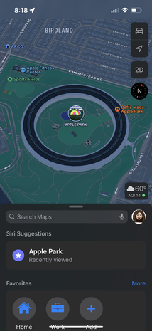
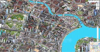
Apple Maps is a web mapping service developed by Apple Inc. The default map system of iOS, iPadOS, macOS, and watchOS, it provides directions and estimated times of arrival for driving, walking, cycling, and public transportation navigation. A "Flyover" mode shows certain densely populated urban centers and other places of interest in a 3D landscape composed of models of buildings and structures.
Baidu Maps is a desktop and mobile web mapping service application and technology provided by Baidu, offering satellite imagery, street maps, street view and indoor view perspectives, as well as functions such as a route planner for traveling by foot, car, or with public transport. Android and iOS applications are available.
Under Chinese law, the use of geographic information in the People's Republic of China is restricted to entities that have special authorization from the administrative department for surveying and mapping under the State Council. Consequences of the restriction include fines for unauthorized surveys, lack of geotagging information on many cameras when the GPS chip detects a location within China, and incorrect alignment of street maps with satellite maps in various applications.
References
- 1 2 3 KIM, IN-KYOUNG; SEO, JI-EUN (2023-03-06). "Apple request for detailed Korean mapping data rejected". Korea JoongAng Daily . Retrieved 2023-10-09.
- 1 2 3 Cheng, Jonathan (2016-05-17). "Google Challenges South Korea Over Mapping Restrictions". The Wall Street Journal . ISSN 0099-9660 . Retrieved 2023-10-09.
- 1 2 3 Han, Jay Jiwook (2021-12-07). "Can I Use Google Maps in Korea? Which Navigation Apps in Korea are best?". IVisitKorea. Retrieved 2023-10-09.
- 1 2 3 "Why South Korea refuses to share mapping data with Google". Christian Science Monitor. ISSN 0882-7729 . Retrieved 2023-10-09.
- 1 2 Yoon, Julia (2018). "South Korean Data Localization: Shaped by Conflict". The Henry M. Jackson School of International Studies.
- 1 2 KH디지털2 (2016-08-10). "Controversy persists in Korea over restrictions on Google Maps". The Korea Herald . Retrieved 2023-10-09.
{{cite web}}: CS1 maint: numeric names: authors list (link) - 1 2 3 4 5 Um, Dan-Bi (October 2022). "Legal Evaluation for Security Exception Claims About the Cross-Border Transfer of the Korean Map: A Case of Google". Social Science Computer Review. 40 (5): 1114–1132. doi:10.1177/0894439321998058. ISSN 0894-4393. S2CID 233711102.
- 1 2 3 Fairchild, Keshia Badalge, Cullen (2018-02-26). "One thing North Korea has that the South doesn't: Google Maps". Asia Times. Retrieved 2023-10-09.
{{cite web}}: CS1 maint: multiple names: authors list (link) - ↑ "Why Google Maps is useless in South Korea, and how to get around without it". Korean Film Biz Zone. Retrieved 2023-10-09.
- ↑ yejichung (2023-07-11). "South Korea's tech paradox: How local constraints thwart its global ambitions". KOREA PRO. Retrieved 2023-10-09.
- ↑ Park, Nohyoung (2021). "A Korean Approach to Data Localization". The Korean Way With Data: How the World’s Most Wired Country Is Forging a Third Way.
- ↑ Zwirko, Colin (2022-12-19). "South Korean outlets censor North Korean satellite images of Seoul area". NK PRO. Retrieved 2023-10-09.