
The Mendip Hills is a range of limestone hills to the south of Bristol and Bath in Somerset, England. Running from Weston-super-Mare and the Bristol Channel in the west to the Frome valley in the east, the hills overlook the Somerset Levels to the south and the Chew Valley and other tributaries of the Avon to the north. The hills gave their name to the former local government district of Mendip, which administered most of the local area until April 2023. The higher, western part of the hills, covering 198 km2 (76 sq mi) has been designated an Area of Outstanding Natural Beauty (AONB), which gives it a level of protection comparable to a national park.

East Harptree is a village and civil parish in Somerset, England. It is situated 5 miles (8.0 km) north of Wells and 15 miles (24.1 km) south of Bristol, on the northern slope of the Mendip Hills overlooking the Chew Valley. The parish has a population of 644. The parish includes the hamlet of Coley.

Temple Cloud is a village in the Chew Valley in Somerset on the A37 road. It is in the civil parish of Temple Cloud with Cameley and in the council area of Bath and North East Somerset. It is 10 miles (16 km) from Bristol and 5 miles (8 km) from the town of Midsomer Norton. The villages of Cameley and Clutton are nearby.
The Chew Valley is an affluent area in North Somerset, England, named after the River Chew, which rises at Chewton Mendip, and joins the River Avon at Keynsham. Technically, the area of the valley is bounded by the water catchment area of the Chew and its tributaries; however, the name Chew Valley is often used less formally to cover other nearby areas, for example, Blagdon Lake and its environs, which by a stricter definition are part of the Yeo Valley. The valley is an area of rich arable and dairy farmland, interspersed with a number of villages.
West Harptree is a small village and civil parish in the Chew Valley, Somerset within the unitary district of Bath and North East Somerset. The parish has a population of 439.

Harptree Combe is a 13.63-hectare (33.68-acre) Site of Special Scientific Interest (SSSI) near East Harptree notified in 1954. "Combe" or "coombe" is a West Country word meaning a steep-sided valley. It is also the site of a 19th-century aqueduct and is overlooked by the site of a castle dating from around 1100.

Priddy is a village in Somerset, England in the Mendip Hills, close to East Harptree and 4 miles (6 km) north-west of Wells. It is in the local government district of Mendip.

Cary Castle stood on Lodge Hill overlooking the town of Castle Cary, Somerset, England. It is a Scheduled Ancient Monument.
Stockport Castle was a promontory castle in Stockport, Cheshire. The castle was in the medieval town, overlooking a ford over the River Mersey. It was first documented in 1173, but the next mention of it is in 1535 when it was in ruins. What remained of the castle was demolished in 1775.

The Church of St Mary Magdalene in Chewton Mendip, Somerset, England, was built in the 1540s and has been designated as a Grade I listed building. It is dedicated to Jesus' companion Mary Magdalene.

The county of Somerset is in South West England, bordered by the Bristol Channel and the counties of Bristol and Gloucestershire to the north, and Wiltshire to the east, Dorset to the south, and Devon to the west. The climate, influenced by its proximity to the Atlantic Ocean and the prevailing westerly winds, tends to be mild, damp and windy.
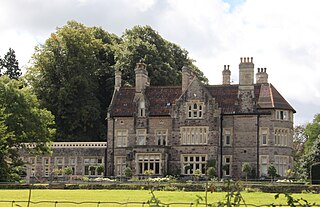
Eastwood Manor is a Grade II listed building in the village of East Harptree in the English County of Somerset.
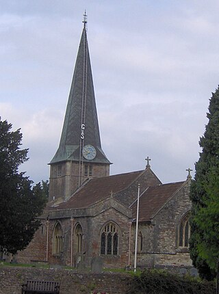
The Church of St Mary in West Harptree within the English county of Somerset was built in the 12th century, with the spire being added in the 13th century. It is a Grade II* listed building.

Priddy Nine Barrows Cemetery and Ashen Hill Barrow Cemetery are a collection of round barrows, dating from the Bronze Age, near Priddy in the English county of Somerset. They are designated as ancient monuments.

Bath and North East Somerset is a unitary authority created on 1 April 1996, following the abolition of the County of Avon, which had existed since 1974. Part of the ceremonial county of Somerset, Bath and North East Somerset occupies an area of 220 square miles (570 km2), two-thirds of which is green belt. It stretches from the outskirts of Bristol, south into the Mendip Hills and east to the southern Cotswold Hills and Wiltshire border. The city of Bath is the principal settlement in the district, but BANES also covers Keynsham, Midsomer Norton, Radstock and the Chew Valley. The area has a population of 170,000, about half of whom live in Bath, making it 12 times more densely populated than the rest of the area.

Mendip is a local government district of Somerset in England. The Mendip district covers a largely rural area of 285 square miles (738 km2) ranging from the Mendip Hills through on to the Somerset Levels. It has a population of approximately 110,000. The administrative centre of the district is Shepton Mallet but the largest town is Frome.

There are over 670 scheduled monuments in the ceremonial county of Somerset in South West England. The county consists of a non-metropolitan county, administered by Somerset Council. The two administratively independent unitary authorities, which were established on 1 April 1996 following the breakup of the county of Avon, are North Somerset and Bath and North East Somerset. These unitary authorities include areas that were once part of Somerset before the creation of Avon in 1974.

