
Palau, officially the Republic of Palau, is an island country in the Micronesia subregion of Oceania in the western Pacific. The republic consists of approximately 340 islands and connects the western chain of the Caroline Islands with parts of the Federated States of Micronesia. It has a total area of 466 square kilometers (180 sq mi), making it one of the smallest countries in the world. The most populous island is Koror, home to the country's most populous city of the same name. The capital Ngerulmud is located on the largest island of Babeldaob, in Melekeok State. Palau shares maritime boundaries with international waters to the north, the Federated States of Micronesia to the east, Indonesia to the south, and the Philippines to the northwest.

Koror is the state comprising the main commercial centre of the Republic of Palau. It consists of several islands, the most prominent being Koror Island. It is Palau’s most populous state.

Peleliu is an island in the island nation of Palau. Peleliu, along with two small islands to its northeast, forms one of the sixteen states of Palau. The island is notable as the location of the Battle of Peleliu in World War II.
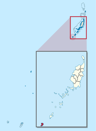
Angaur, or Ngeaur in Palauan, is an island and state in the island nation of Palau.

Babeldaob is the largest island in the island nation of the Republic of Palau. It is in the western Caroline Islands, and the second largest island in the Micronesia region of Oceania. Palau's capital, Ngerulmud, is located on Babeldaob, in Melekeok State.
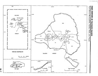
Chuuk Lagoon, previously Truk Atoll, is an atoll in the central Pacific. It lies about 1,800 kilometres northeast of New Guinea and is part of Chuuk State within the Federated States of Micronesia (FSM). A protective reef, 225 kilometres (140 mi) around, encloses a natural harbour 79 by 50 km, with an area of 2,130 km2 (820 sq mi). It has a land area of 93.07 square kilometres, with a population of 36,158 people and a maximal elevation of 443 metres (1,453 ft). Weno city on Weno Island functions as both the atoll's capital and the state capital, and is the largest city in the FSM with its 13,700 people.

The New Caledonian barrier reef is a barrier reef located in New Caledonia in the South Pacific, being the longest continuous barrier reef in the world and the third largest after the Great Barrier Reef of Australia and the Mesoamerican Barrier Reef.

Kayangel (Ngcheangel) is the northernmost state of Palau 24 km (15 mi) north of Koror. The land area is about 1.4 km2 (0.54 sq mi). The population is 54. There is one hamlet in the state - Orukei which is also its capital.

Jellyfish Lake is a marine lake located on Eil Malk island in Palau. Eil Malk is part of the Rock Islands, a group of small, rocky, mostly uninhabited islands in Palau's Southern Lagoon, between Koror and Peleliu. There are about 70 other marine lakes located throughout the Rock Islands. Millions of golden jellyfish migrate horizontally across the lake daily.

Apo Reef is a coral reef system in the Philippines situated in the western waters of Occidental Mindoro province in the Mindoro Strait. Encompassing 34 square kilometres (13 sq mi), it is considered the world's second-largest contiguous coral reef system, and is the largest in the country. The reef and its surrounding waters are protected areas administered as the Apo Reef Natural Park (ARNP). It is one of the best known and most popular diving regions in the country, and is in the tentative list for UNESCO World Heritage Sites.

Eil Malk or Mecherchar is the main island of the Mecherchar Islands, an island group of Palau in the Pacific Ocean. In a more narrow sense, just the southeastern peninsula of Mecherchar is called Eil Malk.
Clear Lake is a marine lake located on Eil Malk island in Palau. Eil Malk is part of the Rock Islands, a group of small, rocky, mostly uninhabited islands in Palau's Southern Lagoon, between Koror and Peleliu. There are about 70 other marine lakes located throughout the Rock Islands. Clear Lake is notable for endemic subspecies of golden jellyfish and is one of five marine lakes in Palau used for several scientific researches in evolutionary biology, the other lakes being Jellyfish Lake, Goby Lake, Uet era Ngermeuangel, Uet era Ongael.
Goby Lake is a marine lake located on Koror island in Palau. There are about 70 other marine lakes located throughout the Rock Islands and Koror. Goby Lake is notable for endemic subspecies of golden jellyfish and is one of five marine lakes in Palau used for several scientific researches in evolutionary biology the other lakes being Jellyfish Lake, Clear Lake (Palau), Uet era Ngermeuangel, Uet era Ongael.
Uet era Ngermeuangel is a marine lake located on Koror island in Palau. There are about 70 other marine lakes located throughout the Rock Islands and Koror. Uet era Ngermeuangel is notable for endemic subspecies of golden jellyfish and is one of five marine lakes in Palau used for several scientific researches in evolutionary biology the other lakes being Jellyfish Lake, Clear Lake (Palau), Goby Lake, Uet era Ongael.
Uet era Ongael is a marine lake located on Ongael Island, Koror, in Palau. There are about 70 other marine lakes located throughout the Rock Islands and Koror. Uet era Ongael is notable for endemic subspecies of golden jellyfish and is one of five marine lakes in Palau used for several scientific researches in evolutionary biology, the other lakes being Jellyfish Lake, Clear Lake, Uet era Ngermeuangel and Goby Lake.

Ulong is a major island and channel of western Palau. It is sometimes called Aulong and originally written Oroolong in English. Ulong is regarded by many as one of the best drift dives in the world.

Lighthouse Reef is an atoll in the Caribbean Sea, the easternmost part of the Belize Barrier Reef and one of its three atolls, the other two being Turneffe Atoll and Glover's Reef. Lighthouse Reef is located about 80 kilometres (50 mi) southeast of Belize City. The atoll is of oblong shape, approximately 35 kilometres (22 mi) long from north to south, and about 8 kilometres (5.0 mi) wide. It forms a shallow sandy lagoon with an area of 120 square kilometres (46 sq mi) and a depth between 2 and 6 metres deep.
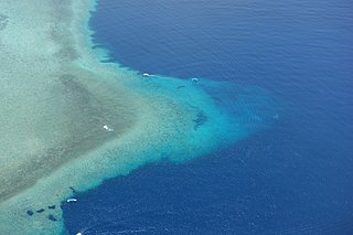
Blue Corner is a section of Palau's barrier reef in the south-east of Koror, close to Ngerukewid and German Channel. Its triangular shape, with step walls on the Pacific Ocean sides, resembles a submerged peninsula. In the north part of the Blue Corner, there is a large underwater cavern called Blue Holes. Due to a high variety of corals and wildlife in the area, the Blue Corner is a popular recreational dive site. It is variously called "the most requested dive in Palau" and "one of the most action-packed scuba dive sites in the world."

The golden jellyfish is a subspecies of spotted jellyfish that inhabits Jellyfish Lake on Eil Malk island in Palau in the western Pacific Ocean. Like the nominate subspecies, it derives part of its nutrition from symbiotic algae (Zooxanthellae) that live in their tissues and part of their nutrition from captured zooplankton.


