
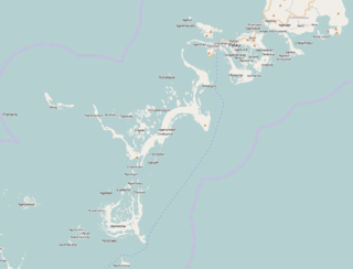
Ulong is a major island and channel of western Palau. [1] It is sometimes called Aulong and originally written Oroolong in English. Ulong is regarded by many as one of the best drift dives in the world. [2]
Ulong is a major island and channel of western Palau. [1] It is sometimes called Aulong and originally written Oroolong in English. Ulong is regarded by many as one of the best drift dives in the world. [2]

Ngerumekaol Pass, also known as Ulong Channel, partially cuts through the reef near the Island. [3] The channel stretches about 500 metres (1,600 ft), with an average width of 33 metres (108 ft) and leads into a coral reef lagoon. [2] There are sharks within the currents of the channel and Ulong Corner. The channel contains giant clams and one of the largest known patches of green lettuce coral in the world. [4] [5] Uruktapel is the largest island southward of Koror; at about 2 miles (3.2 km) off its western point is Ulong. Denges and Eil Malk Passages are passable, but navigation may be difficult in the lagoon between them and Ulong Island. From Ulong to Malakal Harbor, the lagoon is navigable. [6]
Henry Wilson (1740–1810), an English naval captain of the British East India Company was aboard his packet ship Antelope, when it shipwrecked off Ulong Island in 1783; [7] he returned to England with the local Prince Lee Boo. In the late 1700s, the island's inhabitants attempted to defend Ulong from attack along Ikesakes Reef but, having been defeated, were forced to leave. [8] There are Palau Cave Paintings on the island. [9]

The Caribbean Sea is a sea of the Atlantic Ocean in the tropics of the Western Hemisphere. It is bounded by Mexico and Central America to the west and southwest, to the north by the Greater Antilles starting with Cuba, to the east by the Lesser Antilles, and to the south by the northern coast of South America. The Gulf of Mexico lies to the northwest.
The Republic of Palau consists of eight principal islands and more than 250 smaller ones lying roughly 500 miles southeast of the Philippines, in Oceania. The islands of Palau constitute the westernmost part of the Caroline Islands chain. The country includes the World War II battleground of Peleliu and world-famous rock islands. The total land area is 459 km2 (177 sq mi). It has the 42nd largest Exclusive Economic Zone of 603,978 km2 (233,197 sq mi).
An atoll is a ring-shaped island, including a coral rim that encircles a lagoon partially or completely. There may be coral islands or cays on the rim. Atolls are located in warm tropical or subtropical parts of the oceans and seas where corals can grow. Most of the approximately 440 atolls in the world are in the Pacific Ocean.

A lagoon is a shallow body of water separated from a larger body of water by a narrow landform, such as reefs, barrier islands, barrier peninsulas, or isthmuses. Lagoons are commonly divided into coastal lagoons and atoll lagoons. They have also been identified as occurring on mixed-sand and gravel coastlines. There is an overlap between bodies of water classified as coastal lagoons and bodies of water classified as estuaries. Lagoons are common coastal features around many parts of the world.

A coral reef is an underwater ecosystem characterized by reef-building corals. Reefs are formed of colonies of coral polyps held together by calcium carbonate. Most coral reefs are built from stony corals, whose polyps cluster in groups.

Aldabra is the world's second-largest coral atoll, lying south-east of the continent of Africa. It is part of the Aldabra Group of islands in the Indian Ocean that are part of the Outer Islands of the Seychelles, with a distance of 1,120 km (700 mi) southwest of the capital, Victoria on Mahé Island.

The Coral Sea is a marginal sea of the South Pacific off the northeast coast of Australia, and classified as an interim Australian bioregion. The Coral Sea extends 2,000 kilometres (1,200 mi) down the Australian northeast coast. Most of it is protected by the French Natural Park of the Coral Sea and the Australian Coral Sea Marine Park. The sea was the location for the Battle of the Coral Sea, a major confrontation during World War II between the navies of the Empire of Japan, and the United States and Australia.

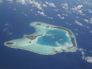
Bora Bora is an island group in the Leeward Islands. The Leeward Islands comprise the western part of the Society Islands of French Polynesia, which is an overseas collectivity of the French Republic in the Pacific Ocean. Bora Bora has a total land area of 30.55 km2 (12 sq mi). The main island, located about 230 kilometres northwest of Papeete, is surrounded by a lagoon and a barrier reef. In the center of the island are the remnants of an extinct volcano, rising to two peaks, Mount Pahia and Mount Otemanu; the highest point is at 727 m (2,385 ft). Bora Bora is part of the Commune of Bora-Bora, which also includes the atoll of Tūpai. The languages spoken in Bora Bora are Tahitian and French. However, due to the high tourism population, many natives of Bora Bora have learned to speak English.

The Rock Islands of Palau, also called Chelbacheb, are a collection of several hundred small limestone or coral uprises in the Southern Lagoon of Palau between Koror and Peleliu, now an incorporated part of Koror State. There are between 250 and 300 islands in the group according to different sources, with an aggregate area of 42 square kilometers (16 sq mi) and a maximum height of 207 meters (679 ft). The islands were declared a UNESCO World Heritage Site in 2012.
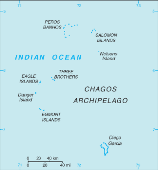
The British Indian Ocean Territory (BIOT) is an archipelago of 55 islands in the Indian Ocean, located south of India. It is situated approximately halfway between Africa and Indonesia. The islands form a semicircular group with an open sea towards the east. The largest, Diego Garcia, is located at the southern extreme end. It measures 60 square kilometres (23 sq mi) and accounts for almost three-quarters of the total land area of the territory. Diego Garcia is the only inhabited island and is home to the joint UK-US naval support facility. Other islands within the archipelago include Danger Island, Three Brothers Islands, Nelson Island, and Peros Banhos, as well as the island groups of the Egmont Islands, Eagle Islands, and the Salomon Islands.
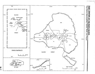
Chuuk Lagoon, previously Truk Atoll, is an atoll in the central Pacific. It lies about 1,800 kilometres northeast of New Guinea, and is part of Chuuk State within the Federated States of Micronesia (FSM). A protective reef, 225 kilometres (140 mi) around, encloses a natural harbour 79 by 50 km, with an area of 2,130 km2 (820 sq mi). It has a land area of 93.07 square kilometres, with a population of 36,158 people and a maximal elevation of 443 metres (1,453 ft). Weno city on Moen Island functions as both the atoll's capital and the state capital, and is the largest city in the FSM with its 13,700 people.

Kayangel (Ngcheangel) is the northernmost state of Palau 24 km (15 mi) north of Koror. The land area is about 1.4 km2 (0.54 sq mi). The population is 54.

The green humphead parrotfish is the largest species of parrotfish, growing to lengths of 1.5 m (4.9 ft) and weighing up to 75 kg (165 lb).

Jellyfish Lake is a marine lake located on Eil Malk island in Palau. Eil Malk is part of the Rock Islands, a group of small, rocky, mostly uninhabited islands in Palau's Southern Lagoon, between Koror and Peleliu. There are about 70 other marine lakes located throughout the Rock Islands. Millions of golden jellyfish migrate horizontally across the lake daily.
Gulf of Cazones is a large gulf in southern Cuba. It is located at the south by the provinces of Matanzas and Cienfuegos, between the northeast edge of the Jardinillos Bank on the south, and Piedras and other cays and reefs on the north. It is considered dangerous for sailing vessels to cross because of calms and cross currents.

Apo Reef is a coral reef system in the Philippines situated in the western waters of Occidental Mindoro province in the Mindoro Strait. Encompassing 34 square kilometres (13 sq mi), it is considered the world's second-largest contiguous coral reef system, and is the largest in the country. The reef and its surrounding waters are protected areas administered as the Apo Reef Natural Park (ARNP). It is one of the best known and most popular diving regions in the country, and is in the tentative list for UNESCO World Heritage Sites.

Kadmat Island, also known as Cardamom Island, is a coral island belonging to the Amindivi subgroup of islands of the Lakshadweep archipelago in India. Measuring 9.3 kilometres (5.8 mi) in length, the island has a lagoon with a width of 1.5 kilometres (0.93 mi) covering an area of 25 square kilometres (9.7 sq mi). The ecological feature of the island is of coral reef with seagrass, and marine turtles which nestle here. The Ministry of Environment and Forests (India) has notified the island as a marine protected area for ensuring conservation of the island's animal, plant, or other type of organism, and other resources.

The Prickly Pear Cays, sometimes spelt as Prickley Pear Cays, are a small pair of uninhabited islands about six miles from Road Bay, Anguilla, in the Leeward Islands of the Caribbean. They are divided by a narrow boat channel between Prickly Pear East and Prickly Pear West. Prickly Pear Cays were classified as 'wildlands' by the "Eastern Caribbean Natural Area Management Programme" (ECNAMP). In addition, Prickly Pear Cays are one of six marine protected areas of Anguilla.

Osprey Reef is a submerged atoll in the Coral Sea, northeast of Queensland, Australia. It is part of the Northwestern Group of the Coral Sea Islands. Osprey Reef is roughly oval in shape, measuring 25 by 12 kilometres, and covers around 195 square kilometres (75 sq mi). It has a perimeter of 69.5 kilometres (43.2 mi). The central lagoon is only 30 metres (98 ft) deep.
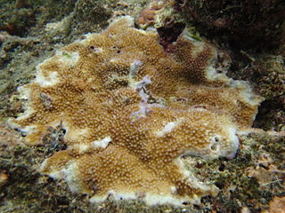
Acropora palmerae is a species of acroporid coral found in the northern Indian Ocean, the central Indo-Pacific, Australia, Southeast Asia, Japan, the East China Sea and the oceanic west Pacific Ocean. It is also found in Palau and the Mariana Islands, American Samoa, the Andaman Islands, the Great Barrier Reef, Okinawa Island, Mauritius, Micronesia, the Cook Islands and the Philippines. It occurs in tropical shallow reefs on flats exposed the action of strong waves and in lagoons, from depths of 0 to 12 metres. It was described by Wells in 1954.
Coordinates: 7°17′06″N134°17′01″E / 7.284945°N 134.283624°E
| Rock Islands | ||
|---|---|---|
| Bodies of water & reefs | ||
| Cities, towns & villages | ||
| Buildings and structures | ||
| | This Palau location article is a stub. You can help Wikipedia by expanding it. |