Rockwood, Michigan

Last updated
Rockwood, Michigan
City of Rockwood
Rockwood City Hall, MI.jpg
Rockwood City Hall and Fire Department
Location of Rockwood, Michigan in Wayne County.svg
Location within Wayne County
USA Michigan location map.svg
Red pog.svg
Rockwood
Location within the state of Michigan
Usa edcp location map.svg
Red pog.svg
Rockwood
Location within the United States
Coordinates: 42°04′20″N83°14′40″W / 42.07222°N 83.24444°W / 42.07222; -83.24444
Country Flag of the United States.svg United States
State Flag of Michigan.svg  Michigan
County Wayne
Established1861
Government
   Mayor Troy Cox
Area
[1]
   City 2.70 sq mi (7.00 km2)
  Land2.52 sq mi (6.53 km2)
  Water0.18 sq mi (0.47 km2)
Elevation
584 ft (178 m)
Population
 (2020)
   City 3,240
  Density1,284.69/sq mi (496.08/km2)
   Metro
4,285,832 (Metro Detroit)
Time zone UTC-5 (EST)
  Summer (DST) UTC-4 (EDT)
ZIP code(s)
48173
Area code 734
FIPS code 26-69180 [2]
GNIS feature ID0636095 [3]
Website rockwoodmi.org

Rockwood is a city in southeastern Wayne County in the U.S. state of Michigan. The population was 3,289 at the 2010 census. [4]

Contents

Geography

According to the United States Census Bureau, the city has a total area of 2.65 square miles (6.86 km2), of which 2.52 square miles (6.53 km2) is land and 0.13 square miles (0.34 km2) is water. [5]

Demographics

Historical population
CensusPop.Note
1930 953
1940 1,14720.4%
1950 1,044−9.0%
1960 2,02694.1%
1970 3,22559.2%
1980 3,3463.8%
1990 3,141−6.1%
2000 3,4429.6%
2010 3,289−4.4%
2020 3,240−1.5%
U.S. Decennial Census [6]

2010 census

As of the census [7] of 2010, there were 3,289 people, 1,295 households, and 900 families living in the city. The population density was 1,305.2 inhabitants per square mile (503.9/km2). There were 1,387 housing units at an average density of 550.4 per square mile (212.5/km2). The racial makeup of the city was 94.6% White, 1.7% African American, 0.9% Native American, 0.9% Asian, 0.4% from other races, and 1.5% from two or more races. Hispanic or Latino of any race were 2.7% of the population.

There were 1,295 households, of which 32.1% had children under the age of 18 living with them, 52.0% were married couples living together, 12.4% had a female householder with no husband present, 5.1% had a male householder with no wife present, and 30.5% were non-families. 25.9% of all households were made up of individuals, and 8.6% had someone living alone who was 65 years of age or older. The average household size was 2.52 and the average family size was 3.04.

The median age in the city was 40.9 years. 23% of residents were under the age of 18; 8.4% were between the ages of 18 and 24; 24.7% were from 25 to 44; 31.8% were from 45 to 64; and 12% were 65 years of age or older. The gender makeup of the city was 50.1% male and 49.9% female.

2000 census

As of the census [2] of 2000, there were 3,442 people, 1,318 households, and 929 families living in the city. The population density was 1,272.9 inhabitants per square mile (491.5/km2). There were 1,353 housing units at an average density of 500.3 per square mile (193.2/km2). The racial makeup of the city was 95.64% White, 0.64% African American, 0.99% Native American, 0.61% Asian, 0.96% from other races, and 1.16% from two or more races. Hispanic or Latino of any race were 2.53% of the population.

There were 1,318 households, out of which 33.4% had children under the age of 18 living with them, 55.8% were married couples living together, 10.2% had a female householder with no husband present, and 29.5% were non-families. 24.2% of all households were made up of individuals, and 8.2% had someone living alone who was 65 years of age or older. The average household size was 2.60 and the average family size was 3.10.

In the city, the population was spread out, with 24.7% under the age of 18, 9.6% from 18 to 24, 30.1% from 25 to 44, 26.2% from 45 to 64, and 9.4% who were 65 years of age or older. The median age was 36 years. For every 100 females, there were 103.4 males. For every 100 females age 18 and over, there were 101.2 males.

The median income for a household in the city was $55,987, and the median income for a family was $59,677. Males had a median income of $51,977 versus $30,684 for females. The per capita income for the city was $23,563. About 2.3% of families and 4.0% of the population were below the poverty line, including 3.7% of those under age 18 and none of those age 65 or over.

Government

Rockwood uses a city council consisting of seven council members including the mayor. As of March 2020, the current mayor is Daniel G. Guzzi. [8]

Education

Rockwood is in the Gibraltar School District. [9] [10]

Related Research Articles

<span class="mw-page-title-main">Diaz, Arkansas</span> City in Arkansas, United States

Diaz is a city in Jackson County, Arkansas, United States. The population was 1,318 at the 2010 census.

<span class="mw-page-title-main">Vineyards, Florida</span> Census-designated place in Florida, United States

Vineyards is a census-designated place (CDP) in Collier County, Florida, United States. The population was 3,883 at the 2020 census. It is part of the Naples–Marco Island Metropolitan Statistical Area.

<span class="mw-page-title-main">Mango, Florida</span> Census-designated place in Florida, United States

Mango is a census-designated place (CDP) in Hillsborough County, Florida, United States. The population was 12,699 at 2020 census, up from the 11,313 at the 2010 census.

<span class="mw-page-title-main">Ossian, Indiana</span> Town in Indiana, United States

Ossian is a town in Jefferson Township, Wells County, in the U.S. state of Indiana. The town was named after Ossian, the narrator of a cycle of epic poems by the Scottish poet James Macpherson. The population was 3,289 at the 2010 census.

<span class="mw-page-title-main">Walford, Iowa</span> City in Iowa, United States

Walford is a city in Benton and Linn counties in the U.S. state of Iowa. The population was 1,366 at the time of the 2020 census. It is part of the Cedar Rapids Metropolitan Statistical Area.

<span class="mw-page-title-main">Jesup, Iowa</span> City in Iowa, United States

Jesup is a city in Buchanan County and partly in Black Hawk County in the U.S. state of Iowa. The population was 2,508 at the time of the 2020 census. It was named for Morris Ketchum Jesup, president of the Dubuque and Sioux City Railroad.

<span class="mw-page-title-main">St. John, Kansas</span> City in Stafford County, Kansas

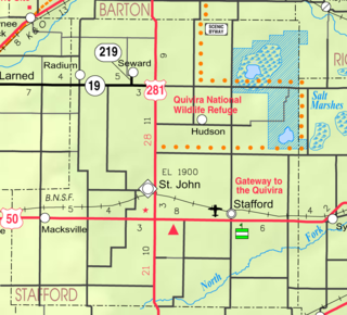
St. John is a city in and the county seat of Stafford County, Kansas, United States. As of the 2020 census, the population of the city was 1,228.

<span class="mw-page-title-main">Flat Rock, Michigan</span> City in Michigan, United States

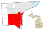
Flat Rock is a city in Wayne County, Michigan, United States, with a small portion of the city extending into Monroe County. At the 2020 census, the population was 10,541.

<span class="mw-page-title-main">Gibraltar, Michigan</span> City in Michigan, United States

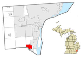
Gibraltar is a city in Wayne County in the U.S. state of Michigan. The population was 4,656 at the 2010 census.

<span class="mw-page-title-main">Fairfax, Minnesota</span> City in Minnesota, United States

Fairfax is a city in Renville County, Minnesota, United States. The population was 1,235 at the 2010 census.

Rockwood Township is a township in Wadena County, Minnesota, United States, not to be confused with Rockwood Township, Hubbard County, Minnesota. The population was 390 at the 2010 census.

Monticello Township is a township in Wright County, Minnesota, United States. The population was 4,139 at the 2000 census.

<span class="mw-page-title-main">Hayti, Missouri</span> City in Missouri, United States

Hayti is a city in eastern Pemiscot County, Missouri, United States. The population was 2,493 at the 2020 census.

<span class="mw-page-title-main">Woodbridge (CDP), New Jersey</span> Populated place in Middlesex County, New Jersey, US

Woodbridge is an unincorporated community and census-designated place (CDP) within Woodbridge Township, in Middlesex County, in the U.S. state of New Jersey. As of the 2010 United States Census, the CDP's population was 19,265. Despite the similarity in the name of the CDP and the township, the two are not coextensive; the CDP occupies 15.7% of the township's 24.51 square miles (63.5 km2).

Perth is a town in Fulton County, New York, United States. The population was 3,646 at the 2010 census. It is in the southeastern corner of the county, north of Amsterdam. The town is named after Perth, Scotland.

<span class="mw-page-title-main">Washington Heights, New York</span> CDP in New York, United States

Washington Heights is a census-designated place (CDP) in Orange County, New York, United States. The population was 2,205 at the 2020 census.

<span class="mw-page-title-main">Harrisburg, Oregon</span> City in Oregon, United States

Harrisburg is a city in Linn County, Oregon, United States. The population was 3,567 at the 2010 census.

<span class="mw-page-title-main">Edgewood, Northumberland County, Pennsylvania</span> CDP in Pennsylvania, United States

Edgewood is a census-designated place (CDP) located in Coal Township, in Northumberland County, Pennsylvania, United States. The population was 2,619 at the 2000 census.

<span class="mw-page-title-main">Sister Bay, Wisconsin</span> Village in Wisconsin, United States

Sister Bay is a village in Door County, Wisconsin, United States. The population was 876 at the 2010 census.

<span class="mw-page-title-main">Eagle Butte, South Dakota</span> City in South Dakota, United States

Eagle Butte is a city in Dewey and Ziebach counties in South Dakota, United States. The population was 1,258 at the 2020 census. It is adjacent to the North Eagle Butte CDP.

References

  1. "2020 U.S. Gazetteer Files". United States Census Bureau. Retrieved May 21, 2022.
  2. 1 2 "U.S. Census website". United States Census Bureau . Retrieved 2008-01-31.
  3. "US Board on Geographic Names". United States Geological Survey. 2007-10-25. Retrieved 2008-01-31.
  4. "Race, Hispanic or Latino, Age, and Housing Occupancy: 2010 Census Redistricting Data (Public Law 94-171) Summary File (QT-PL), Rockwood city, Michigan". United States Census Bureau . Retrieved September 7, 2011.
  5. "US Gazetteer files 2010". United States Census Bureau. Archived from the original on 2012-07-02. Retrieved 2012-11-25.
  6. "Census of Population and Housing". Census.gov. Retrieved June 4, 2015.
  7. "U.S. Census website". United States Census Bureau . Retrieved 2012-11-25.
  8. "City of Rockwood - Council Chambers - Council Members". City of Rockwood. Retrieved March 27, 2020.
  9. "Gibraltar District Map" (Archive). Gibraltar School District. Retrieved on June 15, 2014.
  10. "SCHOOL DISTRICT REFERENCE MAP (2010 CENSUS): Wayne County, MI" (DC10SD_C26163_001.pdf) (Archive). U.S. Census Bureau. Retrieved on June 15, 2014.