Hampden County is a non-governmental county located in the Pioneer Valley of the U.S. state of Massachusetts, in the United States. As of the 2020 census, Hampden County's population was 465,825. Its traditional county seat is Springfield, the Connecticut River Valley's largest city, and economic and cultural capital; with an estimated population of 154,758, approximately one-third of Hampden County residents live in Springfield.

Becket is a town in Berkshire County, Massachusetts, United States. It is part of the Pittsfield, Massachusetts Metropolitan Statistical Area. The population was 1,931 at the 2020 census.

Otis is a town in Berkshire County, Massachusetts, United States. It is part of the Pittsfield, Massachusetts, Metropolitan Statistical Area. The population was 1,634 at the 2020 census.

Washington is a town in Berkshire County, Massachusetts, United States. It is part of the Pittsfield, Massachusetts, Metropolitan Statistical Area. The population was 494 at the 2020 census.

Blandford is a town in Hampden County, Massachusetts, United States. The population was 1,215 at the 2020 census. It is part of the Springfield, Massachusetts Metropolitan Statistical Area. It was the home of the Blandford Ski Area.

Chester is a town in Hampden County, Massachusetts, United States, situated in Western Massachusetts. It is part of the Springfield metropolitan statistical area. The town includes the Chester Factory Village Historic District. The total population was 1,228 in the 2020 census.
Monson Center is a census-designated place (CDP) in the town of Monson in Hampden County, Massachusetts, United States. The population was 2,107 at the 2010 census, out of a total 8,560 people in the town. It is part of the Springfield, Massachusetts Metropolitan Statistical Area.

Montgomery is a town in Hampden County, Massachusetts, United States. The population was 819 at the 2020 census. It is part of the Springfield, Massachusetts Metropolitan Statistical Area.

Russell is a town in Hampden County, Massachusetts, United States. The population was 1,643 at the 2020 census. It is part of the Springfield, Massachusetts Metropolitan Statistical Area.

Westfield is a city in Hampden County, in the Pioneer Valley of western Massachusetts, United States. Westfield was first settled by Europeans in 1660. It is part of the Springfield, Massachusetts Metropolitan Statistical Area. The population was 40,834 at the 2020 census.

Chesterfield is a rural hill town in Hampshire County, Massachusetts, United States, 26 miles (42 km) east of Pittsfield and 90 miles (140 km) west of Boston. The population was 1,186 at the 2020 census. It is part of the Springfield, Massachusetts Metropolitan Statistical Area.

Huntington is a town in Hampshire County, Massachusetts, United States. The population was 2,094 at the 2020 census. It is part of the Springfield, Massachusetts Metropolitan Statistical Area.

Wilbraham is a census-designated place (CDP) in the town of Wilbraham in Hampden County, Massachusetts, United States. The population was 3,915 at the 2010 census, out of 14,868 in the town as a whole. It is part of the Springfield, Massachusetts Metropolitan Statistical Area.
Belchertown is a census-designated place (CDP) comprising the central village in the town of Belchertown in Hampshire County, Massachusetts, United States. The population was 2,899 at the 2010 census, out of a total town population of 14,649. It is part of the Springfield, Massachusetts Metropolitan Statistical Area.

Granby is a census-designated place (CDP) comprising the main village in the town of Granby in Hampshire County, Massachusetts, United States. The population of the CDP was 1,368 at the 2010 census, out of a total town population of 6,240. It is part of the Springfield, Massachusetts Metropolitan Statistical Area.

Hatfield is a census-designated place (CDP) comprising the main village in the town of Hatfield in Hampshire County, Massachusetts, United States. The population of the CDP was 1,318 at the 2010 census, out of a total town population of 3,279. It is part of the Springfield, Massachusetts Metropolitan Statistical Area.

Ware is a census-designated place (CDP) comprising the main village in the town of Ware in Hampshire County, Massachusetts, United States. The population of the CDP was 6,170 at the 2010 census, out of a total town population of 9,872. It is part of the Springfield, Massachusetts Metropolitan Statistical Area.
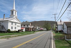
Blandford is a census-designated place that comprises the populated center of the town of Blandford in Hampden County, Massachusetts, United States. The population of the CDP was 393 at the 2010 census, out of 1,233 in the entire town of Blandford. It is part of the Springfield, Massachusetts Metropolitan Statistical Area.

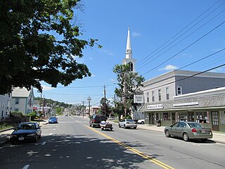
Chester is a census-designated place that comprises the populated center of the town of Chester in Hampden County, Massachusetts, United States. The population of the CDP was 627 at the 2010 census, out of 1,337 in the entire town of Chester. It is part of the Springfield, Massachusetts Metropolitan Statistical Area.

Huntington is a census-designated place (CDP) comprising the main village in the town of Huntington in Hampshire County, Massachusetts, United States. The population of the CDP was 936 at the 2010 census, out of a total town population of 2,180. It is part of the Springfield, Massachusetts Metropolitan Statistical Area.