Salt road

Last updated
Sign for historic salt road in Bavaria Salzstrasse Beschilderung.jpg
Sign for historic salt road in Bavaria

A salt road (also known as a salt route, salt way, saltway, or salt trading route) refers to any of the prehistoric and historical trade routes by which essential salt was transported to regions that lacked it.

Contents

From the Bronze Age (in the 2nd millennium BC) fixed transhumance routes appeared, like the Ligurian drailles that linked the maritime Liguria with the alpages, long before any purposely-constructed roadways formed the overland routes by which salt-rich provinces supplied salt-starved ones.

Roads

The Via Salaria , an ancient Roman road in Italy, eventually ran from Rome (from Porta Salaria in the Aurelian Walls) to Castrum Truentinum (Porto d'Ascoli) on the Adriatic coast - a distance of 242 kilometres (150 mi). A modern road by this name, part of the SS4 highway, runs 51 kilometres (32 mi) from Rome to Osteria Nuova in Orvieto.

The Old Salt Route, about 100 kilometres (62 mi), was a medieval route in northern Germany, linking Lüneburg (in Lower Saxony) with the port of Lübeck (in Schleswig-Holstein), which required more salt than it could produce itself. Lüneburg, first mentioned in the 10th century, grew rich on the salterns surrounding the town. Traders shipped salt via Lauenburg to Lübeck, which supplied all the coasts of the Baltic Sea. Lüneburg and its salt were major factors of power and wealth of the Hanseatic League. After a long period of prosperity, its importance declined after 1600. The last of the salt mines was closed in 1980, ending the thousand-year tradition.

In medieval Bosnia, via Narenta was used as a trade route between Podvisoki and Dubrovnik. It is recorded that 600 horses delivered around 1500 modius of salt to Podvisoki. [1]

In France, the salt route was longer than a portage between navigable streams. Salt unloaded at the ports of Nice and Ventimiglia could travel by two salt roads leading away from the coastal area, from Nice up the Vésubie valley, via Saint-Martin-Vésubie at the head of the valley, or from Ventimiglia inland through the Roya Valley, over the Col de Tende pass and into Piedmont.

A camel train for salt transportation in Afar Region of Ethiopia ET Afar asv2018-01 img08 Lake Karum area.jpg
A camel train for salt transportation in Afar Region of Ethiopia

In Ethiopia blocks of salt, called amoleh , were carved from the salt pans of the Afar Depression, especially around Lake Afrera, then carried by camel west to Atsbi and Ficho in the highland, whence traders distributed them throughout the rest of Ethiopia, as far south as the Kingdom of Kaffa. [2]

Before the People's Republic of China annexed Tibet and closed the borders in the 1950s, salt trade between Nepal and Tibet crossed passes through the Himalayas such as the gorges of the upper Karnali and Gandaki rivers. Caravans of pack animals brought rice up from Nepal's Terai and lower hills in exchange for salt from dry lakes on the Tibetan Plateau.

In the United Kingdom an ancient road known as the Salt Way runs from Droitwich Spa, passing Banbury and onto Princes Risborough. [3] The Salt Way is managed by the Salt Way Activity Group. [4]

The Vienna Road, later also known as Southern Railway (Austria) that succeeded the road as a railway connection between Vienna and Trieste, was a salt road connecting the two cities via Graz, Maribor and Ljubljana. While salt was not the primary good traded on this road (roughly 7% of the trade), [5] the historic salt connection is a significant part of Slovenian culture and tradition due to a folk hero Martin Krpan - a story based on oral tradition taking place on the Vienna Road.

In medieval Japan, the landlocked and mountainous Shinano Province was supplied with salt by two routes collectively called Shio no Michi. [6]

Rivers and ports

The salt highways of Europe were the navigable rivers, where by medieval times shipments of salt coming upstream passed rafts and log-trains of timber, which could only be shipped downstream. [7] And even along Europe's coasts, once long-distance trade was revived in the 11th century, the hot and sunny south naturally outproduced the wet north. By the Late Middle Ages, the expanding fishing fleets of the Low Countries required more salt than could be produced locally; the balance was made up with salt from the Iberian Peninsula. "The United Provinces could have been brought to their knees if their supplies of salt had been blocked at the end of the sixteenth century. Spain did no more than dream of this," Fernand Braudel has written. [8] In Ming China, salt as well as rice was shipped from south to north, along the Imperial Canal as far as Beijing.

Salterns and saltpans

In France, a major source of marine salt with access to expansive hinterlands in need of it was the wetlands region in Languedoc called the Camargue; from the salt pans called salines, convoys of boatloads of salt could be carried up the Rhone to Seyssel where it had to be off-loaded and carried by mule train inland to the little village of Regonfle near Geneva, where it rejoined a waterway. [9]

Of the early modern period in Europe, Fernand Braudel remarked that in spite of the flux and reflux of economics:

"no salt mine was ever abandoned and the scale of the equipment needed put these mines in the hands of merchants from very early days. Salt-marshes on the other hand, were exploited by artisanal methods: the merchants took control only of transport and marketing, both in Setúbal in Portugal and in Peccais in Languedoc. Salt marketing was probably quite big business along the Atlantic seabord [10] or the Rhône valley." [11]

The vast interior of Poland was salt-starved, its maritime districts lying under rainy skies and fronting the Baltic Sea. By medieval times the process of mining for fossil salt supplemented the age-old techniques of evaporating sea salt in tidal pans. By the 14th century, at Wieliczka near Kraków, Braudel reports that peasant extraction of salt from brine evaporated in large shallow iron pans had been eliminated by the early industrialisation of salt mining. "Galleries and shafts were now dug to a depth of 300 metres, and enormous winches powered by teams of horses brought blocks of salt to the surface. At its peak, production stood at 40,000 tons a year and the mines employed 3,000 workers. By 1368, the cooperation of the Polish state had been obtained." [12]

Since pre-Inca times, salt has been obtained in Maras, Peru, by evaporating salty water from a local subterranean stream.

See also

Related Research Articles

<span class="mw-page-title-main">Old Salt Route</span> Medieval trade route in northern Europe

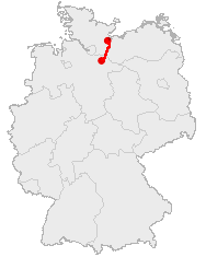
The Old Salt Route was a medieval trade route in Northern Germany, one of the ancient network of salt roads which were used primarily for the transport of salt and other staples. In Germany it was referred to as Alte Salzstraße.

<span class="mw-page-title-main">Lüneburg</span> Town in Lower Saxony, Germany

Lüneburg, officially the Hanseatic City of Lüneburg and also known in English as Lunenburg, is a town in the German state of Lower Saxony. It is located about 50 km (31 mi) southeast of another Hanseatic city, Hamburg, and belongs to that city's wider metropolitan region. The capital of the district which bears its name, it is home to roughly 77,000 people. Lüneburg's urban area, which includes the surrounding communities of Adendorf, Bardowick, Barendorf and Reppenstedt, has a population of around 103,000. Lüneburg has been allowed to use the title "Hansestadt" in its name since 2007, in recognition of its membership in the former Hanseatic League. Lüneburg is also home to Leuphana University.

<span class="mw-page-title-main">Adal Sultanate</span> 1415–1577 Muslim sultanate in the Horn of Africa

The Adal Sultanate also known as the Adal Empire, or Bar Saʿad dīn was a medieval Sunni Muslim Empire which was located in the Horn of Africa. It was founded by Sabr ad-Din III on the Harar plateau in Adal after the fall of the Sultanate of Ifat. The kingdom flourished c. 1415 to 1577. At its height, the polity under Sultan Badlay controlled the territory stretching from Cape Guardafui in Somalia to the port city of Suakin in Sudan. The Adal Empire maintained a robust commercial and political relationship with the Ottoman Empire. Sultanate of Adal was alternatively known as the federation of Zeila.

<span class="mw-page-title-main">Adwa</span> Town in Tigray Region, Ethiopia

Adwa is a town and separate woreda in Tigray Region, Ethiopia. It is best known as the community closest to the site of the 1896 Battle of Adwa, in which Ethiopian soldiers defeated Italian troops, thus being one of the few African nations to thwart European colonialism. Located in the Central Zone of the Tigray Region, Adwa has a longitude and latitude of 14°10′N38°54′E, and an elevation of 1907 meters. Adwa is surrounded by Adwa woreda.

<span class="mw-page-title-main">Roanne</span> Subprefecture and commune in Auvergne-Rhône-Alpes, France

Roanne is a commune in the Loire department, central France.

<span class="mw-page-title-main">Assab</span> Port city in Southern Red Sea Region, Eritrea

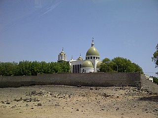
Assab or Aseb is a port city in the Southern Red Sea Region of Eritrea. It is situated on the west coast of the Red Sea. Languages spoken in Assab are predominantly Afar,Amarigna Tigrinya, and Arabic. After the Italian government took control of the port in 1882, it laid the foundations for the formation of the colony of Italian Eritrea, which became the independent country of Eritrea following its independence from Ethiopia in the 1990s.

<span class="mw-page-title-main">Salt evaporation pond</span> Shallow artificial pond designed to extract salts from sea water or other brines,

A salt evaporation pond is a shallow artificial salt pan designed to extract salts from sea water or other brines. The salt pans are shallow and expansive, allowing sunlight to penetrate and reach the seawater. Natural salt pans are formed through geologic processes, where evaporating water leaves behind salt deposits. Some salt evaporation ponds are only slightly modified from their natural version, such as the ponds on Great Inagua in the Bahamas, or the ponds in Jasiira, a few kilometres south of Mogadishu, where seawater is trapped and left to evaporate in the sun.

<span class="mw-page-title-main">Trans-Saharan trade</span> Trade between sub-Saharan Africa and North Africa

Trans-Saharan trade is trade between sub-Saharan Africa and North Africa that requires travel across the Sahara. Though this trade began in prehistoric times, the peak of trade extended from the 8th century until the early 17th century CE. The Sahara once had a different climate and environment. In Libya and Algeria, from at least 7000 BCE, pastoralism, large settlements and pottery were present. Cattle were introduced to the Central Sahara (Ahaggar) between 4090 to 3500 BCE. Remarkable rock paintings in arid regions portray flora and fauna that are not present in the modern desert.

<span class="mw-page-title-main">History of salt</span> Role in human culture

Salt, also referred to as table salt or by its chemical formula NaCl, is an ionic compound made of sodium and chloride ions. All life depends on its chemical properties to survive. It has been used by humans for thousands of years, from food preservation to seasoning. Salt's ability to preserve food was a founding contributor to the development of civilization. It helped eliminate dependence on seasonal availability of food, and made it possible to transport food over large distances. However, salt was often difficult to obtain, so it was a highly valued trade item, and was considered a form of currency by certain people. Many salt roads, such as the Via Salaria in Italy, had been established by the Bronze Age.

<span class="mw-page-title-main">Tadjoura</span> Town in Djibouti

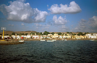
Tadjoura is one of the oldest towns in Djibouti and the capital of the Tadjourah Region. The town rose to prominence in the early 19th century as an alterative port to nearby Zeila. Lying on the Gulf of Tadjoura, it is home to a population of around 45,000 inhabitants. It is the third-largest city in the country after Djibouti and Ali Sabieh.

<span class="mw-page-title-main">Leintz Gatzaga</span> Municipality in Basque Country, Spain

Leintz Gatzaga is a town located in the province of Gipuzkoa, in the Autonomous Community of Basque Country, northern Spain. The municipality's population is 251 (2015).

<span class="mw-page-title-main">Tende</span> Commune in Provence-Alpes-Côte dAzur, France

Tende is a commune in the Alpes-Maritimes department in southeastern France.

<span class="mw-page-title-main">Open-pan salt making</span> Brine derivative

Open-pan salt making is a method of salt production wherein salt is extracted from brine using open pans.

<span class="mw-page-title-main">Debarq</span> Place in Amhara, Ethiopia

Debarq also spelled Dabareq and Debark, is a town in northern Ethiopia, 90 kilometers north-east of Gondar on the highway between Gondar and Axum, and is in the Semien Gondar Zone of the Amhara Region. It has a latitude and longitude of 13°08′N37°54′E and an elevation of 2850 meters above sea level.

<span class="mw-page-title-main">Caravan (travellers)</span> Group of people or animals traveling together in a row

A caravan or cafila is a group of people traveling together, often on a trade expedition. Caravans were used mainly in desert areas and throughout the Silk Road, where traveling in groups aided in defense against bandits as well as helped to improve economies of scale in trade. Some of the first caravans on the Silk Road were sent out by Emperor Wu of Han in the 2nd century BCE when this vast network of roads was 'born', and as China began exporting large quantities of silk and other goods west, particularly destined for the Roman Empire.

<span class="mw-page-title-main">Champagne fairs</span>

The Champagne fairs were an annual cycle of trade fairs which flourished in different towns of the County of Champagne in Northeastern France in the 12th and 13th centuries, originating in local agricultural and stock fairs. Each fair lasted about 2 to 3 weeks. The Champagne fairs, sited on ancient land routes and largely self-regulated through the development of the Lex mercatoria, became an important engine in the reviving economic history of medieval Europe, "veritable nerve centers" serving as a premier market for textiles, leather, fur, and spices. At their height, in the late 12th and the 13th century, the fairs linked the cloth-producing cities of the Low Countries with the Italian dyeing and exporting centers, with Genoa in the lead, dominating the commercial and banking relations operating at the frontier region between the north and the Mediterranean. The Champagne fairs were one of the earliest manifestations of a linked European economy, a characteristic of the High Middle Ages.

ʿAydhab was an important medieval port on the west coast of the Red Sea. The abandoned site of the town is located in the Halaib Triangle, a territory disputed between Egypt and the Sudan.

<span class="mw-page-title-main">Slavery in Ethiopia</span>

Slavery in Ethiopia existed for centuries, going as far back as 1495 BC and ending in 1942. There are also sources indicating the export of slaves from the Aksumite Empire. The practice formed an integral part of Ethiopian society. Slaves were traditionally drawn from the Nilotic groups inhabiting Ethiopia's southern hinterland and Oromos. War captives were another source of slaves, though the perception, treatment and duties of these prisoners was markedly different. Although religious law banned Christian slave masters from taking part in the slave trade, many Muslim Ethiopian slave traders took part in the Arab slave trade. Slaves usually served as concubines, bodyguards, servants and treasurers.

<span class="mw-page-title-main">Matsumoto Kaidō</span>

The Matsumoto Kaidō (松本街道), also known as the Chikuni Kaidō (千国街道), the Itoigawa Kaidō (糸魚川街道) or simply as the Shio-no-michi (塩の道) was a secondary road in pre-modern Japan, connecting Matsumoto in Shinano Province with Itoigawa in Echigo Province). In the year 2002, a well-preserved 20-kilometer section of the original path in the city of Itoigawa was designated a National Historic Site of Japan, and an additional 10-kilometer section was added in 2007.

The economy of the Ethiopian Empire was dominated by the barter system, traditionally composed of Arab and Ethiopian Muslim caravans, and a strong trade culture nourished business within the feudal system. In medieval times, neighboring state Emirate of Harar became the center of commerce while imports and exports passed through the port of Zeila, operated by Muslim merchants, delivering commodities to the Abyssinians through Aliyu Amba a town in Ifat, which connected the Shewa.

References

Notes

  1. Renuntiando” (9. August 1428), State archive, Ragusa Republic, Series: Diversa Cancellariae, Number: XLV, Foil: 31 verso.
  2. Pankhurst (1968) , pp. 461ff.
  3. "The hundred of Banbury | British History Online". www.british-history.ac.uk. Archived from the original on 2020-06-16. Retrieved 2020-05-12.
  4. "Salt Way Activity Group | Preserving the Salt Way". www.saltwayactivitygroup.org.uk. Archived from the original on 2020-08-09. Retrieved 2020-05-12.
  5. Kosi, Miha (January 1998). Potujoči srednji vek: Cesta, popotnik in promet na Slovenskem med antiko in 16. Stoletjem. p. 306. ISBN   9789616182669. Archived from the original on 2023-09-16. Retrieved 2021-12-30.
  6. Shio no Michi wo Tabi Suru Archived 2007-11-28 at the Wayback Machine . (in Japanese) Salt Road Museum. Accessed December 20, 2007.
  7. In the tenth century along an established salt road mule trains brought firewood from the Rouergue to the deforested Mediterranean ports and returned laden with salt.
  8. Braudel (1982) , p. 178.
  9. Braudel (1982) , p. 353.
  10. Brouage and Bourgneuf were specialised in the mass production of sea salt, according to Braudel (1984) , p. 208.
  11. Braudel (1982) , pp. 327f.
  12. Braudel (1982) , p. 322.

Bibliography

  • Braudel, Fernand (1982). The Wheels of Commerce. Civilisation and Capitalism 15th–18th Century. Vol. II. New York: Harper & Row.
  • Braudel, Fernand (1984). The Perspective of the World. Civilisation and Capitalism. Vol. III. New York: Harper & Row.
  • Pankhurst, Richard K. P. (1968). Economic History of Ethiopia. Addis Ababa: Haile Selassie I University.