Ghaghara

Last updated

Karnali
Karnali
Sarayu
Mapcha Tsangpo
Karnali river.JPG
Karnali river in Nepal
River Ganges and tributaries.png
Map showing the Karnali, Ghaghara and Gandaki tributaries of the Ganges
Location
Country China (Tibet Autonomous Region), Nepal, India
Physical characteristics
SourceMapchachungo Glacier
  location Tibet , China
  elevation3,962 m (12,999 ft)
Mouth Ganges
  location
Revelganj, Bihar, India
  coordinates
25°45′11″N84°39′59″E / 25.75306°N 84.66639°E / 25.75306; 84.66639
Length1,080 km (670 mi)
Basin size127,950 km2 (49,400 sq mi)
Discharge 
  average2,990 m3/s (106,000 cu ft/s)
Discharge 
  locationNepal
  average1,369 m3/s (48,300 cu ft/s)
Basin features
Tributaries 
  left Bheri, Kuwana, Rapti, Chhoti Gandak
  right Seti, Dahawar, Sarda, Budhi Ganga

The Karnali River, called Ghaghara River in India, Mapcha Tsangpo in Tibet, and the lower Ghaghara in Awadh called Sarayu River, [1] is a perennial trans-boundary river that originates in the northern slopes of the Himalayas in the Tibetan Plateau, cuts through the Himalayas in Nepal and joins the Sharda River at Brahmaghat in India. Together they form the Ghaghara River, a major left-bank tributary of the Ganges. With a length of 507 km (315 mi), it is the longest river in Nepal. The total length of the Ghaghara up to its confluence with the Ganges at Revelganj in Bihar is 1,080 km (670 mi). [2] It is the largest tributary of the Ganges by volume and the second largest by length after Yamuna.

Contents

Course

Source of Karnali River Lake Manasarovar.jpg
Source of Karnali River
Ghaghara River in Ayodhya is also known as Saryu river Saryu.JPG
Ghaghara River in Ayodhya is also known as Saryu river
Lake Manasarovar in Tibet near the source of the Karnali River Mansarovar.jpg
Lake Manasarovar in Tibet near the source of the Karnali River

The Karnali rises in the northern slopes of the Himalayas in Tibet, in the glaciers of Mapchachungo, at an elevation of about 3,962 metres (12,999 ft) above sea level. The river flows south through one of the most remote and least explored areas of Nepal as the Karnali River. The 202-kilometre (126 mi) Seti River drains the western part of the catchment and joins the Karnali River in Doti District north of Dundras hill. Another tributary, the 264-kilometre (164 mi) long Bheri, rises in the western part of Dhaulagiri Himalaya and drains the eastern part of the catchment, meeting the Karnali near Kuineghat in Surkhet. [3]

Cutting southward across the Sivalik Hills, it splits into two branches, the Geruwa on the left and Kauriala river on the right near Chisapani to rejoin south of the Indian border and form the proper Ghaghara. Other tributaries originating in Nepal are the West Rapti, the Kali (or Mahakali) and the little Gandak. It flows southeast through Uttar Pradesh and Bihar states to join the Ganges downstream of the town of Chhapra, after a course of 1,080 kilometres (670 mi). Saryu river is stated to be synonymous with the modern Karnali river or as a tributary of it.

Karnali River exposes the oldest part of the Sivalik Hills of Nepal. The remnant magnetization of siltstones and sandstones in this group suggests a depositional age of between 16 million and 5.2 million years. [4]

Basin

Ghaghra river in Sitapur Ghaghra river in Sitapur.jpg
Ghaghra river in Sitapur

The Karnali River Basin lies between the mountain ranges of Dhaulagiri in Nepal and Nanda Devi in Uttarakhand. Dhaulagiri II, elevation 7,751 metres (25,430 ft), is the highest point of the entire basin. In the north, it lies in the rain shadow of the Himalayas. The basin formed by the river has a total catchment area of 127,950 square kilometres (49,400 sq mi), of which 45 percent is in India. [5]

Tributaries

Chhoti Gandak is a groundwater-fed meandering river originating near Dhesopool, Maharajganj district of Uttar Pradesh. It travels a distance of about 250 kilometres (160 mi) and joins Ghaghara near Guthani, Siwan district of Bihar. The Chhoti Gandak River Basin is located between 26°00' to 27°20' N latitude and 83°30' to 84°15' E longitude. Right bank tributaries are Khekhra, Hirna, Jethan, Maun, Duhari, Kanchi and Koilar rivers; Khanua river joins from the left bank. The discharge of Chhoti Gandak is mainly controlled by rain, which is very high during the monsoon season and low during the summers. It has been observed that whenever precipitation is high in the catchment areas, there is flood in the downstream part of the Chhoti Gandak River Basin. The region exhibits upland terrace surface, river valley terrace surface, present-day river channel with narrow flood plains, natural levee, and point-bar deposits. All these geomorphic features are depositional in nature and made up of alluvium of different ages. [6] [7] [8] [9]

The main tributaries of the Karnali are Seti and Bheri. [10]

Administrative zones and districts

In Nepal, the Karnali Province is the largest zone with about 5,000 square miles (13,000 km2) area. Its administrative center is Jumla. The zone is divided into the five districts of Dolpa, Humla, Jumla, Kalikot and Mugu. [11]

The Karnali Province has the lowest population density in Nepal. There are no large settlements on the banks of the river, which is only crossed near Chisapani by the Mahendra Highway. This region is now connected by karnali highway and now due to various hydro electricity projects this area is being developed. Now a 900 MW project is going to be constructed in this river

In India, the administrative districts in the Ghaghra catchment are Ambedkar Nagar, Ayodhya, Gonda, Azamgarh, Barabanki, Basti, Ballia, Bahraich, Deoria, Gonda, Gorakhpur, Sant Kabir Nagar, Lakhimpur Kheri, Mau, Sitapur of Uttar Pradesh and Siwan district in Bihar.

Important towns in India include Akabarpur, Ayodhya, Bahraich, Barabanki, Basti, Deoria, Barhalganj, Gonda, Gorakhpur, Sitapur, Siddharthnagar, Saint Kabir Nagar, Kamhariya, Rajesultanpur and Tanda in Uttar Pradesh and Chapra, Siwan, and Sonepur in Bihar.

The Ghaghra River is locally known as "Saryu" or "Sarayu" in the city of Ayodhya. [1]

Protected areas

Karnali River in Humla, Nepal Karnali-IMG 0138.jpg
Karnali River in Humla, Nepal
Karnali River in Nepal Karnali2.jpg
Karnali River in Nepal

Bardia National Park is the largest and most undisturbed protected area in the Karnali River basin, covering 968 km2 (374 sq mi) on the southern slopes of the Sivalik Hills. It is bordered in the south by the Babai River, and to the west by the Girwa River, a tributary of the Karnali. At Chisapani Gorge, the swift-flowing Karnali River emerges from the Shiwalik Range onto the broad plain and flows purposefully through the semi-tropical jungle. The park is famous for two Asian elephant herds, several deer species, gaur, nilgai, Himalayan tahr, serow and goral. The Karnali supports the endangered mugger crocodile, the gharial, a few remaining South Asian river dolphins and the golden mahseer.

Other protected areas include Katarniaghat Wildlife Sanctuary.

Endangered species

The Karnali provides the upper range for the Gangetic river dolphin (Platanista gangetica), the largest freshwater mammals found on the Indian subcontinent. They are considered vulnerable species under CITES Appendix 1 and are classified as endangered on the IUCN Red List (IUCN, 2004). The river dolphins are legally protected animals in Nepal as endangered mammal and fall under Schedule I of the protected list of National Parks & Wildlife Conservation Act, 1973. Living at the upstream range limit, dolphins in the Karnali River are particularly vulnerable to threats from habitat degradation. Dolphins need deep pools of water. They are often found in places where human activities are most intense and they are sometimes accidentally caught by the local people who live in the lower Karnali basin. The Karnali River supports the last potentially viable population of the Ganges river dolphin in Nepal. These dolphins are at their farthest upstream range and isolated by the Girijapur Barrage (a low gated dam), located about 16 kilometres (10 mi) downstream of the Nepal–India border. [12]

A high dam has been planned for some time just upstream of the dolphins' current (or at least recent) range in the Karnali River, Nepal. If built, this structure would almost certainly eliminate the small amount of dolphin habitat in Nepal's last river with a potentially viable dolphin population. Disturbance and environmental degradation associated with geotechnical feasibility studies and bridge and road construction for the dam already may have contributed to a decline in the number and range of dolphins or susu above the Nepal-India border. [13] The Ghaghara is the furthest upstream in the dolphin range.

Gangetic dolphin GangeticDolphin.jpg
Gangetic dolphin

Other important protected areas and their biological and religious significance are a) Khaptad NP at 2.25 square kilometres (0.87 sq mi), Dhorpatan HR at 13.25 square kilometres (5.12 sq mi), and WR (1976) at Kanchanpur at 3.05 square kilometres (1.18 sq mi) in the Terai Sal. [14]

Irrigation

India

The Sarda Sahayak Irrigation Project uses the combined flows from the rivers Ghaghara and Sarda in the Girija Barrage built across the Ghaghara river below a catchment area of 45,500 square kilometres (17,600 sq mi). This barrage is situated about 9 kilometres (6 mi) downstream of Khatria Ghat Rly station and 16 kilometres (10 mi) from the international border to Nepal in Bahraich district. It is linked to the Lower Sarda Barrage (built across the Sarda river, with a catchment area of 17,818 square kilometres (6,880 sq mi), about 28 kilometres (17 mi) northeast of Lakhimpur Kheri Rly station in Lakhimpur Kheri district) via a link canal from Girija Barrage to the Lower Sarda Barrage which is 28 kilometres (17 mi) long and is designed to divert a discharge of 480 cubic metres per second (17,000 cu ft/s) from Gandak to Sarda river.

The feeder channel taking off from the Lower Sarda Barrage is 258.8 kilometres (160.8 mi) long, feeds the five branches of Dariyabad, Barabani, Haideganj, RaeBareil and Purva, and is designed to carry a discharge of 765 cubic metres per second (27,000 cu ft/s). The Sarda Sahayak feeder channel meets the Haidergarh branch at 171 kilometres (106 mi) and Raibareli branch at 187 kilometres (116 mi). The entire canal system is considered the largest in Asia and designed to provide irrigation to a Culturalable Command Area (CCA) of 20,000 square kilometres (7,700 sq mi) covering 14 districts in 168 blocks with a gross command area of 40,000 square kilometres (15,000 sq mi).

On account of high silt flows during the flood season, Sarda Sahayak supplies (from Karnali) are suspended for 100 days between June and October, when the Lower Sarda Canal (feeder canal) draws water from the Sarda River, which is then flooded. [15]

In the past the Karnali River was considered to be attractive for the development of navigation right from the Indo–Nepal border to the confluence of this river and the Ganges. The lower reach of this river—called the Ghaghra in India—was used in the past for navigation by steamers. Apart from in the foothills of the Himalayas where most of the streams were simply fast-moving water throughout the greater part of the year and not navigable when flowing rapidly, most of the rivers with steadier currents had boats on them. The Ganges, the Ghaghra, the Yamuna, the Gomti, the Sharda and the Rapti were the most important navigable rivers in the Northwestern provinces and Oudh.[ citation needed ]

Many trade items such as timber, food grains, sugar, indigo, cotton seed, poppy seed and mustard seed were transported by boats. April, May and June were the most suitable months and were a busy trading period. Different kinds of cargo boats were used on the Ganges, the smaller ones were known as always, while the larger ones were known as Katris.[ citation needed ]

In the latter half of the 19th century when the railways came into existence, the significance of waterways as inland trade routes declined, as the railways were faster and safer. With the exception of eastern parts of Bengal where abundance of water in the natural network of channels sustained and continued to provide a suitable mode of transport of goods and people, the railways had almost entirely replaced the waterways as communication lines throughout the country by the end of the 19th century. [16]

The possibilities for further extension of the steamer services to the north had also been explored in the past. The Central Water and Power Commission of the Government of India had carried out hydrographical survey of the Karnali River from the Bahramghat to the confluence of this river and the Ganges a distance of 446 kilometres (277 mi). This survey was done in the years 1943–53 to explore the possibility of improvement and extension of navigation on this river by powered crafts. These surveys revealed that there were only 5 shoals under 90 centimetres (35 in) at low water between Burhaj and Bahramghat a distance of about 300 kilometres (190 mi). The minimum depth was 75 centimetres (30 in). These depths were available without any river conservancy works. All other conditions of navigable channel such as the width and current of flow etc. were also found to be very favourable. The low water stage in this river is only for a short duration. There is a great urgency to carry out detailed study of the Karnali river to develop modern inland waterway by applying various channel improvement technologies. [17]

See also

Related Research Articles

<span class="mw-page-title-main">Ganges</span> Major river in Asia

The Ganges is a trans-boundary river of Asia which flows through India and Bangladesh. The 2,525 km (1,569 mi) river rises in the western Himalayas in the Indian state of Uttarakhand. It flows south and east through the Gangetic plain of North India, receiving the right-bank tributary, the Yamuna, which also rises in the western Indian Himalayas, and several left-bank tributaries from Nepal that account for the bulk of its flow. In West Bengal state, India, a feeder canal taking off from its right bank diverts 50% of its flow southwards, artificially connecting it to the Hooghly River. The Ganges continues into Bangladesh, its name changing to the Padma. It is then joined by the Jamuna, the lower stream of the Brahmaputra, and eventually the Meghna, forming the major estuary of the Ganges Delta, and emptying into the Bay of Bengal. The Ganges–Brahmaputra–Meghna system is the second-largest river on earth by discharge.

<span class="mw-page-title-main">Geography of Nepal</span>

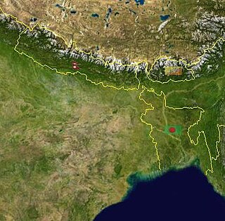
Nepal measures about 880 kilometers (547 mi) along its Himalayan axis by 150 to 250 kilometers across. It has an area of 147,516 km2 (56,956 sq mi).

<span class="mw-page-title-main">Yamuna</span> River in India

The Yamuna is the second-largest tributary river of the Ganges by discharge and the longest tributary in India. Originating from the Yamunotri Glacier at a height of about 4,500 m (14,800 ft) on the southwestern slopes of Bandarpunch peaks of the Lower Himalaya in Uttarakhand, it travels 1,376 kilometres (855 mi) and has a drainage system of 366,223 square kilometres (141,399 sq mi), 40.2% of the entire Ganges Basin. It merges with the Ganges at Triveni Sangam, Prayagraj, which is a site of the Kumbh Mela, a Hindu festival held every 12 years.

<span class="mw-page-title-main">Mahananda River</span> River in Bangladesh and India

The Mahananda is a trans-boundary river that flows through the Indian states of Bihar and West Bengal before crossing into Bangladesh. It is an important tributary of the Ganges.

<span class="mw-page-title-main">Chambal River</span> River in India

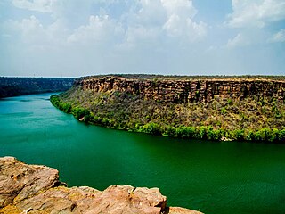
The Chambal River is a tributary of the Yamuna River in Central and Northern India, and thus forms part of the drainage system of the Ganges. The river flows north-northeast through Madhya Pradesh, running for a time through Rajasthan, then forming the boundary between Rajasthan and Madhya Pradesh before turning southeast to join the Yamuna in Uttar Pradesh state.

<span class="mw-page-title-main">Ganges Basin</span> Part of the Ganges-Brahmaputra basin

The Ganges Basin is a major part of the Ganges-Brahmaputra-Meghna (GBM) basin draining 1,999,000 square kilometres in Tibet, Nepal, India and Bangladesh. To the north, the Himalaya or lower parallel ranges beyond form the Ganges-Brahmaputra divide. On the west the Ganges Basin borders the Indus basin and then the Aravalli ridge. Southern limits are the Vindhyas and Chota Nagpur Plateau. On the east the Ganges merges with the Brahmaputra through a complex system of common distributaries into the Bay of Bengal. Its catchment lies in the states of Uttar Pradesh (294,364 km2), Madhya Pradesh (198,962 km2), Bihar (143,961 km2), Rajasthan (112,490 km2), West Bengal (71,485 km2), Haryana (34,341 km2), Himachal Pradesh (4,317 km2), Delhi, Arunachal Pradesh (1,484 km2), the whole of Bangladesh, Nepal and Bhutan. Several tributaries rise inside Tibet before flowing south through Nepal. The basin has a population of more than 500 million, making it the most populated river basin in the world.

<span class="mw-page-title-main">Gandaki River</span> River in Nepal and India

The Gandaki River, also known as the Narayani and Gandak, is one of the major rivers in Nepal and a left-bank tributary of the Ganges in India. Its total catchment area is 46,300 km2 (17,900 sq mi), most of it in Nepal. In the Nepal Himalayas, the Gandaki is notable for its deep canyon. The basin also contains three mountains over 8,000 m (26,000 ft), namely Dhaulagiri, Manaslu and Annapurna Massif. Dhaulagiri is the highest point of the Gandaki basin.

<span class="mw-page-title-main">Burhi Gandak River</span> River in India

The Burhi Gandak River is a tributary of the Ganges. It is also known as the Sikrahna river. The Burhi (“Old”) Gandak flows parallel to and east of the Gandak River in an old channel.

<span class="mw-page-title-main">Kosi River</span> River in Tibet, Nepal, and India

The Kosi or Koshi is a transboundary river which flows through China, Nepal and India. It drains the northern slopes of the Himalayas in Tibet and the southern slopes in Nepal. From a major confluence of tributaries north of the Chatra Gorge onwards, the Kosi River is also known as the Saptakoshi for its seven upper tributaries. These include the Tamur River originating from the Kanchenjunga area in the east and Arun River and the Sun Kosi from Tibet. The Sun Koshi's tributaries from east to west are the Dudh Koshi, Likhu Khola, Tamakoshi River, Bhote Koshi and Indravati. The Saptakoshi crosses into northern Bihar, India where it branches into distributaries before joining the Ganges near Kursela in Katihar district. The Kosi is the third-largest tributary of the Ganges by water discharge after the Ghaghara and the Yamuna.

<span class="mw-page-title-main">Seti River</span> River in Nepal

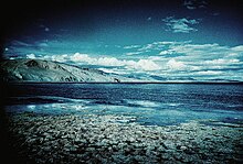
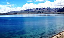
The Seti River is an important tributary of the Karnali river system that drains western Nepal.

<span class="mw-page-title-main">Pollution of the Ganges</span> Ongoing environmental disaster in India

The ongoing pollution of the Ganges, the largest river in the Indian subcontinent, poses a significant threat to human health and the environment. The river provides water to about 40% of India's population across 11 states. It serves an estimated population of 500 million people, more than any other river in the world.

<span class="mw-page-title-main">Geography of Bihar</span>

Bihar is located in the eastern region of India, between latitudes 24°20'10"N and 27°31'15"N and longitudes 83°19'50"E and 88°17'40"E. It is an entirely land–locked state, in a subtropical region of the temperate zone. Bihar lies between the humid West Bengal in the east and the sub humid Uttar Pradesh in the west, which provides it with a transitional position in respect of climate, economy and culture. It is bounded by Nepal in the north and by Jharkhand in the south. Bihar plain is divided into two unequal halves by the river Ganges which flows through the middle from west to east. Bihar's land has average elevation above sea level of 173 feet.

<span class="mw-page-title-main">Floods in Bihar</span>

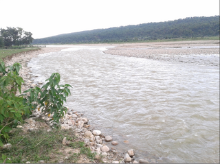
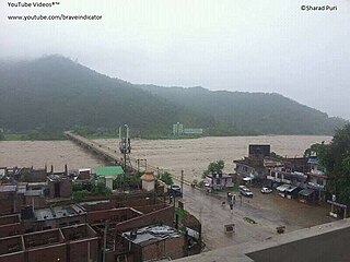
Bihar is India's most flood-prone state, with 76% of the population of North Bihar living under the recurring threat of devastating flooding. Bihar makes up 16.5% of India's flood-affected area and contains 22.1% of India's flood-affected population. About 73.06% of Bihar's geographical area, 68,800 square kilometres (26,600 sq mi) out of 94,160 square kilometres (36,360 sq mi), is affected. Each year, floods kill many and damage livestock and other assets worth millions. In total, floods have claimed 9,500 lives since the government started publishing figures in 1979. North Bihar districts are vulnerable to at least five major flood-causing rivers during monsoon – the Mahananda, Koshi, Bagmati, Burhi Gandak, and Gandak rivers – which originate in Nepal. Some South Bihar districts have also become vulnerable to floods, from the Son, Punpun, and Phalgu rivers. The 2013 flood affected over 5.9 million people in 3,768 villages in 20 districts in the state. The 2017 flood affected 19 districts in North Bihar, killing 514 people and affecting over 17 million.

<span class="mw-page-title-main">Sharda River</span> River along the India–Nepal border

The Sharda River, also called Kali River and Mahakali River, originates at [Limpiyadhura] in the Himalayas at an elevation of 3,600 m (11,800 ft) in the Darchula district in Sudurpaschim, Nepal. It flows along Nepal's western border with India and has a basin area of 14,871 km2 (5,742 sq mi). It joins the Ghaghra River, a tributary of the Ganges. It takes the name Kali River from the union of the two streams at Gunji as it flows through the hills. After Brahmadev Mandi near Tanakpur, it enters the Terai plains, where it is called the Sharda River.

<span class="mw-page-title-main">Punpun River</span> River in Bihar, India

The Punpun River is a tributary of the Ganges. It originates in Palamu district of Jharkhand and flows through Chatra, Aurangabad, Gaya and Patna districts of the Indian states of Jharkhand and Bihar. Punpun is a place named after the Punpun river in Patna which is situated on the bank of Punpun river. On the bank of Punpun people celebrate Chhath Puja.

<span class="mw-page-title-main">Kamala River</span> River in Nepal and Bihar

The Kamala River originates in Nepal and flows through the Indian state of Bihar.

<span class="mw-page-title-main">West Rapti River</span> River in Nepal

The West Rapti, also known as the Kuwano, is a river which drains Rapti Zone in Mid-Western Region, Nepal, then Awadh and Bhojpur-Purvanchal regions of Uttar Pradesh state, and finally India before joining the Ghaghara. It is a major left bank tributary of the Ganges, and is also known as the Karnali in Nepal.

<span class="mw-page-title-main">Babai River</span> River in South Asia

The Babai River originates in and completely drains Inner Terai Dang Valley of Mid-Western Nepal. Dang is an oval valley between the Mahabharat Range and Siwalik Hills in its eponymous district. Dang was anciently home to indigenous Tharu people and came to be ruled from India by the House of Tulsipur who also counted as one of the Baise Rajya —a confederation of 22 petty kingdoms in the Karnali (Ghagra) region. About 1760 AD all these kingdoms were annexed by the Shah Dynasty during the unification of Nepal, except Tulsipur lands south of the Siwalik Hills were not taken. Since Dang Valley was somewhat higher, cooler, better-drained and therefore less malarial than most of the country's Inner Terai, it was settled to some extent by Shah and Rana courtiers and other Paharis long before DDT was introduced to control the disease-bearing Anopheles mosquito.

<span class="mw-page-title-main">Lower Sharda Barrage</span> Dam in Uttar Pradesh, India

The Lower Sharda Barrage, is a dam nearly 28 km from Lakhimpur city in Uttar Pradesh, India.

References

  1. 1 2 Pathak, S. (2016). "Himalaya: Highest, Holy and Hijacked". In Raghubir Chand; Walter Leimgruber (eds.). Globalization and Marginalization in Mountain Regions. Perspectives on Geographical Marginality. Vol. 1. pp. 89–110. doi:10.1007/978-3-319-32649-8_7. ISBN   978-3-319-32648-1.
  2. Jain, S.K.; Agarwal, P.K.; Singh, V.P. (2007). Hydrology and Water Resources of India. The Netherlands: Springer. ISBN   978-1-4020-5179-1.
  3. "Karnali River: Longest River of Nepal « Wildlife in West Nepal". Archived from the original on 20 January 2008.
  4. Gautam, P., Fujiwara, Y. (2000) Magnetic polarity stratigraphy of Siwalik Group sediments of Karnali River section in western Nepal. Geophysical Journal International, Volume 142, Issue 3: 812-824. download pdf
  5. West Seti Hydroelectric Project (2007) Karnali Basin Cumulative Impact Assessment. Report by West Seti Hydro Limited, Kathmandu, Nepal download pdf Archived 2011-07-24 at the Wayback Machine
  6. Bhardwaj, V., Singh, D.S., Singh, A.K. (2010) Hydrogeochemistry of Ground water and anthopogenic control over dolomatization reaction in alluvial sediments of the Deoria district: Ganga Plain India. Environmental Earth Sciences 59:1099-1109. Abstract
  7. Bhardwaj, V., Singh, D.S., Singh, A.K. (2010) Water Quality of the Chhoti Gandak River using Principal Component Analysis, Ganga Plain, India. Journal of Earth System Sciences, 119 (1) pp 1-12. download pdf
  8. Bhardwaj, V., Singh, D.S., Singh, A.K. (2009) Environmental repercussions of cane-sugar industries on the Chhoti Gandak river basin, Ganga Plain, India. Environmental Monitoring and Assessment. (DOI 10.1007/s10661-009-1281-2). Abstract
  9. Singh, D.S., Awasthi, A., Bhardwaj, V. (2009) Control of Tectonics and Climate on Chhoti Gandak River Basin, East Ganga Plain, India. Himalayan Geology, Vol 30 (2) 2009, pp 147-154.
  10. Negi, Sharad Singh (1991). Himalayan rivers, lakes and glaciers. Indus. ISBN   9788185182612 . Retrieved 29 May 2010.{{cite book}}: |work= ignored (help)
  11. "The Karnali Zone of Nepal". www.ancientworlds.net. Archived from the original on 1 December 2008.
  12. Free-flowing rivers
  13. Smith, B.D.; Braulik, G.T.; Sinha, R. (2012). "Platanista gangetica ssp. gangetica". IUCN Red List of Threatened Species . 2012: e.T41756A17627639. doi: 10.2305/IUCN.UK.2012.RLTS.T41756A17627639.en . Retrieved 13 November 2021.
  14. I
  15. Parajuli, U. (2003) Water sharing Conflicts between Countries, and Approaches to resolving them. WASSA Project Reports, Volume 3 download pdf Archived 21 August 2007 at the Wayback Machine
  16. "Sea and Inland Navigation". www.indianscience.org.
  17. Wafed - Nepal [ permanent dead link ]