Sam Cooper Boulevard

Last updated

Sam Cooper Boulevard
Sam Cooper Blvd E 4.jpg
Maintained byCity of Memphis and TDOT
Length5.8 mi (9.3 km) [1]
West endUS 64.svgUS 70.svgUS 79.svg US 64  / US 70  / US 79 (East Parkway N)
East endI-40.svgI-240.svg I-40  / I-240 interchange

Sam Cooper Boulevard is an urban highway in Memphis, Tennessee, United States. The more recent western segment of the road follows a parkway design, while the older eastern portion, which was proposed and constructed as a segment of Interstate 40 (I-40), is built as a freeway, without at-grade intersections and traffic lights. The western terminus of Sam Cooper Boulevard is at East Parkway North. At the western termination point of the road there is a short concurrency of East Parkway North with U.S. Route 64 (US 64), US 70, and US 79. [2] From its western end, Sam Cooper Boulevard continues east for 5.8 miles (9.3 km) to reach its eastern terminus at the I-40/I-240 interchange. [1]

Contents

The road was originally planned in the 1950s. It was proposed as a segment of I-40 that would intersect the center of Memphis and continue west to Arkansas. The proposed route would have cut through Overton Park, an old forest public park in Memphis. Following a United States Supreme Court decision in 1971 the route was revised, I-40 was routed around Memphis in the north and plans of routing an Interstate highway through the city were abandoned. Ownership of the completed segments of the highway was transferred to the City of Memphis. [3] As a road that is owned and maintained by the City of Memphis, no route number is assigned to Sam Cooper Boulevard. [4]

History

Proposed route

I-40/I-240 planned routes (1955) Memphis, Tennessee 1955 Yellow Book.jpg
I-40/I-240 planned routes (1955)

In the 1950s, I-240 was planned as a complete loop around Memphis, consisting of a southern leg and a northern leg. I-40 was proposed to be routed through the center of the City of Memphis and to continue west into Arkansas over the Hernando de Soto Bridge, which was opened in 1973 and carries the traffic on modern I-40 over the Mississippi River. The I-240 loop was planned to route traffic not destined for Memphis around the city and to improve the flow of increasing traffic. The proposed I-240 loop would connect westbound and eastbound traffic to I-40 and southbound and northbound traffic to I-55. [5] [6]

What is now known as Sam Cooper Boulevard was planned as a segment of I-40, intersecting Memphis and distributing eastbound and westbound traffic with a destination in Memphis within the city. [5] [6] After a U.S. Supreme Court ruling stopped the plans to complete the section of I-40 cutting through Memphis in 1971, I-40 was re-routed. [3] The routing of modern I-40 coincides with the proposed routing of the northern leg of I-240. [5] [6] [7] Instead of the proposed I-240 loop around Memphis, the modern routing designates I-240 as the southern leg of the loop and I-40 as the northern leg of the loop. [7]

From the west to the east, the proposed routing of Sam Cooper Boulevard coincides with the route of modern I-40 from the Hernando de Soto Bridge in downtown Memphis to the modern I-40/I-240 interchange west of North Bellevue Boulevard in midtown Memphis. East of the I-40/I-240 interchange, the proposed route of Sam Cooper Boulevard would have been routed almost due east for circa 1.2 miles (1.9 km), parallel to and south of Overton Park Avenue and north of Peach Avenue until it reached Evergreen Street. From there, it would have continued northeast for about 0.5 miles (800 m) to reach the intersection of Galloway Avenue and North McLean Boulevard. From there, the route would have continued roughly to the east, parallel to and about .2 miles (320 m) south of North Parkway, just south of the Memphis Zoo and cutting through the northern portion of Overton Park, to connect to the western terminus of modern Sam Cooper Boulevard at East Parkway North. [5] [6] At the western terminus of Sam Cooper Boulevard there is a concurrency of East Parkway North with US 70, US 79 for 1.2 miles (2 km) south of Summer Avenue and north of Union Avenue. East Parkway North also overlaps State Route 277. [2]

Namesake

In 1968, the road was named after Sam Cooper, a Memphis businessman and longtime president of the Humko Corporation, a refinery of vegetable oils. He also was the vice president of the Federal Reserve Bank of Memphis. Cooper used his wealth to support St. Jude Children's Research Hospital and the University of Tennessee Medical School. [8] [9]

Citizen protests

Sam Cooper Blvd USGS 1986 Topo map panorama 2.png
Proposed route of Sam Cooper Boulevard through Memphis
(scroll for more)

In 1971, the United States Supreme Court in the case of Citizens to Preserve Overton Park v. Volpe stopped an extension of I-40 through Overton Park. [3] Sam Cooper Boulevard was originally planned as an extension of I-40 to intersect the City of Memphis. [5] [6] The proposed route was completed as proposed east of North Highland Street and west of I-240 in Berclair, in the northeastern quadrant of Memphis. The portion of Sam Cooper Boulevard west of North Highland Street was never built as planned. [10]

The unbuilt portion west of East Parkway North was not completed because it was proposed to go through Overton Park, the Memphis Zoo, and several historic neighborhoods of Memphis. Citizens residing in the neighborhoods of midtown Memphis along the route of the proposed highway were able to stop the route cutting through the old forest of Overton Park in the lawsuit. [3]

Once the case was decided by the United States Supreme Court, the ownership of the completed segments of Sam Cooper Boulevard was given to the City of Memphis. [3] Instead of following the planned route cutting through the center of Memphis, I-40 was routed around Memphis in the north. The new routing of I-40 to the north of Memphis follows the proposed northern leg of the I-240 loop. [5] [6] [7]

Construction of the route segment of Sam Cooper Boulevard west of North Highland Street and east of East Parkway North began in 2001 and was completed in 2003. The construction did not follow the originally proposed freeway design for the road but implemented a parkway design with at-grade intersections, a raised median, traffic lights and sidewalks for pedestrians.

21st century

Extension to East Parkway

Tillman St intersection (2009) Sam Cooper Blvd Tillman W.jpg
Tillman St intersection (2009)

In 2001, the City of Memphis began construction on an extension of Sam Cooper Boulevard west of the North Highland Street exit. After completion of the first phase of construction, Sam Cooper Boulevard transitioned into Broad Avenue between North Holmes Street and Vandalia Street, about .4 miles (640 m) west of North Highland Street. [7] The route coinciding with Broad Avenue had several intersections with traffic signals and two major railroad crossings, creating traffic congestion at peak times. The extension of Sam Cooper Boulevard was routed about 300 to 400 feet (91–122 m) south of Broad Avenue. Several of the intersections were eliminated, a viaduct was constructed to avoid the railroad crossings and the route was extended to East Parkway North.

The original route east of North Highland Street, was designed as a six-lane freeway without intersections, traffic signals and without sidewalks for pedestrians, allowing only motorized traffic on the road. The extension of Sam Cooper Boulevard west of the North Highland Street exit was constructed as a six-lane controlled-access parkway. Pedestrians are allowed on the route on sidewalks installed on both sides of the parkway west of Vandalia Street, located about 1,400 feet (430 m) west of North Highland Street. The median is raised and there are at-grade intersections present equipped with traffic signals and pedestrian crossings. [1] The segment of Sam Cooper Boulevard west of North Highland Street and east of East Parkway North was completed in 2003.

Random shootings at cars

In 2004, it was reported by local newsmedia that several cars driving on Sam Cooper Boulevard had been shot at randomly in the section west of Tillman Street and east of North Hollywood Street in the Binghampton neighborhood. The Memphis Police Department (MPD) reported 13 shootings between August and October of that year. A spokesman for the MPD stated that only vehicle damage had occurred and that no persons were hurt in the shootings. [11] Police recovered a 9 mm bullet from the front door of one vehicle. [12] A special police task force was assigned to the case. [11] It is not known if the shooter was caught.

Revitalization attempts

Broad Avenue (2010) Broad Ave Binghampton Memphis TN 3.jpg
Broad Avenue (2010)

In 2006, citizens from the Binghampton neighborhood of Memphis voiced concerns about negative effects that the completion of the western portion of Sam Cooper Boulevard has had on the community. Claims were made that construction of the road between North Highland Street and East Parkway North cut the Binghampton area in half by creating "high-speed traffic" and "confusing traffic patterns".[ citation needed ] It was mentioned that the routing of Sam Cooper Boulevard to the south of Broad Avenue had "effectively made" the circa 1.4-mile-long (2.3 km) stretch of Broad Avenue a "ghost town", creating vacant lots in the partly industrial area and an unsafe neighborhood. [13]

The Memphis Flyer cites Robert Montague, executive director of the Binghampton Development Corporation: "When they built Sam Cooper, this area really got buried".[ citation needed ] Citizens suggested changes in the zoning and a re-design of the Broad Avenue area north of Sam Cooper Boulevard and south of Summer Avenue to re-vitalize that part of the neighborhood and attract business and residents. [13] The following year, trees and shrubs were planted alongside Sam Cooper Boulevard and in the median west of North Highland Street. A few decorative flowerbeds were also installed in the median of the road to enhance the parkway design of the road.

Major intersections

Proposed exits

Exit 8 at Graham St (2009) Sam Cooper Blvd Ped E Exit Graham.jpg
Exit 8 at Graham St (2009)

Sam Cooper Boulevard is owned and maintained by the City of Memphis. [3] No route number is assigned to Sam Cooper Boulevard and it is not a designated business route for Interstate traffic headed for Memphis. [4] The exit numbering system on Sam Cooper Boulevard has not been changed since the route was planned. The exits are still numbered as if I-40 ran along Sam Cooper Boulevard as it was proposed straight through Memphis to connect to Arkansas over the Hernando de Soto Bridge. In fact, overhead gantry signs still told westbound motorists that they were heading towards Little Rock until the lettering was removed from the signs in March 2016.[ citation needed ]

The exits for I-40 along the proposed route segment through the center of Memphis, west of East Parkway North, that was never completed were planned in downtown Memphis (planned as exit 1), at Danny Thomas Boulevard (planned as exit 2), west of North Bellevue Boulevard as an interchange with modern-day I-240 (planned as exit 3) and at Stonewall Street in the Evergreen District of midtown Memphis (planned as exit 4). I-40 exits were proposed at East Parkway North (planned as exit 5) and Tillman Street (planned as exit 6). [6]

The planned exit 1 along Sam Cooper Boulevard exists as exit 1 and exit 1A of modern-day I-40 in downtown Memphis just south of the Pyramid Arena. Exit 1 serves traffic to and from North Riverside Drive and Front Street; at exit 1A westbound traffic exits to North 2nd Street and eastbound traffic enters I-40 from North 3rd Street. Planned exit 2 coincides with modern exits 1B–D on I-40 at Danny Thomas Boulevard. Planned exit 3 exists as exit 1E on modern I-40 at the I-40/I-240 interchange west of North Bellevue Boulevard in the Medical district of Memphis. Planned exit 4 at Stonewall Street was never constructed. Planned exit 5 is an at-grade intersection with traffic signals at the western terminus of Sam Cooper Boulevard at East Parkway North, and planned exit 6 is an at-grade intersection with traffic lights at Tillman Street. Exits 7–9 and Exits 10A and 10B were constructed as proposed. [7]

Existing exits

Western terminus (2010) Overton Park Billboard Sam Cooper at E Parkway Memphis TN 5.jpg
Western terminus (2010)

The following table lists the existing exits and intersections of Sam Cooper Boulevard as of 2017 from west to east. [1] The entire route is in Memphis, Shelby County.

mikmExitDestinationsNotes
0.00.0US 64.svgUS 70.svgUS 79.svgTennessee 277.svg US 64  / US 70  / US 79 (East Parkway North) / SR 277 Western terminus
1.21.9Tillman Street
Western end of freeway section
2.13.47Highland Street
3.15.08Graham Street
4.26.89Perkins Road
5.58.910West plate blue.svg
I-40.svg
West plate blue.svg
I-240.svg
I-40 west / I-240 west Little Rock, Jackson, Mississippi
Eastbound exit and westbound entrance; signed as exits 10A (I-240) and 10B (I-40); I-40 exit 12C
5.89.3East plate blue.svg
I-40.svg
I-40 east Nashville
Eastern terminus
1.000 mi = 1.609 km; 1.000 km = 0.621 mi

Points of interest

Sam Cooper Blvd Broad Ave USGS 1986 DOQ.png
Sam Cooper Blvd. transition into Broad Ave. (Source: USGS, 1986)

Points of interest along Sam Cooper Boulevard (west to east).

Related Research Articles

<span class="mw-page-title-main">Interstate 40</span> Interstate Highway across south-central US

Interstate 40 (I-40) is a major east–west transcontinental Interstate Highway in the southeastern and southwestern portions of the United States. At a length of 2,556.61 miles (4,114.46 km), it is the third-longest Interstate Highway in the country, after I-90 and I-80. From west to east, it passes through California, Arizona, New Mexico, Texas, Oklahoma, Arkansas, Tennessee, and North Carolina. Its western terminus is at I-15 in Barstow, California, while its eastern terminus is at a concurrency with U.S. Route 117 (US 117) and North Carolina Highway 132 (NC 132) in Wilmington, North Carolina. Major cities served by the interstate include Flagstaff, Arizona; Albuquerque, New Mexico; Amarillo, Texas; Oklahoma City, Oklahoma; Little Rock, Arkansas; Memphis, Nashville, and Knoxville in Tennessee; and Asheville, Winston-Salem, Greensboro, Durham, Raleigh, and Wilmington in North Carolina.

<span class="mw-page-title-main">U.S. Route 79</span> Highway in the United States

U.S. Route 79 is a United States highway in the Southern United States. The route is officially considered and labeled as a north–south highway, but its path is actually more of a diagonal northeast–southwest highway. The highway's northern/eastern terminus is in Russellville, Kentucky, at an intersection with U.S. Route 68 and KY 80. Its southern/western terminus is in Round Rock, Texas, at an interchange with Interstate 35, ten miles (16 km) north of Austin. US 79, US 68, and Interstate 24/US 62 are the primary east–west access points for the Land Between the Lakes recreation area straddling the Kentucky/Tennessee border.

<span class="mw-page-title-main">Interstate 220 (Mississippi)</span> Highway in Mississippi

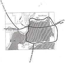
Interstate 220 (I-220) in Mississippi is a loop around Jackson that provides an Interstate connection for I-55 and I-20. The northern terminus for the route is in the suburb of Ridgeland, at I-55 exit 104. The highway was Mississippi's first auxiliary Interstate, complete by 1981.

<span class="mw-page-title-main">U.S. Route 92</span> Highway in the United States

U.S. Route 92 or U.S. Highway 92 is a 181-mile (291 km.) U.S. Route entirely in the U.S. state of Florida. The western terminus is at US 19 Alt. and SR 687 in downtown St. Petersburg. The eastern terminus is at SR A1A in Daytona Beach.

<span class="mw-page-title-main">Interstate 395 (Maryland)</span> Short Interstate Highway in Baltimore, Maryland

Interstate 395 (I-395) is an auxiliary Interstate Highway in the US state of Maryland. Known as Cal Ripken Way, the highway runs 1.98 miles (3.19 km) from I-95 north to Howard Street and Camden Street in Downtown Baltimore, where it provides access to the Inner Harbor and the Baltimore Convention Center. The Interstate also serves the Camden Yards Sports Complex, which contains M&T Bank Stadium and Oriole Park at Camden Yards, homes of the Baltimore Ravens and Baltimore Orioles, respectively. I-395 also serves as the southern terminus of Martin Luther King Jr. Boulevard, an urban arterial that provides a western bypass of Downtown Baltimore and connects I-95 with U.S. Route 40 (US 40), US 1, and I-83. The Interstate is maintained by the Maryland Transportation Authority (MDTA) and, like all Interstates, is a part of the National Highway System.

<span class="mw-page-title-main">Tennessee State Route 1</span> State highway in Tennessee, United States

State Route 1, known as the Memphis to Bristol Highway, is a 538.8-mile-long (867.1 km) mostly-unsigned state highway in the U.S. state of Tennessee. It stretches from the Arkansas state line at Memphis in the southwest corner of the state to Bristol in the northeast part. Most of the route travels concurrently with U.S. Route 70 and US 11W. It is the longest highway of any kind in the state of Tennessee. The route is signed as both in the state of Tennessee, a Primary and Secondary Highway

<span class="mw-page-title-main">Interstate 240 (Tennessee)</span> Highway in Tennessee

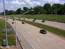
Interstate 240 (I-240) is a 19.27-mile-long (31.01 km) auxiliary Interstate Highway in the US state of Tennessee that forms a bypass around the southern and eastern neighborhoods of Memphis. Combined, I-240 and its parent, I-40, form a contiguous beltway around most of Memphis. I-240 runs from I-40 in Midtown Memphis to I-40 and Sam Cooper Boulevard in East Memphis. Throughout its length, it provides access to I-55, multiple U.S. and state routes, and the Memphis International Airport. The segment between the western terminus and I-55 is a north–south route, and the segment between I-55 and the eastern terminus runs east to west. Throughout its length, I-240 is designated as the Dr. Martin Luther King Jr. Expressway, the W.B. Fowler Sr. Expressway, and the Avron B. Fogelman Expressway.

<span class="mw-page-title-main">Jackie Robinson Parkway</span> Highway in New York

The Jackie Robinson Parkway is a 4.95-mile (7.97 km) controlled-access parkway in the New York City boroughs of Brooklyn and Queens. The western terminus of the parkway is at Jamaica Avenue in the Brooklyn neighborhood of East New York. It runs through Highland Park, along the north side of Ridgewood Reservoir, and through Forest Park. The eastern terminus is at the Kew Gardens Interchange in Kew Gardens, Queens, where the Jackie Robinson Parkway meets the Grand Central Parkway and Interstate 678. It is designated New York State Route 908B (NY 908B), an unsigned reference route. The parkway was officially named the Interboro Parkway until 1997, when it was renamed for trailblazing Major League Baseball player Jackie Robinson.

<span class="mw-page-title-main">Interstate 55 in Tennessee</span> Interstate Highway in Tennessee, United States

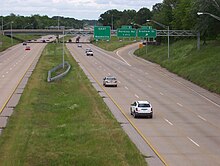
Interstate 55 (I-55) is part of the Interstate Highway System that runs from LaPlace, Louisiana, to Chicago, Illinois. In the state of Tennessee, the Interstate is located entirely within the state's second-largest city of Memphis, running 12.28 miles (19.76 km) from the Mississippi state line in the Whitehaven neighborhood to the Arkansas border across the Mississippi River. Of the six states that the Interstate passes through, the segment in Tennessee is the shortest, as well as the shortest mainline Interstate segment in Tennessee. I-55 serves a number of neighborhoods and industrial areas in the southwestern portion of Memphis, and also provides access to the Memphis International Airport, the second-busiest cargo airport in the world.

<span class="mw-page-title-main">Tennessee State Route 23</span> State highway in Tennessee, United States

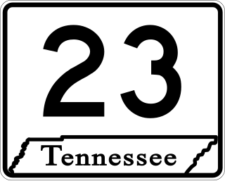
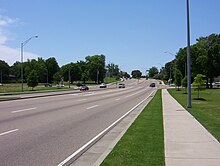
State Route 23 is an east–west major arterial urban highway running from Bellevue Boulevard near downtown Memphis to Interstate 240 near Shelby Farms in Shelby County, Tennessee.

<span class="mw-page-title-main">Interstate 40 in Tennessee</span> Interstate Highway in Tennessee, United States

Interstate 40 (I-40) is part of the Interstate Highway System that runs 2,556.61 miles (4,114.46 km) from Barstow, California, to Wilmington, North Carolina. The highway crosses Tennessee from west to east, from the Mississippi River at the Arkansas border to the Blue Ridge Mountains at the North Carolina border. At 455.28 miles (732.70 km), the Tennessee segment of I-40 is the longest of the eight states through which it passes and the state's longest Interstate Highway.

<span class="mw-page-title-main">Evergreen, Memphis</span> United States historic place

Evergreen Historic District is one of the oldest neighborhoods in Memphis, Tennessee.

<span class="mw-page-title-main">Tennessee State Route 57</span> State highway in Tennessee, United States

State Route 57 is an east–west highway that runs from Memphis to the Mississippi state line near Pickwick Dam and Pickwick Landing State Park. Except for in Shelby County and western Fayette County, SR 57 is a two lane road generally with a 55 mph (89 km/h) speed limit. The majority of the road follows the path of the Memphis and Charleston Railroad.

<span class="mw-page-title-main">Binghampton, Memphis</span> Human settlement in Memphis, Tennessee, U.S.

Binghampton is a neighborhood on an edge of Midtown in Memphis, Tennessee. It is named after W. H. Bingham, an Irish immigrant, hotelier, planter, magistrate, politician, and entrepreneur who founded a town to the east and slightly north of the Memphis city limits in 1893.

<span class="mw-page-title-main">Memphis Parkway System</span> United States historic place

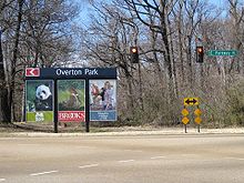
The Memphis Parkway System is a system of parkways that formed the original outer beltway around Memphis, Tennessee. They consist of South Parkway, East Parkway, and North Parkway. Designed by George Kessler, the Parkway System connects Martin Luther King Jr. Riverside Park with Overton Park. The system was put on the National Register of Historic Places on July 3, 1989.

<span class="mw-page-title-main">Tennessee State Route 277</span> State highway in Tennessee, United States

State Route 277, also known as Airways Boulevard and East Parkway, is a major north–south urban state highway in Memphis, Shelby County, Tennessee.

<span class="mw-page-title-main">Tennessee State Route 186</span> Highway in Tennessee

State Route 186 is a state highway in the U.S. state of Tennessee. It runs from Trenton southward to Jackson, passing through the towns of Gibson and Three Way along the way. The southern portion serves as a western bypass for the city of Jackson, which is signed as U.S. Route 45 Bypass.

Highway revolts have occurred in cities and regions across the United States. In many cities, there remain unused highways, abruptly terminating freeway alignments, and short stretches of freeway in the middle of nowhere, all of which are evidence of larger projects which were never completed. In some instances, freeway revolts have led to the eventual removal or relocation of freeways that had been built.

<span class="mw-page-title-main">Memphis tanker truck disaster</span> 1988 explosion and fire in Memphis, Tennessee, United States

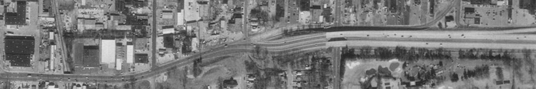
On December 23, 1988, a tractor-trailer tanker truck hauling liquefied propane crashed on an exit ramp at the Interstate 40/Interstate 240 (I-40/I-240) interchange in downtown Memphis, Tennessee, US. The crash ruptured the tank; the leaking gas exploded, setting multiple vehicles and structures on fire. The explosion propelled the tank 125 yards (114 m) into a residential complex and started additional fires. The accident caused nine deaths and ten injuries. The interchange where the accident occurred was considered unsafe and poorly designed, and had been the site of several previous accidents; it was completely rebuilt in the 2000s.

References

  1. 1 2 3 4 Google (May 15, 2009). "Sam Cooper Boulevard from East Parkway to Interstate-40/Interstate-240 Interchange" (Map). Google Maps . Google. Retrieved May 15, 2009.
  2. 1 2 Google (May 18, 2009). "East Parkway Memphis, Tennessee" (Map). Google Maps. Google. Retrieved May 18, 2009.
  3. 1 2 3 4 5 6 Citizens to Preserve Overton Park v. Volpe , 401U.S.402 (March 2, 1971).
  4. 1 2 "Interstate Business Routes - Business Route 40". Interstate-Guide.com. October 8, 2008. Retrieved May 17, 2009.[ self-published source ]
  5. 1 2 3 4 5 6 The H. M. Gousha Company (1963). Shell Street Guide and Metropolitan Map of Memphis (Map). Chicago: The H. M. Gousha Company.
  6. 1 2 3 4 5 6 7 First National Bank of Memphis (1971). Memphis and Vicinity Map (Map). Memphis, Tennessee: Graphic Publications.
  7. 1 2 3 4 5 Rand McNally (2003). Memphis, Tennessee City Map (Map). Skokie, Illinois: Rand McNally. ISBN   0-528-97484-X.
  8. "ISJL: Digital Archive - Memphis". The Goldring/Woldenberg Institute of Southern Jewish Life. 2006. Retrieved May 15, 2009.
  9. Lewis, Selma S. (1998). A Biblical People in the Bible Belt: The Jewish Community of Memphis, Tennessee. Macon, Georgia: Mercer University Press. p. 130. ISBN   0-86554-602-9.
  10. "Interstate 240 Tennessee". Interstate-Guide.com. Retrieved May 15, 2009.[ self-published source ]
  11. 1 2 "And then there were 13". Action News 5. WMC-TV. October 15, 2004. Archived from the original on March 7, 2006. Retrieved May 18, 2009.
  12. "Four new reports about vehicles being shot at on Sam Cooper Boulevard". Action News 5. WMC-TV. October 13, 2004. Retrieved May 18, 2009.
  13. 1 2 Cashiola, Mary (February 10, 2006). "Bringing Back Binghamton". Memphis Flyer. Retrieved May 17, 2009.