Interstate 370 (I-370) is a 2.54-mile (4.09 km) Interstate Highway spur route off I-270 in Gaithersburg, Maryland, to the western end of the Maryland Route 200 toll road at an interchange that provides access to the park and ride lot at the Shady Grove station on the Red Line of the Washington Metro. Despite the number, I-370 does not connect to I-70 itself. The road continues to the west of I-270 as Sam Eig Highway, a surface road. Along the way, I-370 has interchanges with MD 355 and Shady Grove Road. The freeway was completed in the late 1980s to connect I-270 to the Shady Grove station. I-370 was always part of the planned Intercounty Connector but was the only segment to be built at the time. The opening of MD 200 east of I-370 resulted in the truncation of I-370 to the interchange with MD 200 and the redesignation of the road leading into the Shady Grove station as MD 200A.

State Highway 121 is a state highway angling from southwest to northeast through north central Texas. It runs from Cleburne, Texas at US 67 to SH 78 in Bonham, Texas, just north of a junction with US 82.

State Highway 360 is a 28-mile (45 km) north–south freeway in the Dallas–Fort Worth metroplex in the U.S. state of Texas. It runs north from an at-grade intersection with US 287 in Mansfield, near the Ellis-Johnson county line to a partial interchange with SH 121 in Grapevine, near Dallas/Fort Worth International Airport. The highway serves as a local north–south route running through the center of the metroplex, linking together the southern and northern suburbs to the core. Between US 287 and Camp Wisdom Road/Sublett Road, SH 360 follows a pair of frontage roads along a four-lane tollway known as the 360 Tollway, a tollway operated by the NTTA. Between Camp Wisdom Road/Sublett Road and SH 121, SH 360 follows a toll-free freeway maintained by TxDOT.

State Highway 99, also known as the Grand Parkway, is a beltway in the U.S. state of Texas. Its first section opened on August 31, 1994. When the route is completed, it will be the longest beltway in the U.S., the world's seventh-longest ring road, and the third (outer) loop of the Houston–The Woodlands–Sugar Land metropolitan area, with Interstate 610 being the first (inner) loop and Beltway 8 being the second (middle) loop. The proposed 170-mile (270 km) loop has been divided into 11 separate segments for construction and funding purposes. In May 2019, the Texas Department of Transportation gave the Grand Parkway a secondary designation as the Mayor Bob Lanier Memorial Parkway, honoring Bob Lanier, who served as the mayor of Houston from 1992 to 1998 and who had spearheaded the creation of the Grand Parkway.

Beltway 8 (BW8), the Sam Houston Parkway, along with the Sam Houston Tollway, is an 88-mile (142 km) beltway around the city of Houston, Texas, United States, lying entirely within Harris County.
The President George Bush Turnpike (PGBT) is a 52-mile (84 km) controlled-access toll road running through the northern, northeastern and western suburbs, forming a partial loop around Dallas, Texas, United States. It is named for the late George H. W. Bush, the 41st president of the United States. At its west end near Belt Line Road in Irving, State Highway 161 continues southwest to Interstate 20 (I-20) in Grand Prairie. The discontinuous free frontage roads along the turnpike from I-35E in Carrollton east to its end at I-30 in Garland are assigned the State Highway 190 designation. SH 190 signage appears only along the Rowlett, Garland, Richardson, Plano, and Carrollton sections of the frontage road with the undersign "frontage road only". At intersections with city streets, only the Bush Turnpike signs are displayed, not the SH 190 signage. Prior to the construction of the main lanes as a tollway, SH 190 was used as the name of the planned main lanes too. Similarly, the part west of I-35E was planned as part of SH 161. Bush Turnpike is signed as a north–south road from I-20 to I-35E, an east–west road from I-35E to the Merritt Main Lane Gantry and as a north–south road from the Merritt Main Lane Gantry to I-30, as Bush Turnpike makes a nearly 90-degree curve in both places.

The Dallas North Tollway is a 30.2-mile (49 km) controlled-access toll road operated by the North Texas Tollway Authority (NTTA), which runs from Interstate 35E near downtown Dallas, Texas (USA), to U.S. Highway 380, in Frisco, Texas.

Interstate 635 (I-635) is a 36.999-mile-long (59.544 km) partial loop around Dallas, Texas, in the United States between I-20 in Balch Springs and State Highway 121 (SH 121) at the north entrance of the Dallas Fort Worth International Airport in Grapevine. It intersects I-35E at exits 27B and 27C but does not connect with I-35W. I-635 and a part of I-20 are collectively designated as the Lyndon B. Johnson Freeway; known locally as the LBJ Freeway, or simply LBJ. The roadway is named after Lyndon B. Johnson, the former U.S. senator from Texas and the 37th vice-president and 36th president of the U.S. Where I-635 ends at I-20, I-20 continues the LBJ Freeway designation heading west. Since the portion of I-20 between Spur 408 to I-635 retains the same names as I-635, the two highways are considered three-quarters of the beltway around Dallas. Together with Spur 408, a portion of Loop 12, and a portion of I-35E, I-635 and I-20 complete the beltway.

The Westpark Tollway, also Fort Bend Westpark Tollway, is a controlled-access toll road in Texas, serving western Houston and Harris County, and northeastern Fort Bend County. Construction on the facility began in 2001 and portions of the road were opened to traffic in May 2004. Construction of the roadway was completed in August 2005. The Westpark Tollway begins on Westpark Drive just past the South Rice Avenue intersection in the Uptown District of Houston and runs approximately 22 miles (35 km) west to Farm to Market Road 1093 just past Farm to Market Road 723 in Fulshear, Texas. It runs roughly parallel and to the south of Westheimer Road in Harris County and concurrently with FM 1093 in Fort Bend County.
A directional interchange, colloquially known as a stack interchange, is a type of grade-separated junction between two controlled-access highways that allows for free-flowing movement to and from all directions of traffic. These interchanges eliminate the problems of weaving, have the highest vehicle capacity, and vehicles travel shorter distances when compared to different types of interchanges.

The Fort Bend Parkway Toll Road is the Fort Bend County portion of a controlled-access toll road connecting Sienna in eastern Fort Bend County to US 90A in southwestern Harris County. It is administered by the Fort Bend County Toll Road Authority (FBCTRA). The Harris County Toll Road Authority (HCTRA) administers the Harris County segment of the road — from just south of Beltway 8 at the county line to US 90A — and uses its purple pentagonal shield labeled as Fort Bend Toll Road. It is proposed to reach a northern terminus at the southwestern corner of Interstate 610 in the future, and SH 99 at its southern terminus.

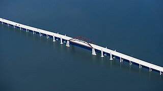
The Lewisville Lake Toll Bridge (LLTB) is a 1.7-mile (2.7 km) tied arch bridge crossing Lewisville Lake in Denton County, Texas, USA. Operated by North Texas Tollway Authority (NTTA), the four-lane toll bridge connects Swisher Road in Lake Dallas to Eldorado Parkway in Little Elm. It is one segment of the 13-mile (21 km) Lewisville Lake Corridor, which connects Interstate 35E and Dallas North Tollway.
The Chisholm Trail Parkway is a controlled-access toll road operated by the North Texas Tollway Authority (NTTA) in Tarrant and Johnson counties connecting the central business district of the city of Fort Worth at Interstate 30 to US 67 in Cleburne.

State Highway 470 is a freeway located in the southwestern portion of the Denver Metro Area. It is also the southwestern portion of the Denver Metro area's beltway. SH 470 begins at US 6 in Golden and heads south interchanging Interstate 70 and then US 285 outside Morrison. After leaving Morrison, it then heads east passing by Littleton and through Highlands Ranch before interchanging Interstate 25 in Lone Tree, where the freeway continues as a tollway and where the state highway designation ends.

Federico Peña Boulevard, named for former Denver Mayor Federico Peña, is an 11.1-mile-long (17.9 km) freeway located in Adams County and the City and County of Denver, Colorado. The freeway, which opened in 1993, provides the primary vehicular access into Denver International Airport which opened at the same time. Peña Boulevard begins as an extension of Airport Boulevard in Aurora at an interchange with Interstate 70 (I-70) and travels north, then east to end at the airport, with an intermediate interchange with the E-470 tollway.

U.S. Route 183 (US 183) is a north-south U.S. highway that begins in Texas in Refugio at an intersection with US 77 concurrent with US 77 Alt. The highway runs through many small communities with Austin being the only major city along its route. The highway exits Texas concurrent with US 70, crossing into Oklahoma.

U.S. Highway 75 (US 75) is a part of the U.S. Highway System that travels from Interstate 345 (I-345) in Dallas, Texas northward to the Canadian border at Noyes, Minnesota. In the state of Texas it runs from I-345 in Dallas and heads north to the Oklahoma state line.
There are approximately 25 current toll roads in the state of Texas. Toll roads are more common in Texas than in many other U.S. states, since the relatively low revenues from the state's gasoline tax limits highway planners' means to fund the construction and operation of highways.

Spur 399 is a short, limited-access spur highway located in Collin County, Texas, and connects State Highway 121 (SH 121) and the US Highway 75 to SH 5, in McKinney. The highway is just over a mile long, and was originally designated in 1964, but was redesignated in 1989.
The Collin County Outer Loop is a partially-built beltway in Collin County, Texas. The highway would travel from the Denton County line to the Rockwall County line, passing through cities in the northern and eastern parts of the county.


