Texas State Highway 121

Last updated

Texas 121.svg

State Highway 121

Texas State Highway 121
SH 121; mainline in red, business routes in blue
Route information
Maintained by TxDOT
Length85.563 mi [1]  (137.700 km)
Existedby 1939–present
Major junctions
Southwest endUS 67.svg US 67 in Cleburne
Major intersections
Northeast endTexas 78.svg SH 78 in Bonham
Location
Country United States
State Texas
Highway system
Texas 120.svg SH 120 Texas 122.svg SH 122

State Highway 121 (SH 121) is a state highway angling from southwest to northeast through north central Texas. It runs from Cleburne, Texas at US 67 to SH 78 in Bonham, Texas, just north of a junction with US 82.

Contents

Between Fort Worth and Euless, SH 121 is known as Airport Freeway (east of Euless, this name applies to SH 183). East of Coppell, the highway functions as the frontage road for the Sam Rayburn Tollway, a toll road that runs northeast to McKinney. From McKinney to Melissa, the state highway is concurrent with US 75 and the North Central Expressway. Northeast of Melissa, SH 121 is a less-traveled roadway often referred to as the Sam Rayburn Highway.

Route description

SH 121 Business west from I-35E towards Grapevine Bus Hwy 121 south from IH35E south.jpg
SH 121 Business west from I-35E towards Grapevine

Sections between downtown Fort Worth and Grapevine are freeway, including a small segment near Hurst that coincides with Interstate 820. At Bedford, Texas it has an interchange with SH 183, the Irving freeway that leads toward Dallas; it has an interchange with SH 360, which leads toward Arlington, just to the west of the north entrance to the Dallas/Fort Worth International Airport, to which State Highway 121 gives access. At Grapevine it has interchanges with SH 114 and Interstate 635 before becoming a limited-access tollway that passes between Lewisville and Frisco.

Signage originally used on the tolled mainlanes of SH 121 (now the Sam Rayburn Tollway) from 2006 to 2009. Toll Texas 121.svg
Signage originally used on the tolled mainlanes of SH 121 (now the Sam Rayburn Tollway) from 2006 to 2009.

It is very heavily traveled south and west of McKinney and has become an urban highway due to the rapid growth of the Dallas–Fort Worth metroplex. Service roads extending southwest to northeast along the corridor from Lewisville to McKinney are free of charge; however the main lanes within the right-of-way are tolled as part of the Sam Rayburn Tollway operated by the North Texas Tollway Authority (NTTA). The highway's northeastern section between Melissa and Bonham carries less traffic and until recently was a two-lane rural highway. However, in recent years with an increase in traffic, the 19 mile section between the Collin–Fannin county line and its junction with SH 56 in Bonham has been upgraded to a "Super Two" highway system. This allows for alternating passing lanes. Beginning in 2016, the segment between Melissa and the Collin–Fannin county line is being upgraded to a four-lane divided highway system. In addition, a two-mile stretch between SH 56 and US 82 within Bonham city limits, was upgraded to a four-lane highway system with a continuous left-hand turn lane. Long term planning calls for upgrading the 19 mile stretch, from the Collin–Fannin county line to SH 56 in Bonham, into a four-lane divided highway system.

It meets Interstate 35E at Lewisville, SH 289 near Frisco, US 75 and US 380 in McKinney, US 69 at Trenton, and SH 78 just north of Bonham.

Construction began in 2009 on the extension of 121 south from Fort Worth to Cleburne, as a toll road called Chisholm Trail Parkway in Tarrant and Johnson Counties. This section is operated by the NTTA and the entire project, from I-30 to U.S. 67 opened to traffic in 2013. [2]

In March 2009, work was completed on the eventual southbound lanes on a short stretch of 121 northeast of DFW Airport, which currently shares southbound and northbound traffic. This work upgraded two signalized at-grade intersections to a freeway, with overpasses at both intersections, improving traffic in that area. [3] The northbound freeway lanes are currently under construction, which also include new, separate exits and entrances for Freeport Parkway and Grapevine Mills Boulevard/Sandy Lake Road.

Interchange between SH 121 and SH 121 Business Route Business Texas State Highway 121.JPG
Interchange between SH 121 and SH 121 Business Route

Sam Rayburn Tollway

From McKinney to Coppell, State Highway 121 acts as a frontage road to Sam Rayburn Tollway, contrary to the popular misconception that the Sam Rayburn Tollway was the new SH 121.

Controversy

In early 2007, the Spanish firm Cintra agreed to a $2.8 billion, 50-year deal where they would lease the highway from TxDOT, finish building and maintain it, and collect the tolls. [4] However, critics of the deal questioned both its length—the contract allowed Cintra to collect tolls for 50 years—and the fact that the North Texas Tollway Authority (NTTA) was prevented from bidding on the contract. In addition, general opposition to the toll plan organized, pointing out that the segment through Denton County had already been paid for by taxpayer money. [5]

To answer some of these complaints, Texas legislators pressed the Texas Department of Transportation to allow the NTTA to bid. [6] The Authority announced their proposed bid in early May 2007, which would provide approximately $3.3 billion in road funding, but is based on traffic counts that differ from those used by Cintra. [7]

On June 28, 2007, the Texas Transportation Commission announced it would pursue the proposal from the North Texas Tollway Authority (NTTA). [8]

History

SH 121 was originally numbered on March 17, 1927, as a direct routing between Fort Worth and SH 40 near the Dallas–Denton county line. [9] On April 24, 1928, it was extended to McKinney. [10] By 1933, the route had been completed from Ft. Worth northeast through Grapevine to its intersection with SH 40/U.S. Route 77 in far southern Denton County. On July 15, 1935, the east end was truncated to the Denton–Dallas county line. [11] On January 6, 1939, the section from the Dallas–Denton county line to SH 40/US 77 was restored. [12] A road was designated on February 21, 1938, from SH 114 to SH 121; either SH 114 Loop or SH 121 Loop. This was renumbered as Loop 10 on September 26, 1939. [13]

On November 24, 1941, SH 121 was extended from old US 77 to new US 77. On December 16, 1943, the section of SH 121 from US 77 (former SH 40) to McKinney was restored, and the ambitious plan to extend SH 121 northeast beyond McKinney to Bonham was approved by TxDOT, a part of which absorbed Farm to Market Road 82 between Bonham and Trenton. The section from Bonham to Randolph was designated as SH 263 until March 21, 1939. It was not until 1954 that the next section of this highway was completed between U.S. 77 at Lewisville and U.S. Route 75 near McKinney. The final section between McKinney and Trenton was not completed until November 20, 1963, including an extension around the western side of Bonham. In 1965, the section from downtown Fort Worth to Interstate 820 was transferred to newly completed freeway sections. On November 31, 1969, SH 121 was rerouted over Spur 459, which was cancelled. The old route of SH 121 was given to the city of Grapevine.

TxDOT proposed extending SH 121 to FM 1187, via a route to be known as the Northside–Southwest Freeway, on October 4, 1973. [14] This proposed extension was canceled on August 29, 1985. [15]

On April 14, 1980, SH 121 was relocated in Bedford and Grapevine. On November 18, 1999, SH 121 was rerouted over Spur 553, which was cancelled. The old route of SH 121 became Business SH 121. On February 27, 2003, the SH 121 designation was extended to US 67 in Cleburne. This extension, known as the Chisholm Trail Parkway (CTP), was built in stages from 2008 to 2014 and opened to traffic on May 11, 2014. The CTP's frontage roads in southwest Fort Worth are signed as SH 121.

Major intersections

CountyLocationmi [16] kmDestinationsNotes
See Chisholm Trail Parkway, I-30.svg I-30, and I-35W.svg I-35W
Tarrant Fort Worth 0.00.0I-35W.svgUS 287.svgSouth plate.svg
US 377.svg
I-35W  / US 287  / US 377 south Waco, Denton
West plate.svg
Texas Spur 347.svg
Rail Sign.svg Spur 347 west (Belknap Street) Downtown Fort Worth
I-35W exit 52B, access to Fort Worth Central Station
0.81.3Sylvania Avenue
1.21.9Riverside Drive
2.13.4Beach Street
2.74.3Maxine StreetNorthbound exit and southbound entrance
Haltom City 3.15.0Haltom Road
4.26.8Carson Street
4.97.9Minnis Drive
Richland Hills 6.410.3Rail Sign.svg Handley-Ederville RoadAccess to Richland Hills Station
Hurst 7.311.7South plate blue.svg
I-820.svg
I-820 south
south end of I-820 overlap; SH 121 south follows exit 24B
East plate.svg
Texas 10.svg
West plate.svg
Texas 183.svg
SH 10 east / SH 183 west Richland Hills
south end of SH 183 overlap; I-820 exit 24A
8.413.5Hospital sign.svg Pipeline Road / Glenview DriveI-820 exit 23, access to North Hills Hospital
North plate.svg
121 Express Lane free.svg
East plate.svg
183 Express Lane free.svg
To plate.svg
Texas FM 157.svg
SH 121 Express north / SH 183 Express east to FM 157
northbound exit and southbound entrance; I-820 exit 23A
8.513.7Texas 26.svgNorth plate.svg
Texas FM 1938.svg
SH 26  / FM 1938 north (Davis Boulevard) / Bedford-Euless Road Colleyville, TCC Northeast Campus
I-820 exit 22B
8.914.3West plate blue.svg
I-820.svg
I-820 west
north end of I-820 overlap; SH 121 north follows exit 22A
10.116.3North plate.svg
Texas FM 3029.svg
FM 3029 north (Precinct Line Road) / Hurstview Drive
HurstBedford line11.518.5Norwood Drive / Brown Trail
Bedford 12.520.1Bedford Road / Forest Ridge Drive
13.020.9Hospital sign.svg Central Drive / Forest Ridge DriveAccess to Texas Health HEB
13.621.9East plate.svg
Texas 183.svg
SH 183 east DFW Airport South Entry, Irving
north end of SH 183 overlap; no direct southbound exit (signed at Murphy Drive)
14.022.5Westpark Way / Murphy Drive
15.024.1Harwood Road
South plate.svg
121 Express Lane free.svg
West plate.svg
183 Express Lane free.svg
To plate blue.svg
I-820.svg
SH 121 Express south / SH 183 Express west to I-820
southbound exit and northbound entrance
BedfordEuless line16.726.9South plate.svg
Texas FM 157.svg
FM 157 south / Cheek-Sparger Road
EulessGrapevine line17.227.7Glade Road
Grapevine 18.129.1Hall-Johnson Road
18.730.1To plate.svg
Texas 360.svg
To SH 360  / Stone Myers Parkway
Northbound exit and southbound entrance
19.331.1South plate.svg
Texas 360.svg
SH 360 south Arlington
Southbound exit and northbound entrance
20.833.5West plate.svg
Texas 114.svg
To plate.svg
Texas FM 1709.svg
SH 114 west (SH 26 south) to FM 1709  / William D. Tate Avenue Bridgeport
south end of SH 114 overlap
21.935.2North plate.svg
Texas 26.svg
West plate.svg
Business plate.svg
Texas 114.svg
SH 26 north / Bus. SH 114 west (Texan Trail) / Main Street Grapevine Historic District
no northbound entrance
22.436.0East plate.svg
Texas 114.svg
SH 114 east Dallas
North end of SH 114 overlap
22.936.9 DFW Airport (International Parkway)
24.339.1East plate blue.svg
I-635.svg
I-635 east
I-635 exit 36
24.739.8Bass Pro Drive / Bethel Road / Grapevine Mills Trail
25.340.7North plate.svg
Texas FM 2499.svg
FM 2499 north (Grapevine Mills Parkway) Flower Mound
northbound exit and southbound entrance, access to Grapevine Mills Mall
Dallas CoppellGrapevine line26.242.2Grapevine Mills Boulevard / Sandy Lake Road / Freeport Parkway
Denton Lewisville 27.644.4North plate.svg
Business plate.svg
Texas 121.svg
Bus. SH 121 north Lewisville
Dallas CoppellLewisville line28.846.3North plate blue.svg
Toll Texas SRT new.svg
Sam Rayburn Tollway north / Denton Tap Road McKinney
north end of freeway; south end of Sam Rayburn Tollway
Denton Lewisville 30.048.3Toll Texas SRT new.svg Sam Rayburn Tollway  / MacArthur Boulevard
31.150.1South plate blue.svg
Toll Texas SRT new.svg
I-35E.svg Sam Rayburn Tollway south / I-35E (US 77) Denton, Dallas, D/FW Airport, Fort Worth
south end of Sam Rayburn Tollway overlap; south end of freeway; I-35E exits 447A-447B-448A
Carrollton 32.352.0Marchant Boulevard / Huffines Boulevard
33.253.4North plate blue.svg
Toll Texas SRT new.svg
Sam Rayburn Tollway north / Hebron Parkway
north end of Sam Rayburn Tollway overlap; north end of freeway
34.355.2Toll Texas SRT new.svg Sam Rayburn Tollway  / Carrollton Parkway
Lewisville 35.156.5South plate blue.svg
Toll Texas SRT new.svg
Texas FM 544.svg Sam Rayburn Tollway south / FM 544
35.757.5Toll Texas SRT new.svgSouth plate.svg
Business plate.svg
Texas 121.svg
South plate.svg
Texas FM 2281.svg
Sam Rayburn Tollway  / Bus. SH 121 south / FM 2281 south Lewisville
36.658.9Toll Texas SRT new.svg Sam Rayburn Tollway  / Standridge Drive / Castle Hills Drive
36.959.4Toll Texas SRT new.svgNorth plate.svg
Texas FM 423.svg
Sam Rayburn Tollway  / FM 423 north (Main Street) / Josey Lane Little Elm
The Colony 38.361.6Toll Texas SRT new.svg Sam Rayburn Tollway  / Paige Road / Plano Parkway
South plate blue.svg
Toll Texas SRT new.svg
Sam Rayburn Tollway south
southbound exit and northbound entrance
39.964.2Toll Texas SRT new.svg Sam Rayburn Tollway  / Spring Creek Parkway
Collin PlanoFrisco line40.765.5Toll Texas SRT new.svg Sam Rayburn Tollway  / Legacy Drive
41.767.1To plate blue.svg
Toll Texas DNT new.svg
To Dallas North Tollway  / Dallas Parkway
Toll Texas SRT new.svg Sam Rayburn Tollway  / Parkwood Boulevard
42.868.9North plate blue.svg
Toll Texas SRT new.svg
Toll Texas DNT new.svgTexas 289.svg Sam Rayburn Tollway north / Dallas North Tollway  / SH 289 (Preston Road)
Toll Texas SRT new.svg Sam Rayburn Tollway  / Ohio Driveinterchange
43.970.7North plate blue.svg
Toll Texas SRT new.svg
Sam Rayburn Tollway north / Hillcrest Road / Rasor Boulevard
45.272.7Toll Texas SRT new.svg Sam Rayburn Tollway  / Coit Road
46.374.5Toll Texas SRT new.svg Sam Rayburn Tollway  / Independence Parkway
PlanoFrisco
AllenMcKinney quadripoint
47.276.0South plate blue.svg
Toll Texas SRT new.svg
North plate.svg
Texas FM 2478.svg
Sam Rayburn Tollway south / FM 2478 north (Custer Road)
AllenMcKinney line48.177.4Toll Texas SRT new.svg Sam Rayburn Tollway  / Exchange Parkway
49.078.9North plate blue.svg
Toll Texas SRT new.svg
Sam Rayburn Tollway north / Alma Drive
50.080.5Toll Texas SRT new.svg Sam Rayburn Tollway  / Stacy Road
50.881.8Toll Texas SRT new.svg Sam Rayburn Tollway  / Watters Road / Lake Forest Drive
51.883.4Toll Texas SRT new.svg Sam Rayburn Tollway  / Chelsea Boulevard / Hardin Boulevard
52.985.1South plate.svg
US 75.svg
To plate.svg
Texas 5.svg
US 75 south to SH 5 (via Spur 399 east) Dallas
south end of US 75 overlap; SH 121 south follows exit 39
see US 75
Melissa 61.298.5North plate.svg
US 75.svg
US 75 north Sherman
north end of US 75 overlap; SH 121 north follows exit 45
South plate.svg
Texas 5.svg
SH 5 south
south end of SH 5 overlap
62.2100.1North plate.svg
Texas 5.svg
SH 5 north Melissa, Anna
Interchange; north end of SH 5 overlap
63.7102.5Texas FM 545.svg FM 545 (East Melissa Road) Melissa, Blue Ridge
64.9104.4South plate.svg
Texas FM 2933.svg
FM 2933 south New Hope
Anna Outer Loop Road
West plate.svg
Texas FM 455.svg
FM 455 west Anna
south end of FM 455 overlap
East plate.svg
Texas FM 455.svg
To plate.svg
Texas FM 2862.svg
FM 455 east to FM 2862
north end of FM 455 overlap
71.6115.2Texas FM 2862.svg FM 2862  Westminster
Desert 75.4121.3Texas 160.svg SH 160  Whitewright, Blue Ridge
Fannin Trenton West plate.svg
Texas FM 814.svg
FM 814 west
south end of FM 814 overlap
East plate.svg
Texas FM 814.svg
FM 814 east Trenton
north end of FM 814 overlap
80.7129.9US 69.svgBusiness plate.svg
US 69.svg
US 69  / Bus. US 69  Whitewright, Leonard
Interchange
86.0138.4North plate.svg
Business plate.svg
Texas 121.svg
Bus. SH 121 north
86.5139.2Texas 11.svg SH 11  Sherman, Commerce Interchange
87.7141.1South plate.svg
Business plate.svg
Texas 121.svg
Bus. SH 121 south Randolph
90.5145.6East plate.svg
Texas FM 1629.svg
FM 1629 east Edhube
93.0149.7North plate.svg
Texas Spur 311.svg
To plate.svg
West plate.svg
Texas 56.svg
Spur 311 north to SH 56 west Sherman, Sam Rayburn House
Bonham 93.7150.8West plate.svg
Texas 56.svg
SH 56 west Sherman
South end of SH 56 overlap
94.2151.6East plate.svg
Texas 56.svg
SH 56 east Bonham, Sam Rayburn Library
North end of SH 56 overlap
96.1154.7US 82.svg US 82  Sherman, Paris US 82 exit 670
96.9155.9West plate.svg
Texas FM 898.svg
FM 898 west Ector
98.3158.2Texas 78.svg SH 78  Durant, Bonham
1.000 mi = 1.609 km; 1.000 km = 0.621 mi

Business routes

Randolph

Business plate.svg

Texas 121.svg

Business State Highway 121-D

Location Randolph
Length1.734 mi [17]  (2.791 km)
Existed1990 [17] –present

Business State Highway 121-D (Bus. SH 121-D) is a business route of SH 121 that serves the town of Randolph. The highway was designated in 1990 with the mileage being transferred from Loop 451. [18]

Bus. SH 121-D begins at an intersection with SH 121 and travels northeast before intersecting with FM 896. After intersecting with FM 896, the highway runs north and has a brief overlap with SH 11 through the town. After leaving the concurrency with SH 11, Bus. SH 121-D runs north and northeast before ending at an intersection with SH 121.

Junction list

The entire route is in Fannin County.

Locationmi [19] kmDestinationsNotes
0.00.0Texas 121.svg SH 121
Randolph 0.50.80South plate.svg
Texas FM 896.svg
FM 896 south Leonard
0.60.97West plate.svg
Texas 11.svg
SH 11 west Whitewright, Bonham
South end of SH 11 overlap
0.71.1East plate.svg
Texas 11.svg
SH 11 east Bailey
North end of SH 11 overlap
1.72.7Texas 121.svg SH 121
1.000 mi = 1.609 km; 1.000 km = 0.621 mi

Lewisville

Business plate.svg

Texas 121.svg

Business State Highway 121-H

Location Dallas and Denton counties
Length8.486 mi [20]  (13.657 km)
Existed1999 [20] –present

Business State Highway 121-H (Bus. SH 121-H) is a business route of SH 121 that serves the town of Lewisville. The highway was designated in 1999 when SH 121 was re-routed around the city.

Bus. SH 121-H begins at an interchange with SH 121/Sam Rayburn Tollway in Coppell. The highway runs northeast through industrial areas of Lewisville and turns to the north at an interchange with FM 3040 (Round Grove Road)/Denton Tap Road. Bus. North of here, SH 121-H runs by many residential areas before meeting I-35E. North of I-35E, the highway runs just south of the city's central business district and turns in a northeast direction. At Main Street, Bus. SH 121-H turns in a more eastern direction and crosses over the Elm Fork Trinity River. The highway continues to run east and meets FM 544 at an intersection before ending at an interchange with SH 121/Sam Rayburn Tollway.

Junction list
CountyLocationmi [21] kmDestinationsNotes
Dallas Coppell 0.00.0Texas 121.svgNorth plate blue.svg
Toll Texas SRT new.svg
SH 121 / Sam Rayburn Tollway north
Interchange
Denton Lewisville 1.01.6Texas FM 3040.svg FM 3040 (Round Grove Road) / Denton Tap RoadInterchange
3.35.3I-35E.svg I-35E (Stemmons Freeway)I-35E exit 450
4.57.2Main StreetFormer FM 1171
5.79.2Bridge over the Elm Fork Trinity River
7.712.4East plate.svg
Texas FM 544.svg
FM 544 east Carrollton
8.413.5Texas 121.svgNorth plate blue.svg
Toll Texas SRT new.svg
SH 121 / Sam Rayburn Tollway north
Interchange
1.000 mi = 1.609 km; 1.000 km = 0.621 mi

See also

Related Research Articles

<span class="mw-page-title-main">Texas State Highway 360</span>

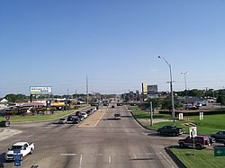
State Highway 360 is a 28-mile (45 km) north–south state highway in the Dallas–Fort Worth metroplex in the U.S. state of Texas. It runs north from an at-grade intersection with US 287 in Mansfield, near the Ellis-Johnson county line to a partial interchange with SH 121 in Grapevine, near Dallas/Fort Worth International Airport. The highway serves as a local north–south route running through the center of the metroplex, linking together the southern and northern suburbs to the core. Between US 287 and Camp Wisdom Road/Sublett Road, SH 360 follows a pair of frontage roads along a four-lane tollway known as the 360 Tollway, a tollway operated by the NTTA. Between Camp Wisdom Road/Sublett Road and SH 121, SH 360 follows a toll-free freeway maintained by TxDOT.

<span class="mw-page-title-main">Texas State Highway 40</span> State highway in Texas

State Highway 40 or William D. Fitch Parkway, runs from Farm to Market Road 2154 (FM 2154) to SH 6 in College Station, Texas. The current SH 40 was authorized in 1994. Signage for the highway went up March 2006 and the road was officially opened June 23, 2006.

<span class="mw-page-title-main">Texas State Highway 10</span> State highway in Tarrant County, Texas

State Highway 10 (SH 10) runs from SH 183 in Euless to the intersection of I-820, SH 121 and SH 183 in Hurst. This highway was created when a portion of SH 183 was rerouted on August 29, 1979. It is locally known as Hurst Boulevard and Euless Boulevard. It passes near the main facility of Bell Helicopter Textron.

<span class="mw-page-title-main">Texas State Highway 15</span> Highway in Texas

State Highway 15 is a state highway in the U.S. state of Texas. It runs from the Oklahoma state line 6 miles (9.7 km) east of Follett to US 287 in Stratford.

The President George Bush Turnpike (PGBT) is a 52-mile (84 km) toll road running through the northern, northeastern and western suburbs, forming a partial loop around Dallas, Texas, United States. It is named for the late George H. W. Bush, the 41st president of the United States. At its west end near Belt Line Road in Irving, State Highway 161 continues southwest to Interstate 20 (I-20) in Grand Prairie. The discontinuous free frontage roads along the turnpike from I-35E in Carrollton east to its end at I-30 in Garland are assigned the State Highway 190 designation. SH 190 signage appears only along the Rowlett, Garland, Richardson, Plano, and Carrollton sections of the frontage road with the undersign "frontage road only". At intersections with city streets, only the Bush Turnpike signs are displayed, not the SH 190 signage. Prior to the construction of the main lanes as a tollway, SH 190 was used as the name of the planned main lanes too. Similarly, the part west of I-35E was planned as part of SH 161. Bush Turnpike is signed as a north–south road from I-20 to I-35E, an east–west road from I-35E to the Merritt Main Lane Gantry and as a north–south road from the Merritt Main Lane Gantry to I-30, as Bush Turnpike makes a nearly 90-degree curve in both places.

<span class="mw-page-title-main">Texas State Highway 19</span> State highway in Texas

State Highway 19 is a state highway in Texas runs from Huntsville to Paris in east Texas.

<span class="mw-page-title-main">Texas State Highway 24</span> State highway in Texas

State Highway 24 runs from Campbell to Paris in north Texas. It is a portion of the main route, along with Interstate 30, from Paris to the Dallas–Fort Worth metroplex.

<span class="mw-page-title-main">Texas State Highway 183</span> Highway in Texas

State Highway 183 is a state highway in the Dallas–Fort Worth metroplex in Texas. Its most heavily used section is designated Airport Freeway where it serves the southern entrance of Dallas–Fort Worth International Airport.

<span class="mw-page-title-main">Texas State Highway 114</span> State highway in Texas, United States

State Highway 114 is a state highway that runs from the Dallas-Fort Worth Metroplex westward across Texas to the New Mexico state line, where it becomes New Mexico State Road 114, which eventually ends at Elida, New Mexico at US 70 / NM 330.

<span class="mw-page-title-main">Texas State Highway 78</span> State highway in Texas

State Highway 78 is a state highway that follows surface roads in a predominantly southwest-to-northeast direction in the Dallas area before traveling 90 miles (145 km) north-northeast to the Oklahoma State border.

<span class="mw-page-title-main">Dallas North Tollway</span> Highway in Texas

The Dallas North Tollway is a 30.2-mile (49 km) controlled-access toll road operated by the North Texas Tollway Authority (NTTA), which runs from Interstate 35E near downtown Dallas, Texas (USA), to U.S. Highway 380, in Frisco, Texas.

<span class="mw-page-title-main">Interstate 635 (Texas)</span> Highway in Texas

Interstate 635 (I-635) is a 37-mile-long (60 km) partial loop around Dallas, Texas, in the United States between I-20 in Balch Springs and State Highway 121 (SH 121) at the north entrance of the Dallas/Fort Worth International Airport (DFW Airport) in Grapevine. It intersects I-35E at exits 27B and 27C, but does not connect with I-35W. I-635 and a part of I-20 are collectively designated as the Lyndon B. Johnson Freeway; known locally as the LBJ Freeway, or simply LBJ. The roadway is named after Lyndon B. Johnson, the former US Senator from Texas, 37th Vice President, and the 36th President of the United States. Where I-635 ends at I-20, I-20 continues the LBJ Freeway designation heading west. Since the portion of I-20 between State Highway Spur 408 (Spur 408) to I-635 retains the same names as I-635, the two highways are considered 3/4 of the beltway around Dallas. Together with Spur 408, a portion of State Highway Loop 12, and a portion of I-35E, the Stemmons Freeway, I-635 and I-20 complete the beltway.

<span class="mw-page-title-main">Texas State Highway 170</span> Highway in Texas

State Highway 170 (SH 170), also known as the Alliance Gateway Freeway, is a Texas state highway in the northern suburbs of Fort Worth in the Alliance area. The highway was designated in 1988.

<span class="mw-page-title-main">Farm to Market Road 423</span> Highway in Texas

Farm to Market Road 423 is a farm to market road in Denton County, Texas.

<span class="mw-page-title-main">Farm to Market Road 1171</span>

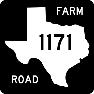
Farm to Market Road 1171 is a farm to market road in Denton County, Texas.

<span class="mw-page-title-main">U.S. Route 75 in Texas</span> Highway in Texas

U.S. Highway 75 (US 75) is a part of the U.S. Highway System that travels from Interstate 345 (I-345) in Dallas, Texas northward to the Canadian border at Noyes, Minnesota. In the state of Texas it runs from I-345 in Dallas and heads north to the Oklahoma state line.

The Sam Rayburn Tollway is a tollway operated by the North Texas Tollway Authority that runs from Grapevine to McKinney. Its frontage roads are signed State Highway 121.

<span class="mw-page-title-main">Texas State Highway Spur 399</span>

Spur 399 is a short, limited-access spur highway located in Collin County, Texas, and connects State Highway 121 (SH 121) and the US Highway 75 to SH 5, in McKinney. The highway is just over a mile long, and was originally designated in 1964, but was redesignated in 1989.

Northwest Highway is a major highway/road in the Dallas-Fort Worth Metroplex area of Texas. The highway was originally built as the route of State Highway 114 into Dallas. The road has been the site of major development for almost half a decade, especially in Dallas. The route is known as other names at various points. This includes Northwest Parkway and Northwest Drive in Mesquite.

References

  1. Transportation Planning and Programming Division (n.d.). "State Highway No. 121". Highway Designation Files. Texas Department of Transportation . Retrieved June 15, 2010.
  2. http://www.ntta.org/NR/rdonlyres/3FFA8F0C-1525-445F-A169-8B47A341B396/0/NTTA_SWPCT_Brief.pdf", Southwest Parkway/Chisholm Trail Project Status Report March 2009 from the NTTA.
  3. http://www.wfaa.com/video/?z=y&nvid=344241 "Overpasses give non-stop route between Frisco and D/FW", WFAA-TV report, March 20, 2009.
  4. "Dallas Morning News | News for Dallas, Texas | Latest News". Archived from the original on March 2, 2007.
  5. http://www.stop121tolls.com Archived 2007-05-26 at the Wayback Machine
  6. http://www.texaskaos.com/showDiary.do?diaryId=3068
  7. http://www.star-telegram.com/251/story/94756.html [ bare URL ]
  8. "State Approves Local Recommendation on SH 121". Archived from the original on September 1, 2007.
  9. "Minutes" (PDF). publicdocs.txdot.gov. Texas Department of Transportation. March 14, 1927. Archived (PDF) from the original on January 22, 2018. Retrieved April 29, 2023.
  10. "Minutes" (PDF). publicdocs.txdot.gov. Texas Department of Transportation. April 24, 1928. Archived (PDF) from the original on January 23, 2018. Retrieved April 29, 2023.
  11. "Minutes" (PDF). publicdocs.txdot.gov. Texas Department of Transportation. July 15, 1935. Archived (PDF) from the original on October 20, 2017. Retrieved April 29, 2023.
  12. "Minutes" (PDF). publicdocs.txdot.gov. Texas Department of Transportation. January 23, 1939. Archived (PDF) from the original on October 22, 2017. Retrieved April 29, 2023.
  13. "Minutes" (PDF). publicdocs.txdot.gov. Texas Department of Transportation. February 21, 1938. Archived (PDF) from the original on October 21, 2017. Retrieved April 29, 2023.
  14. Texas State Highway Department. "Minute Orders of the October 4, 1973 Meeting of the Texas State Highway Department" (PDF). Austin: Texas State Highway Department. Retrieved April 29, 2023.
  15. Texas Department of Highways and Public Transportation. "Minute Orders of the August 29, 1985 Meeting of the Texas State Highway and Public Transportation Commission" (PDF). Austin: Texas Department of Highways and Public Transportation. Retrieved April 29, 2023.
  16. Google (September 30, 2013). "SH 121" (Map). Google Maps . Google. Retrieved September 30, 2013.
  17. 1 2 Transportation Planning and Programming Division (n.d.). "Business State Highway No. 121-D". Highway Designation Files. Texas Department of Transportation . Retrieved July 11, 2017.
  18. Transportation Planning and Programming Division (n.d.). "State Highway Loop No. 451". Highway Designation Files. Texas Department of Transportation . Retrieved July 11, 2017.
  19. Google (July 11, 2017). "Overview Map of Bus. SH 121-D" (Map). Google Maps . Google. Retrieved July 11, 2017.
  20. 1 2 Transportation Planning and Programming Division (n.d.). "Business State Highway No. 121-H". Highway Designation Files. Texas Department of Transportation . Retrieved July 11, 2017.
  21. Google (July 11, 2017). "Overview Map of Bus. SH 121-H" (Map). Google Maps . Google. Retrieved July 11, 2017.