
Larrea tridentata is known as creosote bush and greasewood as a plant, as chaparral, as a medicinal herb, and as gobernadora in Mexico. It is Spanish for "governess", due to its ability to secure more water by inhibiting the growth of nearby plants. In Sonora, it is more commonly called hediondilla.

Terrell County is a county in the U.S. state of Texas. As of the 2010 census, its population was 984, making it the eighth-least populous county in Texas, and the 37th-least populous county in the nation. Its county seat is the census-designated place of Sanderson; no incorporated municipalities are in the county. The county was named for Alexander W. Terrell, a Texas state senator.

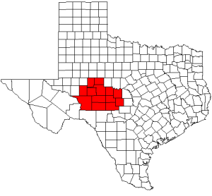
Presidio County is a county located in the U.S. state of Texas. As of the 2010 census, its population was 7,818. Its county seat is Marfa. The county was created in 1850 and later organized in 1875. Presidio County is in the Trans-Pecos region of West Texas and is named for the ancient border settlement of Presidio del Norte. It is on the Rio Grande, which forms the Mexican border.

Jeff Davis County is a county in the U.S. state of Texas. As of the 2010 census, its population was 2,342. Its county seat is Fort Davis. The county is named for Jefferson Davis, who served as the 23rd United States Secretary of War in the 1850s, and then, during the American Civil War, as President of the Confederate States of America. Jeff Davis County is easily recognizable for its unique shape; it is a pentagon which has no north-south nor east-west boundaries, save for a six mile line serving as its southern boundary. It also is the only county in the United States that touches a foreign country (Mexico) at a single point. Jeff Davis is also one of the nine counties that compose the Trans-Pecos region of West Texas.

Brewster County is a county located in the western part of the U.S. state of Texas. As of the 2010 census, the population was 9,232. Its county seat and only city is Alpine. The county is named for Colonel Henry Percy Brewster, a Secretary of War for the Republic of Texas.

Fort Davis is an unincorporated community and census-designated place (CDP) in Jeff Davis County, Texas, United States. The population was 1,201 at the 2010 census, up from 1,050 at the 2000 census. It is the county seat of Jeff Davis County. It was the site of Fort Davis, established in 1854 on the San Antonio–El Paso Road through west Texas and named after Jefferson Davis, who was then the Secretary of War under President Franklin Pierce.

Marfa is a city in the high desert of the Trans-Pecos in far West Texas, between the Davis Mountains and Big Bend National Park. It is the county seat of Presidio County, and its population as of the 2010 United States Census was 1,981. The city was founded in the early 1880s as a water stop; the population increased during World War II, but the growth stalled and reversed somewhat during the late 20th century. Today, Marfa is a tourist destination and a major center for minimalist art. Attractions include Building 98, the Chinati Foundation, artisan shops, historical architecture, a classic Texas town square, modern art installments, art galleries, Marfa lights, and Beebe.
The Southwestern United States, also known as the American Southwest, Desert Southwest, or simply The Southwest, is the informal name for a region of the western United States. Definitions of the region's boundaries vary a great deal and have never been standardized, though many boundaries have been proposed. For example, one definition includes the stretch from the Mojave Desert in California to Carlsbad, New Mexico, and from the Mexico–United States border to the southern areas of Colorado, Utah, and Nevada. The largest metropolitan areas are centered around Phoenix, Las Vegas, Tucson, Albuquerque, and El Paso. Those five metropolitan areas have an estimated total population of more than 9.6 million as of 2017, with nearly 60 percent of them living in the two Arizona cities—Phoenix and Tucson.

For the Texas State Park see Big Bend Ranch State Park.

The Chihuahuan Desert is a desert and ecoregion designation covering parts of northern Mexico and the southwestern United States. It occupies much of West Texas, parts of the middle and lower Rio Grande Valley and the lower Pecos Valley in New Mexico, and a portion of southeastern Arizona, as well as the central and northern portions of the Mexican Plateau. It is bordered on the west by the extensive Sierra Madre Occidental range, along with northwestern lowlands of the Sierra Madre Oriental range. On the Mexican side, it covers a large portion of the state of Chihuahua, along with portions of Coahuila, north-eastern Durango, the extreme northern part of Zacatecas, and small western portions of Nuevo León. With an area of about 362,000 km2 (139,769 sq mi), it is the second largest desert of the Americas and the largest in North America.

The desert cottontail, also known as Audubon's cottontail, is a New World cottontail rabbit, and a member of the family Leporidae. Unlike the European rabbit, they do not form social burrow systems, but compared with some other leporids, they are extremely tolerant of other individuals in their vicinity.

Hueco Tanks is an area of low mountains and historic site in El Paso County, Texas, in the United States. It is located in a high-altitude desert basin between the Franklin Mountains to the west and the Hueco Mountains to the east. Hueco is a Spanish word meaning hollows and refers to the many water-holding depressions in the boulders and rock faces throughout the region. Due to the unique concentration of historic artifacts, plants and wildlife, the site is under protection of Texas law; it is a crime to remove, alter, or destroy them.

The Spanish missions in Mexico are a series of religious outposts established by Spanish Catholic Franciscans, Jesuits, Augustinians, and Dominicans to spread the Christian doctrine among the local natives. Since 1493, the Kingdom of Spain had maintained a number of missions throughout Nueva España in order to preach the gospel to these lands. In 1533, at the request of Hernán Cortés, Carlos V sent the first Franciscan friarss with orders to establish a series of installations throughout the country.

The geography of Texas is diverse and large. Occupying about 7% of the total water and land area of the U.S., it is the second largest state after Alaska, and is the southernmost part of the Great Plains, which end in the south against the folded Sierra Madre Oriental of Mexico. Texas is in the South Central United States of America, and is considered to form part of the U.S. South and also part of the U.S. Southwest.

The Centennial Museum and Chihuahuan Desert Gardens is a cultural history and natural history museum on the campus of the University of Texas at El Paso in El Paso, Texas, United States.
Salvatore "Sam" Maceo was a Sicilian immigrant and organized crime boss in Galveston, Texas in the United States. Because of his efforts, Galveston Island became a nationally known resort town during the early and mid 20th century, a period known as Galveston's Open Era. He and his brother, both Sicilian immigrants, owned numerous restaurant and casino venues including the now-vanished Hollywood Dinner Club and the Balinese Room. Sometimes known as the "Velvet Glove," Sam's smooth style and ability to influence people were legendary. He was able to wield influence comparable to an elected official and he held relationships with celebrities and politicians throughout Texas and the United States. During his lifetime he and his island home were known nationwide.

Big Bend Ranch State Park is a 311,000-acre (126,000 ha) state park located on the Rio Grande in Brewster and Presidio counties, Texas. It is the largest state park in Texas. The closest major town is Presidio, Texas, where the state park's head office is located.
Dos Palmas Spring is an artesian spring in Riverside County, California where it lies at the foot of the Orocopia Mountains. It is only one of several such springs in the area that create an oasis in the Colorado Desert there.
Concho Valley is a region in West Texas. The region takes its name from the, Concho River, "shell" in Spanish, named due to its abundance of freshwater mussels in the river.


