
Trinity County is a county located in the northwestern portion of the U.S. state of California. Trinity County is rugged, mountainous, heavily forested, and lies along the Trinity River within the Salmon and Klamath Mountains. It is also one of three counties in California with no incorporated cities.

Throckmorton County is a county located in the U.S. state of Texas. As of the 2020 census, its population was 1,440. Its county seat is Throckmorton. The county was created in 1858 and later organized in 1879. It is named for William Throckmorton, an early Collin County settler. Throckmorton County is one of four remaining prohibition, or entirely dry, counties in Texas.

Smith County is a county in the U.S. state of Texas. As of the 2020 census, its population was 233,479. Its county seat is Tyler. Smith County is named for James Smith, a general during the Texas Revolution.
Kaufman County is a county in the northeastern area of the U.S. state of Texas. As of the 2020 census, its population was 145,310. Its county seat is Kaufman. Both the county, established in 1848, and the city were named for David S. Kaufman, a U.S. Representative and diplomat from Texas. Kaufman County is part of the Dallas-Fort Worth-Arlington metropolitan statistical area.

Erath County is a county located in the U.S. state of Texas. According to the United States Census bureau its population was 42,545 in 2020. The county seat is Stephenville. The county is named for George Bernard Erath, an early surveyor and a soldier at the Battle of San Jacinto.
Denton County is located in the U.S. state of Texas. As of the 2020 census, its population was 906,422, making it the seventh-most populous county in Texas. The county seat is Denton. The county, which was named for John B. Denton, was established in 1846. Denton County constitutes part of the Dallas–Fort Worth metroplex. In 2007, it was one of the fastest-growing counties in the United States.

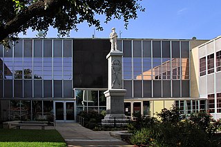
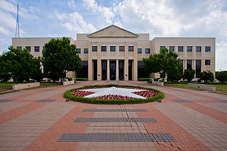
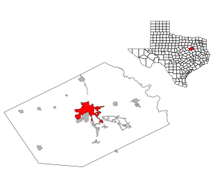
Collin County is located in the U.S. state of Texas. It is part of the Dallas-Fort Worth-Arlington metropolitan statistical area, and a small portion of the city of Dallas is in the county. At the 2020 United States census, the county's population is 1,064,465, making it the sixth-most populous county in Texas and the 43rd-largest county by population in the United States. Its county seat is McKinney.

Union Parish is a parish located in the north central section of the U.S. state of Louisiana. As of the 2020 census, the population was 21,107. The parish seat is Farmerville. The parish was created on March 13, 1839, from a section of Ouachita Parish. Its boundaries have changed four times since then.

Fairview is a town in Collin County, Texas, United States. It is part of the Dallas-Fort Worth metropolitan area. As of the 2017 census, the town population was 8,950. The estimated population in 2018 was 9,092. The town is adjacent to the 289-acre (1.17 km2) Heard Natural Science Museum and Wildlife Sanctuary.

Princeton is a city in Collin County, Texas, United States. As of the 2010 census it had a population of 6,807, with an increase to 17,027 in 2020.

Jacksboro is a city in Jack County, Texas, in the United States. Its population was 4,184 at the 2020 census. U.S. Highways 281 and 380, and Texas State Highways 114 and 199 intersect at Jacksboro, which is the county seat of Jack County.
Corsicana is a city and the county seat of Navarro County, Texas, United States. It is located on Interstate 45, 56 miles northeast of Waco. Its population was 25,109 at the 2020 census. Corsicana is considered an important agribusiness center.

The Trinity River is a 710-mile (1,140 km) river, the longest with a watershed entirely within the U.S. state of Texas. It rises in extreme northern Texas, a few miles south of the Red River. The headwaters are separated by the high bluffs on the southern side of the Red River.
This article traces the history of Dallas, Texas,.
More than 1,500 African American officeholders served during the Reconstruction era (1865–1877) and in the years after Reconstruction before white supremacy, disenfranchisement, and the Democratic Party fully reasserted control in Southern states. Historian Canter Brown Jr. noted that in some states, such as Florida, the highest number of African Americans were elected or appointed to offices after the end of Reconstruction in 1877. The following is a partial list of notable African American officeholders from the end of the Civil War until before 1900. Dates listed are the year that a term states or the range of years served if multiple terms.
There are five county parks in Collin County, Texas.

Lavon Lake is a freshwater reservoir located in southeast Collin County, Texas, on the East Fork of the Trinity River near Wylie, off State Highway 78. It is commonly called Lake Lavon for commercial and recreational purposes, but Lavon Lake is its official name according to the U.S. Army Corps of Engineers. It was originally called Lavon Reservoir.

Edmund Rice, was an early settler to Massachusetts Bay Colony born in Suffolk, England. He lived in Stanstead, Suffolk and Berkhamsted, Hertfordshire before sailing with his family to America. He landed in the Colony in summer or fall of 1638, thought to be first living in the town of Watertown, Massachusetts. Shortly thereafter he was a founder of Sudbury in 1638, and later in life was one of the thirteen petitioners for the founding of Marlborough in 1656. He was a deacon in the Puritan Church, and served in town politics as a selectman and judge. He also served five years as a member of the Great and General Court, the combined colonial legislature and judicial court of Massachusetts.
Preston Trail, later known as the Old Preston Road, was a road created by the Republic of Texas in 1841 from Preston, Texas on the Red River south to Austin, Texas. This road closely followed an existing trail that led across the area that had been used for centuries. This road was a main transportation artery from Central Texas to North Texas in the latter half of the 19th century. Today, Texas State Highway 289 follows near this former road.
John Kettell was an early settler, cooper, and explorer in what is Maynard, Massachusetts and Stow, Massachusetts. Kettell's family was taken captive by Native Americans in King Philips War in 1676.

