Lowry Crossing, Texas

Last updated

Lowry Crossing, Texas
Collin County Texas Incorporated Areas Lowry Crossing highlighted.svg
Location of Lowry Crossing in Collin County, Texas
Coordinates: 33°10′1″N96°32′55″W / 33.16694°N 96.54861°W / 33.16694; -96.54861
Country United States
State Texas
County Collin
Area
[1]
  Total2.60 sq mi (6.74 km2)
  Land2.59 sq mi (6.72 km2)
  Water0.01 sq mi (0.02 km2)
Elevation
512 ft (156 m)
Population
 (2010)
  Total1,711
  Estimate 
(2019) [2]
1,727
  Density666.02/sq mi (257.11/km2)
Time zone UTC-6 (Central (CST))
  Summer (DST) UTC-5 (CDT)
FIPS code 48-44308 [3]
GNIS feature ID1384177 [4]
Website www.lowrycrossingtexas.org

Lowry Crossing is a city in Collin County, Texas, United States. The population was 1,711 at the 2010 census.

Contents

Geography

Lowry Crossing is located at 33°10′01″N96°32′55″W / 33.166948°N 96.548746°W / 33.166948; -96.548746 . [5]

According to the United States Census Bureau, the city has a total area of 2.8 square miles (7.3 km2), all land.

Demographics

Historical population
CensusPop.Note
1980 443
1990 86595.3%
2000 1,22942.1%
2010 1,71139.2%
2019 (est.)1,727 [2] 0.9%
U.S. Decennial Census [6]

At the 2000 census there were 1,229 people, 441 households, and 362 families living in the city. The population density was 440.8 inhabitants per square mile (170.2/km2). There were 456 housing units at an average density of 163.5 per square mile (63.1/km2). The racial makeup of the city was 93.98% White, 0.65% African American, 0.41% Native American, 0.73% Asian, 3.66% from other races, and 0.57% from two or more races. Hispanic or Latino of any race were 6.43%. [3]

Of the 441 households 43.1% had children under the age of 18 living with them, 71.4% were married couples living together, 7.0% had a female householder with no husband present, and 17.7% were non-families. 14.3% of households were one person and 2.3% were one person aged 65 or older. The average household size was 2.79 and the average family size was 3.08.

The age distribution was 28.4% under the age of 18, 5.9% from 18 to 24, 36.1% from 25 to 44, 24.2% from 45 to 64, and 5.5% 65 or older. The median age was 35 years. For every 100 females, there were 105.2 males. For every 100 females age 18 and over, there were 105.6 males.

The median household income was $67,222 and the median family income was $73,393. Males had a median income of $50,066 versus $31,563 for females. The per capita income for the city was $26,574. About 1.2% of families and 3.0% of the population were below the poverty line, including 2.9% of those under age 18 and 2.2% of those age 65 or over.

Related Research Articles

<span class="mw-page-title-main">Weippe, Idaho</span> City in Idaho, United States

Weippe is a city in Clearwater County, Idaho, United States. The population was 441 at the 2010 census, up from 411 in 2000. In September 1805, the starving Lewis and Clark Expedition first met the Nez Perce on the Weippe Prairie, south of the city.

<span class="mw-page-title-main">Frederika, Iowa</span> City in Iowa, United States

Frederika is a city in Bremer County, Iowa, United States. The population was 204 at the time of the 2020 census. It is named for Fredrika Bremer, the Swedish author, for whom the surrounding county was also named.

<span class="mw-page-title-main">Hills, Iowa</span> City in Iowa, United States

Hills is a city in Johnson County, Iowa, United States. It is part of the Iowa City, Iowa Metropolitan Statistical Area. The population was 863 at the time of the 2020 census. It is part of the Iowa City Community School District.

<span class="mw-page-title-main">Oyens, Iowa</span> City in Plymouth County, Iowa, United States

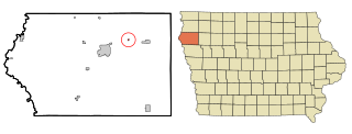
Oyens is a city in Plymouth County, Iowa, United States. The population was 92 at the time of the 2020 census.

<span class="mw-page-title-main">Sloan, Iowa</span> City in Iowa, United States

Sloan is a city in Woodbury County, Iowa, United States. It is part of the Sioux City, IA–NE–SD Metropolitan Statistical Area. The population was 1,042 at the time of the 2020 census.

<span class="mw-page-title-main">Broeck Pointe, Kentucky</span> City in Kentucky, United States

Broeck Pointe is a home rule-class city in Jefferson County, Kentucky, United States. The population was 272 at the 2010 census.

<span class="mw-page-title-main">Norbourne Estates, Kentucky</span> City in Kentucky, United States

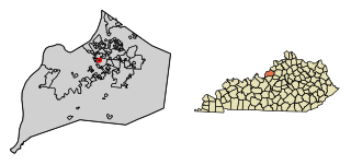
Norbourne Estates is a home rule-class city in Jefferson County, Kentucky, United States. The population was 441 at the 2010 census.

<span class="mw-page-title-main">Solway, Minnesota</span> City in Minnesota, United States

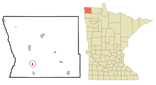
Solway is a city in Beltrami County, Minnesota, United States. The population was 96 at the 2010 census. Solway serves as a bedroom community for nearby Bemidji.

<span class="mw-page-title-main">Vermillion, Minnesota</span> City in Minnesota, United States

Vermillion is a city in Dakota County, Minnesota, United States. The population was 441 at the 2020 census.

<span class="mw-page-title-main">Kennedy, Minnesota</span> City in Minnesota, United States

Kennedy is a city in Kittson County, Minnesota, United States. The population was 176 at the 2020 census.

<span class="mw-page-title-main">Viking, Minnesota</span> City in Minnesota, United States

Viking is a city in Marshall County, Minnesota, United States. The population was 79 at the 2020 census.

<span class="mw-page-title-main">Lowry, Minnesota</span> City in Minnesota, United States

Lowry is a city in Pope County, Minnesota, United States. The population was 334 at the 2020 census.

<span class="mw-page-title-main">Crystal Lake Park, Missouri</span> City in Missouri, United States

Crystal Lake Park is a Missouri Class 4 city in St. Louis County, Missouri, United States. The population was 508 at the 2020 census.

<span class="mw-page-title-main">Briarwood, North Dakota</span> City in North Dakota, United States

Briarwood is a city in Cass County, North Dakota, United States. The population was 57 at the 2020 census. Briarwood was founded in 1973. It is a suburb directly adjacent to the city of Fargo.

<span class="mw-page-title-main">Yoncalla, Oregon</span> City in Oregon, United States

Yoncalla is a city in Douglas County, Oregon, United States. The population was 1,047 at the 2010 census.

<span class="mw-page-title-main">Berea, South Carolina</span> CDP in South Carolina, United States

Berea is a census-designated place (CDP) in Greenville County, South Carolina, United States. The population was 14,295 at the 2010 census. It is part of the Greenville–Mauldin–Easley Metropolitan Statistical Area.

<span class="mw-page-title-main">Morgan, Texas</span> City in Texas, United States

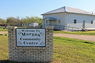
Morgan is a city in Bosque County in Central Texas, United States. The city's population was 490 at the 2010 census.

<span class="mw-page-title-main">Rose Hill Acres, Texas</span> City in Texas, United States

Rose Hill Acres is a city in Hardin County, Texas, United States. The population was 441 at the 2010 census, down from 480 at the 2000 census. The city consists of two residential neighborhoods situated between Beaumont and Lumberton. It is part of the Beaumont–Port Arthur Metropolitan Statistical Area. Rose Hill Acres has a small government structure led by Mayor David Lang.

<span class="mw-page-title-main">Ropesville, Texas</span> City in Texas, United States

Ropesville is a city in Hockley County, Texas, United States. Its population was 434 at the 2010 census, down from 517 at the 2000 census.

<span class="mw-page-title-main">Newburg, West Virginia</span> Town in West Virginia, United States

Newburg is a town in western Preston County, West Virginia, United States. The population was 275 at the 2020 census. It is part of the Morgantown metropolitan area.

References

  1. "2019 U.S. Gazetteer Files". United States Census Bureau. Retrieved August 7, 2020.
  2. 1 2 "Population and Housing Unit Estimates". United States Census Bureau. May 24, 2020. Retrieved May 27, 2020.
  3. 1 2 "U.S. Census website". United States Census Bureau . Retrieved January 31, 2008.
  4. "US Board on Geographic Names". United States Geological Survey. October 25, 2007. Retrieved January 31, 2008.
  5. "US Gazetteer files: 2010, 2000, and 1990". United States Census Bureau. February 12, 2011. Retrieved April 23, 2011.
  6. "Census of Population and Housing". Census.gov. Retrieved June 4, 2015.