Hughes County is a county in the U.S. state of South Dakota. As of the 2010 United States Census, the population was 17,022, making it the least populous capital county in the nation, and the twelfth-most populous county in South Dakota. Its county seat is Pierre, which is also the state capital. The county was created in 1873, and was organized in 1880. It was named for Alexander Hughes, a legislator. On 4 June 1891, the county's area was increased by the addition of Farm Island, in the Missouri River downstream of Pierre.

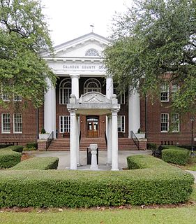
Georgetown County is a county located in the U.S. state of South Carolina. As of the 2010 census, the population was 60,158. Its county seat is Georgetown. The county was founded in 1769. It is named for George III of the United Kingdom.

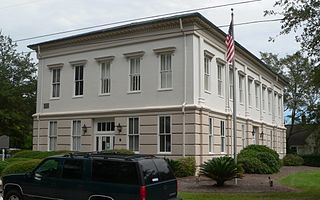
Moncks Corner is a town in and the county seat of Berkeley County, South Carolina, United States. The population was 7,885 at the 2010 census. As defined by the U.S. Census Bureau, Moncks Corner is included within the Charleston–North Charleston–Summerville Metropolitan Statistical Area.

Summerton is a town in Clarendon County, South Carolina, United States. The population was 1,000 at the 2010 census.
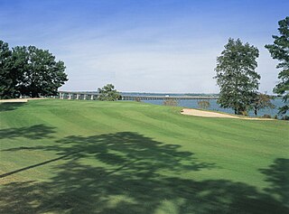
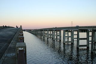
Santee is a town in Orangeburg County along the Santee River Valley in central South Carolina, United States. It has become a resort town of note located centrally north-south along the Atlantic Seaboard of South Carolina. The region has been rural, with a primarily agricultural economy typical of Orangeburg County, but is now known primarily for its several golf courses in proximity to Lake Marion, Santee State Park and other Lake Marion attractions. Interstate 95 connects its attractions easily with tourists traveling by automobile. I-95 crosses a narrow arm of the lake into the town lands, along a causeway. Lake Marion is a man-made hydroelectric reservoir, which at 110,000 acres is one of the fifty largest lakes in the country.
The Santee River is a river in South Carolina in the United States, and is 143 miles (230 km) long. The Santee and its tributaries provide the principal drainage for the coastal areas of southeastern South Carolina and navigation for the central coastal plain of South Carolina, emptying into the Atlantic Ocean approximately 440 miles (708 km) from its farthest headwater on the Catawba River in North Carolina. The Santee River is the second largest river on the eastern coast of the United States, second only to the Susquehanna River in drainage area and flow. Much of the upper river is impounded by the expansive, horn-shaped Lake Marion reservoir, formed by the 8-mile (13 km)-long Santee Dam. The dam was built during the Great Depression of the 1930s as a Works Progress Administration (WPA) project to provide a major source of hydroelectric power for the state of South Carolina.
The Olde English District is one of eleven tourism districts of South Carolina encompassing Chester, Chesterfield, Fairfield, Kershaw, Lancaster, and York counties as well as the cities and towns of Camden, Chester, Chesterfield, Clover, Kershaw, Lancaster, Pageland, Rock Hill, Winnsboro, and York.
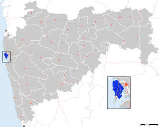
Mumbai Suburban District is a district of Maharashtra in Konkan Division. Its headquarters is in Bandra. It consists of three administrative subdivisions : Kurla, Andheri, and Borivali. The district along with Mumbai City district and other suburban communities make up the metropolis of Mumbai on Salsette Island. The district occupies an area of 446 km².

Carrot River is a town located in northeast Saskatchewan in Canada. The administration office for the Rural Municipality of Moose Range #486 is located in Carrot River.
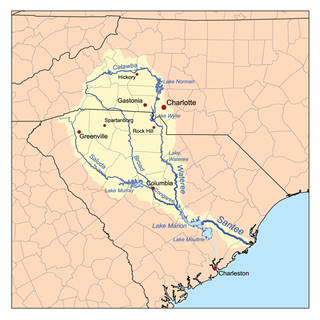
The Wateree River, about 75 mi (120 km) long, is a tributary of the Santee River in central South Carolina in the United States, which flows to the Atlantic Ocean. Its name recalls the now-extinct Wateree Native Americans, who lived in the area until displaced by European settlers.
Santee Cooper, also known officially from the 1930s as the South Carolina Public Service Authority, is South Carolina's state-owned electric and water utility that came into being during the New Deal as both a rural electrification and public works project that created two lakes and cleared large tracts of land while building hydro-electric dams and power plants. Its headquarters are located in Moncks Corner, South Carolina.

"Kiamichi Country" was the Oklahoma Department of Tourism and Recreation's official tourism designation for Southeastern Oklahoma until the name was changed to Choctaw Country in honor of the Choctaw Nation headquartered there. The current definition of Choctaw Country includes ten counties, being Coal, Atoka, Bryan, Choctaw, McCurtain, Pushmataha, Le Flore, Latimer, Haskell, and Pittsburg Counties. The Department created the term as one of six designated travel regions within the state. However, other definitions of Southeastern Oklahoma may include additional counties.

The Palmetto Trail is a planned 425-mile-long (684 km) foot and mountain bike trail in South Carolina for recreational hiking and biking. Several of the sections are also equestrian trails. It will extend from the Oconee County mountains to the Intracoastal Waterway in Charleston County. It currently consists of 23 segments totaling 235 miles (378 km). Maps and trail guides are available.

South Central Oklahoma is an amorphous region in the state of Oklahoma, perhaps encompassing 10 counties. It is centered on the Arbuckle Mountains, an ancient, eroded range traversing some 70 miles (110 km) across the region, and surrounded by rivers and lakes, notably Lake Texoma, Lake Murray and Lake of the Arbuckles. For tourism purposes, the Oklahoma Department of Tourism has more narrowly defined South Central Oklahoma, which they refer to as Chickasaw Country, as being a seven-county region including Pontotoc, Johnston, Marshall, Garvin, Murray, Carter, and Love counties. A ten-county definition might also include Coal, Atoka, and Bryan counties, although the Department of Tourism includes those in Choctaw Country. The Choctaw Nation of Oklahoma covers the eastern third of the region. Its headquarters is in Durant, and its capitol building, now a museum, is in Tuskahoma. The Chickasaw Nation lies within the region, with the tribal capitol building located at Tishomingo and its headquarters in Ada. The Chickasaw Nation, which runs "Chickasawcountry.com"., promotes the idea of Chickasaw Country as the 13 south-central Oklahoma counties that comprise the Chickasaw Nation, being the Tourism Department’s seven counties plus Coal, Bryan, Jefferson, Stephens, Grady, and McClain counties.

The High Hills of Santee, sometimes known as the High Hills of the Santee, is a long, narrow hilly region in the western part of Sumter County, South Carolina. It has been called "one of the state's most famous areas". The High Hills of Santee region lies north of the Santee River and east of the Wateree River, one of the two rivers that join to form the Santee. It extends north almost to the Kershaw county line and northeasterly to include the former summer resort town of Bradford Springs. Since 1902 the town has been included in Lee County.

Pinopolis Dam is a dam in Berkeley County, South Carolina.
Ferguson is a ghost town, a former lumber-mill settlement, in Orangeburg County, South Carolina. It was a company town owned by Northern lumbermen Francis Beidler and Benjamin F. Ferguson of Chicago. The co-CEOs founded the Santee River Cypress Lumber Company in 1881 for the purpose of harvesting old-growth timber from blackwater river wetlands in central South Carolina. The firm, which controlled 165,000 acres (67,000 ha) of land, concentrated its efforts on bald cypress timber.