
Elkridge is an unincorporated community and census-designated place (CDP) in Howard County, Maryland, United States. The population was 15,593 at the 2010 census. Founded early in the 18th century, Elkridge is adjacent to two other counties, Anne Arundel and Baltimore.

Guilford is an unincorporated community located in Howard County in the state of Maryland. The location is named after the Guilford Mill. Guilford is near Kings Contrivance, one of the nine "villages" of Columbia.

George Howard was the 22nd Governor of the State of Maryland in the United States from 1831 to 1833. Howard was well known as a fervent anti-Jacksonian during his term in office. He was the only son of a governor to have been elected governor.

Savage is an unincorporated community and census-designated place located in Howard County, Maryland, United States, approximately 18 miles (29 km) south of Baltimore and 21 miles (34 km) north of Washington, D.C. It is situated close to the city of Laurel and to the planned community of Columbia. As of the 2010 census it had a population of 7,054. The former mill town is a registered historic place, and has many original buildings preserved within and around the Savage Mill Historic District.

Oakland Mills is one of the 10 villages in Columbia, Maryland, United States. It is located immediately east of Town Center, across U.S. Route 29.

The Savage Mill is a historic cotton mill complex in Savage, Maryland, which has been turned into a complex of shops and restaurants. It was placed on the National Register of Historic Places in 1974. It is located in the Savage Mill Historic District. Buildings in the complex date from 1822 to 1916.
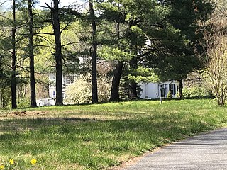
The Commodore Joshua Barney House is a historic home located at Savage, Howard County, Maryland, United States. It was originally situated on a 700-acre tract in modern Savage Maryland named Harry's Lot, at a time when the closest town was Elk Ridge. Both "Haary's Lot" and "Huntington Quarter" were inherited by Charles Greenberry Ridgely, sixth son of Colonel Henry Ridgley and Elizabeth Warfield Ridgley. After the death of Charles Greenberry Ridgely, Thomas Coale purchased portions of the land containing the structure. His daughter would become the famous Commodore Joshua Barney's second wife, bringing the figure from business in Baltimore. In 1809, Nathaniel F. Williams (1782-1864) married Caroline Barney, daughter of Joshua Barney, who in turn expanded an existing mill site on the property to create the Savage Mill.

Richland Farm is a historic home and farm complex located at Clarksville, Howard County, Maryland, United States. The main house is a log and frame house, the earliest section of which is presumed to date from 1719. The main block comprises three sections, with a large addition on the rear added in 1920. It features a one-story shed-roofed wrap-around porch supported by 22 Doric order columns. Also on the property are the Overseer's/Superintendent's House, Gardener's Cottage, wagon shed, tractor shed and smokehouse with board-and-batten siding, a bank barn, a stone spring house and “Barrack.”

South River Club refers to both a social club located just south of Annapolis, Maryland and to the historic building in Anne Arundel County, Maryland where the club meets.
The Colonial families of Maryland were the leading families in the Province of Maryland. Several also had interests in the Colony of Virginia, and the two are sometimes referred to as the Chesapeake Colonies.

Joseph Dorsey House was a historic building in West Brownsville, Pennsylvania. It is designated as a historic residential landmark/farmstead by the Washington County History & Landmarks Foundation.
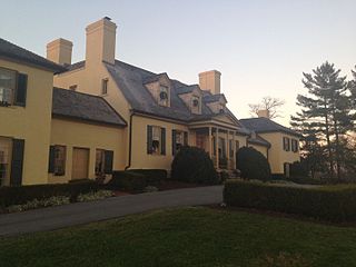
The Belmont Estate, now Belmont Manor and Historic Park, is a former forced-labor farm located at Elkridge, Howard County, Maryland, United States. Founded in the 1730s and known in the Colonial period as "Moore's Morning Choice", it was one of the earliest forced-labor farms in Howard County, Maryland. Its 1738 plantation house is one of the finest examples of Colonial Georgian architectural style in Maryland.

Ogle Hall is an historic building in Annapolis, Maryland, Maryland Inventory of Historic Properties Inventory #AA-530. It is also known as the United States Naval Academy Alumni House.
Thomas Beale Dorsey (1780–1855) was an American farmer, lawyer, politician and judge serving Anne Arundel County and Maryland.
Dr. Charles Alexander Warfield (1751–1813) was a prominent American in the Howard District of Anne Arundel County Maryland. He was president of the board of regents of the Maryland Agriculture College from 1812 to 1813.

The Simpsonville Mill is a historic pre-colonial mill complex in Simpsonville, Maryland, part of the Columbia, Maryland land development.
Elioak is an unincorporated community in Howard County, Maryland, United States. It was the home of the "Pushpin Farm", a 200-acre slave plantation purchased in 1724 in the Howard District of Anne Arundel County by Col. Edward Dorsey and which is the site of many prominent Dorsey family graves. The postal community was named after the Elioak plantation built by Owen Dorsey, Judge of the Baltimore Orphans' Court. A postal office operated in the community from 12 June 1893 to 15 September 1922. Local farm orchards were known for prize winning apples and pears. Local families such as the Kahler, Miller, and Worthington claimed Elioak as home while they served in World War I. After the war, the name fell out of use.
Worthington's Quarters, White Hall, Glen Burnie, Iris Hill, is a historic forced-labor farm in Columbia in Howard County, Maryland, United States.

Col. Edward Dorsey was a colonial settler of Maryland and Anne Arundel County. His house at 211 Prince George St. is a historic Annapolis home, once occupied by Francis Nicholson from 1694 to 1709.
Joseph Noble Stockett was prominent Maryland landowner during the late 18th and early 19th century.


