Related Research Articles
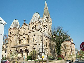
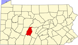
Blair County is a county in the Commonwealth of Pennsylvania. As of the 2020 census, the population was 122,822. Its county seat is Hollidaysburg. The county was created on February 26, 1846, from parts of Huntingdon and Bedford counties.

Catharine Township is a township in Blair County, Pennsylvania, United States. The population was 774 at the 2020 census. It is part of the Altoona, PA Metropolitan Statistical Area.

Frankstown Township is a township in Blair County, Pennsylvania, United States. It is part of the Altoona Metropolitan Statistical Area. The population was 7,399 at the 2020 census. The township was named after Stephen Franks, a pioneer citizen.

Snyder Township is a township in Blair County, Pennsylvania, United States. It is part of the Altoona, PA Metropolitan Statistical Area. The population was 3,360 at the 2020 census.

Tyrone Township is a township in Blair County, Pennsylvania. It is part of the Altoona, PA Metropolitan Statistical Area. The population was 1,882 at the 2020 census.

Cherry Run is a 7.2-mile-long (11.6 km) meandering stream that forms the northern section of the boundary between Morgan and Berkeley counties in West Virginia's Eastern Panhandle. While it is mostly non-navigable, Cherry Run provides many pools of varying depths for fishing and swimming. As a tributary of the Potomac River, Cherry Run is part of the Potomac and Chesapeake Bay watersheds.

Summit Lawn is a small unincorporated village in Lehigh County, Pennsylvania. Summit Lawn is part of the Lehigh Valley, which has a population of 861,899 and is the 68th most populous metropolitan area in the U.S. as of the 2020 census.
Bald Eagle is an unincorporated populated place in Blair County, Pennsylvania, United States. It is located in the Bald Eagle Valley at the foot of the Bald Eagle Mountain ridge, along the Big Fill Run near its confluence with the headwaters of the Bald Eagle Creek tributary of the Little Juniata River. Originally a stop on the Pennsylvania Railroad Tyrone Division, it is now exit 52 off of Interstate 99, and was the former northern terminus of the unfinished highway. The Bald Eagle postal zip code is 16686.
Lanark is a small unincorporated village located in Upper Saucon Township in Lehigh County, Pennsylvania. It is part of the Lehigh Valley, the third largest metropolitan area in Pennsylvania.

Brownsville is an unincorporated community located in western Lower Heidelberg Township, Berks County, Pennsylvania, United States. It is located at the intersection of Brownsville and Heffner Roads. A very small portion of the village extends into North Heidelberg Township.

Tyrone Township is a civil township of Livingston County in the U.S. state of Michigan. The population was 10,020 at the 2010 census, up from 8,459 at the 2000 census.
Gilmer Park is an unincorporated community in Centre Township, St. Joseph County, in the U.S. state of Indiana.
Muren is an unincorporated community in Patoka Township, Pike County, in the U.S. state of Indiana.

Arch Springs is an unincorporated community located in Tyrone Township, Blair County, Pennsylvania. It is located on Kettle Road approximately 0.3 miles to the south of Hileman Road. Sinking Run flows through the community, and the Arch Spring itself is located on the creek.
Culp is an unincorporated community located in Tyrone Township, Blair County, Pennsylvania. It is located on Kettle Road at the intersection with Golf Course Road.
Jackson Heights is an unincorporated community in Warren Township, Jefferson County, Ohio, United States. It is located west of Tiltonsville on Jackson Heights Road, at 40°10′32″N80°42′14″W.
Grandview Heights is an unincorporated community in Warren Township, Jefferson County, Ohio, United States. It is located just west of Tiltonsville on Jackson Heights Road, at 40°10′14″N80°42′33″W.
McIntyre is an unincorporated community in Wayne Township, Jefferson County, Ohio, United States. It is located southeast of Bloomingdale and just east of Chandler along Township Road 191, at 40°18′24″N80°46′52″W.
Newell is an unincorporated community in Smithfield Township, Jefferson County, Ohio, United States. It is located west of Smithfield and just northwest of Piney Fork at the intersection of Piney Fork Road and Newell Road, at 40°15′37″N80°50′10″W.
Shady Glen is an unincorporated community in Knox Township, Jefferson County, Ohio, United States. It is located west of Calumet along the John F. Kennedy Highway at its intersection with Brandywine Road, at 40°28′48″N80°38′23″W.
References
- ↑ Tyrone Township PennDOT Map
Coordinates: 40°37′11″N78°16′08″W / 40.61972°N 78.26889°W
| | This Blair County, Pennsylvania state location article is a stub. You can help Wikipedia by expanding it. |