Skirling

Last updated

Skirling
Scottish Borders UK location map.svg
Red pog.svg
Skirling
Location within the Scottish Borders
Population194 
OS grid reference NT0753139017
Council area
Lieutenancy area
Country Scotland
Sovereign state United Kingdom
Post town Biggar
Postcode district ML12
Dialling code 01721
Police Scotland
Fire Scottish
Ambulance Scottish
UK Parliament
Scottish Parliament
List of places
UK
Scotland
55°38′09″N3°28′14″W / 55.635882°N 3.4704351°W / 55.635882; -3.4704351 Coordinates: 55°38′09″N3°28′14″W / 55.635882°N 3.4704351°W / 55.635882; -3.4704351

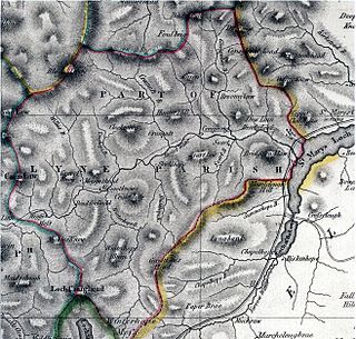
Skirling is a parish, community council area and village in Peeblesshire in the Scottish Borders situated 2+12 miles east of Biggar in Lanarkshire. Biggar Water, a tributary the River Tweed forms the southern boundary of the parish with the parish of Broughton, Glenholm and Kilbucho. It is also bounded by that parish on the east, namely the Broughton part of it. On the north it is bounded by the parish Kirkurd in Peeblesshire. Spittal Burn forms most of its western boundary with Lanarkshire. [1]

Parish of Skirling, 1900 Map of Skirling, Peeblesshire.jpg
Parish of Skirling, 1900

The parish lies in the Southern Uplands. Its village is 690 ft above sea level. Its length, north to south, is 3 miles and it is 2 miles at most wide. [1] [2] The highest point in the parish is Broomy Law, 1399 ft, [3] on the north-west boundary. At its northernmost point the parish is met by 5 other parishes (boundary stone at site).

The earliest known record of Skirling by name dates from the reign of King Robert Bruce, who granted the barony of Scrawline to John Monfode. [2] The barony of Skirling was possessed by the Cockburn family c.1370 - 1621 and during the 18th and 19th centuries by the Carmichael family. [1] Thomas Gibson-Carmichael was raised to peerage of the United Kingdom in 1912 as Baron Carmichael of Skirling, but this title became extinct on his death in 1926. He commissioned the building of Skirling House in 1905. [4]

Skirling Kirk Skirling Parish Church - geograph.org.uk - 991801.jpg
Skirling Kirk

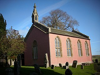
The earliest record of a church is in 1275, sited near the present war memorial. [5] Former ministers include John Greig. [6] In 1843, William Hanna left the established Church of Scotland in 1843, joining the Free Church of Scotland, taking most of his congregation with him. [7] The present building was rebuilt in 1720 and was much altered in 1891. It has a pleasant bell tower with a sundial, the bell dating from 1748. [8] Ironwork on the graveyard gates is by Thomas Hadden and the Carmichael family plot is flanked by two charming angel sculptures. The church is now a member of the linked "Parishes of Upper Tweeddale", which is made up of four neighbouring Parishes. [5]

The Skirling Community Council area is the same as the civil parish. The council has 6 members. [9]

The village of Skirling has a central position in the parish. It originally consisted of five small farms on the valley floor of Skirling Burn, forming a roughly linear shaped settlement. The village is a conservation area, [10] which includes the parish church, the old Free church, Skirling House, along with many 1 - 2 story buildings made from traditional materials. Just south-west of the village is the site of Skirling Castle, described as "ane notable beilding" [11] and demolished and burnt by Regent Moray on 12 June 1568. [1]

The village war memorial was designed by Sir Robert Lorimer and added in 1920. [12]

The civil parish has a population of 194 (in 2011) [13] and its area is 3,423 acres. [14]

At 11.18am on 31 December 2020 Skirling was the epicentre of a 1.9 Magnitude earthquake which was also felt in Biggar, Symington, West Linton and Peebles. Locals reported that they heard a "loud bang" or "loud rumbling noise" and that the "room shuddered". [15]

Related Research Articles

<span class="mw-page-title-main">Peeblesshire</span> Historic county in Scotland

Peeblesshire, the County of Peebles or Tweeddale is a historic county of Scotland. Its county town is Peebles, and it borders Midlothian to the north, Selkirkshire to the east, Dumfriesshire to the south, and Lanarkshire to the west.

<span class="mw-page-title-main">Selkirkshire</span> Historic county = in Scotland

Selkirkshire or the County of Selkirk is a historic county and registration county of Scotland. It borders Peeblesshire to the west, Midlothian to the north, Roxburghshire to the east, and Dumfriesshire to the south. It derives its name from its county town, the royal burgh of Selkirk. The county was historically also known as Ettrick Forest.

<span class="mw-page-title-main">Coldingham</span> Human settlement in Scotland

Coldingham is a village and parish in Scottish Borders, on Scotland's southeast coastline, north of Eyemouth.

<span class="mw-page-title-main">Kilbucho</span> Village in Scotland

Kilbucho is a small settlement in the parish of Broughton, Glenholm and Kilbucho in the Scottish Borders area of Scotland in Peeblesshire and near Biggar and Broughton.

<span class="mw-page-title-main">Broughton, Scottish Borders</span>

Broughton is a village in Tweeddale in the historical county of Peeblesshire in the Scottish Borders council area, in the south of Scotland, in the civil parish of Broughton, Glenholm and Kilbucho and Upper Tweed Community Council. Broughton is on the Biggar Water, near where it flows into the River Tweed. It is about 7 km east of Biggar, and 15 km west of Peebles.

<span class="mw-page-title-main">Thomas Gibson-Carmichael, 1st Baron Carmichael</span> Scottish politician and colonial administrator (1859–1926)

Thomas David Gibson-Carmichael, 1st Baron Carmichael,, known as Sir Thomas Gibson-Carmichael, 11th Baronet, between 1891 and 1912, was a Scottish Liberal politician and colonial administrator. He was also a keen naturalist.

<span class="mw-page-title-main">Rosewell, Midlothian</span> Village in Midlothian, Scotland

Rosewell is a former mining village in Midlothian, Scotland, east of Roslin and south-west of Bonnyrigg. The village is in the civil parish of Lasswade and was previously a separate ecclesiastical parish, but has its own Community Council, namely Rosewell and District.

Minto is a village and parish in the Scottish Borders area of Scotland in Roxburghshire county. It is located 6 miles north-east of Hawick, north of the River Teviot.

<span class="mw-page-title-main">Symington, South Lanarkshire</span> Human settlement in Scotland

Symington is a small village in South Lanarkshire, Scotland, 3 miles (5 km) southwest of Biggar, 10 miles (16 km) east of Douglas and 13 miles (21 km) southeast of Carluke. Geographical features near Symington include Tinto Hill, the Coulter Hills and the River Clyde. A map by Pont in 1596 showed two St John's Kirks in a small settlement, and another map by Roy in 1754 showed a mill to the east.

<span class="mw-page-title-main">Lyne, Scottish Borders</span>

Lyne is a small village and civil parish in the Scottish Borders area of Scotland, 4 miles (6.4 km) west of the market town of Peebles; it lies off the A72, in the old county of Peeblesshire and has an area of about 4 square miles (10 km2).

<span class="mw-page-title-main">Caddonfoot</span>

Caddonfoot is a village on the River Tweed, in the Scottish Borders area of Scotland, on the A707, near Galashiels.

<span class="mw-page-title-main">Cavers, Scottish Borders</span> Human settlement in Scotland

Cavers is a parish in the Scottish Borders area of Scotland, in the former county of Roxburghshire, south and east of Hawick. The largest village in the parish is Denholm.

<span class="mw-page-title-main">Sprouston</span> Human settlement in Scotland

Sprouston is a village, parish and former feudal barony in the Scottish Borders area of Scotland, as well as the historic county of Roxburghshire, located 2 miles north-east of Kelso.

<span class="mw-page-title-main">Yarrow, Scottish Borders</span> Human settlement in Scotland

Yarrow is a place and parish in the Scottish Borders area of Scotland and in the former county of Selkirkshire.The name "Yarrow" may derive from the Celtic word garw meaning "rough" or possibly share a derivation with the English name "Jarrow".

<span class="mw-page-title-main">Channelkirk</span> Human settlement in Scotland

Channelkirk is a parish and community council area in the north-west corner of the historic county of Berwickshire in the Scottish Borders area of Scotland, forming the upper part of the ancient district of Lauderdale, while the parish of Lauder forms the lower part. The Community Council has the name Oxton and Channelkirk, Oxton being the main village of the parish. It was formerly in the Ettrick and Lauderdale district of Borders Region. A small strip of land along the northern boundary of the parish was added to Ettrick and Lauderdale district and thus also to the community council area, in the Brothershiels area, in 1988.

<span class="mw-page-title-main">Cranston, Midlothian</span> Human settlement in Scotland

Cranston is a parish of Midlothian, Scotland, lying 4+14 miles south-east of Dalkeith. It is bounded by the parishes of Inveresk and Ormiston on the east, by Crichton and Borthwick on the south ; and by Newbattle on the west and north. The River Tyne flows through the centre of the parish.

Manor is a parish in Peeblesshire in the Scottish Borders, whose church lies on the west bank of Manor Water 3 miles south-west of Peebles.

<span class="mw-page-title-main">Kirkurd</span> Human settlement in Scotland

Kirkurd is a parish in Peeblesshire in the Scottish Borders situated 3 miles south-east of Dolphinton and 6 miles north-east of Broughton. Tarth Water, a tributary of Lyne Water forms the northern boundary, with the parishes of Linton and Newlands on the north bank. The parish of Stobo lies to the east and south, the parish of Broughton, Glenholm and Kilbucho to the south, Skirling and Dolphinton (Lanarkshire) to the east.

<span class="mw-page-title-main">Broughton, Glenholm and Kilbucho</span> Human settlement in Scotland

Broughton, Glenholm and Kilbucho is a parish in Peeblesshire in the Scottish Borders, 11 miles south-west of Peebles, lying in the upper part of the valley of the River Tweed in the Southern Uplands. It is a union of three former parishes of bearing these names and the united parish is bound by Kirkurd on the north, Stobo on the east, Drumelzier on the south-east, Culter and Biggar, South Lanarkshire on the west and by Skirling in the north-west. For 4½ miles the eastern border of the parish follows the northward flowing Tweed. It is 9½ miles long north-to-south and 3½ miles wide. The only village is Broughton.

<span class="mw-page-title-main">Megget</span> Human settlement in Scotland

Megget is a former chapelry or parish containing the valley of Megget Water, now forming the westernmost part of the parish of Yarrow, Selkirkshire in the Scottish Borders area of Scotland. The centre of the valley is 19 miles west of Selkirk.

References

  1. 1 2 3 4 Ordnance Gazetteer of Scotland, by Francis Groome, 2nd edition 1896; article on Skirling
  2. 1 2 Statistical Account of Scotland, Vol III Roxburgh, Peebles, Selkirk, publ.William Blackwood, 1845; article on Skirling (Peeblesshire section)
  3. Ordnance Survey 1 inch to 1 mile, Sheet 61 - Falkirk and Lanark, Publication date 1961
  4. Website of Historic Environment Scotland, formed in 2015 by the merger Historic Scotland and the Royal Commission on the Ancient and Historical Monuments of Scotland (RCAHMS): canmore.org.uk/site/97985 - retrieved Oct 2016
  5. 1 2 Church of Scotland website www.uppertweeddale.org.uk retrieved Oct 2016
  6. Scott, Hew (1915). Fasti ecclesiae scoticanae; the succession of ministers in the Church of Scotland from the reformation. Vol. 1. Edinburgh: Oliver and Boyd. pp.  257-259. Retrieved 17 March 2019.PD-icon.svg This article incorporates text from this source, which is in the public domain .
  7. "Hanna, William"  . Dictionary of National Biography . London: Smith, Elder & Co. 1885–1900.
  8. Historic Environment Scotland web site portal.historicenvironment.scot/designation/LB15153; retrieved Oct 2016
  9. Scottish Borders Community Council web site www.scotborders.gov.uk/downloads/file/1025/skirling; retrieved Oct 2016
  10. Scottish Borders council web site www.scotborders.gov.uk/directory_record/26011/skirling - Retrieved Oct 2016
  11. Calendar State Papers Scotland, vol. 2 (Edinburgh, 1900), pp. 444-5.
  12. Dictionary of Scottish Architects: Robert Lorimer
  13. Census of Scotland 2011, Table KS101SC – Usually Resident Population, publ. by National Records of Scotland. Web site http://www.scotlandscensus.gov.uk/ retrieved March 2016. See “Standard Outputs”, Table KS101SC, Area type: Civil Parish 1930
  14. Gazetteer of Scotland, publ, by W & AK Johnston, Edinburgh, 1937. Article on Skirling. Places are presented alphabetically
  15. British Geological Survey: https://earthquakes.bgs.ac.uk/earthquakes/recent_events/20201231111811.html#page=summary