Related Research Articles

Staffordshire is a landlocked county in the West Midlands of England. It borders Cheshire to the northwest, Derbyshire and Leicestershire to the east, Warwickshire to the southeast, the West Midlands County and Worcestershire to the south, and Shropshire to the west.

Lichfield is a cathedral city and civil parish in Staffordshire, England. Lichfield is situated roughly 16 mi (26 km) north of Birmingham, 8.1 miles (13.0 km) from Rugeley, 9 miles (14 km) from Walsall, 7.9 miles (12.7 km) from Tamworth and 13 miles (21 km) from Burton Upon Trent. At the time of the 2011 Census the population was estimated at 32,219 and the wider Lichfield District at 100,700.

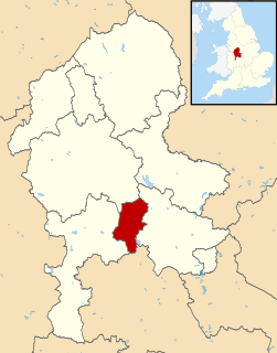
East Staffordshire is a local government district with borough status in Staffordshire in England. It has two main towns: Burton upon Trent and Uttoxeter.

The Heart of England Way is a long-distance walk of around 160 km (100 mi) through the Midlands of England. The walk starts from Milford Common on Cannock Chase and ends at Bourton on the Water in the Cotswolds linking south Staffordshire through Warwickshire to east Gloucestershire.

South Staffordshire is a local government district in Staffordshire, England. The district lies to the north and west of the West Midlands county, bordering Shropshire to the west and Worcestershire to the south. It contains the towns of Penkridge, Brewood and Codsall which are of moderately size, and many settlements within the district are considered dormitory villages for Cannock, Stafford, Telford, and the West Midlands County.
Cannock Chase is a local government district in Staffordshire, England. Its council is based in the town of Cannock; other notable towns are Rugeley, Bridgtown and Hednesford. The district covers a large part of the Cannock Chase Area of Outstanding Natural Beauty, from which it takes its name.

Bromsgrove is a local government district in Worcestershire, England. Its council is based in the town of Bromsgrove.

Penkridge is a market town and civil parish in Staffordshire, England, which since the 17th century has been an industrial and commercial centre for neighbouring villages and the agricultural produce of Cannock Chase.
Staffordshire is a landlocked county in the West Midlands of England. It adjoins Cheshire to the north west, Derbyshire and Leicestershire to the east, Warwickshire to the south east, West Midlands and Worcestershire to the south, and Shropshire to the west. The historic county of Staffordshire includes Wolverhampton, Walsall, and West Bromwich, these three being removed in 1974 to the new county of West Midlands. The resulting administrative area of Staffordshire has a narrow southwards protrusion that runs west of West Midlands to the border of Worcestershire. The city of Stoke-on-Trent was removed in the 1990s to form a unitary authority, but is still considered part of Staffordshire for ceremonial purposes.

The Staffordshire Way is a long-distance walk in Staffordshire, England. The path links with the Cheshire Gritstone Trail, the Heart of England Way and the North Worcestershire Path.
Tamworth was a rural district in the English Midlands from 1894 to 1965.
Staffordshire Fire and Rescue Service is the statutory fire and rescue service responsible for fire protection, prevention, intervention and emergency rescue in the county of Staffordshire and unitary authority of Stoke-on-Trent. The county has a population of 1,126,200 and covers a total area of 2,260 km2. Staffordshire shares the majority of its border with Derbyshire, Cheshire, West Midlands (County) and Shropshire; although, in much shorter stretches, the county also butts up against Worcestershire, Warwickshire and Leicestershire.

Thorpe Constantine is a small village and civil parish in Staffordshire, England. It lies about 6 miles (10 km) north-east of Tamworth and 6 miles south-west of Measham. The nucleus of the parish is the Thorpe estate.

Lichfield District Council is a non metropolitan district council, which covers the district of Lichfield in Staffordshire, England. It was formed in 1974 from Lichfield City Council and Lichfield Rural District Council. The council offices are located at the District Council House on Frog Lane, in the centre of Lichfield.
Penkridge is a market town and parish in Staffordshire with a history stretching back to the Anglo-Saxon period. A religious as well as a commercial centre, it was originally centred on the Collegiate Church of St. Michael and All Angels, a chapel royal and royal peculiar that maintained its independence until the Reformation. Mentioned in Domesday, Penkridge underwent a period of growth from the 13th century, as the Forest Law was loosened, and evolved into a patchwork of manors of greatly varying size and importance, heavily dependent on agriculture. From the 16th century it was increasingly dominated by a single landed gentry family, the Littletons, who ultimately attained the Peerage of the United Kingdom as the Barons Hatherton, and who helped modernise its agriculture and education system. The Industrial Revolution inaugurated a steady improvement in transport and communications that helped shape the modern town. In the second half of the 20th century, Penkridge grew rapidly, evolving into a mainly residential area, while retaining its commercial centre, its links with the countryside and its fine church.
References
- ↑ "The Rural Enterprise Academy". South Staffordshire College. Retrieved 2020-12-04.