Related Research Articles

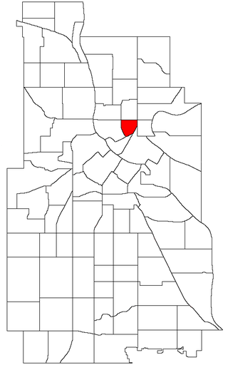
East Isles is a neighborhood within the larger Calhoun-Isles community in Minneapolis, Minnesota, United States. The neighborhood was originally a part of the more historically affluent neighborhoods around Lake of the Isles: Kenwood and Lowry Hill. However, since the 1940s, it has become more urbanized than the rest of the community, since numerous apartment buildings have been built in the area. But, old mansions still can be found hidden in the neighborhood.

The U.S. city of Minneapolis is officially defined by the Minneapolis City Council as divided into eleven communities, each containing multiple official neighborhoods. Informally, there are city areas with colloquial labels. Residents may also group themselves by their city street suffixes, North, Northeast, South, Southeast, and Southwest.

Lowry Hill is a neighborhood within the Calhoun-Isles community in Minneapolis, Minnesota. The neighborhood is regarded as being one of the city’s most upscale and wealthy neighborhoods. It was historically the home of Minneapolis’s most prominent milling and lumber families.

Lowry Hill East, also known as the Wedge, is a neighborhood in southwest Minneapolis, Minnesota, United States, part of the Calhoun Isles community. Lowry Hill East developed in the 1880s along a horse-drawn streetcar line built by Thomas Lowry. The interior of the neighborhood is residential, with large early 20th century homes and multi-unit apartment buildings, while the border streets are lined with bars, restaurants, grocery stores, coffeeshops, and other small businesses. Most housing is renter-occupied.

Calhoun-Isles is one of the official communities in the U.S. city of Minneapolis. It contains the Uptown business district and the name "Uptown" is frequently used to refer to the entire community. The name of the community refers to its most prominent physical features, the large and publicly accessible lakes, Bde Maka Ska and Lake of the Isles.

South Uptown is a residential neighborhood of Minneapolis, Minnesota. In 2018, the neighborhood voted to change its name to South Uptown from its former name CARAG. Other potential names for the neighborhood included "Bryant Park" and "Bryant Square". The Minneapolis City Council approved the name change in November 2018.

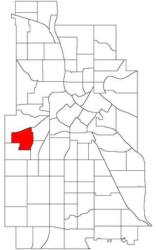
West Maka Ska, formerly known as West Calhoun, is a neighborhood in the U.S. city of Minneapolis. The neighborhood was general rural with a couple grain silos along the railroad track heading into Downtown Minneapolis until about the 1910s. Although the railroad still runs through the neighborhood, the neighborhood is now mainly homes, apartment buildings, and strip malls.
The Windom neighborhood is located in the Southwest community of Minneapolis. Its borders are Diamond Lake Road and West 54th Street to the north, Interstate 35W to the east, West 62nd Street to the south, and Lyndale Avenue South and Highway 121 to the west.
The Southwest community consists of the following neighborhoods: Linden Hills, East Harriet, Kingfield, Fulton, Lynnhurst, Tangletown, Armatage, Kenny, and Windom. This portion of Minneapolis contains many parks and trails along Lake Harriet and Minnehaha Creek.

Hiawatha is a neighborhood within the larger Longfellow community in Minneapolis. It is bordered by Howe to the north, the Mississippi River to the east, Minnehaha Park and Minnehaha neighborhood to the south, and Ericsson and Standish to the west. The Hiawatha neighborhood is bordered by 40th Street to the north, the Mississippi River to the east, 54th Street East to the south, and Hiawatha Avenue to the west.
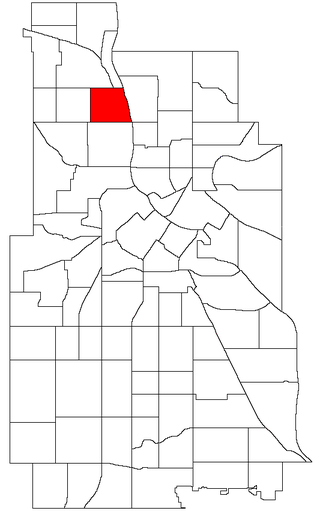
Kenwood is a neighborhood within the Calhoun-Isles community in Minneapolis along Lake of the Isles. The neighborhood is one of the most affluent in the city along with the nearby Lowry Hill neighborhood. The Kenwood neighborhood's most notable feature is the many historic mansions along the parkways overlooking the lake and the downtown skyline.

Bryn Mawr is a neighborhood within the Calhoun-Isles community in Minneapolis located directly west of downtown Minneapolis. Prior to the 1960s, the neighborhood was home to many workers of the nearby Minneapolis and St. Louis Railway yard. The neighborhood is all residential with two small business clusters, and a majority of it is surrounded by parks and hiking trails. The west-northwest border is adjacent to Theodore Wirth Park, while the southwestern perimeter borders Saint Louis Park.


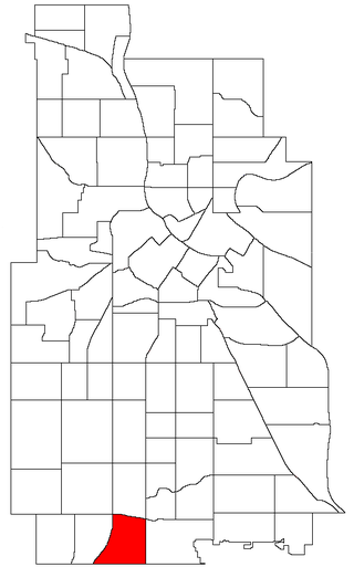
Cedar-Isles-Dean is a neighborhood in the Calhoun-Isles community in Minneapolis. Its boundaries are the Kenilworth Lagoon and Lake of the Isles to the north and east, West Lake Street to the south, and France Avenue South to the west. Nearby neighborhoods include Bryn Mawr and Kenwood to the north, East Isles to the east, East Bde Maka Ska to the southwest, and West Maka Ska to the south. To the west is the suburb of Saint Louis Park. The neighborhood, one of the most affluent in the city, takes its name from Cedar Lake, Lake of the Isles, and Dean Parkway.
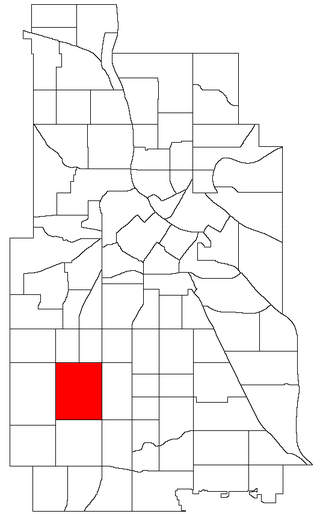
East Harriet is a neighborhood in the Southwest community in Minneapolis. Its boundaries are West 36th Street to the north, Lyndale Avenue South to the east, West 46th Street to the south, and Lake Harriet, Lakewood Cemetery, and William Berry Parkway to the west.

Fulton is a neighborhood in the Southwest community in Minneapolis. Its boundaries are West 47th Street to the north, Penn Avenue South to the east, West 54th Street to the south, and France Avenue South to the west. Nearby neighborhoods include Linden Hills to the north, Lynnhurst to the east, and Armatage to the south. The suburb of Edina lies to the south and west. West 50th Street is a major east–west thoroughfare bisecting the neighborhood. At its intersection with France Avenue is the upscale 50th & France commercial district, which lies along the border between Minneapolis and Edina.

Lyn-Lake is a commercial district in Minneapolis centered at the intersection of West Lake Street and Lyndale Avenue from which it takes its name. The street intersection is the boundary for four official neighborhoods: Whittier on the northeast, Lyndale on the southeast, South Uptown on the southwest, and Lowry Hill East on the northwest. The Lyn-Lake Business Association branded the unofficial commercial district as "Lyn-Lake" in 1999.
McKinley is a neighborhood in the U.S. city of Minneapolis on its northside that is bound to the north by Dowling Avenue North, to the south by Lowry Avenue North, to the west by Dupont Avenue North, and to the east by the Mississippi River. It is part of the larger Camden community. The neighborhood is named for William McKinley, the 25th president of the United States. Many of the homes are two-story, single-family homes with wood frames; bungalows and some small stucco Tudor-style homes. Most of the houses were built between 1910 and 1930. Perkins Hill is the neighborhood park, located between 34th and 35th avenues North near Interstate 94.
St. Anthony East is a neighborhood of the Northeast community in Minneapolis.

The Virginia Triangle is the commons of Hennepin and Lyndale Avenues on Lowry Hill, Minneapolis in the U.S. state of Minnesota.
References
- 1 2 "Minnesota Newspaper Association Director" (PDF). MNA.org. Retrieved January 28, 2020.
- ↑ "About the Southwest Journal". SouthwestJournal.com. Retrieved January 28, 2020.
- ↑ https://m.startribune.com/two-new-publications-target-southwest-minneapolis-a-year-after-its-newspaper-folded/600124739/
44°58′30″N93°16′47″W / 44.975047°N 93.279612°W
| | This article about a Minnesota newspaper is a stub. You can help Wikipedia by expanding it. |