
The Orange Line is a rapid transit line of the Washington Metro system, consisting of 26 stations in Fairfax County and Arlington, Virginia; the District of Columbia; and Prince George's County, Maryland, United States. The Orange Line runs from Vienna in Virginia to New Carrollton in Maryland. Half of the line's stations are shared with the Blue Line and over two thirds are shared with the Silver Line. Orange Line service began on November 20, 1978.

Takoma station is a Washington Metro station on the Red Line in the Takoma neighborhood of Washington, D.C., bordering Takoma Park, Maryland. The station is considered to be located in part of Takoma Park's Historic District. It is the last station in the District of Columbia on the eastern end of the Red Line heading to Maryland, located east of the intersection of Blair Road NW and Cedar Street NW. The station's parking lot and bus stops are accessed from Eastern Avenue NW, which runs along the DC–Maryland line.

Interstate 895 (I-895) is an auxiliary Interstate Highway in the US state of Maryland. Known as the Harbor Tunnel Thruway, the highway runs 11.44 miles (18.41 km) between one junction with I-95 in Elkridge and another interchange with I-95 on the east side of Baltimore. I-895 is a toll road that crosses the Patapsco River estuary via the Baltimore Harbor Tunnel, connecting U.S. Route 1 (US 1), I-695, and the Baltimore–Washington Parkway in the southwestern suburbs of Baltimore with US 40 on the east side of Baltimore. In conjunction with a pair of spurs, unsigned I-895A and I-895B, I-895 provides access to the tunnel from I-97 and Maryland Route 2 (MD 2) in Glen Burnie. The highway is designed for through traffic by having partial interchanges that require vehicles from almost all starting points to pass through the tunnel and the tunnel toll plaza, where a $1.40-$6.00 toll is charged to passenger vehicles, before exiting the facility.

Interstate 395 (I-395) is an auxiliary Interstate Highway in the US state of Maryland. Known as Cal Ripken Way, the highway runs 1.98 miles (3.19 km) from I-95 north to Howard Street and Camden Street in Downtown Baltimore, where it provides access to the Inner Harbor and the Baltimore Convention Center. The Interstate also serves the Camden Yards Sports Complex, which contains M&T Bank Stadium and Oriole Park at Camden Yards, homes of the Baltimore Ravens and Baltimore Orioles, respectively. I-395 also serves as the southern terminus of Martin Luther King Jr. Boulevard, an urban arterial that provides a western bypass of Downtown Baltimore and connects I-95 with U.S. Route 40 (US 40), US 1, and I-83. The Interstate is maintained by the Maryland Transportation Authority (MDTA) and, like all Interstates, is a part of the National Highway System.

The Capital Subdivision is a railroad line owned and operated by CSX Transportation in the U.S. state of Maryland and the District of Columbia. The line runs from near Baltimore, Maryland, southwest to Washington, D.C., along the former Baltimore and Ohio Rail Road (B&O) Washington Branch. The subdivision's Alexandria Extension provides a connection to Virginia and points south.

The Baltimore Light RailLink is a light rail system serving Baltimore, Maryland, United States, and its northern and southern suburbs. It is operated by the Maryland Transit Administration. In downtown Baltimore, it uses city streets. Outside the central portions of the city, the line is built on private rights-of-way, mostly from the defunct Northern Central Railway, Baltimore and Annapolis Railroad and Washington, Baltimore and Annapolis Electric Railway. The system had a ridership of 3,546,300, or about 12,500 per weekday, as of the fourth quarter of 2023.

Howard is an 'L' station in Chicago, Illinois on the North Side Main Line. It is the northern terminus of the Red Line and the southeastern terminus of the Yellow Line; it also serves the Purple Line, for which it is the southern terminus at non-rush hour times on weekdays and all day on weekends. Trains on the Chicago North Shore and Milwaukee Railroad also stopped at Howard from 1926 until that line was abandoned in 1963.
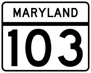
Maryland Route 103 is a state highway in the U.S. state of Maryland. The state highway runs 8.29 miles (13.34 km) from St. Johns Lane in Ellicott City east to Parkway Drive South in Hanover. MD 103 serves as the local complement to MD 100 from Ellicott City in northeastern Howard County through Dorsey to Hanover in northwestern Anne Arundel County. The state highway was constructed from U.S. Route 1 in Elkridge to US 29 in Ellicott City in the 1920s. MD 103's eastern terminus was relocated from Elkridge to US 1 near Dorsey in 1956. When MD 100 was constructed between Glen Burnie and Ellicott City in the 1990s, the state highway was extended to its present western and eastern termini. MD 103 replaced MD 176 from US 1 east to near MD 295.
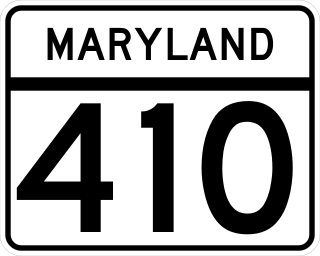
Maryland Route 410 (MD 410) is a state highway in the U.S. state of Maryland and known for most of its length as East–West Highway. The highway runs east to west for 13.92 miles (22.40 km) from MD 355 in Bethesda east to Pennsy Drive in Landover Hills. MD 410 serves as a major east–west commuter route through the inner northern suburbs of Washington, D.C., connecting the commercial districts of Bethesda, Silver Spring, and Hyattsville. In addition, the highway serves the industrial area of Landover Hills and the residential suburbs of Chevy Chase, Takoma Park, Chillum, Riverdale, and East Riverdale. The road also connects many of the arterial highways and freeways that head out of Washington. Additionally, it provides a highway connection to transit and commercial hubs centered around Washington Metro subway stations in Bethesda, Takoma Park, Hyattsville, Silver Spring, and New Carrollton–the latter two of which provide additional connections to MARC and Amtrak trains.

Charles Street, known for most of its route as Maryland Route 139, runs through Baltimore and the Towson area of Baltimore County. On the north end, it terminates at an intersection with Bellona Avenue near Interstate 695 (I-695). At the south end, it terminates in Federal Hill in Baltimore. Charles Street is one of the major routes through Baltimore, and is a major public transportation corridor. For the one-way portions of Charles Street, the street is functionally complemented by the parallel St. Paul Street, including St. Paul Place and Preston Gardens, Maryland Avenue, Cathedral Street, and Liberty Street.

U.S. Route 1 (US 1) is the easternmost and longest of the major north–south routes of the older 1920s era United States Numbered Highway System, running from Key West, Florida, to Fort Kent, Maine. In the U.S. state of Maryland, it runs 81 miles (130 km) from the Washington, D.C. line to the Pennsylvania state line near the town of Rising Sun.

Maryland Route 166 is a state highway in the U.S. state of Maryland. The state highway runs 2.71 miles (4.36 km) from Interstate 195 (I-195) in Arbutus north to MD 144 in Catonsville. MD 166 consists of two sections: a short freeway section that serves as a northern continuation of I-195 and provides access to the University of Maryland, Baltimore County (UMBC), and a segment of Rolling Road, a major north–south highway in western Baltimore County. Rolling Road dates to the colonial era as a highway used to transport tobacco from plantations to river ports. North Rolling Road, which connects Catonsville with Woodlawn and Milford Mill, has always been a county highway. South Rolling Road was constructed as a state highway by the early 1920s between what were to become U.S. Route 1 and US 40. Parts of South Rolling Road were transferred to county maintenance after they were severed by the construction of I-95 and a freeway relocation of the southern end of MD 166 in the early 1970s.

Camden Station, now also referred to as Camden Street Station, Camden Yards, and formally as the Transportation Center at Camden Yards, is a train station at the intersection of South Howard and West Camden Streets in Baltimore, Maryland, adjacent to Oriole Park at Camden Yards, behind the B&O Warehouse. It is served by MARC commuter rail service and local Light Rail trains.

Edgewood station is a passenger rail station on the Northeast Corridor in the unincorporated community of Edgewood, Maryland, served by the MARC Penn Line. Edgewood station serves the southern terminus of Maryland Route 755 which terminates at an entrance to the Aberdeen Proving Ground. The station has two side platforms with a small station building north of the tracks. Parking is located on either side of the station area.

Halethorpe station is a passenger rail station located in the unincorporated community of Halethorpe, Maryland on the Northeast Corridor. MARC Penn Line trains serve the station; Amtrak trains pass through but do not stop.

Muirkirk is a passenger rail station on the MARC Camden Line between the District of Columbia's Washington Union Station and Baltimore's Camden Station. It is located at 7012-B Muirkirk Road over the bridge that carries Muirkirk Road above both the Camden Line and US 1.

Laurel is a historic passenger rail station on the MARC Camden Line in Laurel, Maryland, between the District of Columbia's Washington Union Station and Baltimore's Camden Station.

Dorsey station is a passenger rail station on the MARC Camden Line between Washington, DC and Baltimore's Camden Station in Dorsey, Maryland. The station is located at Exit 7 on Maryland Route 100, a.k.a.; the Paul T. Pitcher Memorial Highway. It was built by MARC in 1996 as a replacement for a former Baltimore and Ohio Railroad station located on Route 103 east of Station House Drive. The former B&O station site is now a condominium development.
Arlington was a station on the abandoned North Shore Branch of the Staten Island Railway, in Staten Island, New York. Located in an open-cut 5.2 miles (8.4 km) from the St. George Terminal, it had two tracks and one island platform. For a few years before its closure in 1953, it was the western terminus of the North Shore Line; before then, the terminus was the Port Ivory station to the west, though most trains terminated at Arlington. It was located in the Arlington and Mariners Harbor sections of Staten Island, near the Arlington Yard, under the South Avenue overpass, between Arlington Place and Brabant Street.

The Baltimore Terminal Subdivision is a railroad line owned and operated by CSX Transportation in the U.S. state of Maryland. The line runs from Baltimore to Halethorpe along the original Baltimore and Ohio Railroad (B&O) line, one of the oldest rail lines in the United States and the first passenger railroad line. At its east (north) end, it connects with the Philadelphia Subdivision; its west (south) end has a junction with the Capital Subdivision and the Old Main Line Subdivision.