St. Mary's County, established in 1637, is a county located in the U.S. state of Maryland. As of the 2020 census, the population was 113,777. Its county seat is Leonardtown. The name is in honor of Mary, the mother of Jesus. St. Mary's County comprises the California-Lexington Park, Maryland Metropolitan Statistical Area, which also is included in the Washington-Baltimore-Arlington, DC-MD-VA-WV-PA Combined Statistical Area. It is part of the Southern Maryland region. The county was the home to the first Maryland Colony, and the first capital of the Colony of Maryland. Settled by English Catholics, it is considered to be the birthplace of religious freedom in North America, at a time when the British colonies were settled primarily by Protestants. The county is home to the Patuxent River Naval Air Station and St. Mary's College of Maryland. Traditionally, St. Mary's County has been known for its unique and historic culture of Chesapeake Bay tidewater farming, fishing, and crabbing communities. But with the advent of the military bases, growth of an extensive defense contractor presence, and the growth of St. Mary's College of Maryland, as well as increasing numbers of long-distance Washington, D.C. commuters, it has been undergoing a decades-long transformation which has seen the county's population double since 1970.

Leonardtown is a town in and the county seat of St. Mary's County, Maryland, United States. The population was 4,563 at the 2020 census. Leonardtown is perhaps most famous for the national oyster-shucking championship that is held annually at the St. Mary's County fairgrounds.

Lexington Park is a census-designated place (CDP) in St. Mary's County, Maryland, United States, and the principal community of the Lexington Park, Maryland Micropolitan Statistical Area. The population was 11,626 at the 2010 census.

The Patuxent River is a tributary of the Chesapeake Bay in the state of Maryland. There are three main river drainages for central Maryland: the Potomac River to the west passing through Washington, D.C., the Patapsco River to the northeast passing through Baltimore, and the Patuxent River between the two. The 908-square-mile (2,352 km2) Patuxent watershed had a rapidly growing population of 590,769 in 2000. It is the largest and longest river entirely within Maryland, and its watershed is the largest completely within the state.

Southern Maryland is a geographical, cultural and historic region in Maryland composed of the state's southernmost counties on the Western Shore of the Chesapeake Bay. According to the state of Maryland, the region includes all of Calvert, Charles, and St. Mary's counties and the southern portions of Anne Arundel and Prince George's counties. It is largely coterminous with the region of Maryland that is part of the Washington metropolitan area.
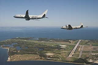
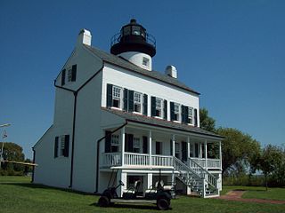
Naval Air Station Patuxent River, also known as NAS Pax River, is a United States naval air station located in St. Mary’s County, Maryland, on the Chesapeake Bay near the mouth of the Patuxent River.

Maryland Route 5 is a 74.34-mile (119.64 km) long state highway that runs north–south in the U.S. state of Maryland. The highway runs from Point Lookout in St. Mary's County north to the Washington, D.C. border in Suitland, Prince George's County. MD 5 begins as two-lane undivided Point Lookout Road which runs from Point Lookout to an intersection with MD 235 in the northern part of St. Mary's County. Point Lookout Road passes through rural areas as well as the county seat of Leonardtown. After the MD 235 intersection, the route becomes four-lane divided Three Notch Road and continues into Charles County, where it becomes Leonardtown Road. Here, the route bypasses Hughesville and continues north toward the Waldorf area, which it bypasses to the east on Mattawoman Beantown Road. The route merges onto U.S. Route 301 and enters Prince George's County, splitting from US 301 at an interchange in Brandywine. From here, MD 5 continues north on Branch Avenue, running through suburban areas, before becoming a freeway as it passes Andrews Air Force Base and has an interchange with Interstate 95 (I-95)/I-495. Past the Capital Beltway, the route runs through suburban areas of Hillcrest Heights and Suitland before reaching the Washington, D.C. border, where Branch Avenue SE continues, crossing Pennsylvania Avenue SE and eventually terminating at Randle Circle.

Leonardtown High School is a comprehensive public high school in Leonardtown, Maryland, United States, for students in grades 9–12. It offers college preparatory programs and programs that prepare students for business and technical occupations. It serves the community in the central portion of St. Mary's County, Maryland, between the Potomac River and Patuxent River. The area is a mixture of rural and suburban communities. Many of the families are employed by NAS Patuxent River, government contractors, St. Mary's College of Maryland, St Mary's County government and others involved in the traditional agriculture and water related businesses.

Great Mills High School is a comprehensive public high school in Great Mills, Maryland, United States. It serves students in grades 9–12 in the mixed rural and suburban area at the confluence of the Potomac River, Patuxent River, and Chesapeake Bay. It belongs to the St. Mary's County Public Schools system, and is associated with two other county high schools: Leonardtown High School and Chopticon High School. The school is accredited by the Middle States Colleges and Secondary Schools and the Maryland State Department of Education.
Chopticon High School is a public high school located in Morganza, Maryland, United States. The school serves students in grades 9–12. It offers college preparatory programs and programs that prepare students for business and technical occupations. It serves the community in the northern portion of St. Mary's County, Maryland, between the Potomac River and Patuxent River. The area is mainly rural communities, with a recent rise in suburban development. Many of the families are employed by NAS Patuxent River, government contractors, St. Mary's College of Maryland, St Mary's County government, and traditional agriculture and water-related businesses.

Anne Arundel County Public Schools is the public school district serving Anne Arundel County, Maryland. With over 80,000 students, the AACPS school system is the 4th largest in Maryland and the 39th largest in the United States. The district has over 5,000 teachers supporting a comprehensive curriculum from Pre-K through 12th grade.
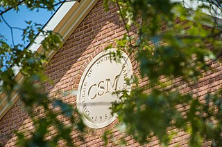
The College of Southern Maryland (CSM) is a public community college with campuses in Hughesville, La Plata, Leonardtown, and Prince Frederick, Maryland. It serves students living in Southern Maryland's Charles, St. Mary's, and Calvert counties.

The Washington, Brandywine & Point Lookout Railroad (WB&PL) was an American railroad that operated in southern Maryland and Washington, D.C., from 1881 to 1954. Its single-track line connected Patuxent River in Maryland to the Pennsylvania Railroad. It operated in and out of bankruptcy and changed its name numerous times.
Baltimore County Public Schools is the school district in charge of all public schools in Baltimore County, Maryland, United States. It is the 25th largest school system in the US as of 2013. The school system is managed by the board of education, headquartered in Towson. The superintendent is Darryl L. Williams, appointed by the School Board on June 11, 2019.
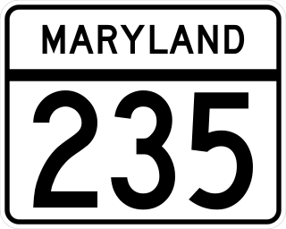
Maryland Route 235 (MD 235) is a state highway in the U.S. state of Maryland. Known as Three Notch Road, the state highway runs 30.63 miles (49.29 km) between its southern intersection with MD 5 in Ridge and its northern intersection with MD 5 near Mechanicsville. While the southern part of the state highway is a two-lane undivided rural road, the northern part of MD 235 is a four- to six-lane divided highway connecting Naval Air Station Patuxent River and the Washington, D.C., metro area in conjunction with MD 5. Three Notch Road has been the main highway between northern St. Mary's County and Point Lookout since the colonial era. The highway was reconstructed as the modern MD 235 between 1923 and 1938. The state highway was then completely rebuilt during World War II to serve the recently established NAS Patuxent River. Between 1960 and 1985, MD 235 was converted into a four-lane divided highway to the west and north of the military base. In the face of increasing activity at the base, the highway adjacent to NAS Patuxent River was expanded to six lanes in the early 2000s.
Great Mills is an unincorporated community in St. Mary's County, Maryland, United States. Great Mills High School serves the lower end of the county, including the town of Lexington Park.
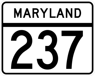
Maryland Route 237 is a state highway in the U.S. state of Maryland. Known as Chancellors Run Road, the route runs 2.95 miles (4.75 km) from MD 246 near Lexington Park north to MD 235 in California. MD 237, which was designated in the mid-1980s, bypasses the center of Lexington Park through the suburban area surrounding Naval Air Station Patuxent River. The state highway was expanded to a four-lane divided highway between 2008 and 2010 in response to increased activity at the military base.

Maryland Route 245 is a state highway in the U.S. state of Maryland. Known for most of its length as Hollywood Road, the state highway runs 7.55 miles (12.15 km) from MD 5 and Washington Street in Leonardtown north to Steer Horn Neck Road near Hollywood. MD 245 connects Leonardtown with MD 235 in Hollywood in central St. Mary's County. The state highway was constructed in the mid-1920s and rebuilt around 1950.

Maryland Route 246 is a state highway in the U.S. state of Maryland. Known for most of its length as Great Mills Road, the state highway runs 3.35 miles (5.39 km) from MD 5 in Great Mills east to the entrance to Naval Air Station Patuxent River just east of the highway's intersection with MD 235 in Lexington Park. In conjunction with MD 5, MD 246 connects NAS Patuxent River and the suburban area surrounding the military base with Leonardtown. The state highway was originally constructed around 1920. MD 246 extended east onto land now occupied by NAS Patuxent River to serve a ferry from St. Mary's County to the southern end of Calvert County. The ferry was discontinued and the state highway's eastern terminus was rolled back to MD 235 when NAS Patuxent River was constructed during World War II; the remainder of MD 246 was upgraded as a military access project. MD 246 was expanded to a multi-lane highway in the 1990s.
