St Albans, New Zealand

Last updated

St Albans
St-Albans-library.jpg
The old St Albans library, since demolished following earthquake damage
St Albans, New Zealand
Coordinates: 43°30′29″S172°37′48″E / 43.508°S 172.630°E / -43.508; 172.630
CountryNew Zealand
City Christchurch
Local authority Christchurch City Council
Electoral ward
  • Fendalton
  • Papanui
  • Innes
Community board
  • Waimāero Fendalton-Waimairi-Harewood
  • Waipapa Papanui-Innes-Central
Area
[1]
  Land397 ha (981 acres)
Population
 (June 2023) [2]
  Total13,830
Postcode(s)
8014
Papanui Northcote Mairehau
Strowan
Merivale
Pfeil oben.svg
Pfeil links.svgSt AlbansPfeil rechts.svg
Pfeil unten.svg
Edgeware
Christchurch Central City

St Albans is a large, inner-northern suburb of Christchurch, New Zealand, located directly north of the Christchurch Central Business District. It is the second largest suburb in the city by population (behind Halswell), with a population of 13,137 at the 2018 Census. The suburb falls within the Christchurch Central electorate and is represented by Duncan Webb, who has been the member of parliament since the 2017 general election. St Albans is one of the most diverse residential neighbourhoods in Christchurch, with a wide range of densities, architectural styles and housing ages throughout the suburb. It has everything from run-down high-density council-owned flats, to modern luxurious high-density flats and apartments; old mid-density workers cottages through to large low-density estates of various ages.

Contents

History

Originally a working-class settlement, St Albans was a separate borough from 1881 until 1903 when it became part of Christchurch City. St Albans was named after George Dickinson's farm, which lay to the south of the St Albans Creek. He had called his farm St Albans in memory of his cousin Harriet Mellon, an actress, who had become the Duchess of St Albans. [3]

Earthquake damage

The suburb escaped severe damage in the 2010 Canterbury earthquake. Many chimneys came down but only a few complete houses were affected. In the 22 February 2011 earthquake, however, the suburb was hit hard. Many houses, supermarkets, and shops were significantly damaged with a lot ending up totally demolished. In July 2011, the demolition of the former library, which houses the community centre, was ordered by the Canterbury Earthquake Recovery Authority. [4] By 2014 the extent of the damage to drainage systems and lowered ground levels had become apparent, with the regular flooding of a series of streets known as the Flockton Basin. [5]

Boundaries

The suburb of St Albans is bordered by:

These correspond roughly to the NZ Localities area maintained by Fire and Emergency NZ. [6]

Inconsistencies

The borders of St Albans are often disputed, particularly by real estate agents who often list higher-priced properties that lie within western St Albans as belonging to Merivale instead. The original borough of St Albans stretched to include most of modern-day Edgeware, Mairehau and Merivale as well as the current St Albans suburb. There is a sign off of Bealey Avenue which points to St Albans down Barbadoes Street which is actually in the middle of the suburb of Edgeware instead of St Albans.

In 2013, geography students at the University of Canterbury conducted a survey asking St Albans residence where they thought the boundaries lay. The findings differed from Christchurch City Council boundaries and New Zealand Post boundaries, in that residents perceived the boundary to be Innes Road to the north, Hills Road to the east, Bealey Avenue to the south and Papanui Road to the west. [7]

Demographics

St Albans covers 3.97 km2 (1.53 sq mi). [1] It had an estimated population of 13,830 as of June 2023, with a population density of 3,484 people per km2.

Historical population
YearPop.±% p.a.
200612,987    
201312,768−0.24%
201813,137+0.57%
202313,830+1.03%
Source: [8]

St Albans had a population of 13,137 at the 2018 New Zealand census, an increase of 369 people (2.9%) since the 2013 census, and an increase of 150 people (1.2%) since the 2006 census. There were 5,448 households, comprising 6,498 males and 6,633 females, giving a sex ratio of 0.98 males per female, with 2,043 people (15.6%) aged under 15 years, 3,231 (24.6%) aged 15 to 29, 6,087 (46.3%) aged 30 to 64, and 1,773 (13.5%) aged 65 or older.

Ethnicities were 82.9% European/Pākehā, 7.0% Māori, 2.0% Pasifika, 12.8% Asian, and 2.9% other ethnicities. People may identify with more than one ethnicity.

The percentage of people born overseas was 28.0, compared with 27.1% nationally.

Although some people chose not to answer the census's question about religious affiliation, 50.6% had no religion, 36.7% were Christian, 0.2% had Māori religious beliefs, 2.2% were Hindu, 0.8% were Muslim, 1.2% were Buddhist and 3.6% had other religions.

Of those at least 15 years old, 3,894 (35.1%) people had a bachelor's or higher degree, and 1,098 (9.9%) people had no formal qualifications. 2,622 people (23.6%) earned over $70,000 compared to 17.2% nationally. The employment status of those at least 15 was that 6,387 (57.6%) people were employed full-time, 1,638 (14.8%) were part-time, and 324 (2.9%) were unemployed. [8]

Individual statistical areas
NameArea
(km2)
PopulationDensity
(per km2)
HouseholdsMedian ageMedian
income
Malvern0.992,6042,63091834.6 years$44,500 [9]
Rutland0.992,9042,9331,07143.8 years$43,100 [10]
St Albans North0.642,1363,33896637.1 years$37,000 [11]
St Albans West0.682,5233,7101,18237.5 years$39,500 [12]
St Albans East0.682,9704,3681,31132.8 years$39,700 [13]
New Zealand37.4 years$31,800

Community facilities

St Albans Park St Albans Park, Christchurch, New Zealand.jpg
St Albans Park

The hub of St Albans is Edgeware Village on Edgeware Road which contains a small number of well-supported shops. The three main parks in the suburb are St Albans Park, [14] Abberley Park, and Malvern Park. [15] Sports facilities include Canterbury United Football Club's stadium, English Park, and Rugby Park, the home of the Crusaders professional rugby union team.

Education

The suburb contains two primary schools, St Albans Primary School [16] and St Albans Catholic School, [17] which both provide education for years 1 to 6. [18] [19] As of February 2024, they have rolls of 516 and 102 students, respectively. [20] St Albans School opened in 1873 [21] and St Albans Catholic School opened in 1955. [22]

St Albans News

St Albans is known for its sense of cohesiveness and community spirit. This has manifested itself in the local monthly paper, the St Albans Neighbourhood News, [23] which was first published by a group of local residents in 1993 and is still going to this day under the name of St Albans News. Distributed to 5,000 homes and businesses, the paper has recently been expanded to fill 16 pages. Over the years it has been central in numerous community-related issues including local planning, Packe Street Park, the Edgeware Road Tragedy, and the closure of Edgeware swimming pool (to which it was editorially opposed). After the community regained control of the pool site, it was announced that the pool would be rebuilt with a generous donation from a local resident. [24]

Notable residents

Related Research Articles

<span class="mw-page-title-main">Hurlstone Park</span> Suburb of Sydney, New South Wales, Australia

Hurlstone Park is a suburb in the Inner West of Sydney, New South Wales, Australia. Hurlstone Park is located nine kilometres south-west of the Sydney central business district and is mostly in the local government area of the City of Canterbury-Bankstown, and partly in the Inner West Council. The suburb is bounded by: the Cooks River to the south, Garnet Street to the east, New Canterbury Road to the north, Canterbury Road to the north-west, and Church Street to the west.

<span class="mw-page-title-main">Papanui</span> Suburb of Christchurch, New Zealand

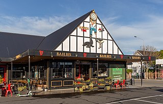
Papanui is a major suburb of Christchurch, New Zealand. It is situated five kilometres to the northwest of the city centre. Papanui is a middle socio-economic area with a population of 3,645 consisting predominantly of Pākehā 86.9%, Asian 7.6%, Māori 5.3%, Pacific peoples 3.1%, Middle Eastern/Latin American/African 0.7%. The suburb is located at the junction of three busy thoroughfares; Papanui Road leading to the city, the Main North Road that leads to North Canterbury and Harewood Road that leads to Christchurch International Airport. However, as with most Christchurch suburbs, Papanui has no defined borders.

<span class="mw-page-title-main">Riccarton, New Zealand</span> Suburb of Christchurch, New Zealand

Riccarton is a suburb of Christchurch. It is due west of the city centre, separated from it by Hagley Park. Upper Riccarton is to the west of Riccarton.

<span class="mw-page-title-main">Addington, New Zealand</span> Suburb of Christchurch, New Zealand

Addington is a major suburb of Christchurch, New Zealand. It is sited 2.5 kilometres (1.6 mi) south-west of the city centre.

<span class="mw-page-title-main">Shirley, New Zealand</span> Suburb of Christchurch, New Zealand

Shirley, sometimes referred to as Windsor, is a suburb of Christchurch, New Zealand, about 5 kilometres (3.1 mi) north-east of the city centre. The area was used for farming from the 1850s, and subdivision started in the early 20th century, with most of the houses being built between 1950 and 1980.

<span class="mw-page-title-main">Bryndwr</span> Suburb of Christchurch, New Zealand

Bryndwr is a suburb in the north-west of Christchurch, New Zealand.

<span class="mw-page-title-main">Redwood, Christchurch</span> Suburb of Christchurch, New Zealand

Redwood is a northern suburb of Christchurch, New Zealand which includes the sub-division of Redwood Springs. It is bordered by the Styx River to the north.

<span class="mw-page-title-main">Bishopdale, Christchurch</span> Suburb of Christchurch, New Zealand

Bishopdale is a residential suburb located in the north of Christchurch, New Zealand.

<span class="mw-page-title-main">Merivale, Christchurch</span> Suburb of Christchurch, New Zealand

Merivale is a suburb of Christchurch, New Zealand, north of the city centre. Like all suburbs in Christchurch, it has no defined boundaries and is a general area, but for the purposes of statistical analysis only, Statistics New Zealand defines it as being Heaton Street to the north, Papanui Road to the east, Harper and Bealey Avenues to the south and Rossall Street to the west, although Real Estate advertising often will claim residences outside this area, especially St Albans to the east of Papanui Road, as being Merivale due to the perceived desirability of the area. The area directly west of Rossall Street, which is called Holmwood by Statistics New Zealand, is sometimes considered part of Merivale.

<span class="mw-page-title-main">Beckenham, New Zealand</span> Suburb of Christchurch, New Zealand

Beckenham is an inner suburb of Christchurch, New Zealand, located three kilometres south of the city centre. The Ōpāwaho / Heathcote River winds through this predominantly residential suburb, a section of which is often referred to locally as the "Beckenham Loop". Beckenham is bounded by Sydenham to the north, Somerfield to the west, Cashmere and Huntsbury to the south and St Martins to the east.

<span class="mw-page-title-main">Strowan</span> Suburb of Christchurch, New Zealand

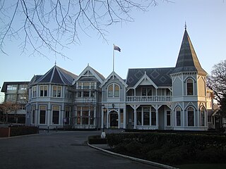
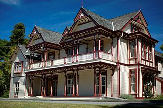
Strowan is an affluent suburb of Christchurch, New Zealand, located approximately 5 km north-west of Christchurch's central business district. It had a population of 3,705 at the 2013 census. It is located between the suburbs of Merivale, Papanui, Bryndwr, Fendalton, and St Albans.

<span class="mw-page-title-main">Edgeware</span> Suburb of Christchurch, New Zealand

Edgeware is a suburb of Christchurch, New Zealand, to the north of the central city. It is centred on a cluster of some 20 shops that make up Edgeware Village on Edgeware Road near Colombo Street's northern end. The boundaries of the suburb are debated. Google maps includes St Albans park as being within the boundaries of Edgeware, while excluding the Edgeware shops at the western end of Edgeware Road.

<span class="mw-page-title-main">Christchurch Central City</span> Central area of Christchurch, New Zealand

Christchurch Central City or Christchurch City Centre is the geographical centre and the heart of Christchurch, New Zealand. It is defined as the area within the Four Avenues and thus includes the densely built up central city, some less dense surrounding areas of residential, educational and industrial usage, and green space including Hagley Park, the Christchurch Botanic Gardens and the Barbadoes Street Cemetery.

<span class="mw-page-title-main">Henry Richard Webb</span> New Zealand businessman and politician

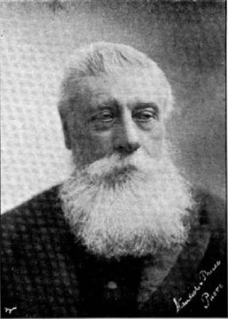
Henry Richard Webb JP FRMS was a New Zealand businessman and politician. He represented Lyttelton in Parliament for 2½ years and was a supporter of education in his later years. Born in Australia, he came to Canterbury in 1868.

Christchurch tramway routes have developed from lines that were first established by a troika of private tramway companies in the latter part of the 19th century, through to a significantly expanded system under the municipal Christchurch Tramway Board, to the City Council-built heritage circuit. These routes have been worked by all three main forms of tramway motive power and have significantly contributed to the development of Christchurch City in New Zealand's South Island.

<span class="mw-page-title-main">Colombo Street</span> Main road in Christchurch, New Zealand

Colombo Street is a main road of the city of Christchurch, New Zealand. It runs south-north through the centre of Christchurch with a break at Cathedral Square. As with many other central Christchurch streets, it is named for a colonial Anglican bishopric, Colombo, Sri Lanka in what at the time was known as Ceylon. Parts of the street which run through Sydenham were known as Addison Street during the 1880s, and some parts were known as Colombo Road.

<span class="mw-page-title-main">Carlton Hotel, Christchurch</span> Hotel in Christchurch, New Zealand

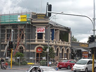
The Carlton Hotel in Christchurch was an historic pub on the corner of Papanui Road and Bealey Avenue. Built in 1906 for the New Zealand International Exhibition, it was registered by the New Zealand Historic Places Trust as a Category II heritage building. The building was damaged in the February 2011 Christchurch earthquake and demolished on 9 April 2011.

<span class="mw-page-title-main">Samuel Farr (architect)</span>

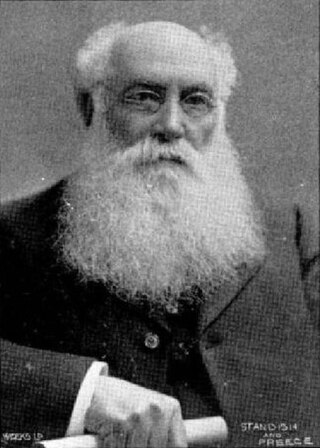
Samuel Charles Farr was a 19th-century builder and architect in Christchurch, New Zealand. He intended to emigrate from England to Auckland, but significant shipping problems saw him end up in Akaroa in 1850 instead. From 1862, he lived in Christchurch. Farr has a number of firsts against his name: the first marriage in Canterbury, he designed Akaroa's first church, designed New Zealand's first iron verandahs, and he started Sunday schools in Canterbury. As a leading member of the Acclimatisation Society, he stocked almost every lake and river in Canterbury with fish and was instrumental in introducing the bumblebee to New Zealand. His most notable building was Cranmer Court, the former Normal School, in the Christchurch Central City; this building was demolished following the February 2011 Christchurch earthquake.

Robert William England was a New Zealand architect from Christchurch.

<span class="mw-page-title-main">The Four Avenues</span>

The Four Avenues are a group of four major arterial boulevards — Bealey Avenue, Fitzgerald Avenue, Moorhouse Avenue, and either Rolleston Ave or Deans Avenue — that surround the city centre of Christchurch, New Zealand. Serving as an inner ring road, they popularly form the limits of the city centre, separating it from the city's suburbs. Almost all of the city's commercial heart lies within the approximately rectangular 9.8-square-kilometre (3.8 sq mi) area formed by the four avenues. The term "within the Four Avenues" is widely used in Christchurch to refer to the central city. By extension, Christchurch as a whole is sometimes referred to as "The Four Avenues".

References

  1. 1 2 "ArcGIS Web Application". statsnz.maps.arcgis.com. Retrieved 20 September 2021.
  2. "Population estimate tables - NZ.Stat". Statistics New Zealand . Retrieved 25 October 2023.
  3. St Albans, from Swamp to Suburbs, An Informal History. New Zealand federation of University Women Canterbury Branch. 1989. pp. 13–14. ISBN   0-473-00693-6.
  4. "Deconstruction of damaged Council-owned community facility". Christchurch City Council . Retrieved 23 July 2011.
  5. Cairns, Lois (6 March 2014). "Flockton flood protection two years away". The Press . Retrieved 1 December 2015.
  6. "NZ Suburbs and Localities". Toitū Te Whenua - Land Information New Zealand. Retrieved 18 September 2023.
  7. Amuri Hughey-Cockerell, Annabelle Simpson Alice Knight, Andrew Douglas-Clifford (2013). "Developing a Sense of Place in St Albans" (PDF). University of Canterbury . Retrieved 27 April 2024.{{cite web}}: CS1 maint: multiple names: authors list (link)
  8. 1 2 "Statistical area 1 dataset for 2018 Census". Statistics New Zealand. March 2020. Malvern (322100), Rutland (322200), St Albans North (323800), St Albans West (323900) and St Albans East (324800).
  9. 2018 Census place summary: Malvern
  10. 2018 Census place summary: Rutland
  11. 2018 Census place summary: St Albans North
  12. 2018 Census place summary: St Albans West
  13. 2018 Census place summary: St Albans East
  14. "A to Z of Christchurch Parks – St Albans Park". .ccc.govt.nz. Retrieved 16 February 2014.
  15. "A to Z of Christchurch Parks – Malvern Park". .ccc.govt.nz. Retrieved 16 February 2014.
  16. "St Albans School | Welcome to our website". St Albans School. 4 July 2013. Retrieved 16 February 2014.
  17. "St Albans Catholic School (Christchurch) .::. Welcome". St Albans Catholic School. Retrieved 16 February 2014.
  18. Education Counts: St Albans School
  19. Education Counts: St Albans Catholic School
  20. "New Zealand Schools Directory". New Zealand Ministry of Education. Retrieved 14 March 2024.
  21. Centennial, 1873–1973 St Albans School. Christchurch City Libraries. 1973. Retrieved 20 September 2021.
  22. "School History". St Albans Catholic School. Retrieved 20 September 2021.
  23. "The St Albans Community Website" . Retrieved 18 September 2023.
  24. Conway, Glenn (26 March 2010). "Edgeware community wins pool fight". The Press . Retrieved 13 November 2011.
  25. Maling, Peter B. "Acland, Hugh Thomas Dyke". Dictionary of New Zealand Biography . Ministry for Culture and Heritage . Retrieved 7 January 2012.
  26. "Chippenham Lodge". New Zealand Heritage List/Rārangi Kōrero. Heritage New Zealand . Retrieved 16 February 2014.