Wigram

Last updated

Wigram
WigramAirfieldChristchurch.jpg
The former Wigram Aerodrome, which has since been converted into the Wigram Skies development
Wigram
Location of Wigram in Christchurch.
Coordinates: 43°33′12″S172°33′30″E / 43.5533°S 172.5584°E / -43.5533; 172.5584
CountryNew Zealand
City Christchurch
Local authority Christchurch City Council
Electoral wardHalswell [1]
Established1923
Area
[2]
  Land490 ha (1,210 acres)
Population
 (June 2022) [3]
  Total11,140
Airport(s) Wigram Aerodrome (former)
Hei Hei Sockburn Upper Riccarton
Hornby
Pfeil oben.svg
Pfeil links.svgWigramPfeil rechts.svg
Pfeil unten.svg
Middleton
Halswell Aidanfield Hillmorton

Wigram is a suburb in the southwest of Christchurch, New Zealand. The suburb lies close to the industrial estates of Sockburn and the satellite retail and residential zone of Hornby, and has undergone significant growth in recent years due to housing developments. It is seven kilometres to the west of the city centre.

Contents

Etymology

The suburb is named after Sir Henry Wigram, mayor of Christchurch from 1902 to 1903, [4] who established a flying school there in 1916. [5] Wigram kept the aviation school going until March 1923, when the government decided to take over the company and run the airbase under a military umbrella. The final purchase price was £31,012.

In June 1923 the base was officially handed over and renamed Wigram Aerodrome. Wigram continued to support the base, gifting a further 81 acres (33 ha) of land in 1932. [6]

History

The first trans-Tasman flight touched down in Wigram on 11 September 1928 at 9.22 a.m. Piloted by Australian's Charles Kingsford Smith and Charles Ulm they departed Richmond, west of Sydney flying the Southern Cross . [7] The welcome was tremendous. A crowd of 30,000 people, one quarter of the total population of Christchurch at that time, turned out to see this historic event. A plaque on the landing site at Wigram Skies commemorates the event. The Heritage Reserve, located on Bennington Way in the George West neighbourhood, marks the actual location of the touchdown by the Southern Cross. The commemorative plaque placed nearby was originally used in 1978 to mark the 50th Anniversary of this landing. [8]

The worst RNZAF crash in New Zealand history occurred at Wigram on 15 October 1953, killing seven men. Two Royal New Zealand Air Force De Havilland Devons, the NZ1811 and NZ1810 from RNZAF Station Wigram, collided over Wigram Aerodrome. They had been part of the last section of a 27 aircraft flypast over Harewood International Airport (as Christchurch airport was then called) marking the 1953 London to Christchurch Air Race Prize Giving Ceremony. When the formation broke up as the aircraft prepared to land back at Wigram, NZ1811 was struck on the wing by its “No. 2”, NZ1810. [9] Sixty-five years after the fatal air collision, a plaque, inset into a boulder and featuring the names of the flight crew has been placed next to a memorial seat in a reserve at the end of Edwin Ebbett Place. All seven crew members are remembered by street names in the area such as Erling Ziesler Lane. [10]

Wigram was home to RNZAF Wigram, one of the main bases of the Royal New Zealand Air Force, but this was closed in 1995 after cutbacks in military spending. [11] The majority of Wigram Aerodrome was purchased by Ngāi Tahu in 1997, and continued to be used as a private airfield until it was finally closed on 1 March 2009. [12] The RNZAF retained the original portion of the aerodrome which had been purchased by the Crown for the purpose of an Air Force base in 1923, an area which includes the Air Force Museum of New Zealand.

The 21st century has seen several subdivision developments being undertaken in Wigram.

Wigram Skies

The remainder of the former airfield was subdivided by Ngāi Tahu Property into the Wigram Skies development following its closure. Street names in the new development reflect the area's aviation heritage, with names such as Corsair Drive, Kittyhawk Avenue and Skyhawk Road alongside The Runway – a road which follows the route of the former runway. [13]

Broken Run (East)

In 2005, this subdivision created six new roads and two new formed and sealed rights of way to provide access to 126 new residential allotments, and six new reserves totalling 2.8 hectares.

The subdivision has been named “Broken Run” by Brian Gillman Limited, as the land before development was a grazing farm with a natural valley and waterway splitting the farm into two halves, thus being a broken farm or run. The property is located at the headwaters of the Heathcote River. [14]

The road names in Broken Run share a common theme of high country stations, e.g. Longspur Avenue (Longspur is a high country station near the Rakaia Gorge) [15] and Highpeak Place (Highpeak Station is located at the head of the Selwyn River). [16]

Broken Run (West)

Surplus land from Christchurch's Southern Motorway extension was purchased in 2013 and subsequently developed by Gillman Wheelans in 2015. The Western part of Broken Run backs onto the original Broken Run subdivision [17] separated by the Heathcote River. The subdivision created sixty-one residential allotments, two allotments to vest in the Council as reserve, and a further four allotments vested as legal road. [18]

The road names for this stage continued the theme from the original Broken Run subdivision of high country farms e.g. Four Peaks Drive (Four Peaks Station, near Fairlie in South Canterbury). [19]

Geography

Wigram is north of Aidanfield, separated by the Christchurch Southern Motorway. Wigram also borders several other suburbs:

Middleton to the east, separated by Curletts Road.

Hornby to the west and northwest separated by Awatea Road (properties on Awatea road are not part of Wigram except a small number of properties on the east side of Awatea Road (numbers 65–135 inclusive), [20] Springs Road and Main South Road (properties located on these roads are not part of Wigram) [20]

Sockburn to the north separated by the Main South Line Railway

Hillmorton to the southeast separated by Curletts Road and the Heathcote River (Ōpāwaho)

Demographics

The recent development of the Wigram Aerodrome into housing has resulted in the suburb growing significantly in recent years. This has made Wigram one of the fastest-growing suburbs in post-earthquake Christchurch. [21]

Wigram covers 4.90 km2 (1.89 sq mi). [2] It had an estimated population of 11,140 as of June 2022, with a population density of 2,273 people per km2.

Historical population
YearPop.±% p.a.
20062,076    
20133,276+6.73%
20188,226+20.22%
Source: [22]

Wigram had a population of 8,226 at the 2018 New Zealand census, an increase of 4,950 people (151.1%) since the 2013 census, and an increase of 6,150 people (296.2%) since the 2006 census. There were 2,706 households. There were 4,092 males and 4,140 females, giving a sex ratio of 0.99 males per female, with 1,368 people (16.6%) aged under 15 years, 2,001 (24.3%) aged 15 to 29, 3,822 (46.5%) aged 30 to 64, and 1,035 (12.6%) aged 65 or older.

Ethnicities were 49.8% European/Pākehā, 5.7% Māori, 1.7% Pacific peoples, 45.8% Asian, and 2.9% other ethnicities (totals add to more than 100% since people could identify with multiple ethnicities).

The proportion of people born overseas was 46.7%, compared with 27.1% nationally.

Although some people objected to giving their religion, 49.4% had no religion, 37.2% were Christian, 2.5% were Hindu, 2.0% were Muslim, 2.3% were Buddhist and 2.3% had other religions.

Of those at least 15 years old, 2,127 (31.0%) people had a bachelor or higher degree, and 924 (13.5%) people had no formal qualifications. The employment status of those at least 15 was that 3,699 (53.9%) people were employed full-time, 879 (12.8%) were part-time, and 222 (3.2%) were unemployed. [22]

Individual statistical areas
NamePopulationHouseholdsMedian ageMedian income
Wigram North63327936.4 years$28,900 [23]
Wigram West1,40145934.4 years$35,100 [24]
Wigram South1,32042031.1 years$37,000 [25]
Wigram East77724931.2 years$38,600 [26]
Awatea North2,47876536.5 years$35,100 [27]
Awatea South1,04135135.9 years$32,300 [28]
Broken Run57618335.2 years$42,100 [29]
New Zealand37.4 years$31,800

Wigram is one of Christchurch's more affluent suburbs with residents earning, on average, over 10% more than the average Christchurch resident. [30]

Over 45% of people living in Wigram identify as Asian whilst almost 50% identify as European. Wigram has a significantly lower percentage of people identifying as Maori or Pacific Islanders compared to Christchurch City as a whole.

People living in Wigram compared to Christchurch City are 10% more likely to be managers and 16% more likely to be professionals. They are also 32% less likely to be machinery operators and drivers and 27% less likely to be labourers.

Economy

Commercial

The Landing, located at the heart of Wigram Skies, provides a convenient and modern retail and mixed use space for Wigram Skies residents and greater south west Christchurch. [31] Stage one of The Landing, which was completed in mid-2015, has a 8975 sqm site area, including 2000 sqm of retail and office space spread across three buildings and a 2600 sqm New World supermarket. [32]

Stage Two, which was completed in 2017 boasts a 3509sq m site area, including 1800sq m of retail, 600sq m of office space, and 451sq m of hospitality spread across three buildings. [33]

The latest development, a new Cimena Complex with eight cinema screens, each seating 48 people, is set to Open in July 2021 [34]

Industrial

One of the hotspots in the Christchurch scene is Wigram Business Park, developed by Ngāi Tahu, with most of the properties sold to owner occupiers. [35] It is located on Hayton Road on approximately 25 hectares of zoned Business 4 and has 52 lots. [36] It adjoins Hayton Stream and multiple reserves which separate it from Wigram Skies.

The park is now home to a prestigious collection of occupiers and is very popular among businesses wanting to occupy modern, state-of-the-art premises on quality land to the west of Christchurch. [37]

Wigram Business Park provides for businesses in Christchurch who were expanding but also offered a safe alternative for operators who were looking at relocating or re-establishing their businesses after earthquakes. [36] One example is the purchase by NZX 50 listed Skellerup of a 3.4-hectare site in 2013 for $7.1 million which was subsequently developed into a $30 million, 18,900-square-metre purpose built manufacturing and office facilities to replace their quake-damaged Woolston site. [38]

Another NZX 50 company to have modern premises in Wigram is Mainfreight with the development of their Hayton Road Logistics site completed in May 2015. [39]

Transport

Road

Wigram is well-connected for road transport, with direct access via Parkhouse Road/Curletts Road to the State Highway Motorway network:

Three Super-T bridges connect Wigram via local link roads with its neighbouring suburbs:

Public transport

Wigram is also well served by several bus services, known as Metro [42] which is subsidised by Environment Canterbury. [43]

The following routes pass directly through or on the border of Wigram:

Landmarks and features

National institutions

The Air Force Museum of New Zealand, formerly called The Royal New Zealand Air Force Museum, is the national museum for the Royal New Zealand Air Force (RNZAF) and New Zealand military aviation, and stands on the site of the former air base. [45] Also located on the Crown-owned, New Zealand Defence Force site [46] is the Archives New Zealand Repository on Harvard Ave which was officially opened on 9 October 2018. [47]

Parks, sports and recreation

Wigram has two large recreational parks adjoining each other, Ngā Puna Wai was opened on 8 March 2019 [48] and comprises 32 hectares (79 acres) of recreation, esplanade reserve and other park land as well as a new $53.65 million multi-sports facility [49] whilst future plans include a new $20 million indoor sports centre. [50] Canterbury Agricultural Park is a large open space of around 130 hectares (320 acres), [51] and is famous for the Canterbury A&P Show [52]

There are also several smaller local neighbourhood parks, the largest of these is Te Kāhu Park bound by The Runway, Curtis Street, Dalwood Drive and Porter Street, boasting a children’s playground, three sports pitches within walking distance of all residences [53] and is the home ground for the Halswell Wigram Rugby Club. [54]

Other parks include:

Elderly housing and care

Wigram has two modern retirement villages, the first to open was Lady Wigram Village [58] which opened in 2015 and is located on Kittyhawk Avenue. [59] Opening soon after in 2016 [60] was Summerset at Wigram [61] located on Awatea Road on the South West edge of Wigram.

Education

Governance

Member of Parliament for Wigram, Dr Megan Woods Hon Dr Megan Woods.jpg
Member of Parliament for Wigram, Dr Megan Woods

Community board

Wigram is represented in the Waipuna/Halswell-Hornby-Riccarton Community Board [66] by two Halswell Ward Community Board members, Andrei Moore and Debbie Mora. [67]

Council ward

Wigram is part of the Halswell Ward [66] represented by Councillor Anne Galloway since 2016. [68]

National electorate

The Suburb of Wigram sits in the aptly named New Zealand parliamentary electorate of Wigram. [69]

The local MP representing the Wigram Electorate since 2011 is Dr Megan Woods. [70]

Related Research Articles

<span class="mw-page-title-main">Royal New Zealand Air Force</span> Air force component of the New Zealand Defence Force

The Royal New Zealand Air Force is the aerial service branch of the New Zealand Defence Force. It was formed from New Zealand elements of the British Royal Air Force, becoming an independent force in 1923, although many RNZAF aircrew continued to serve in the Royal Air Force until the end of the 1940s.

<span class="mw-page-title-main">Christchurch</span> City in the South Island of New Zealand

Christchurch is the largest city in the South Island of New Zealand and the seat of the Canterbury Region. Christchurch lies on the South Island's east coast, just north of Banks Peninsula on Pegasus Bay. The Avon River / Ōtākaro flows through the centre of the city, with an urban park along its banks. The city's territorial authority population is 389,300 people, and includes a number of smaller urban areas as well as rural areas. The population of the urban area is 377,900 people. Christchurch is the second-largest city by urban area population in New Zealand, after Auckland. It is the major urban area of an emerging sub-region known as Greater Christchurch. Notable smaller urban areas within this sub-region include Rangiora and Kaiapoi in Waimakariri District, north of the Waimakariri River, and Rolleston and Lincoln in Selwyn District to the south.

<span class="mw-page-title-main">Christchurch Airport</span> Airport in Christchurch, New Zealand

Christchurch Airport is the main airport that serves Christchurch, New Zealand. It is located 12 kilometres (7.5 mi) to the northwest of the city centre, in the suburb of Harewood. Christchurch (Harewood) Airport officially opened on 18 May 1940 and became New Zealand's first international airport on 16 December 1950. It is the third busiest airport in New Zealand, after Auckland and Wellington by annual passengers, and the second busiest, after Auckland, by aircraft movements.

<span class="mw-page-title-main">Ōpāwaho / Heathcote River</span> River in Christchurch, New Zealand

The Ōpāwaho / Heathcote River lies within the city boundaries of Christchurch, New Zealand, and is fed from springs near Templeton Road, with a catchment area in wet weather extending as far west as Yaldhurst and Pound Road. It meanders around the base of the Port Hills from west to south-east.

<span class="mw-page-title-main">Halswell</span> Suburb in Christchurch, New Zealand

Originally a separate village, Halswell is now a residential suburb of Christchurch, New Zealand, located 9 kilometres (5.6 mi) southwest of Cathedral Square on State Highway 75.

<span class="mw-page-title-main">Hornby, New Zealand</span> Suburb in Christchurch, New Zealand

Hornby is a major residential and retail suburb at the western edge of Christchurch, New Zealand. The suburb is directly connected to other parts of Christchurch and the South Island by a number of main arterial routes, including State Highway 1 and the Christchurch Southern Motorway.

<span class="mw-page-title-main">Wigram Aerodrome</span> Closed Airport in Christchurch, NZ

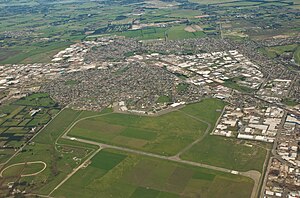
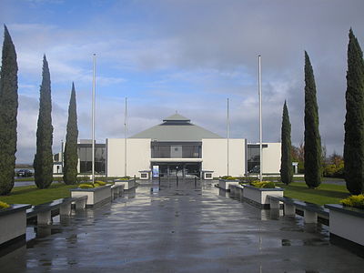
Wigram Aerodrome is located in the Christchurch suburb of Sockburn, later to be split-suburb of Wigram and now split again as Wigram Skies. It was gifted by Sir Henry Wigram for the Canterbury (NZ) Aviation Company on 20 September 1916 and originally named Sockburn Airport. In 1923 that was then gifted to the Crown as a Royal New Zealand Air Force base. Charles Kingsford Smith made the first Trans-Tasman flight from Sydney to Wigram on 10 September 1928.

<span class="mw-page-title-main">Henry Wigram</span>

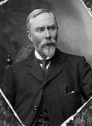
Sir Henry Francis Wigram was a New Zealand businessman, politician and aviation promoter. He is best known for his role in developing a public transport system in Christchurch and as a key player in the establishment of the Royal New Zealand Air Force.

The Christchurch Southern Motorway is the main southern route into and out of Christchurch, New Zealand. The motorway forms part of State Highway 1 and State Highway 76.

<span class="mw-page-title-main">Avonhead</span> Suburb in Christchurch, New Zealand

Avonhead is a suburb of the New Zealand city of Christchurch. It has two primary schools, a shopping centre and several parks.

<span class="mw-page-title-main">State Highway 73 (New Zealand)</span> Road in New Zealand

State Highway 73 is a major east-west South Island state highway in New Zealand connecting Christchurch on the east coast with Cass/Hokitika via the Southern Alps. It is mostly two lane, with some single-lane bridges north of Springfield but is mostly dual carriageway in Christchurch. The fourth and fifth-highest points of New Zealand's state highway network are on this road at Porters Pass and Arthur's Pass respectively.

<span class="mw-page-title-main">Aidanfield</span> Suburb in Christchurch, New Zealand

Aidanfield is a suburb in the south-west of Christchurch, New Zealand, about 8 kilometres (5.0 mi) from the city centre. The land, which had been owned by the Good Shepherd Sisters since 1886, now incorporates the Mount Magdala Institute and the St John of God Chapel, which has a Category I heritage listing by the New Zealand Historic Places Trust. The first residents moved into the suburb in 2002. The developer caused controversy in 2007–2008 by applying to have a group of farm buildings demolished to allow for further subdivision. Christchurch City Council was widely criticised for approving the demolition despite the buildings having had a heritage listing in the Christchurch City Plan.

<span class="mw-page-title-main">Mangere Aerodrome</span>

Mangere Aerodrome, named after a nearby suburb, was the original home of the Auckland Aero Club. It is now the site of Auckland Airport. Mangere Aerodrome's claim to fame was as the arrival point for New Zealand aviator, and aeroclub member, Jean Batten's solo flight from the United Kingdom in 1936. The RNZAF requisitioned the aerodrome from 1939 until 1944, renaming it RNZAF Station Mangere. In 1961, the Auckland Aero Club moved to Ardmore aerodrome and Mangere Aerodrome closed. The new Auckland Airport opened in 1965.

<span class="mw-page-title-main">Sockburn, New Zealand</span> Suburb in Christchurch, New Zealand

Sockburn is an industrial suburb of Christchurch, New Zealand, located between Hornby and Riccarton, some 7 kilometres (4.3 mi) west of the Christchurch city centre. The suburb is roughly bounded by the triangle formed by State Highway 1 in the west, Main South Road (SH73a) in the south and SH73 in the north. The suburb of Wigram, containing the city's former RNZAF base, is located nearby. One of the city's main horseracing circuits, Riccarton Racecourse, is located close to Sockburn's northern edge, and Racecourse was the initial name for the area. The name Sockburn is likely to have come from the village of Sockburn in County Durham, England.

<span class="mw-page-title-main">History of aviation in New Zealand</span> Aviation History

The history of aviation in New Zealand began in the late 19th century when balloon flights began. In the first decade of the 20th century, several New Zealanders began developing heavier-than-air craft with the first confirmed powered flight in New Zealand being made by Vivian Walsh in 1911. The First World War spurred the development of aviation in New Zealand. A flying school was established and several hundred New Zealanders went on to serve in British flying services in Europe.

<span class="mw-page-title-main">Hillmorton, New Zealand</span> Suburb in Christchurch, New Zealand

Hillmorton is a suburb of south-western Christchurch, New Zealand. The suburb is centred around the intersection of Lincoln Road and Hoon hay Road, two arterial routes which form part of State Highway 75 and feed into the Christchurch Southern Motorway which runs to the north of the suburb.

<span class="mw-page-title-main">Territorial Air Force (New Zealand)</span> Volunteer air force

The Territorial Air Force, or TAF, is a reserve air force that operates in New Zealand. The service traces its lineage back to a 1919 report that proposed an air force for the country manned by part-time volunteers, with the first recruits arriving in 1923. However, it was not until 1930 that the Territorial Air Force was formally constituted. The pilots had all previously served with the Royal Air Force, many in the First World War. Structurally, the force consisted of a wing of four squadrons, each allocated to one of the major cities of the country, with major sites at Auckland, Christchurch, Dunedin and Wellington. The Territorial Air Force suffered from a lack of equipment, particularly aircraft, throughout its existence. Initially, it relied on aircraft operated by the New Zealand Permanent Air Force, including obsolete examples that had been provided as part of the Imperial Gift, until a batch of second-hand Blackburn Baffin were purchased to provide both training and combat service. The Territorial Air Force was absorbed into the Royal New Zealand Air Force with the start of the Second World War. At the end of the war, an expanded network was originally envisaged, but the revived version of 1948 retained its structure of four squadrons. The TAF's flying squadron lasted only another nine years before the force was reduced to providing non-flying personnel like air traffic controllers and band members.

<span class="mw-page-title-main">Installations of the United States Navy in New Zealand</span> Former naval bases of the United States in New Zealand

The United States Navy maintained a number of naval installations in New Zealand during the Pacific War of World War II.

<span class="mw-page-title-main">Guy Newton (RNZAF officer)</span> New Zealander flying ace

Percival Guy Haig Newton, was a flying ace of the Royal New Zealand Air Force (RNZAF) during the Second World War. He was credited with the destruction of at least five enemy aircraft.

References

  1. "Wards, Councillors and Community Boards map". ccc.govt.nz. Christchurch City Council. Retrieved 14 August 2020.
  2. 1 2 "ArcGIS Web Application". statsnz.maps.arcgis.com. Retrieved 20 September 2021.
  3. "Population estimate tables - NZ.Stat". Statistics New Zealand . Retrieved 25 October 2022.
  4. "Christchurch Place Names: N–Z" (PDF). Retrieved 6 June 2021.
  5. "North and west Christchurch" . Retrieved 6 June 2021.
  6. "Wigram Air Base" . Retrieved 6 June 2021.
  7. "First trans-Tasman flight touches down" . Retrieved 22 June 2021.
  8. "90 years since New Zealand's first International flight landed at Wigram" . Retrieved 22 June 2021.
  9. "15 October 1953: The worst RNZAF air accident in New Zealand" . Retrieved 22 June 2021.
  10. "Memory of air crash loss set in stone". 15 October 2018. Retrieved 22 June 2021.
  11. "Wigram Airbase Timeline". Christchurch City Libraries. Retrieved 3 September 2018.
  12. "Historic Wigram Aerodrome closed". RNZ. Radio New Zealand. 28 February 2009. Retrieved 15 August 2020.
  13. "About Wigram Skies". wigramskies.co.nz. Ngāi Tahu Property. Retrieved 15 August 2020.
  14. "RW Agenda 12 July 2005" (PDF). Retrieved 19 June 2021.
  15. "Christchurch Street Names: L" (PDF). Retrieved 19 June 2021.
  16. "Christchurch Place Names: H" (PDF). Retrieved 19 June 2021.
  17. "Housing on land not needed for motorway". 23 October 2013. Retrieved 19 June 2021.
  18. "Riccarton Wigram Community Board Agenda 16 December 2014" (PDF). Retrieved 19 June 2021.
  19. "Christchurch Street Names: F to G" (PDF). Retrieved 19 June 2021.
  20. 1 2 "Address and Postcode Finder" . Retrieved 13 June 2021.
  21. Canterbury: the rebuild by the numbers (PDF). Wellington, New Zealand: Statistics New Zealand. February 2018. ISBN   978-1-98-852858-8.
  22. 1 2 "Statistical area 1 dataset for 2018 Census". Statistics New Zealand. March 2020. Awatea North (321900), Wigram North (322500), Wigram West (322800), Awatea South (322900), Wigram South (323600), Wigram East (324100) and Broken Run (324700).
  23. 2018 Census place summary: Wigram North
  24. 2018 Census place summary: Wigram West
  25. 2018 Census place summary: Wigram South
  26. 2018 Census place summary: Wigram East
  27. 2018 Census place summary: Awatea North
  28. 2018 Census place summary: Awatea South
  29. 2018 Census place summary: Broken Run
  30. "Place Summaries Christchurch City" . Retrieved 5 June 2021.
  31. "The Landing" . Retrieved 3 June 2021.
  32. "The Landing at Wigram moves ahead" . Retrieved 3 June 2021.
  33. "Christchurch's Landing takes shape" . Retrieved 3 June 2021.
  34. "New Zealand-owned cinema to open in Christchurch in July" . Retrieved 3 June 2021.
  35. "Tenanted industrial property on sale as owner-occupier moves on" . Retrieved 20 June 2021.
  36. 1 2 "Wigram Business Park" . Retrieved 20 June 2021.
  37. "Modern warehouse in Christchurch Business Park" . Retrieved 20 June 2021.
  38. "New Skellerup plant in Wigram" . Retrieved 20 June 2021.
  39. "2016 Annual Shareholders Meeting final" (PDF).
  40. "Wigram Magdala Link Bridge" . Retrieved 17 June 2021.
  41. "Wigram Magdala Link opens" . Retrieved 17 June 2021.
  42. "Metro Christchurch" . Retrieved 17 June 2021.
  43. "Greater Christchurch Metro" . Retrieved 17 June 2021.
  44. 1 2 3 4 "MetroInfo Interactive Network Map" . Retrieved 17 June 2021.
  45. "About our Museum" . Retrieved 18 June 2021.
  46. "Archives New Zealand to rebuild Christchurch facility" . Retrieved 22 June 2021.
  47. "Archives NZ new Christchurch repository officially opened" . Retrieved 18 June 2021.
  48. "Opening of Nga Puna Wai a milestone – Nga Puna Wai Sports Hub" . Retrieved 5 June 2021.
  49. "Sport Canterbury – Ngā Puna Wai Events" . Retrieved 5 June 2021.
  50. "New indoor Christchurch netball, futsul centre to go at Ngā Puna Wai" . Retrieved 5 June 2021.
  51. "CANTERBURYAGRICULTURAL PARK" . Retrieved 11 June 2021.
  52. "The Canterbury Agricultural and Pastoral Association Show" . Retrieved 11 June 2021.
  53. "Wigram Skies" . Retrieved 5 June 2021.
  54. "HALSWELL WIGRAM RUGBY" . Retrieved 22 June 2021.
  55. "Parera Park" . Retrieved 5 June 2021.
  56. "Tautoru Park – Wigram Skies" . Retrieved 5 June 2021.
  57. "West Broken Run Reserve planting days" . Retrieved 11 June 2021.
  58. "Lady Wigram Village" . Retrieved 13 June 2021.
  59. "Unique model of retirement living: Lady Wigram Retirement Village" . Retrieved 13 June 2021.
  60. "Summerset opens $80m retirement village in Christchurch" . Retrieved 13 June 2021.
  61. "Summerset at Wigram" . Retrieved 13 June 2021.
  62. "About – Wigram Te Piki Kāhu" . Retrieved 3 June 2021.
  63. Education Counts: Wigram Primary School - Te Piki Kāhu
  64. "New Zealand Schools Directory". New Zealand Ministry of Education. Retrieved 12 December 2022.
  65. "Miscellaneous Local Historical Information" (PDF). Christchurch City Libraries. p. 176. Retrieved 20 September 2021.
  66. 1 2 "Wards, Councillors and Community Boards map" . Retrieved 19 June 2021.
  67. "Christchurch City Council 2019 Election Results" . Retrieved 19 June 2021.
  68. "New Christchurch city councillor to focus on families" . Retrieved 19 June 2021.
  69. "2020 General Election electorates" . Retrieved 19 June 2021.
  70. "Hon Dr Megan Woods" . Retrieved 19 June 2021.