Corsican is a Romance language constituted by the continuum of the Italo-Dalmatian dialects spoken on the Mediterranean island of Corsica (France) and on the northern end of the island of Sardinia (Italy). Corsican is related to the Tuscan varieties from the Italian peninsula, and therefore also to the Florentine-based standard Italian.
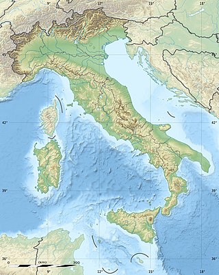
The geography of Italy includes the description of all the physical geographical elements of Italy. Italy, whose territory largely coincides with the homonymous geographical region, is located in southern Europe and comprises the long, boot-shaped Italian Peninsula crossed by the Apennines, the southern side of Alps, the large plain of the Po Valley and some islands including Sicily and Sardinia. Italy is part of the Northern Hemisphere. Two of the Pelagie Islands are located on the African continent.

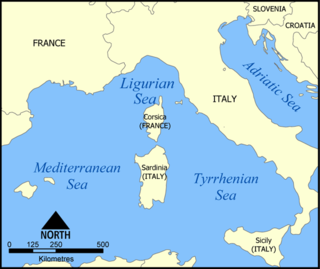
The Tyrrhenian Sea is part of the Mediterranean Sea off the western coast of Italy. It is named for the Tyrrhenian people identified with the Etruscans of Italy.

Gallura is a region in North-Eastern Sardinia, Italy.

La Maddalena is a town and comune located on the islands of the Maddalena archipelago in the province of Sassari, northern Sardinia, Italy.

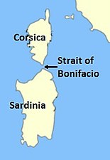
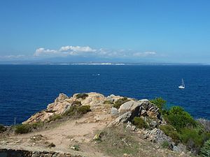
Bonifacio is a commune in the southern tip of the island of Corsica, in the French department of Corse-du-Sud.

The Maddalena Archipelago is a group of islands in the Strait of Bonifacio between Corsica (France) and Sardinia (Italy). The whole archipelago makes the territory of the La Maddalena comune in Sardinia.

The Corsicans are a Romance ethnic group. They are native to Corsica, a Mediterranean island and a territorial collectivity of France.

Corsica is an island in the Mediterranean Sea and one of the 18 regions of France. It is the fourth-largest island in the Mediterranean and lies southeast of the French mainland, west of the Italian Peninsula and immediately north of the Italian island of Sardinia, which is the land mass nearest to it. A single chain of mountains makes up two-thirds of the island. As of January 2023, it had a population of 351,255.

The Archipelago of Lavezzi is a collection of small granite islands and reefs in the Strait of Bonifacio that separates Corsica from Sardinia in the Mediterranean Sea. They are administered from the town of Bonifacio on Corsica.

The history of Corsica in the medieval period begins with the collapse of the Western Roman Empire and the invasions of various Germanic peoples in the fifth century AD, and ends with the complete subjection of the island to the authority of the Bank of San Giorgio in 1511.

The history of Corsica goes back to antiquity, and was known to Herodotus, who described Phoenician habitation in the 6th century BCE. Etruscans and Carthaginians expelled the Phoenicians, and remained until the Romans arrived during the Punic Wars in 237 BCE. Vandals occupied it in 430 CE, followed by the Byzantine Empire a century later.

The flag of Corsica was adopted by General of the Nation Pasquale Paoli in 1755 and was based on a traditional flag used previously. It portrays a Moor's head in black wearing a white bandana above his eyes on a white background. Previously, the bandana covered his eyes; Paoli wanted the bandana moved to above the eyes to symbolise the liberation of the Corsican people from the Genoese.

The prehistory of Corsica is analogous to the prehistories of the other islands in the Mediterranean Sea, such as Sicily, Sardinia, Malta and Cyprus, which could only be accessed by boat and featured cultures that were to some degree insular; that is, modified from the traditional Paleolithic, Mesolithic, Neolithic and Chalcolithic of European prehistoric cultures. The islands of the Aegean Sea and Crete early developed Bronze Age civilizations and are accordingly usually treated under those categories. Stone Age Crete however shares some of the features of the prehistoric Mediterranean islands.
Cavallo is a small island in the Mediterranean Sea located between Corsica and Sardinia. Cavallo is the southernmost inhabited territory of metropolitan France and part of the commune of Bonifacio, Corsica.
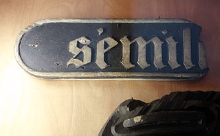
The Sémillante was a Surveillante class 60-gun first rank frigate of the French Navy. She sank off the coast of Corsica in 1855 with a loss of 693 people.

The Kingdom of Sardinia, also referred to as the Kingdom ofSardinia-Piedmont or Piedmont-Sardinia during the Savoyard period, was a state in Southern Europe from the early 14th until the mid-19th century.

The Defensive Organization of Corsica was the French military organization that in 1940 was responsible for the defense of the French island of Corsica against a potential invasion by Fascist Italy. As part of the overall effort to fortify France's borders which included the Maginot Line, the fixed Corsican defenses were constructed in parallel with the Maginot Line, using the same organizational structure and similar designs, albeit scaled back in size, cost and fighting power. The Corsican defenses were designed to deter an Italian landing on the south end of Corsica, and to support artillery batteries capable of controlling the Strait of Bonifacio between Corsica and the Italian island of Sardinia, separated by only twelve kilometers. As World War II unfolded, no attempt was made by Italian forces to mount an opposed landing on Corsica. The island was instead occupied in November 1942. In 1943 Corsica saw fighting when German forces moved from Sardinia. Most of the fortified positions remain to the present day.
Italian-occupied Corsica refers to the military occupation by the Kingdom of Italy of the island of Corsica during the Second World War, from November 1942 to September 1943. After an initial period of increased control over the island, by early spring 1943 the Maquis had begun to occupy the hinterland. In the aftermath of the Armistice of Cassibile, the Italian capitulation to the Allies, some Italian units sided with German troops sent to replace the Italian garrison and some defected to the Maquis and Free French Forces.

Italy has the world's 48th largest exclusive economic zone (EEZ), with an area of 541,915 km2 (209,235 sq mi). It claims an EEZ of 200 nmi from its shores, which has long coastlines with the Tyrrhenian Sea to the west, the Ionian Sea to the south and the Adriatic Sea to the east. Its EEZ is limited by maritime boundaries with neighboring countries to the north-west, east and southeast.