Sutro Heights Park

Last updated

Sutro Heights Park
SutroHeightsPark.jpg
Location map San Francisco County.png
Red pog.svg
Sutro Heights Park
Relief map of California.png
Red pog.svg
Sutro Heights Park
Usa edcp relief location map.png
Red pog.svg
Sutro Heights Park
Location Richmond District, San Francisco, California
Coordinates 37°46′42″N122°30′40″W / 37.7782632°N 122.5110838°W / 37.7782632; -122.5110838 [1]
Area18 acres (7.3 ha) [2]
Operated by Golden Gate National Recreation Area

Sutro Heights Park is an historic public park in the Outer Richmond District of western San Francisco, California. [3] It is within the Golden Gate National Recreation Area and the Sutro Historic District. [4]

Contents

It is located above the Cliff House in the Lands End area, with views of the Seal Rocks, Ocean Beach, and the Pacific Ocean.

History

Entrance to Sutro Heights gardens, 1895 Adolph Sutro (1895) (14578389689).jpg
Entrance to Sutro Heights gardens, 1895
Sutro Heights gardens, 1895 Adolph Sutro (1895) (14578391159).jpg
Sutro Heights gardens, 1895
Street map, 1937 Sutro Heights.jpg
Street map, 1937
From observation plaza, towards the second Cliff House Review of reviews and world's work (1890) (14598310127).jpg
From observation plaza, towards the second Cliff House

The 18-acre (7.3-hectare) park is on the site of the former "Sutro Heights" estate of Adolph Sutro, a Comstock Lode silver baron, and a major land owner/developer in and mayor of San Francisco. [5] [6]

In 1881, Adolf Sutro purchased 22 acres (8.9 ha) of undeveloped land south of Point Lobos (San Francisco) and north of Ocean Beach at the western edge of the city. It included a promontory overlooking the Pacific, with scenic views of the Marin Headlands, Mount Tamalpais, and the Golden Gate. Sutro built his mansion on a rocky ledge there, above the first Cliff House.

The grounds consisted of a spacious turreted mansion, a carriage house, and outbuildings set in expansive gardens. The estate dominated the Lands End area, with an elaborate entrance gate. He spent in excess of a million dollars to recreate an Italian style garden. It was filled with fountains, planted urns, and statues, Victorian flower beds, hedge mazes, parterres, forests of trees, a glass plant conservatory, and other garden structures. Vista points included the "observation plaza" overlooking the Cliff House, and the "Dolce far Niente Balcony," a long terrace-like structure along the cliff overlooking Ocean Beach. [5] To provide garden decorations, he imported over 200 concrete replicas of Greek and Roman statuary from Belgium, to provide examples of European culture to visitors. [7]

By 1883 Sutro opened his estate's gardens, named Sutro Heights, to the public and allowed strolling the grounds for the donation of a dime. That small fee helped to pay the 17 gardeners, machinists, and drivers he employed to maintain the grounds. [5]

Other features he developed on his land holdings in the Lands End area include: the Sutro Baths (1894-1964), [8] the second and elaborate Victorian style Cliff House (1896-1907) [9] and an amusement park named Sutro Pleasure Grounds at Merrie Way (1896-1898). [10] To provide inexpensive transportation for visitors to these he built a passenger steam train from downtown San Francisco to Lands End. [11]

Adolph Sutro died in 1898, land rich but cash poor following his frustrating tenure as Mayor of San Francisco. His daughter Emma Sutro Merritt moved to the Sutro Heights estate then. As she aged she could not maintain the grounds, and the house became seriously deteriorated, though she lived there until her death in 1938. [7] Throughout the 1920s, ‘30s, and ‘40s, people took away many of the rose garden plantings and vandalized the statues. [7] [12]

Park

The Sutro family donated the estate to the City of San Francisco in 1938. In 1939 the Works Progress Administration (WPA) demolished the residence. [7] Remaining statuary was removed, with the exception of The Lions, copies of those in London's Trafalgar Square at the entrance gate, and a statue of Diana the Huntress (Artemis), a concrete copy of the Louvre's Diana, itself a Roman copy of a Greek statue. [13] The 18 acres (7.3 ha) city park then opened.

Sutro Heights Park is no longer a city park, it is part of the Golden Gate National Recreation Area. It is maintained by a neighborhood group, Friends of the GGNRA, many of whom live on the surrounding streets. [7] [14]

Cliff House, Seal Rocks, and statue in Sutro Heights, c. 1896-1907 Cliff House and Seal Rocks, San Francisco, Cal, from Robert N. Dennis collection of stereoscopic views 3.jpg
Cliff House, Seal Rocks, and statue in Sutro Heights, c.1896-1907
Second Cliff House from Sutro Heights gardens, c. 1896-1907 Cliff House, Seal Rocks, and Pacific Ocean, from Sutro Heights, San Francisco, California, from Robert N. Dennis collection of stereoscopic views.jpg
Second Cliff House from Sutro Heights gardens, c. 1896-1907

See also

Related Research Articles

<span class="mw-page-title-main">Richmond District, San Francisco</span> Neighborhood in San Francisco, California, United States

The Richmond District is a neighborhood in the northwest corner of San Francisco, California, developed initially in the late 19th century. It is sometimes confused with the city of Richmond, which is 20 miles (32 km) northeast of San Francisco.

<span class="mw-page-title-main">Adolph Sutro</span> American politician

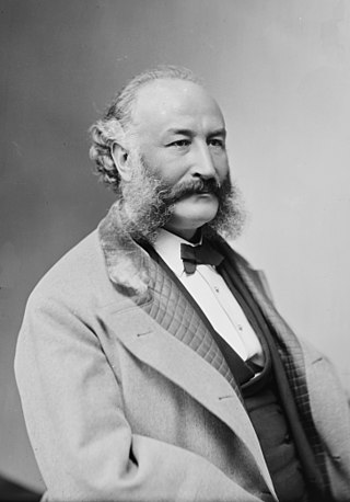
Adolph Heinrich Joseph Sutro was a German-American engineer, politician and philanthropist who served as the 24th mayor of San Francisco from 1895 until 1897. Born a German Jew, he moved to Virginia City, Nevada and made a fortune at the Comstock Lode. Several places in San Francisco bear his name in remembrance of his life and contributions to the city.

<span class="mw-page-title-main">Sutro Baths</span> Large defunct saltwater swimming pool complex in San Francisco, now ruins.

<span class="mw-page-title-main">Ocean Beach, San Francisco</span> Beach on the west coast of San Francisco, California, bordering the Pacific Ocean

Ocean Beach is a beach on the west coast of San Francisco, California, United States, bordering the Pacific Ocean. It is adjacent to Golden Gate Park, the Richmond District, and the Sunset District. The Great Highway runs alongside the beach, and the Cliff House and the site of the former Sutro Baths sit at the northern end. The beach is a part of the Golden Gate National Recreation Area, which is administered by the National Park Service.

<span class="mw-page-title-main">Geary Boulevard</span> Thoroughfare in San Francisco, United States

Geary Boulevard is a major east–west 5.8-mile-long (9 km) thoroughfare in San Francisco, California, United States, beginning downtown at Market Street near Market Street's intersection with Kearny Street, and running westbound through downtown, the Civic Center area, the Western Addition, and running for most of its length through the predominantly residential Richmond District. Geary Boulevard terminates near Sutro Heights Park at 48th Avenue, close to the Cliff House above Ocean Beach at the Pacific Ocean. At 42nd Avenue, Geary intersects with Point Lobos Avenue, which takes through traffic to the Cliff House, Ocean Beach and the Great Highway. It is a major commercial artery through the Richmond District; it is lined with stores and restaurants, many of them catering to the various immigrant groups who live in the area. The boulevard borders Japantown between Fillmore and Laguna Streets.

<span class="mw-page-title-main">Cliff House, San Francisco</span> Landmark building (built 1863)

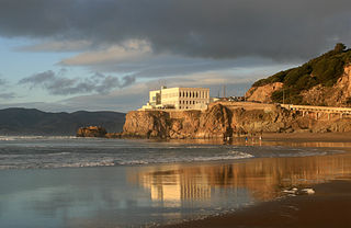
The Cliff House is a neo-classical style building perched on the headland above the cliffs just north of Ocean Beach, in the Outer Richmond neighborhood of San Francisco, California. The building overlooks the site of the Sutro Baths ruins, Seal Rocks, and is part of the Golden Gate National Recreation Area, operated by the National Park Service (NPS). The Cliff House is owned by the NPS; the building's terrace hosts a room-sized camera obscura.

<span class="mw-page-title-main">Seal Rocks (San Francisco, California)</span> Rock islands in Pacific Ocean in western San Francisco, California

Seal Rock is a group of small rock formation islands in the Lands End area of the Outer Richmond District in western San Francisco, California. They are located just offshore in the Pacific Ocean, at the north end of the Ocean Beach, near the Cliff House and Sutro Baths ruins.

<span class="mw-page-title-main">Golden Gate National Recreation Area</span> U.S. National Recreation Area surrounding San Francisco Bay Area

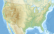
The Golden Gate National Recreation Area (GGNRA) is a U.S. National Recreation Area protecting 82,116 acres (33,231 ha) of ecologically and historically significant landscapes surrounding the San Francisco Bay Area. Much of the park is land formerly used by the United States Army. GGNRA is managed by the National Park Service and is the second-most visited unit of the National Park system in the United States, with more than 15.6 million visitors in 2022. It is also one of the largest urban parks in the world, with a size two-and-a-half times that of the consolidated city and county of San Francisco.

<span class="mw-page-title-main">James P. Delgado</span> American maritime archaeologist, explorer and author

James Preston Delgado is a maritime archaeologist, historian, maritime preservation expert, author, television host, and explorer.

<span class="mw-page-title-main">Playland (San Francisco)</span> Amusement park in California, 1921 to 1972

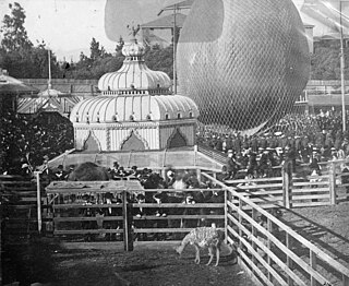
Playland was a 10-acre (40,000-square-meter) seaside amusement park located next to Ocean Beach, in the Richmond District at the western edge of San Francisco, California, along Great Highway, bounded by Balboa and Fulton streets. It began as a collection of amusement rides and concessions in the late 19th century, and was preceded by Chutes at the Beach, opened in 1921. Playland closed Labor Day weekend in 1972.

Founded in 1981, the Golden Gate National Parks Conservancy is a nonprofit cooperating association that supports park stewardship and conservation in the Golden Gate National Recreation Area—the most visited national park in the U.S.

<span class="mw-page-title-main">Fort Funston</span>

Fort Funston is a former harbor defense installation located in the southwestern corner of San Francisco. Formerly known as the Lake Merced Military Reservation, the fort is now a protected area within the Golden Gate National Recreation Area (GGNRA). It was named in honor of Frederick N. Funston (1865–1917), a Major General in the United States Army with strong connections to San Francisco, and included several artillery batteries. The fort is located on Skyline Boulevard at John Muir Drive, west of Lake Merced.

<span class="mw-page-title-main">Camera Obscura (San Francisco, California)</span> United States historic place

The Camera Obscura is a large-scale camera obscura, in the Lands End area of the Outer Richmond District in western San Francisco, California.

<span class="mw-page-title-main">Sutro District</span> National Park Service historic district in western San Francisco within the GGNRA

The Sutro Historic District is a National Park Service historic district in the Lands End area of the Outer Richmond District in western San Francisco, California. It is within the Golden Gate National Recreation Area, since being acquired by the National Park Service in 1977.

<span class="mw-page-title-main">Lands End (San Francisco)</span> Park within the Golden Gate National Recreation

Lands End is a park in San Francisco within the Golden Gate National Recreation Area. It is a rocky and windswept shoreline at the mouth of the Golden Gate, situated between the Sutro District and Lincoln Park and abutting Fort Miley Military Reservation. A memorial to USS San Francisco stands in the park. Numerous hiking trails follow the former railbeds of the Ferries and Cliff House Railway along the cliffs and also down to the shore.

Rancho Corral de Tierra was a 7,766-acre (31.43 km2) Mexican land grant in present-day coastal western San Mateo County, northern California.

<span class="mw-page-title-main">Kirby Cove Camp</span> Campground in California, United States

Kirby Cove Camp is a campground and scenic area managed by the Golden Gate National Recreation Area (GGNRA) in the Marin Headlands, California. It is located at sea level below Conzelman Road, which leads from the north end of the Golden Gate Bridge up and along the Marin Headlands overlooking the Golden Gate strait that leads into San Francisco Bay. A road behind a locked gate leads to Kirby Cove from just beyond Battery Spencer, the first set of bunkers encountered from Highway 101 at the north end of the Golden Gate Bridge.

<span class="mw-page-title-main">Woodward's Gardens</span> 19th-century amusement park in San Francisco, California

Woodward's Gardens, commonly referred to as The Gardens, was a combination amusement park, museum, art gallery, zoo, and aquarium operating from 1866 to 1891 in the Mission District of San Francisco, California. The Gardens covered two city blocks, bounded by Mission, Valencia, 13th, and 15th Streets in San Francisco. The site currently has a brick building at 1700 Mission Street, built after the 1906 San Francisco earthquake, which features a California Historical Site plaque, and the Crafty Fox Alehouse on the ground floor. The former Gardens site also features the current location of the San Francisco Armory, completed in 1914.

References

  1. "Sutro Heights Park". Geographic Names Information System . United States Geological Survey, United States Department of the Interior.
  2. "Sutro Heights Park". SFWeekly. Retrieved June 27, 2011.
  3. Todd, Gail (January 21, 2010). "Sutro Heights Park, San Francisco". SFGate.com. Retrieved June 27, 2011.
  4. NPS-GGNRA: Sutro Historic District
  5. 1 2 3 U.S. National Park Service, Golden Gate National Recreation Area (GGNRA): Sutro Heights History
  6. NPS− GGNRA: Adolph Sutro
  7. 1 2 3 4 5 Sfcityguides.org: Sutro Heights Park
  8. NPS− GGNRA: Sutro Baths History
  9. NPS− GGNRA: Cliff House History
  10. NPS− GGNRA: Sutro Pleasure Grounds at Merrie Way
  11. NPS− GGNRA: Lands End, Adolph Sutro Develops Seaside Recreation
  12. The Sutro Heights residence is visible on the 1938 layer of Google Earth, located at 122°30'42.98"W 37°46'39.71"N.
  13. Sfcityguides.org: Diana Statue in Sutro Heights Park
  14. Parksconservancy.org: Park Stewardship in San Francisco