St. Croix County is a county in the U.S. state of Wisconsin. As of the 2010 census, the population was 84,345. Its county seat is Hudson. The county was created in 1840 and organized in 1849.
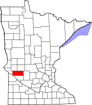
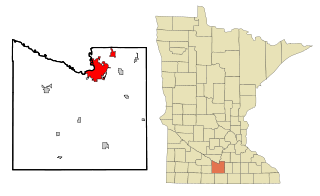
Swift County is a county in the U.S. state of Minnesota. As of the 2010 United States Census, the population was 9,783. Its county seat is Benson.

Little Falls is a city in Morrison County, Minnesota, United States, near the geographic center of the state. Established in 1848, Little Falls is one of the oldest European-American cities in Minnesota. It is the county seat of Morrison County. The population was 8,343 at the 2010 census. Little Falls was the boyhood home of noted aviator Charles Lindbergh. Just across from his former home is Charles A. Lindbergh State Park, named after Lindbergh's father, prominent Minnesota lawyer and U.S. Congressman Charles August Lindbergh.

Rochester is a city founded in 1854 in the U.S. State of Minnesota and is the county seat of Olmsted County located on the Zumbro River's south fork in Southeast Minnesota. It is Minnesota's third-largest city and the largest city located outside the Minneapolis-St. Paul Metropolitan Statistical Area. As of 2018, the Rochester metropolitan area had a population estimated at 219,802. According to the 2010 United States Census the city had a population of 106,769. The U.S. Census Bureau estimated that the 2018 population was 116,961. It is the home of the Mayo Clinic and a major IBM facility, one of the company's largest at its peak. The city has long been rated as one of the best places to live in the United States by multiple publications such as Money.
Fergus Falls is a city in and the county seat of Otter Tail County, Minnesota, United States. The population was 13,138 at the 2010 census.
Mankato is a city in Blue Earth, Nicollet, and Le Sueur counties in the state of Minnesota. The population was 42,610 according to 2018 US census estimates, making it the fifth largest city in Minnesota outside the Minneapolis–Saint Paul metropolitan area. The county seat of Blue Earth County, it is along a large bend of the Minnesota River at its confluence with the Blue Earth River. Mankato is across the Minnesota River from North Mankato. Mankato and North Mankato have a combined population of over 56,500 according to the 2018 census estimates. It completely encompasses the town of Skyline. North of Mankato Regional Airport, a tiny non-contiguous part of the city lies within Le Sueur County. Most of the city is in Blue Earth County.

Granite Falls is a city in Chippewa and Yellow Medicine counties in the State of Minnesota. The population was 2,897 at the 2010 census. It is the county seat of Yellow Medicine County. The Andrew John Volstead House, a National Historic Landmark, is located in Granite Falls.

Wadena is a city in Otter Tail and Wadena counties in the State of Minnesota. It is about one hundred sixty miles northwest of the Minneapolis – Saint Paul metro area. The population was 4,088 at the 2010 census. It is the county seat of Wadena County.

Tornado is a census-designated place (CDP) in Kanawha County, West Virginia, United States. Tornado is also known as "Upper Falls", the name recognized by the U.S. Census Bureau at the time of the 2010 census. The United States Board on Geographic Names declared the community's official name to be Tornado in 2013 due to a request from the Kanawha County Commission, which determined that residents of the community supported the name Tornado over Upper Falls. It is also known as "Andrews Heights", "Big Bend" and "Upper Falls of Coal River".

West Albany is an unincorporated community in West Albany Township, Wabasha County, Minnesota, United States.

Minnesota has a humid continental climate, with hot summers and cold winters. Minnesota's location in the Upper Midwest allows it to experience some of the widest variety of weather in the United States, with each of the four seasons having its own distinct characteristics. The area near Lake Superior in the Minnesota Arrowhead region experiences weather unique from the rest of the state. The moderating effect of Lake Superior keeps the surrounding area relatively cooler in the summer and warmer in the winter, giving that region a smaller yearly temperature range. On the Köppen climate classification, much of the southern third of Minnesota—roughly from the Twin Cities region southward—falls in the hot summer zone (Dfa), and the northern two-thirds of Minnesota falls in the warm summer zone (Dfb).

The Great Storm of 1975 was an intense storm system that impacted a large portion of the Central and Southeast United States from January 9 to January 12, 1975. The storm produced 45 tornadoes in the Southeast U.S. resulting in 12 fatalities, while later dropping over 2 feet (61 cm) of snow and killing 58 people in the Midwest. This storm remains one of the worst blizzards to ever strike parts of the Midwest, as well as one of the largest January tornado outbreaks on record in the United States.
Oak Center is an unincorporated community in Gillford Township, Wabasha County, Minnesota, United States.
Franconia is an unincorporated community in Franconia Township, Chisago County, Minnesota, United States.
Jarrett is an unincorporated community in Wabasha County, Minnesota, United States.
Dumfries is an unincorporated community in Glasgow Township, Wabasha County, Minnesota, United States.
Bear Valley is an unincorporated community in Chester Township, Wabasha County, Minnesota, United States.
Clinton Falls is an unincorporated community in Clinton Falls Township, Steele County, Minnesota, United States.

Terrace is an unincorporated community in Chippewa Falls Township, Pope County, Minnesota, United States. The community was settled in the 1870s around the Terrace Mill. In 1982 a historic district of early buildings and structures was listed on the National Register of Historic Places as the Terrace Historic District for having local significance under the themes of exploration/settlement and industry. It was nominated as a well-preserved example of the small communities that grew up around Minnesota's rural mills in the latter 19th century.