Swithland

Last updated

Swithland
Main street,Swithland 2006-04-04 043web.jpg
Main Street, Swithland
Leicestershire UK location map.svg
Red pog.svg
Swithland
Location within Leicestershire
Population230 (2004 population estimate) [1]
OS grid reference SK549131
District
Shire county
Region
Country England
Sovereign state United Kingdom
Post town Loughborough
Postcode district LE12
Dialling code 01509
Police Leicestershire
Fire Leicestershire
Ambulance East Midlands
UK Parliament
List of places
UK
England
Leicestershire
52°42′48″N1°11′17″W / 52.713228°N 1.188036°W / 52.713228; -1.188036

Swithland is a linear village in the Charnwood borough of Leicestershire, England. The civil parish population was put at 230 in 2004 and 217 in the 2011 census. [2] It is in the old Charnwood Forest, between Cropston, Woodhouse and Woodhouse Eaves. It has a village hall, a parish church and a public house, the Griffin Inn. The village is known for the slate that was quarried in the area.

Contents

History

Swithland was originally held by Groby. Part of the village had become held by the Danvers (originally called D'Anvers) family by 1412, and between 1509 and 1796, the whole village was held by the Danvers family. [3] The village includes the 13th-century St Leonard's parish church, which retains the original arcades and has an 18th-century west tower built for Sir John Danvers. [4] It includes monuments to Agnes Scott, Sir John Danvers (actually installed on Danvers's instruction six years before his death) and five of his children. [4] The churchyard of St. Leonard's includes the tomb of Sir Joseph Danvers, 1st Baronet (1686–1753), which was built half inside the graveyard and half outside (on Danvers' estate) to allow his favourite dog to be buried with him (the dog being buried on unconsecrated ground). [5]

Swithland was designated a conservation area in 1993, and includes 31 listed buildings, including the Grade I Mountsorrel Cross, and several Grade II buildings, including the school, which was built in 1843, and a cottage from 1842. [6] [7] The village pub, the Griffin Inn, originally the Griffin Hotel, was built about 1700 and has been put to several uses in its history, including a brewery, bakery, and village mortuary. Most recently, it has had the inclusion of local producer Deli sourcing 80% of their products from within 40 miles. An annual village fair was held in Victorian times outside the pub on the Feast of St Leonard in November. [8]

Swithland Estate

Boundary tower from the original Swithland Hall site SwithlandEastTurret.JPG
Boundary tower from the original Swithland Hall site
The c.1500 Mountsorrel Cross that was moved to Swithland in the 18th century MountsorrelCross web.JPG
The c.1500 Mountsorrel Cross that was moved to Swithland in the 18th century
St Leonard's church, Swithland St Leonards church 2006-04-04 039web.jpg
St Leonard's church, Swithland

The Swithland Hall estate was held by the family of Danvers until 1796 but after the death of Sir John Danvers (the last male of his line) it passed to his son-in-law, Augustus Richard Butler, second son of the second Earl of Lanesborough, who adopted the surname of Danvers-Butler and afterwards inherited the title of Earl of Lanesborough.

The original Swithland Hall, which stood at the eastern end of the village as it is today, on the site now occupied by Hall Farm, was destroyed by fire in 1822, although part of the hall's boundary wall, including two towers are still in existence, both of which are in Main Street. [6] [9] The current hall, a Grade II listed building, was partially completed in 1834 and finished in 1852, [10] on a different site to the south-east, in what was then known as Swithland Park, by John George Danvers Butler, sixth Earl of Lanesborough. [3] [11] The estate includes the Mountsorrel Cross that originally stood in Mountsorrel that dates from about 1500 and was moved to its current location in Swithland Park in 1793 by Sir John Danvers, who replaced it with the Buttermarket Cross that still stands there. [3] [12]

Swithland slate gravestone, Swithland churchyard Swithland slate gravestone,Swithland churchyard.jpg
Swithland slate gravestone, Swithland churchyard

Industry

Slate quarrying in the area dates back to Roman times, [13] and was an important activity within the village between the 13th and 19th centuries. [14] Until the mid-19th century, Swithland slate was much in demand for roofing. From the later 17th century until well into the 19th century, slate from Swithland was widely used for gravestones in Leicestershire and neighbouring counties, especially Nottinghamshire. The slate has a poorer cleavage than Welsh slate, but is often exquisitely carved. A distinguishing mark of Swithland slate is the rough texture of the uncarved face. Some gravestones were carved by members of the Hind family of Swithland, but many others were carved by masons elsewhere, to whom the raw slate was sent. [5] [15] One gravestone type found mainly in a group of villages in the Vale of Belvoir is called a "Belvoir Angel". [16] Slates from Swithland for roofing were once commonly used, but demand fell in favour of slates from Wales, which were thinner and lighter. [5] [17]

Since then the quarry has reverted to nature, with the slate pits now flooded and sometimes used by divers. [11] A memorial stone stands in the centre of the village. [14]

The land to the north and south of the village is used for farming, both arable and dairy. Swithland Spring Water, based at Hall Farm, sells locally bottled spring water, which is collected from a spring beneath the farm. [18]

Local attractions

Swithland Reservoir, completed in 1896, is the largest reservoir in Charnwood; it is situated to the north-east of the village. It is accessible via the causeway road to the east of the village and with a dam that can be reached by Kinchley Lane from Mountsorrel, and is a popular site for birdwatching, as well as for walking. Swithland Wood, to the south-west of the village, is near to Bradgate Park. This large area of woodland around a former slate quarry is a popular walking, riding, and hunting spot.

Great Central railway line

Towards the Rothley end of the village runs the Great Central Railway, the last main line ever built linking the north of England with London (apart from the HS2 line under construction in 2021). When the Great Central line opened on 15 March 1899, it was planned for Swithland to have its own station, the Great Central having visions of turning the area into a tourist spot. This never came into fruition, but a bricked-over stairway under the bridge of the railway provides evidence that these plans were taken into serious consideration. [19] A small set of railway exchange sidings were built at this location, but the nearest passenger station was at Rothley.

The preserved Great Central Railway is restoring these sidings to working order. The railway line extends to Leicester North to the south, and Quorn & Woodhouse and Loughborough to the north, crossing Swithland reservoir by a two-part viaduct.

Related Research Articles

<span class="mw-page-title-main">Leicestershire</span> County of England

Leicestershire is a ceremonial county in the East Midlands of England. It is bordered by Derbyshire, Nottinghamshire, and Lincolnshire to the north, Rutland to the east, Northamptonshire to the south-east, Warwickshire to the south-west, and Staffordshire to the west. The city of Leicester is the largest settlement and the county town.

<span class="mw-page-title-main">Quorn, Leicestershire</span> Village in Leicestershire, England

Quorn is a village and civil parish in Leicestershire, England, near the university town of Loughborough. Its name was shortened from Quorndon in 1889, to avoid postal difficulties owing to its similarity to the name of another village, Quarndon, in neighbouring Derbyshire.

<span class="mw-page-title-main">Borough of Charnwood</span> Borough and non-metropolitan district in England

Charnwood is a local government district with borough status in the north of Leicestershire, England. It is named after Charnwood Forest, much of which lies within the borough. The council is based in Loughborough, the area's largest town. The borough also contains the towns of Shepshed and Syston, along with numerous villages and surrounding rural areas. In the south of the borough it includes parts of the Leicester Urban Area, notably at Birstall and Thurmaston.

<span class="mw-page-title-main">Great Central Railway (heritage railway)</span> Heritage railway based in Loughborough, England

The Great Central Railway (GCR) is a heritage railway in Leicestershire, England, named after the company that originally built this stretch of railway. It runs for 8.25 miles (13.28 km) between the town of Loughborough and a new terminus in the north of Leicester. It has period signalling, locomotives and rolling stock.

<span class="mw-page-title-main">Bradgate Park</span> 850 acre public park

Bradgate Park is a public park in Charnwood Forest, in Leicestershire, England, northwest of Leicester. It covers 850 acres. The park lies between the villages of Newtown Linford, Anstey, Cropston, Woodhouse Eaves and Swithland. The River Lin runs through the park, flowing into Cropston Reservoir which was constructed on part of the park. To the north-east lies Swithland Wood. The park's two well known landmarks, Old John and the war memorial, both lie just above the 210 m (690 ft) contour. The park is part of the 399.3 hectare Bradgate Park and Cropston Reservoir Site of Special Scientific Interest, which has been designated under both biological and geological criteria.

<span class="mw-page-title-main">Charnwood Forest</span> Upland area in Leicestershire, England

Charnwood Forest is a hilly tract in north-western Leicestershire, England, bounded by Leicester, Loughborough and Coalville. The area is undulating, rocky and picturesque, with barren areas. It also has some extensive tracts of woodland; its elevation is generally 600 feet (180 m) and upwards, the area exceeding this height being about 6,100 acres (25 km2). The highest point, Bardon Hill, is 912 feet (278 m). On its western flank lies an abandoned coalfield, with Coalville and other former mining villages, now being regenerated and replanted as part of the National Forest. The M1 motorway, between junctions 22 and 23, cuts through Charnwood Forest.

<span class="mw-page-title-main">Mountsorrel</span> Human settlement in England

Mountsorrel is a village in Leicestershire on the River Soar, just south of Loughborough with a population in 2001 of 6,662 inhabitants, increasing to 8,223 at the 2011 census.

<span class="mw-page-title-main">Newtown Linford</span> Human settlement in England

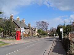
Newtown Linford is a linear village in Leicestershire, England. The population of the civil parish was 1,000 at the 2001 census, including Ulverscroft, increasing to 1,103 at the 2011 census.

<span class="mw-page-title-main">Swithland Wood and The Brand</span>

Swithland Wood and The Brand is a 87.9 hectares biological Site of Special Scientific Interest south of Woodhouse Eaves in Leicestershire. Swithland Wood is a Nature Conservation Review site, Grade II. The Brand is designated a Precambrian site in the Geological Conservation Review, but the dating has been changed due to the discovery of trace fossils from the succeeding Cambrian period.

<span class="mw-page-title-main">Charnwood (UK Parliament constituency)</span> UK Parliament constituency since 1997

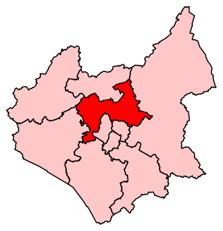
Charnwood is a constituency in Leicestershire represented in the House of Commons of the UK Parliament since 2015 by Edward Argar, a Conservative.

<span class="mw-page-title-main">Barrow upon Soar</span> Village in Leicestershire, England

Barrow upon Soar is a large village in northern Leicestershire, in the Soar Valley between Leicester and Loughborough, with a population at the 2011 census of 5,856.

<span class="mw-page-title-main">Redmile</span> Village in Leicestershire, England

Redmile is an English village and civil parish in the Melton district of Leicestershire, about ten miles (16 km) north of Melton Mowbray and seven miles (11 km) west of Grantham. The population of the civil parish, which includes Barkestone-le-Vale and Plungar, was 921 at the 2011 census, up from 829 in 2001.

<span class="mw-page-title-main">Knipton</span> Human settlement in England

Knipton is a village and former civil parish, now in the parish of Belvoir, in the Melton district, in the county of Leicestershire, England. It lies about 6 miles (10 km) from the town of Grantham, just off the A607, and 10 miles (16 km) from Melton Mowbray. It borders the Duke of Rutland's estate at Belvoir Castle. Although the village is in Leicestershire, it has a Nottinghamshire postcode and a Lincolnshire (Grantham) STD code. In 1931 the parish had a population of 273. On 1 April 1936 the parish was abolished and merged with Belvoir.

<span class="mw-page-title-main">Swithland Reservoir</span> Reservoir in Leicestershire

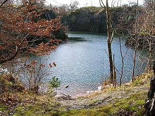
Swithland Reservoir is a reservoir in the English county of Leicestershire. It is north-east of the village of Swithland from which it takes its name, north-west of Rothley and approximately 133 metres (145 yd) south-west of Mountsorrel Quarry. It is part of the 187.1-hectare (462-acre) Buddon Wood and Swithland Reservoir Site of Special Scientific Interest (SSSI).

Swithland Sidings is a set of railway sidings on the preserved Great Central Railway, situated just south of Swithland Reservoir and Swithland Viaduct which crosses it.

<span class="mw-page-title-main">Mountsorrel Railway</span> Heritage railway in Leicestershire

The Mountsorrel Railway was a network of industrial railway lines that served the granite quarries which dominate the Leicestershire village of Mountsorrel. After being closed in the 1950s, a section was reopened in 2015 as a heritage line run by the Mountsorrel & Rothley Community Heritage Centre.

<span class="mw-page-title-main">Swithland Hall</span>

<span class="mw-page-title-main">St Mary's Church, Anstey</span> Church in United Kingdom

St Mary's Church is the Church of England parish church in Anstey, Leicestershire, in the Diocese of Leicester.

<span class="mw-page-title-main">Joseph Danvers</span>

Sir Joseph Danvers, 1st Baronet, of Swithland, Leicestershire, was an English politician who sat in the House of Commons from 1722 to 1747.

<span class="mw-page-title-main">Ledger stone</span> Grave marker

A ledger stone or ledgerstone is an inscribed stone slab usually laid into the floor of a church to commemorate or mark the place of the burial of an important deceased person. The term "ledger" derives from the Middle English words lygger, ligger or leger, themselves derived from the root of the Old English verb liċġan, meaning to lie (down). Ledger stones may also be found as slabs forming the tops of tomb chest monuments.

References

  1. 2004 Population Estimates, Leicestershire County Council, retrieved 2010-07-23
  2. "Civil Parish population 2011". Neighbourhood Statistics. Office for National Statistics. Retrieved 22 June 2016.
  3. 1 2 3 C. N. Hadfield (1952), Charnwood Forest – a Survey, Edgar Backus, pp. 59–60.
  4. 1 2 Pevsner, Nikolaus (1960) The Buildings of England: Leicestershire and Rutland, Penguin Books, pp. 246–247.
  5. 1 2 3 Paul Dare (1925), Charnwood Forest and its Environs, Edgar Backus, pp. 96–97.
  6. 1 2 Whitelaw, Jeffery W. (1996) Hidden Leicestershire & Rutland, Countryside Books, ISBN   1-85306-422-X, pp. 124–125.
  7. "Swithland Conservation Area", Charnwood Borough Council, retrieved 23 July 2010-07-23
  8. Stevenson, Joan (1982) A Family Guide to Charnwood Forest, Sycamore Press, ISBN   0-905837-04-5, pp. 41–42.
  9. Gerrard, David (1996) Leicestershire & Rutland Past: A Guide to Historic Places and People, Alan Sutton Publishing Limited, ISBN   0-7509-1039-9, p. 108.
  10. "Swithland Hall, Main Street, Swithland (Grade II)", Charnwood Borough Council, retrieved 23 July 2010.
  11. 1 2 J. B. Firth (1926), Highways and Byways in Leicestershire, London: Macmillan; pp. 63–66.
  12. Bob Trubshaw (1995), Little-known Leicestershire & Rutland, Heart of Albion Press, ISBN   1-872883-40-0, pp. 94–100.
  13. McWhirr, Alan "The Roman Swithland Slate Industry", Leicester Archaeological & Historical Society, retrieved 2010-07-24.
  14. 1 2 "Swithland Sense of Place", Leicestershire County Council, retrieved 2010-07-24.
  15. Burgess, Frederick (1963). English Churchyard Memorials. Cambridge: The Lutterworth Press.
  16. Langar Parish Council site has an illustrated feature on "Belvoir Angels": Retrieved 30 March 2011.
  17. John Ashurst and Francis G. Dimes (1998), Conservation of Building & Decorative Stone, Butterworth-Heinemann, ISBN   978-0-7506-3898-2, pp. 141–142.
  18. "Swithland Spring Water moves upmarket to attract new business", thisisbusiness-eastmidlands.co.uk, 11 September 2009, retrieved 2010-07-24.
  19. "Disused Stations: Swithland", disused-stations.org.uk, retrieved 2010-07-24.