Tagbilaran

Last updated

Tagbilaran
City of Tagbilaran
Tagbilaran skyline.JPG
Tagbilaran, Bohol
Flag of Tagbilaran, Bohol (New).png
Tagbilaran Bohol.png
Ph locator bohol tagbilaran.png
Map of Bohol with Tagbilaran highlighted
OpenStreetMap
Tagbilaran
Philippines location map (square).svg
Red pog.svg
Tagbilaran
Location within the Philippines
Coordinates: 9°39′N123°51′E / 9.65°N 123.85°E / 9.65; 123.85
Country Philippines
Region Central Visayas
Province Bohol
District 1st district
Incorporated
  • Municipality
  • City

9 February 1742
1 July 1966
Barangays 15 (see Barangays)
Government
[1]
  Type Sangguniang Panlungsod
   Mayor Jane Cajes Yap
   Vice Mayor Adam Relson L. Jala
   Representative Edgardo M. Chatto
   City Council
Members
   Electorate 70,254 voters (2022)
Area
[2]
  Total36.50 km2 (14.09 sq mi)
Elevation
39 m (128 ft)
Highest elevation
449 m (1,473 ft)
Lowest elevation
0 m (0 ft)
Population
 (2020 census) [3]
  Total104,976
  Density2,900/km2 (7,400/sq mi)
   Households
23,078
Economy
   Income class 3rd city income class
   Poverty incidence
10.46
% (2021) [4]
   Revenue 985.1 million (2020)
   Assets 2,634 million (2020)
   Expenditure 939.7 million (2020)
   Liabilities 512.8 million (2020)
Service provider
   Electricity Bohol Light Company (BLCI)
Time zone UTC+8 (PST)
ZIP code
6300
PSGC
IDD : area code +63(0)38
Native languages Boholano dialect
Cebuano
Tagalog
Website tagbilaran.gov.ph

Tagbilaran, officially the City of Tagbilaran (Cebuano : Dakbayan sa Tagbilaran; Hiligaynon : Dakbanwa sang Tagbilaran; Filipino : Lungsod ng Tagbilaran), is a 3rd class component city and capital of the province of Bohol, Philippines. According to the 2020 census, it has a population of 104,976 people. [3]

Contents

Encompassing a land area of 32.7 km2 (12.6 sq mi), with a coastline of 13 km (8.1 mi) on the southwestern part of the island, the city shares its boundaries with the towns of Cortes, Corella, and Baclayon.

Tagbilaran is the principal gateway to Bohol, 630 km (390 mi) southeast of the national capital of Manila and 72 km (45 mi) south of the regional capital, Cebu City. [5]

Etymology

According to oral tradition, the name is a Hispanicized form of "Tagubilaan", a compound of tagu, meaning "to hide" and "Bilaan", referring to the Blaan people, who were said to have raided the Visayan Islands. This explanation seems to correlate with the government's explanation. According to the official government website of Tagbilaran, it is said to have been derived from tinabilan meaning shielded, as the town was protected by Panglao from potential invaders. [6]

History

Aerial view of Tagbilaran, 1937 Landing Fields - Philippines - Bohol Island - NARA - 68160498.jpg
Aerial view of Tagbilaran, 1937

A hundred years before Spaniards arrived in the Philippines, the settlement which eventually became Tagbilaran was already involved in trading with China and Malaya. Tagbilaran Strait was the location of the Precolonial kingdom of the Kedatuan of Dapitan. This early settlement had contact with the Spaniards in 1565, when the Spanish conquistador Miguel López de Legazpi and the native chieftain Datu Sikatuna pledged peace and cooperation through the famous blood compact.

(San Jose de) Tagbilaran was established as a town on February 9, 1742, by General Don Francisco Antonio Calderón de la Barca, Governor of the Visayas, who separated it from the town of Baclayon. The town was dedicated to St. Joseph the Worker. Since then it was part of the province of Bohol until it became a chartered city on July 1, 1966, by virtue of Republic Act No. 4660.

The city was occupied by the United States during the Philippine–American War and by Imperial Japan during World War II.

Sitio Ubos (Lower Town) is Tagbilaran's former harbor site and is considered to be the city's oldest portion, having been a busy trading center since the seventeenth century until the early twentieth century. As such, the place houses the oldest and largest number of heritage houses in Bohol. Sitio Ubos declined as a major port towards the end of the Spanish era when the causeway to Panglao Island was constructed. Since then, the area lost its former glory and its old houses were either demolished or neglected. [7]

In 2002, in recognition of its cultural and historic significance, Sitio Ubos was declared a "Cultural Heritage Area". Some of the surviving heritage houses to this day include the Rocha–Suarez House, Rocha House, Hontanosas House, Beldia House, and Yap House. [7]

Historic events

One of the most important events in Philippine history (immortalized on canvas by the famous Filipino painter Juan Luna) was the blood compact between Datu Sikatuna, a local native chieftain, and Captain Miguel López de Legazpi, the Spanish explorer and colonizer. It took place in the coast of Bool, now a district of Tagbilaran, on March 16, 1565, a day after Legazpi and his crew of conquistadores on four ships chanced upon the shores of Bool during their trip to the province of Butuan from Camiguin Island because of strong southwest monsoon winds and low tide.

On that day, March 16, 1565, Legazpi with Fray Andres de Urdaneta and some of his crew set foot on land for an audience with the local chieftain Sikatuna. The two bands of different race and creed met a few hundred meters from the beach and, after a few pleasantries, the Basque seafarer and the chieftain of Bohol sealed and strengthened their treaty of friendship in a historic blood compact. Sikatuna and Legazpi each made a cut on the left arm and collected the drop of blood into a single vessel mixed with wine. A marker now stands on the spot where Sikatuna and Legaspi allegedly sealed that famous compact. [lower-alpha 1] To honor this treaty of friendship, president Elpidio Quirino established the "Order of Sikatuna" in 1953, a presidential award and decoration conferred upon visiting dignitaries.

Tagbilaran was occupied by Imperial Japanese forces on May 17, 1942, after the fall of the Philippines during World War II.

During the Japanese occupation, the municipal government of Tagbilaran, whose mayor at the time was Manuel Espuelas, moved from the Poblacion to Tiptip. [8] Another significant event was the Battle of Ubujan wherein a guerrilla unit under the command of Captain Francisco Salazar (aka Vicente Cubello) engaged Japanese troops against overwhelming odds. [9]

2013 earthquake

An earthquake with magnitude 7.2, with an epicenter near Sagbayan, Bohol, struck Bohol on October 15, 2013. Tagbilaran received four fatalities and 21 injuries, and damage to buildings, including the seaport, airport, and city hall.

Geography

Banat-i Hill bordering the end of Tagbilaran Banat-i Hill.jpg
Banat-i Hill bordering the end of Tagbilaran

Tagbiliran is shaped a strip with two hills, Elley Hull (100 meters) and Banat-i (145 meters), located on its southern and northern borders respectively. [10]

Climate

Climate data for Tagbilaran City (1981–2010)
MonthJanFebMarAprMayJunJulAugSepOctNovDecYear
Mean daily maximum °C (°F)31.1
(88.0)
31.6
(88.9)
32.4
(90.3)
33.3
(91.9)
33.5
(92.3)
32.9
(91.2)
32.5
(90.5)
32.8
(91.0)
32.8
(91.0)
32.4
(90.3)
32.0
(89.6)
31.4
(88.5)
32.4
(90.3)
Daily mean °C (°F)26.8
(80.2)
27.1
(80.8)
27.6
(81.7)
28.5
(83.3)
29.0
(84.2)
28.7
(83.7)
28.4
(83.1)
28.7
(83.7)
28.6
(83.5)
28.2
(82.8)
27.8
(82.0)
27.2
(81.0)
28.0
(82.4)
Mean daily minimum °C (°F)22.6
(72.7)
22.5
(72.5)
22.8
(73.0)
23.6
(74.5)
24.4
(75.9)
24.4
(75.9)
24.3
(75.7)
24.5
(76.1)
24.4
(75.9)
24.0
(75.2)
23.6
(74.5)
23.0
(73.4)
23.7
(74.7)
Average rainfall mm (inches)101.0
(3.98)
79.6
(3.13)
76.6
(3.02)
67.5
(2.66)
81.5
(3.21)
128.2
(5.05)
126.7
(4.99)
116.3
(4.58)
126.5
(4.98)
176.3
(6.94)
178.9
(7.04)
153.6
(6.05)
1,412.6
(55.61)
Average rainy days (≥ 0.1 mm)14111191015151314181816164
Average relative humidity (%)83817978798182808183858481
Source: PAGASA [11]

Barangays

Tagbilaran is politically subdivided into 15 barangays. Each barangay consists of puroks and some have sitios.

With a population of 104,976 for the year 2020 census, [3] and an annual growth rate of 1.56%. However, 44% of the city's population reside in the four urban districts where trade and commerce are also concentrated.

PSGC Barangay Population ±% p.a. AreaPD2020
2020 [3] 2010 [12] haacre/km2/sq mi
071242001 Bool 5.8% 6,132 5,972 0.26% 349862 1,800 4,600 
071242002 Booy 9.4% 9,838 8,800 1.12% 146361 6,700 17,000 
071242003 Cabawan 1.7% 1,734 1,531 1.25% 267660 650 1,700 
071242004 Cogon 16.9% 17,750 17,114 0.37% 204504 8,700 23,000 
071242006 Dampas 9.4% 9,838 8,440 1.54% 4441,097 2,200 5,700 
071242005 Dao 8.4% 8,858 6,772 2.72% 391966 2,300 5,900 
071242008 Manga 6.9% 7,224 6,460 1.12% 117289 6,200 16,000 
071242009 Mansasa 5.8% 6,069 6,156 −0.14% 83205 7,300 19,000 
071242010 Poblacion I 2.9% 3,057 3,072 −0.05% 2664 12,000 30,000 
071242011 Poblacion II 5.2% 5,431 5,029 0.77% 70173 7,800 20,000 
071242012 Poblacion III 5.6% 5,873 6,051 −0.30% 71175 8,300 21,000 
071242013 San Isidro 5.2% 5,424 4,821 1.19% 4291,060 1,300 3,300 
071242014 Taloto 7.0% 7,367 6,376 1.45% 245605 3,000 7,800 
071242015 Tiptip 4.7% 4,882 4,360 1.14% 282697 1,700 4,500 
071242016 Ubujan 5.3% 5,574 5,134 0.83% 146361 3,800 9,900 
Total104,97696,7920.81%3,6509,0192,9007,400
Map of Tagbilaran showing barangays and islands Tagbilaran bw-001.jpg
Map of Tagbilaran showing barangays and islands
Circle frame.svgCogon: 17,750 (16.9%)Booy: 9,838 (9.4%)Dampas: 9,838 (9.4%)Dao: 8,858 (8.4%)Manga: 7,224 (6.9%)Taloto: 7,367 (7.0%)Mansasa: 6,069 (5.8%)Poblacion III: 5,873 (5.6%)Bool: 6,132 (5.8%)Ubujan: 5,574 (5.3%)Poblacion II: 5,431 (5.2%)San Isidro: 5,424 (5.2%)Tiptip: 4,882 (4.6%)Poblacion I: 3,057 (2.9%)Cabawan: 1,734 (1.7%)

Demographics

Population census of Tagbilaran
YearPop.±% p.a.
1903 10,108    
1918 12,305+1.32%
1939 15,617+1.14%
1948 16,051+0.31%
1960 20,250+1.96%
YearPop.±% p.a.
1970 33,005+5.00%
1975 37,335+2.50%
1980 42,683+2.71%
1990 56,363+2.82%
1995 66,683+3.20%
YearPop.±% p.a.
2000 77,700+3.33%
2007 92,297+2.40%
2010 96,792+1.75%
2015 105,051+1.57%
2020 104,976−0.01%
Source: Philippine Statistics Authority [13] [12] [14]

Economy

Island City Mall (usually known as 'ICM') Island City Mall.jpg
Island City Mall (usually known as 'ICM')

The city has the advantage of being the province's main business capital and center of governance, education and transportation. Local and international visitors to Bohol pass through the city via the Port of Tagbilaran.

Alturas Group (operator of Alturas Mall, Island City Mall and Plaza Marcela), Bohol Quality Corporation and Alvarez Group are some of the notable locally owned companies based in the city.

Government

Tagbilaran City Hall in March 2019 New Tagbilaran City Hall (cropped).png
Tagbilaran City Hall in March 2019

Chief Executives since 1742

Former flag of Tagbilaran TagbilaranFlag.jpg
Former flag of Tagbilaran

The city is governed locally by a mayor, although historically by a gobernadorcillo and presidente municipal afterwards.

Tourism

Bohol Tropics Resort Club Boholtropics.jpg
Bohol Tropics Resort Club

The city is a start-off point to Bohol province's attractions: the Chocolate Hills, tarsiers, white sandy beaches, dive spots, heritage sites and old stone churches. Home to several hotels, resorts, and restaurants, the city has recently become a venue for national conventions and gatherings.

Festivals

Saulog-Tagbilaran Festival is a celebration every April 20 to May 2. This includes street-dancing, fluvial procession, nightly activities, novena masses and beauty pageant. Tagbilaranon families invite relatives and friends for a lunch or dinner during desperas (visper) and katumanan (grand feast day May 1).

The Sandugo Festival is an annual celebration in Tagbilaran in commemoration of the blood compact between Miguel López de Legazpi and Datu Sikatuna in March 1565. The festival is celebrated every July to coincide with the month-long activities celebrating the city's Charter Day on July 1 and the Province's (Bohol) Day on July 22.

Transportation

Tagbilaran sea port Tagbilaran City, Bohol, Philippines Sea Port.jpg
Tagbilaran sea port
Tagbilaran Airport terminal building Tagbilaran Airport 1.JPG
Tagbilaran Airport terminal building

Tagbilaran's land network consists of sealed and unsealed roads. Local transport plying the routes within the city are tricycles, multicabs, taxis, and jeepneys. Buses, taxis and vans are usually hired for out-of-town travel. The Integrated Bus Terminal (IBT) located in the city district of Dao serves as the terminal point for public transport vehicles serving the inter-city routes within the province and also serves as the embarkation point for passengers taking the Pan-Philippine Highway (AH26) bus route from Tagbilaran to Metro Manila. There is also a long-distance bus station within Cogon market.

The city is linked by sea to the major port cities in the Visayas Islands and Mindanao, which of major commercial importance is its link to the regional capital of Cebu City. A fastcraft ferry ride to Cebu City's Pier 1 takes approximately 2 hours depending on weather and sea conditions. [23] The route is served by Ocean Jet, Weesam Express and SuperCat several times daily.

Bohol-Panglao International Airport is situated at the Panglao Island southwest of the city. It replaced Tagbilaran Airport on November 27, 2018. [24] It serves as the principal gateway airport to the rest of the province. Airlines using the airport serve primarily the Tagbilaran-Manila route, Tagbilaran-Clark route, and also Mindanao. The route is served by Cebu Pacific Air, Cebgo, PAL Express, and AirAsia Philippines using Airbus A319, Airbus A320 and ATR 72 planes. Flight time to Manila is approximately 1h:15.

Healthcare

The city is served with a mix of public and private health care institutions that also cater to the health needs of the rest of the province. Complex major cases and services are sent to nearby Cebu City due to limited facilities.

Health facilities:

Education

As the capital of Bohol, Tagbilaran is the main center for education in the province. All of the province's universities are located in the city as well as other well-known institutions of learning.

Colleges and universities:

Notable personalities

Sports

Academe

Culture and Arts

Entertainment and Media

Politics


Notes

  1. In fact there are several claimants: less than 100 metres away is another claimant, and there is a further one in Loay municipality about 17 km (11 mi) along the coast.

Related Research Articles

<span class="mw-page-title-main">Bohol</span> Province in Central Visayas, Philippines

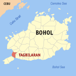
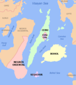
Bohol, officially the Province of Bohol, is an island province of the Philippines located in the Central Visayas region, consisting of the island itself and 75 minor surrounding islands. Its capital is Tagbilaran. With a land area of 4,821 km2 (1,861 sq mi) and a coastline 261 km (162 mi) long, Bohol is the tenth largest island of the Philippines.

<span class="mw-page-title-main">Baclayon</span> Municipality in Bohol, Philippines

Baclayon, officially the Municipality of Baclayon, is a 4th class municipality in the province of Bohol, Philippines. According to the 2020 census, it has a population of 22,461 people.

<span class="mw-page-title-main">Batuan, Bohol</span> Municipality in Bohol, Philippines

Batuan, officially the Municipality of Batuan, is a 5th class municipality in the province of Bohol, Philippines. According to the 2020 census, it has a population of 13,845 people.

<span class="mw-page-title-main">Bien Unido</span> Municipality in Bohol, Philippines

Bien Unido, officially the Municipality of Bien Unido, is a 4th class municipality in the province of Bohol, Philippines. According to the 2020 census, it has a population of 26,666 people.

<span class="mw-page-title-main">Bilar, Bohol</span> Municipality in Bohol, Philippines

Bilar, officially the Municipality of Bilar, is a 4th class municipality in the province of Bohol, Philippines. According to the 2020 census, it has a population of 18,512 people.

<span class="mw-page-title-main">Calape</span> Municipality in Bohol, Philippines

Calape, officially the Municipality of Calape, is a 3rd class municipality in the province of Bohol, Philippines. According to the 2020 census, it has a population of 33,079 people.

<span class="mw-page-title-main">Dauis</span> Municipality in Bohol, Philippines

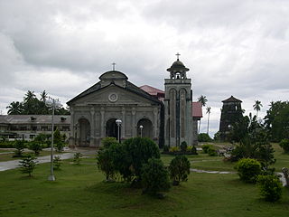
Dauis, officially the Municipality of Dauis, is a 4th class municipality in the province of Bohol, Philippines. According to the 2020 census, it has a population of 52,492 people. The town has many fine beaches, resorts, and a historic church, built in the 17th century. The Hinagdanan Cave is also a draw for tourists.

<span class="mw-page-title-main">Inabanga</span> Municipality in Bohol, Philippines

Inabanga, officially the Municipality of Inabanga, is a 3rd class municipality in the province of Bohol, Philippines. According to the 2020 census, it has a population of 48,534 people.

<span class="mw-page-title-main">Jagna</span> Municipality in Bohol, Philippines

Jagna, officially the Municipality of Jagna, is a 3rd class municipality in the province of Bohol, Philippines. According to the 2020 census, it has a population of 35,832 people.

<span class="mw-page-title-main">Loay, Bohol</span> Municipality in Bohol, Philippines

Loay, officially the Municipality of Loay, is a 5th class municipality in the province of Bohol, Philippines. According to the 2020 census, it has a population of 17,855 people.

<span class="mw-page-title-main">Loboc</span> Municipality in Bohol, Philippines

Loboc, officially the Municipality of Loboc, is a 4th class municipality in the province of Bohol, Philippines. According to the 2020 census, it has a population of 17,418 people.

<span class="mw-page-title-main">Loon, Bohol</span> Municipality in Bohol, Philippines

Loon, officially the Municipality of Loon, is a 2nd class municipality in the province of Bohol, Philippines which was established in 1753. According to the 2020 census, it has a population of 44,224 people.

<span class="mw-page-title-main">Panglao, Bohol</span> Municipality in Bohol, Philippines

Panglao, officially the Municipality of Panglao, is a 4th class municipality in the province of Bohol, Philippines. According to the 2020 census, it has a population of 39,839 people.

<span class="mw-page-title-main">San Isidro, Bohol</span> Municipality in Bohol, Philippines

San Isidro, officially the Municipality of San Isidro, is a 5th class municipality in the province of Bohol, Philippines. According to the 2020 census, it has a population of 9,909 people.

<span class="mw-page-title-main">Sierra Bullones</span> Municipality in Bohol, Philippines

Sierra Bullones, officially the Municipality of Sierra Bullones, is a third class municipality in the province of Bohol, Philippines. According to the 2020 census, it has a population of 26,095 people.

<span class="mw-page-title-main">Sikatuna, Bohol</span> Municipality in Bohol, Philippines

Sikatuna, officially the Municipality of Sikatuna, is a 5th class municipality in the province of Bohol, Philippines. According to the 2020 census, it has a population of 6,906 people.

<span class="mw-page-title-main">Tubigon</span> Municipality in Bohol, Philippines

Tubigon, officially the Municipality of Tubigon, is a 1st class municipality in the province of Bohol, Philippines. According to the 2020 census, it has a population of 47,886 people.

<span class="mw-page-title-main">Ubay, Bohol</span> Municipality in Bohol, Philippines

Ubay, officially the Municipality of Ubay, is a fast growing 1st class municipality in the province of Bohol, Philippines. Based on the 2020 Philippine Statistics Authority census, it has a population of 81,799 people which is projected to grow to 100,000 in 2030.

Datu Sikatuna was a Datu or chieftain of the Bool Kingdom in the island of Bohol in the Philippines. He made a blood compact (sanduguan) and alliance with the Spanish explorer Miguel López de Legazpi on March 25, 1565 at Hinawanan Bay, barangay Hinawanan, Loay. Their blood compact is the first Treaty of Friendship between Spain and the Philippines. The previous site of the pact was thought to have been at barangay Bool, Tagbilaran City but later a panel of historians concluded that the event actually happened at barangay Hinawanan, Loay, Bohol as ratified through Resolution No. 4, issued by the National Historical Institute in 2005.

<span class="mw-page-title-main">Panglao Island</span> Island in the province of Bohol in the Philippines

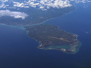
Panglao is an island in the north Bohol Sea, located in the Central Visayas region of the Visayas island group, in the south-central Philippines.

References

  1. City of Tagbilaran | (DILG)
  2. "2015 Census of Population, Report No. 3 – Population, Land Area, and Population Density" (PDF). Philippine Statistics Authority. Quezon City, Philippines. August 2016. ISSN   0117-1453. Archived (PDF) from the original on May 25, 2021. Retrieved July 16, 2021.
  3. 1 2 3 4 Census of Population (2020). "Region VII (Central Visayas)". Total Population by Province, City, Municipality and Barangay. Philippine Statistics Authority . Retrieved July 8, 2021.
  4. "PSA Releases the 2021 City and Municipal Level Poverty Estimates". Philippine Statistics Authority. April 2, 2024. Retrieved April 28, 2024.
  5. "Tagbiliran". Value Alliance. Retrieved January 30, 2019.
  6. "History".
  7. 1 2 Akpenodu & Saloma 2011.
  8. "Historical and Cultural Life of the Barrio of Tiptip". National Library of the Philippines Digital Library. Retrieved January 21, 2017.
  9. History of Tagbilaran Retrieved December 6, 2009.
  10. "The City of Tagbilaran Fast Facts". Philippine Daily Inquirer. July 1, 2005. Retrieved March 8, 2024.
  11. "Tagbilaran City, Bohol Climatological Normal Values". Philippine Atmospheric, Geophysical and Astronomical Services Administration. Archived from the original on October 18, 2018. Retrieved October 18, 2018.
  12. 1 2 Census of Population and Housing (2010). "Region VII (Central Visayas)" (PDF). Total Population by Province, City, Municipality and Barangay. National Statistics Office . Retrieved June 29, 2016.
  13. Census of Population (2015). "Region VII (Central Visayas)". Total Population by Province, City, Municipality and Barangay. Philippine Statistics Authority . Retrieved June 20, 2016.
  14. Censuses of Population (1903–2007). "Region VII (Central Visayas)". Table 1. Population Enumerated in Various Censuses by Province/Highly Urbanized City: 1903 to 2007. National Statistics Office.{{cite encyclopedia}}: CS1 maint: numeric names: authors list (link)
  15. "Poverty incidence (PI):". Philippine Statistics Authority. Retrieved December 28, 2020.
  16. "Estimation of Local Poverty in the Philippines" (PDF). Philippine Statistics Authority. November 29, 2005.
  17. "2003 City and Municipal Level Poverty Estimates" (PDF). Philippine Statistics Authority. March 23, 2009.
  18. "City and Municipal Level Poverty Estimates; 2006 and 2009" (PDF). Philippine Statistics Authority. August 3, 2012.
  19. "2012 Municipal and City Level Poverty Estimates" (PDF). Philippine Statistics Authority. May 31, 2016.
  20. "Municipal and City Level Small Area Poverty Estimates; 2009, 2012 and 2015". Philippine Statistics Authority. July 10, 2019.
  21. "PSA Releases the 2018 Municipal and City Level Poverty Estimates". Philippine Statistics Authority. December 15, 2021. Retrieved January 22, 2022.
  22. "PSA Releases the 2021 City and Municipal Level Poverty Estimates". Philippine Statistics Authority. April 2, 2024. Retrieved April 28, 2024.
  23. "Cebu to Bohol". GeckoRoutes. September 19, 2019. Retrieved October 4, 2019.
  24. Rey, Aika (November 27, 2018). "Duterte inaugurates Bohol-Panglao International Airport". Rappler. Retrieved October 4, 2019.
  25. Saldajeno, Ivan Stewart (January 23, 2022). "Mark Magsayo wins WBC featherweight title". Philippine News Agency. Retrieved January 2, 2023.
  26. Waters, Luke (September 25, 2015). "Aussie trainer helps revive Filipino boxer's title dream". SBS News. Retrieved January 2, 2023.

Sources