
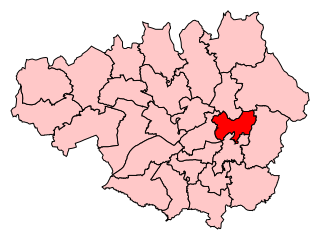
The Metropolitan Borough of Tameside is a metropolitan borough of Greater Manchester in England. It is named after the River Tame, which flows through the borough, and includes the towns of Ashton-under-Lyne, Audenshaw, Denton, Droylsden, Dukinfield, Hyde, Mossley and Stalybridge. Its western border is approximately 4 miles (6.4 km) east of Manchester city centre. Tameside is bordered by the metropolitan boroughs of Stockport and Oldham to the south and north respectively, the city of Manchester to the west and the borough of High Peak in Derbyshire to the east across Longdendale. As of 2011 the overall population was 219,324. It is also the 8th-most populous borough of Greater Manchester by population.
Denton is a town in Tameside, Greater Manchester, England, five miles (8 km) east of Manchester city centre. Historically part of Lancashire, it had a population of 36,591 at the 2011 Census.

Ashton-under-Lyne is a market town in Tameside, Greater Manchester, England. The population was 45,198 at the 2011 census. Historically in Lancashire, it is on the north bank of the River Tame, in the foothills of the Pennines, 6.2 miles (10.0 km) east of Manchester.

Dukinfield is a town in Tameside, Greater Manchester, England, on the south bank of the River Tame opposite Ashton-under-Lyne, 6.3 miles (10.1 km) east of Manchester. At the 2011 Census, it had a population of 19,306.

Hyde is a town in Tameside, Greater Manchester, England, which had a population of 34,003 in 2011.

Audenshaw is a market town in Tameside, Greater Manchester, England, 4.9 miles (7.9 km) east of Manchester. Historically part of Lancashire, in 2011 it had a population of 11,419.

Mossley (/ˈmɒzli/) is a town and civil parish in Tameside, Greater Manchester, England, in the upper Tame Valley and the foothills of the Pennines, 3 miles (4.8 km) southeast of Oldham and 8.9 miles (14.3 km) east of Manchester.

Droylsden is a town in Tameside, Greater Manchester, England, 4.1 miles (6.6 km) east of Manchester city centre and 2.2 miles (3.5 km) west of Ashton-under-Lyne, with a population at the 2011 Census of 22,689.
Ashton-under-Lyne is a constituency in the House of Commons of the UK Parliament. It has been represented since 2015 by Angela Rayner, who has served as Deputy Leader of the Labour Party since 2020.

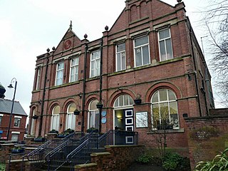
Tameside Hippodrome is a 1400 seater theatre located in Ashton-under-Lyne, Greater Manchester, England.
Openshaw is a suburb of Manchester, England, about three miles east of the city centre. Historically part of Lancashire, Openshaw was incorporated into the city of Manchester in 1890. Its name derives from the Old English Opinschawe, which means an open wood or coppice.
Tameside and Glossop Integrated Care NHS Foundation Trust is an integrated foundation Trust that operates from Tameside General Hospital situated in Ashton-under-Lyne. It serves the surrounding area of Tameside in Greater Manchester, and the town of Glossop and other smaller towns and villages in the north western part of the High Peak district of Derbyshire. Employing approximately 3,800 staff, the Trust provides a range of services both within the hospital and in the local community. This includes Accident and Emergency services, and full consultant-led obstetric and paediatric hospital services for women, children and babies.
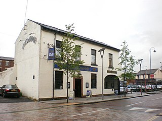
The Witchwood is a pub and live music venue in Ashton-under-Lyne, Greater Manchester, England. Located in Ashton's town centre, The Witchwood has been a hub for live indie and rock music since the 1960s, and features on North West England's pub music circuit.
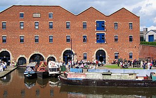
Dukinfield Junction is the name of the canal junction where the Peak Forest Canal, the Ashton Canal and the Huddersfield Narrow Canal meet near Ashton-under-Lyne, Greater Manchester, England. The area has been designated by Tameside Metropolitan Borough Council as a conservation area.

Droylsden is a tram stop on the East Manchester Line (EML) of Greater Manchester's light-rail Metrolink system. It opened on 11 February 2013, after a three-day free trial for local residents. The stop was constructed as part of Phase 3a of the Metrolink's expansion, and is located in Droylsden town centre, a part of Tameside, England.
Ashton Sixth Form College is an 'Outstanding' sixth form college in Ashton-under-Lyne, Greater Manchester. Founded in 1928 as Ashton-under-Lyne Grammar School, the college has an acceptance rate of 28% (2021).

Ashton-under-Lyne bus station is a bus station that is located in the town of Ashton-under-Lyne in Greater Manchester, run by Transport for Greater Manchester. The bus station is situated on Wellington Road and adjoins the Arcades Shopping Centre. The bus station was opened in 2020 and replaced the previous bus station that was built on the current site.
Ashton Ladysmith Cricket Club are an open age English cricket team, based in the town of Ashton-under-Lyne in Tameside, Greater Manchester. The club plays its home games at the Ladysmith Sports Centre on Rose Hill Road, and competes in the North Manchester Cricket League. The club was formerly known as Ashton St. James Cricket Club and played their games on St Albans Avenue in Ashton-under-Lyne.

The East Manchester Line (EML) is a tram line of the Manchester Metrolink in Greater Manchester, England, running from Manchester to Ashton-under-Lyne via Droylsden and Audenshaw. The line opened in 2013 as part of phase three of the system's expansion.
