
North Sulawesi is a province of Indonesia. It is located on the Minahasa Peninsula of Sulawesi, south of the Philippines and southeast of Sabah, Malaysia. It borders Davao and Soccsksargen regions of the Philippines to the north, the Maluku Sea to the east, Gorontalo and Celebes Sea to the west and the Gulf of Tomini to the southwest. With Miangas, it is the northernmost province of Indonesia. The province's area is 13,892.47 square kilometres (5,363.91 sq mi), and its population was 2,270,596 according to the 2010 census; this rose to 2,621,923 at the 2020 Census.

The Riau Islands is a province of Indonesia. It comprises a total of 1,796 islands scattered between Sumatra, Malay Peninsula, and Borneo including the Riau Archipelago. Situated on one of the world's busiest shipping lanes along the Malacca Strait and the South China Sea, the province shares water borders with neighboring countries such as Singapore, Malaysia, and Brunei. The Riau Islands also has a relatively large potential of mineral resources, energy, as well as marine resources. The capital of the province is Tanjung Pinang and the largest city is Batam.
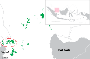
The Riau Archipelago is a geographic term for the core group of islands within the Riau Islands Province in Indonesia, and located south of Singapore and east of Riau on Sumatra. Before the province of Riau Islands was formed, there was no ambiguity in term; however, in Indonesian language, both the archipelago and administrative province are referred to as simply "Kepulauan Riau". The province may have the word "Provinsi" preceding it for clarity. Additionally the term BBK for Batam Bintan Karimun may refer to the archipelago.

Batam is the largest city in the province of Riau Islands, Indonesia. The city administrative area covers three main islands of Batam, Rempang, and Galang, as well as several small islands. Batam Island is the core urban and industrial zone, while both Rempang Island and Galang Island maintain their rural character and are connected to Batam Island by short bridges. Batam is an industrial boomtown, an emerging transport hub, and part of a free trade zone in the Indonesia–Malaysia–Singapore Growth Triangle, located 20 km (12 mi) off Singapore's south coast and also part of the Indonesia–Malaysia–Thailand Growth Triangle.

Belitung is an island on the east coast of Sumatra, Indonesia in the Java Sea. It covers 4,800.6 km2 (1,853.5 sq mi), and had a population of 271,869 in 2014. Administratively, it forms part of the province of Bangka-Belitung Islands. The island is known for its pepper and for its tin. It was in the possession of the United Kingdom from 1812 until Britain ceded control of the island to the Netherlands in the Anglo-Dutch Treaty of 1824. Its main town is Tanjung Pandan. The United Nations Educational, Scientific and Cultural Organization has declared 17 tourist attractions in the Belitung Geopark as world geoparks.

Bintan Island or Negeri Segantang Lada is an island in the Riau archipelago of Indonesia. It is part of the Riau Islands province, the capital of which, Tanjung Pinang, lies in the island's south and is the island's main community.

Great Karimun Island or Nuwi Island is one of the islands in the Riau Islands province of Indonesia, administratively part of Karimun Regency. It lies about 37 km southwest of Singapore, 54 km west of Batam, 24 km northeast of Rangsang Island and 32 km north of Kundur Island.

The Lingga Regency is a group of islands in Indonesia, located south of Singapore, along both sides of the equator, off the eastern coast of Riau Province on Sumatra island. They are south of the populated Riau Archipelago, known for the industrial island of Batam and the tourist-frequented island of Bintan, although the Lingga Islands themselves are rarely visited due to the infrequent local transportation. The equator goes through the northern tip of Lingga Island, the main island in the archipelago.

Tanjungpinang, also written as Tanjung Pinang, is the capital city of the Indonesian province of Riau Islands. It covers a land area of 144.56 km2, mainly on the southern Bintan Island, as well as other smaller islands such as Dompak Island and Penyengat Island. With a population of 227,663 at the 2020 Census, it is the second largest city of the province, after Batam. Tanjungpinang is a historic city of the Malay culture, having served as the capital of both Johor Sultanate and Riau-Lingga Sultanate.
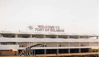
Belawan is a harbor in Medan, North Sumatra. Located on the northeast coast of Sumatra, Belawan is Indonesia's busiest seaport outside of Java. It constitutes the most northerly of the city of Medan's 21 administrative districts (kecamatan), and covers an area of 29.44 km2; at the 2010 Census it had a population of 95,506.

The Singapore Cruise Centre is a cruise terminal located in the south of Singapore next to HarbourFront Centre in the vicinity of HarbourFront and in Keppel Harbour, near HarbourFront MRT station.
Pandeglang Regency is a regency of Banten province, Indonesia. It is mainly located on the west and south coasts of the island of Java, and is the most westerly regency on Java Island, but it also includes a number of offshore islands such as Panaitan, Deli and Tinjil. The regency has an area of 2,746.81 km2, and an population at the 2010 Census of 1,149,610, rising to 1,272,687 at the 2020 Census. The regency seat is the town of Pandeglang.

Tanjungbalai, formerly known as Tanjungbalai-Asahan is a city in North Sumatra province, Indonesia, on the estuary of the Asahan River. It has an area of 60.52 square kilometers (23.37 sq mi) and the sixth largest kota (urban) population in North Sumatra with 154,445 inhabitants in the 2010 census and 176,027 at the 2020 Census. The town has a ferry terminal with services to Port Klang, Malaysia, and the city-island of Singapore.

Rokan Hilir is a regency (kabupaten) of Riau Province, on Sumatra island, Indonesia. It occupies the lower part of the catchment area of the Rokan River, and has an area of 8,851.59 km². It had a population of 553,216 at the 2010 Census and 637,161 at the 2020 Census. The administrative centre of the Rokan Hilir Regency is located at Bagansiapiapi.

The Indonesia–Malaysia border consists of a 1,881 km land border that divides the territory of Indonesia and Malaysia on the island of Borneo. It also includes maritime boundaries along the length of the Straits of Malacca, in the South China Sea and in the Celebes Sea.

The Karimun Regency is located in the Riau Islands Province, Indonesia. Besides the central island of Great Karimun, the regency also includes the islands of Kundur and over 240 smaller islands. The district covers a land area of 1,524 km2 and a sea area of 6,460 km2, and its population was 212,561 at the 2010 Census and 253,457 at the 2020 Census.
Selat Panjang is the capital of Kepulauan Meranti Regency, which is part of the province of Riau in Indonesia. The regency is a new regency in Riau province which was established in 2009 after being separated from Bengkalis Regency. The city is located on Tebing Tinggi Island, which is separated by a narrow channel from Sumatra, and across the Strait of Malacca from Singapore.

West Lombok Regency is a regency of the Indonesian Province of West Nusa Tenggara. It is located on the island of Lombok and the administrative capital is the town of Gerung. The regency covers an area of 1,053.92 km2 and had a population of 599,609 at the 2010 Census and 721,481 at the 2020 Census.
Tanjung Balai or Tanjungbalai may refer to:

Kundur Island is an island within the Riau Archipelago, part of the Riau Islands Province of Indonesia. It lies at about 80 kilometres southwest of Singapore, 76 kilometres (47 mi) southwest of Batam, 32 kilometres (20 mi) south of Great Karimun Island, 172 kilometres (107 mi) northwest of Lingga Islands and 120 kilometres (75 mi) west of Tanjung Pinang. It has an area of about 304 square kilometres (117 sq mi), not including Buru District. According to the 2010 Census population, the population of Kundur Island was 67,090. As Kundur does not have an airport, all visitors arrive by ferry.


