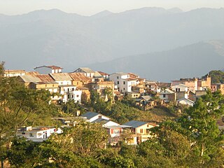
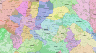
Dhankuta is a hill town and the headquarters of Dhankuta District in Koshi Province in Eastern Nepal. According to 2011 Nepal census, it has population of 26,440 inhabitants.

Bhaktapur District (Nepali: भक्तपुर जिल्ला; Nepal Bhasa : ख्वप देश located in the eastern part of Kathmandu valley, is the smallest among Nepal's 77 districts. It is part of Bagmati Province. Bhaktapur District Post Office is 44800. The district, with Bhaktapur as its district headquarters, covers an area of 119 km2 and in 2011 had a population of 304,651 of whom 9,701 people were absent.

Lalitpur District (Nepali: ललितपुर जिल्ला, in Bagmati Province, is one of the seventy-seven districts of Nepal. The district, with Lalitpur as its district headquarters, covers an area of 396.92 km2 and has a population of 337,785. It is one of three districts in the Kathmandu Valley, along with Kathmandu and Bhaktapur. Its population was 466,784 in the initial 2011 census tabulation. It is surrounded by Makwanpur, Bhaktapur, Kathmandu and Kavre.

Khandbari is the district headquarters of Sankhuwasabha District in Koshi Province of north-eastern Nepal.

Gorkha is a municipality in Gorkha District in Gandaki Province of Nepal created in 1996. It was initially named "Prithibinarayan" after King Prithvi Narayan Shah, who was born in Gorkha and united and founded modern Nepal. In 2009, the name was changed to "Gorkha" municipality after the end of the monarchy in Nepal. At the time of the 2021 Nepal census it had a population of 53,285 people living in 12,641 individual households. In 2014, the neighboring Village development committees Nareshwar and Phinam were merged into the municipality.
Myanglung is a municipality and the district headquarters of Terhathum District of Koshi Province in eastern Nepal. The municipality is situated at an elevation of about 1500 metres above sea level. Myanglung was converted into a municipality from a village development committee on 18 May 2014, merging the existing village development committees of Myanglung, Piple, Jirikhimti, Ambung, Sabla and Tamphula. According to the census of 2011 the total population of Myanglung is 19,659 including five VDCs.
Chainpur is a municipality in Sankhuwasabha District in the Koshi Province of north-eastern Nepal. It was formed by merging five villages i.e. Chainpur, Siddhakali, Siddhapokhari, Baneshwar and Kharang. The municipality was implemented on 18 May 2014. At the time of the 1991 Nepal census it had a population of 4933 people in 948 households.

Pakhribas is an urban municipality out of three urban municipalities located in Dhankuta District of Province No. 1 of Nepal. Pakhribas municipality established on 2 December 2014 merging following VDCs: Pakhribas, Sanne, Phalate, Ghorlikharka and Muga.
Godawari is a municipality in Lalitpur District in Bagmati Province of Nepal. It was established on 2 December 2014 by merging the former Village development committees Godawari, Badikhel, Bisankhunarayan, Godamchaur and Thaiba of Lalitpur District of Bagmati Zone. The municipality area was again expanded in March 2017 to include in total 12 previous VDCs. The six VDCs added were Devichaur, Dukuchhap, Chhampi, Thecho, Chapagaun, Jharuwarasi and Lele. The centre of this municipality is located at Bajrabarahi.
Nagarjun is a municipality in Kathmandu District in Bagmati Province of Nepal. It was formed on 2 December 2014 by merging the former VDCs of Bhimdhunga, Ichangu Narayan, Ramkot, Syuchatar and Sitapaila. The office of the municipality is located at Harisiddhi, Sitapaila. There are ten wards in the municipality.
Shankharapur is a municipality in Kathmandu District in Bagmati Province of Nepal that was established on 2 December 2014 by merging the former Village development committees Bajrayogini, Karkigaun, Bhulbu, Indrayani, Lapsiphedi, Naglebhare, Pukhulachhi and Suntol. The office of the municipality is that of the former Pukhulachhi village development committee in the old Newari town of Sankhu.

Laligurans is a municipality located in Terhathum District in the Koshi Province of eastern Nepal. After the government announcement, the municipality was established on 19 September 2015 by merging the existing Basantapur, Phulek, Dangpa, Sungnam and Solma village development committees (VDCs). The center of the municipality is established in Basantpur. At the time of the 2011 Nepal census after merging the five VDCs population it had a total population of 16,934 persons. After the government decision the number of municipalities has reached 217 in Nepal.
Mahalaxmi is a municipality that lies in the north-eastern part of the Lalitpur district of Nepal. As per the declaration by the government of Nepal in 2015, it was created through the merger of the Village development committees Imadol, Lubhu, Tikathali, Siddhipur and Lamatar. The city derives its name from the Mahalaxmi-Mahabhairav Temple in Lubhu. The city's total area is 26.5 square kilometres. The municipality has a total number of 10 wards. The old VDC offices are used as joint ward office now.
Panchkhapan (Nepali: पाँचखप्पन) is an urban municipality out of five urban municipalities of Sankhuwasabha District in Koshi Province of Nepal. It lies on 87°12'12" E to 87°26'45" E Longitude and 27°17'37.4" N to 27°24'38" N Latitude. The municipality was established on 3 March 2017 merging former VDCs: Syabun, Jaljala and Wana. The area of the municipality is 148.03KM2 and according to 2011 census of Nepal the population of the municipality is 17,521.
Dharmadevi is a municipality in Sankhuwasabha District of Koshi Province in Nepal. It is a municipality out of 5 municipalities in Sankhuwasabha District. Total area of the municipality is 133 km (83 mi) and according to 2011 census of Nepal, the population of this municipality is 18,235. The municipality was established in March 2017 merging some former VDCs: e.g. Aankhibhui, Mamling and Tamaphok. The municipality is divided into 9 wards. The headquarter of the municipality is in Tamaphok.
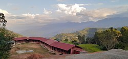
Mahalaxmi is a municipality in Dhankuta District of Koshi Province in Nepal. It is a municipality out of three urban municipalities in Dhankuta District. Total area of the municipality is 126.3 km (78.5 mi) and according to 2011 census of Nepal, the population of this municipality is 24,800. The municipality is divided into nine wards. The headquarter of the municipality is in Jitpur Bazar.
Buddhashanti is a rural municipality (gaunpalika) out of seven rural municipality located in Jhapa District of Koshi Province of Nepal. Buddhashanti, according to Ministry of Federal Affairs and Local Development has an area of 79.78 square kilometres (30.80 sq mi) and the total population of the municipality is 41,615 as of Census of Nepal 2011.
Makalu is a rural municipality (gaunpalika) out of five rural municipality located in Sankhuwasabha District of Koshi Province of Nepal. There are a total of 10 municipalities in Sankhuwasabha in which 5 are urban and 5 are rural.
Gharapjhong Rural Municipality (Gharapjhong Gaupalika) (Nepali: घरपझोङ गाउँपालिका) is a Gaunpalika, or rural municipality, in Mustang district in Gandaki Province of Nepal. On 12 March 2017, the government of Nepal implemented a new local administrative structure, in which Village Development Committees were replaced with municipal and Village Councils. Gharapjhong is one of these 753 local units.
Benighat Rorang is a rural municipality located within the Dhading District of the Bagmati Province of Nepal. The rural municipality spans 29.17 square kilometres (11.26 sq mi), with a total population of 31,475 according to a 2011 Nepal census.