This article is part of a series on |
Administrative divisions of Nepal |
---|
Federal Democratic Republic of Nepal (since 2015) |
Nepal Portal Administrative divisions by country |
Municipality | |
---|---|
Kathmandu, the largest city (Metro city) | |
Category | Municipality |
Location | Nepal |
Created |
|
Number | 6 Metro City 11 Sub-metro city 276 Urban Municipality (as of 20 September 2015) |
Populations | 845,767 - 8,370 |
Areas | 547.43 square kilometres (211.36 sq mi) - 6.89 square kilometres (2.66 sq mi) |
Government | |
Subdivisions |
|
List of Gaupalikas of Nepal |
---|
(alternative subdivision) |
Cities and towns in Nepal are incorporated under municipality. A municipality in Nepal is a sub-unit of a district. The Government of Nepal has set-out a minimum criteria for municipalities. These criteria include a certain population, infrastructure and revenues. Presently, there are 293 municipalities in Nepal among which 6 are metropolis, 11 are sub-metropolis and 276 are municipal councils. Other than that there are 460 rural municipalities totaling 753 local level government within Nepal. [1]
Kathmandu, the capital, is also the largest city. [2] [3] In terms of area, Pokhara is the largest metropolitan city covering a subtotal of 464.28 km2 [4] while Lalitpur is the smallest, with an area of 36.12 km2. Ghorahi is the largest sub-metropolitan city with an area of 522.21 km2 where as Dhangadhi is the largest sub-metropolitan city by a population of 204,788. Budhanilkantha with a population of 179,688 is the largest municipality followed by Birendranagar with a population of 154,886. In terms of area, Sitganga is the largest municipality with an area of 610.43 square kilometres (235.69 sq mi). [5]
Along with other major criteria as mentioned in Local Governance Act 2017 of Nepal, the number of population to be considered as the municipality: the minimum population in mountainous district should be 10,000 while hilly districts, inner terai districts, terai districts, and Kathmandu valley should include forty thousand, fifty thousand, seventy thousand and one hundred thousand respectively. For sub-metropolitan, the population should be two hundred thousand, and it should be five hundred thousand for metropolitan. [6]
The list includes the cities and not urban agglomerations.
Classification:
The Ministry of Federal Affairs and General Administration has classified the local units into four grades based on infrastructure and social development. [7] [8]
Classification | Type | Quantity | |
---|---|---|---|
Grade 'A' | Very remote | 18 | |
Grade 'B' | Remote | 43 | |
Grade 'C' | Fairly accessible | 133 | |
Grade 'D' | Accessible | 99 |
The cities listed in bold are the capitals of their respective provinces of Nepal while that in bold and italic is the country capital.
Name | Nepali | District | Province | Population (2021) | Area (km2) | Density (/km2) | Website |
---|---|---|---|---|---|---|---|
Kathmandu | काठमाडौँ | Kathmandu | Bagmati | 845,767 | 49.45 | 17,103 | |
Pokhara | पोखरा | Kaski | Gandaki | 599,504 | 464.24 | 1,117 | |
Bharatpur | भरतपुर | Chitwan | Bagmati | 369,377 | 432.95 | 853 | |
Lalitpur | ललितपुर | Lalitpur | Bagmati | 299,843 | 36.12 | 8,301 | |
Birgunj | वीरगञ्ज | Parsa | Madhesh | 268,273 | 132.07 [9] | 2,031 | |
Biratnagar | विराटनगर | Morang | Koshi Pradesh | 244,750 | 77.00 [9] | 3,179 | |
Name | Nepali | District | Province | Population (2021) | Area | Density | Website |
---|---|---|---|---|---|---|---|
Dhangadhi | धनगढी | Kailali | Sudurpashchim | 204,788 | 261.75 | 782 | |
Ghorahi | घोराही | Dang | Lumbini | 201,079 | 522.21 | 385 | |
Itahari | इटहरी | Sunsari | Koshi Pradesh | 198,098 | 93.78 | 2,112 | |
Hetauda | हेटौडा | Makawanpur | Bagmati | 195,951 | 261.59 | 749 | |
Janakpurdham | जनकपुर | Dhanusha | Madhesh | 195,438 | 91.97 | 2,125 | |
Butwal | बुटवल | Rupandehi | Lumbini | 195,054 | 101.61 | 1,920 | |
Tulsipur | तुल्सिपुर | Dang | Lumbini | 180,734 | 384.63 | 470 | |
Dharan | धरान | Sunsari | Koshi Pradesh | 173,096 | 192.32 | 900 | |
Nepalgunj | नेपालगञ्ज | Banke | Lumbini | 166,258 | 85.94 | 1,935 | |
Kalaiya | कलैया | Bara | Madhesh | 141,179 | 108.94 | 1,296 | |
Jitpursimara | जीतपुरसिमरा | Bara | Madhesh | 119,148 | 312.18 | 382 |
Name | Nepali | District | Province | Population (2021) | Area | Density | Website |
---|---|---|---|---|---|---|---|
Budhanilkantha | बुढानिलकण्ठ | Kathmandu | Bagmati | 179,688 | 34.8 | 5,163 | |
Birendranagar | वीरेन्द्रनगर | Surkhet | Karnali | 154,886 | 245.06 | 632 | |
Tarakeshwar | तारकेश्वर | Kathmandu | Bagmati | 151,508 | 54.95 | 2,757 | |
Gokarneshwar | गोकर्णेश्वर | Kathmandu | Bagmati | 151,200 | 58.5 | 2,585 |
Name | Nepali | District | Province | Population (2021) | Area | Website |
---|---|---|---|---|---|---|
Tilottama | तिलोत्तमा | Rupandehi | Lumbini | 149,657 | 126.19 | |
Suryabinayak | सूर्यविनायक | Bhaktapur | Bagmati | 137,971 | 42.45 | |
Chandragiri | चन्द्रागिरी | Kathmandu | Bagmati | 136,928 | 43.9 | |
Tokha | टोखा | Kathmandu | Bagmati | 135,741 | 17.11 | |
Kageshwari-Manohara | कागेश्वरी मनोहरा | Kathmandu | Bagmati | 133,327 | 27.38 | |
Mechinagar | मेचीनगर | Jhapa | Koshi Pradesh | 131,520 | 192.85 | |
Bhimdatta | भीमदत्त | Kanchanpur | Sudurpashchim | 123,316 | 78.24 | |
Sundar Haraincha | सुन्दरहरैंचा | Morang | Koshi Pradesh | 121,305 | 110.16 | |
Madhyapur Thimi | मध्यपुर थिमी | Bhaktapur | Bagmati | 119,955 | 11.47 | |
Mahalaxmi | महालक्ष्मी | Lalitpur | Bagmati | 118,710 | 26.51 | |
Birtamod | बिर्तामोड | Jhapa | Koshi Pradesh | 117,355 | 78.24 | |
Nagarjun | नागार्जुन | Kathmandu | Bagmati | 115,507 | 29.85 | |
Damak | दमक | Jhapa | Koshi Pradesh | 107,410 | 70.86 | |
Triyuga | त्रियुगा | Udayapur | Koshi Pradesh | 104,375 | 547.43 | |
Lahan | लहान | Siraha | Madhesh | 102,955 | 167.17 | |
Godawari | गोदावरी | Lalitpur | Bagmati | 100,972 | 96.11 | |
Kohalpur | कोहलपुर | Banke | Lumbini | 100,289 | 184.26 |
Name | Nepali | District | Province | Population (2011) | Area | Website |
---|---|---|---|---|---|---|
Tikapur | टिकापुर | Kailali | Sudurpashchim | 90,115 | 121.92 | |
Siraha | सिरहा | Siraha | Madhesh | 82,531 | 94.2 | |
Bhaktapur | भक्तपुर | Bhaktapur | Bagmati | 81,728 | 6.89 | |
Godawari | गोदावरी | Kailali | Sudurpashchim | 78,018 | 305.63 | |
Barahachhetra | बराहक्षेत्र | Sunsari | Koshi Pradesh | 77,408 | 222.09 | |
Kapilvastu | कपिलवस्तु | Kapilvastu | Lumbini | 76,394 | 136.91 | |
Lamki Chuha | लम्की चुहा | Kailali | Sudurpashchim | 90,941 | 225 | |
Bardaghat | बर्दघाट | Nawalparasi West | Lumbini | 76,703 | 162.05 | [8] |
Ghodaghodi | घोडाघोडी | Kailali | Sudurpashchim | 75,586 | 354.45 | |
Banganga | बाणगंगा | Kapilvastu | Lumbini | 75,242 | 233.68 |
The list includes the cities and not urban agglomerations. The list includes the cities with 100,000+ population.
Definition: The Ministry of Federal Affairs and General Administration has classified the local units into four grades based on infrastructure and social development: [7] [8]
The cities listed in bold are the capitals of their respective provinces of Nepal while that in bold and italic is the country capital.
City | Population (2021) [11] | Population (2011) [12] | Change (%) | Area (km2) | Density (/km2) | District | Province |
---|---|---|---|---|---|---|---|
Kathmandu | 845,767 | 975,453 | −13.29% | 49.45 | 17,103 | Kathmandu | Bagmati |
Pokhara | 518,452 | 255,465 | +102.94% | 464.28 | 1,117 | Kaski | Gandaki |
Bharatpur | 369,377 | 143,836 | +156.80% | 432.95 | 853 | Chitwan | Bagmati |
Lalitpur | 299,843 | 220,802 | +35.80% | 36.12 | 8,301 | Lalitpur | Bagmati |
Birgunj | 268,273 | 135,904 | +97.40% | 132.07 | 2,031 | Parsa | Madhesh |
Biratnagar | 244,750 | 201,125 | +21.69% | 77.00 | 3,179 | Morang | Koshi Pradesh |
Dhangadhi | 204,788 | 101,970 | +100.83% | 261.75 | 782 | Kailali | Sudurpashchim |
Ghorahi | 201,079 | 62,928 | +219.54% | 522.21 | 385 | Dang | Lumbini |
Itahari | 198,098 | 74,501 | +165.90% | 93.78 | 2,112 | Sunsari | Koshi Pradesh |
Hetauda | 195,951 | 84,671 | +131.43% | 261.59 | 749 | Makawanpur | Bagmati |
Janakpur | 195,438 | 97,776 | +99.88% | 91.97 | 2,125 | Dhanusha | Madhesh |
Butwal | 195,054 | 118,462 | +64.66% | 101.61 | 1,920 | Rupandehi | Lumbini |
Tulsipur | 180,734 | 51,537 | +250.69% | 384.63 | 470 | Dang | Lumbini |
Budhanilkantha | 179,688 | 107,918 | +66.50% | 34.8 | 5,163 | Kathmandu | Bagmati |
Dharan | 173,096 | 116,181 | +48.99% | 192.32 | 900 | Sunsari | Koshi Pradesh |
Nepalgunj | 166,258 | 72,503 | +129.31% | 85.94 | 1,935 | Banke | Lumbini |
Birendranagar | 154,886 | 47,914 | +223.26% | 245.06 | 632 | Surkhet | Karnali |
Tarakeshwar | 151,508 | 81,443 | +86.03% | 54.95 | 2,757 | Kathmandu | Bagmati |
Gokarneshwar | 151,200 | 107,351 | +40.85% | 58.5 | 2,585 | Kathmandu | Bagmati |
Tilottama | 149,657 | 100,149 | +49.43% | 126.19 | 1,186 | Rupandehi | Lumbini |
Kalaiya | 141,179 | 42,826 | +229.66% | 108.94 | 1,296 | Bara | Madhesh |
Suryabinayak | 137,971 | 78,490 | +75.78% | 42.45 | 3,250 | Bhaktapur | Bagmati |
Chandragiri | 136,928 | 85,195 | +60.72% | 43.9 | 3,119 | Kathmandu | Bagmati |
Tokha | 135,741 | 99,032 | +37.07% | 17.11 | 7,933 | Kathmandu | Bagmati |
Kageshwari-Manohara | 133,327 | 60,237 | +121.34% | 27.38 | 4,870 | Kathmandu | Bagmati |
Mechinagar | 131,520 | 57,545 | +128.55% | 192.85 | 682 | Jhapa | Koshi Pradesh |
Bhimdatta | 123,316 | 104,599 | +17.89% | 78.24 | 1,576 | Kanchanpur | Sudurpashchim |
Sundar Haraincha | 121,305 | 80,518 | +50.66% | 110.16 | 1,101 | Morang | Koshi Pradesh |
Thimi | 119,955 | 83,036 | +44.46% | 11.47 | 10,458 | Bhaktapur | Bagmati |
Jitpursimara | 119,148 | 117,094 | +1.75% | 312.18 | 382 | Bara | Madhesh |
Mahalaxmi | 118,710 | 62,172 | +90.94% | 26.51 | 4,478 | Lalitpur | Bagmati |
Birtamod | 117,355 | 81,878 | +43.33% | 78.24 | 1,500 | Jhapa | Koshi Pradesh |
Nagarjun | 115,507 | 67,420 | +71.32% | 29.85 | 3,870 | Kathmandu | Bagmati |
Damak | 107,410 | 75,102 | +43.02% | 70.86 | 1,516 | Jhapa | Koshi Pradesh |
Triyuga | 104,375 | 70,000 | +49.11% | 547.43 | 191 | Udayapur | Koshi Pradesh |
Lahan | 102,955 | 33,653 | +205.93% | 167.17 | 616 | Siraha | Madhesh |
Godawari | 100,972 | 78,301 | +28.95% | 96.11 | 1,051 | Lalitpur | Bagmati |
Kohalpur | 100,289 | 36,019 | +178.43% | 184.26 | 544 | Banke | Lumbini |
The list includes the Metropolitan Areas which includes multiple cities and urban municipalities. The list of Metropolitan Area includes 300,000+ population.
The list includes then existing municipalities as enumerated by the Central Bureau of Statistics (Nepal). The list includes the cities and not urban agglomerations.
The list of cities by population based on 1991 Nepal census are: [16] [17]
City | Population (1991 Nepal census) | Households | Development region |
---|---|---|---|
Kathmandu | 421,258 | 81,139 | Central |
Biratnagar | 129,388 | 24,043 | Eastern |
Lalitpur | 115,865 | 20,630 | Central |
Pokhara | 95,286 | 20,273 | Western |
Birgunj | 69,005 | 11,084 | Central |
Dharan | 66,457 | 12,549 | Eastern |
Mahendranagar | 62,050 | 9,875 | Far-Western |
Bhaktapur | 61,405 | 9,187 | Central |
Janakpur | 54,710 | 9,668 | Central |
Bharatpur | 54,670 | 10,918 | Central |
The list of cities by population based on 2001 Nepal census are: [18]
The list includes cities with more than 35,000 population.
City | Population (2001 Nepal census) | Area (km2) | Density (/km2) | Households | Development region |
---|---|---|---|---|---|
Kathmandu | 671,846 | 49.45 | 13586.37 | 152,155 | Central |
Biratnagar | 166,674 | 58.48 | 2850.10 | 33,678 | Eastern |
Lalitpur | 162,991 | 15.15 | 10758.48 | 34,996 | Central |
Pokhara | 156,312 | 55.22 | 2830.71 | 37,305 | Western |
Birgunj | 112,484 | 21.17 | 5313.37 | 19,910 | Central |
Dharan | 95,332 | 103.38 | 922.15 | 20,428 | Eastern |
Bharatpur | 89,323 | 162.16 | 550.83 | 19,922 | Central |
Mahendranagar | 80,839 | 171.24 | 472.08 | 13,738 | Far-Western |
Butwal | 75,384 | 69.28 | 1088.11 | 16,281 | Western |
Janakpur | 74,192 | 24.61 | 3014.71 | 13,734 | Central |
Bhaktapur | 72,543 | 6.56 | 11,058.38 | 12,133 | Central |
Hetauda | 68,482 | 47.77 | 1,433.58 | 14,271 | Central |
Dhangadhi | 67,447 | 103.73 | 650.22 | 11,738 | Far-Western |
Nepalgunj | 57,535 | 12.51 | 4,599.12 | 10,592 | Mid-Western |
Triyuga | 55,291 | 319.88 | 172.85 | 10,506 | Eastern |
Siddharthanagar | 52,569 | 36.03 | 1,459.03 | 9,419 | Western |
Mechinagar | 49,060 | 55.72 | 880.47 | 9,926 | Eastern |
Madhyapur Thimi | 47,751 | 11.11 | 4,298.02 | 9,551 | Central |
Gulariya | 46,011 | 95.14 | 483.61 | 7,939 | Mid-Western |
Tribhuvan Nagar (Ghorahi) | 43,126 | 74.45 | 579.26 | 8,945 | Mid-Western |
Lekhnath | 41,369 | 77.45 | 534.14 | 9,362 | Western |
Itahari | 41,210 | 42.37 | 972.62 | 8,624 | Eastern |
Kirtipur | 40,835 | 14.76 | 2,766.60 | 9,487 | Central |
Tikapur | 38,722 | 67.11 | 576.99 | 6,287 | Far-Western |
Ratnanagar | 37,791 | 35.62 | 1,060.95 | 7,456 | Central |
Damak | 35,009 | 70.63 | 495.67 | 7,178 | Eastern |
The list of cities by population based on 2011 Nepal census are: [19]
The list includes cities with more than 40,000 population.
City | Population (2011 Nepal census) | Households | Development region |
---|---|---|---|
Kathmandu | 975,453 | 254,292 | Central |
Pokhara | 255,465 | 68,236 | Western |
Lalitpur | 220,802 | 54,581 | Central |
Biratnagar | 201,125 | 45,131 | Eastern |
Birgunj | 135,904 | 24,164 | Central |
Butwal | 118,462 | 29,662 | Western |
Dharan | 116,181 | 27,750 | Eastern |
Bhimdatta | 104,599 | 20,684 | Far-Western |
Dhangadhi | 101,970 | 21,030 | Far-Western |
Janakpur | 97,776 | 19,183 | Central |
Hetauda | 84,671 | 19,851 | Central |
Thimi | 83,036 | 20,302 | Central |
Bhaktapur | 81,748 | 17,639 | Central |
Damak | 75,102 | 18,104 | Eastern |
Itahari | 74,501 | 18,270 | Eastern |
Nepalgunj | 72,503 | 15,180 | Mid-Western |
Triyuga | 70,000 | 15,926 | Eastern |
Kirtipur | 65,602 | 19,441 | Central |
Siddharthanagar | 63,483 | 12,497 | Western |
Ghorahi | 62,928 | 15,485 | Mid-Western |
Lekhnath | 58,816 | 14,937 | Western |
Mechinagar | 57,545 | 13,181 | Eastern |
Tikapur | 56,127 | 11,630 | Far-Western |
Gulariya | 55,747 | 11,220 | Mid-Western |
Tulsipur | 51,537 | 12,214 | Mid-Western |
Birendranagar | 47,914 | 12,029 | Mid-Western |
Ratnanagar | 46,367 | 10,851 | Central |
Byas | 42,899 | 11,321 | Western |
Kalaiya | 42,826 | 6,847 | Central |
An urban area, built-up area or urban agglomeration is a human settlement with a high population density and an infrastructure of built environment. This is the core of a metropolitan statistical area in the United States, if it contains a population of more than 50,000.
Dharan is a sub-metropolitan city in Sunsari District of Koshi Province, in eastern Nepal, which was established as a fourth municipality in the Kingdom in 1958. It is the third most populous city in eastern Nepal after Biratnagar and Itahari. The Nepali word "dharan" means a saw pit. The rainforest from which the tree trunks came is still just on the edge of the city. Much later the British Gurkha camp opened in October 1960. The use of the camp by British Gurkhas finished in the mid-1990s. Dharan has an estimated city population of 173,096 living in 34,834 households as per the 2021 Nepal census. It is one of the cities of the Greater Birat Development Area which incorporates the cities of Biratnagar-Itahari-Gothgau-Biratchowk-Dharan primarily located on the Koshi Highway in Eastern Nepal, with an estimated total urban agglomerated population of 804,300 people living in 159,332 households. It is the largest city in the province number one by Area. It covers 192.32 square kilometers while Biratnagar and Itahari is 2nd and 3rd biggest cities by Area
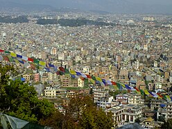
The Kathmandu Valley, also known as the Nepal Valley or Nepa Valley, National Capital Area, is a bowl-shaped valley located in the Himalayan mountains of Nepal. It lies at the crossroads of ancient civilizations of the Indian subcontinent and the broader Asian continent, and has at least 130 important monuments, including several pilgrimage sites for Hindus and Buddhists. There are seven World Heritage Sites within the valley.
Dhangadhi is a sub-metropolitan city and the district headquarters of Kailali District in Sudurpashchim Province of Nepal. It shares a border with India in the south, Godawari and Gauriganga Municipality in the North, Kailari Rural Municipality in the east and Kanchanpur District in the west. Dhangadhi is a sub-metropolis divided into 19 wards. It has an area of 271.74 Sq. KM. It is one of the major cities of Far - West Province of Nepal along with Mahendranagar. The city is connected with the Mahakali Highway, about 750 kilometers west of Kathmandu.
Kathmandu District is a district located in Kathmandu Valley, Bagmati Province of Nepal. It is one of the 77 districts of Nepal, covers an area of 413.69 km2 (159.73 sq mi), and is the most densely populated district of Nepal with 1,081,845 inhabitants in 2001, 1,744,240 in 2011 and 2,017,532 in 2021. The administrative headquarters of Kathmandu district is located in Kathmandu. The city has 21 post offices which handle mail from across the country and beyond, with Kathmandu DPO having 44,600 as its postal code for international mail delivery services like UPS or DHL Couriers etc.
Makwanpur District(Nepali: मकवानपुर जिल्ला;, in Bagmati Province, earlier a part of Narayani Zone, is one of the seventy-seven districts of Nepal. The city of Hetauda serves as the district headquarters and also as the provincial headquarters. The district covers an area of 2,426 km2 and had a population of 392,604 in 2001 and 420,477 in 2011. The latest census of 2021 recorded the population of Makwanpur as 466,073.
The administrative divisions of Nepal are subnational administrative units of Nepal. The first level of country subdivision of Nepal are the provinces. Each province is further subdivided into districts, each district into municipalities and rural municipalities, and each of those municipalities into wards. Before 2015, instead of provinces, Nepal was divided into developmental regions and administrative zones.
Butwal, officially Butwal Sub-Metropolitan City ,previously known as Khasyauli, is a sub-metropolitan city and economic hub in Lumbini Province in West Nepal. Butwal has a city population of 195,054 as per the 2021 AD Nepal census.
Hetauda is a sub-metropolitan city in Makwanpur district of Bagmati Province in central Nepal. It is the administrative headquarters of the Makwanpur district and the capital of Bagmati Province as declared by a majority of the Provincial Assembly Members on 12 January 2020. Hetauda is one of the largest cities in Nepal. At the 2015 Nepal census, it had a population of 153,875 people. The city's population grew to 195,951 in 2021.
Itahari is a sub-metropolitan city in the Sunsari District of Koshi Province in Nepal. Itahari city has grown as an important business hub of eastern Nepal. It is the second most populous city in eastern Nepal after Biratnagar. Situated 25 kilometres north of the provincial capital of Biratnagar, 16 kilometres south of Dharan and 92 kilometres west of Kakarbhitta, Itahari serves as a junction point of the east-west Mahendra Highway and the north–south Koshi Highway. Itahari has an estimated city population of 1,98,098 living in 40,207 households as per 2021 Nepal census. It is one of the fastest-growing cities in Eastern Nepal. It is one of the cities of the Greater Birat Development Area which incorporates the cities of Biratnagar-Itahari-Gothgau-Biratchowk-Dharan primarily located on the Koshi Highway in Eastern Nepal, with an estimated total urban agglomerated population of 804,300 people living in 159,332 households.
Mahakulung is a rural municipality (gaunpalika) out of seven rural municipalities located in Solukhumbu District of Province No. 1 of Nepal. There are a total of 8 municipalities in Solukhumbu in which 1 is urban and 7 are rural.
Budhanilkantha is a city and municipality in Kathmandu district of Bagmati province of Nepal. It is the 3rd largest city in the Kathmandu Valley after Kathmandu and Lalitpur. As per 2021 Nepal census, the city population was 179,688 and 26,678 households.
Nijgadh, is a town and municipality in Nepal, located in Bara District of the Madhesh Province. The total area of the municipality is 289.4 sq. km. The municipality was formed on 8 May 2014 by merging Nijgadh VDC with Ratnapuri VDC and Bharatganj Singaul VDC.
Tilottama Municipality is a municipality in Lumbini Province in western Nepal. Tilottama has a city population of 149,657 as per 2021 AD Nepal census. It is one of the tri-cities of rapidly growing Butwal-Tilottama-Bhairahawa urban agglomeration primarily based on the Siddhartha Highway in West Nepal with a total urban agglomerated population of 421,018. It was formed on May 8, 2014; when the Government of Nepal announced additional 72 municipalities, including previously proposed 37 municipalities in line with the Local Self-governance Act, 1999. On July 25, 2014; demarcation of the municipality was done along with the assignment of new wards. The original demarcation included six existing VDCs viz. Shankarnagar VDC, Aanandaban VDC, Karahiya VDC, Makrahar VDC, Tikuligadh VDC & Madhabaliya VDC. Gangoliya VDC was later merged in the municipality on 17 September 2015.
Belbari, officially known as Belbari municipality, is one of the major suburb of Morang district, Province No. 1. It lies in the eastern Terai region of Nepal. Previously a Village Development Committee (VDC), it was upgraded to the municipality status in 2014. In order to meet the requirements to become a municipality, Belbari VDC merged Kaseni VDC with itself, making it larger in total area. Moreover, in 2017 AD VDC like Dangihat and Bahuni merged with it to become present Belbari Municipality. Now it have 11 wards offices. It had a population of 81,837 people living in 18,945 households making it the third most populous city in Morang district.
Sundar Haraicha is a municipality in Morang District of Koshi Province in Nepal. It is centered around Biratchowk town which is the gateway to Biratnagar. It borders Itahari Sub- Metropolitan city to the west, Dharan Sub- Metropolitan city to the Northwest and Belbari municipality to the east and is connected by Mahendra Highway. It is one of the fastest growing cities in eastern Nepal and the second largest city of Morang district after Biratnagar, with 121,305 inhabitants living in 26,677 households. It consists of the town centres of Biratchowk and Gothgaun which are parts of the Greater Birat Development Area which incorporates the cities of Biratnagar-Itahari-Gothgau-Biratchowk-Dharan primarily located on the Koshi Highway in Eastern Nepal, with an estimated total urban agglomerated population of 804,300 people living in 159,332 households.
Bishnupur is a rural municipality in Saptari District in the Sagarmatha Zone of south-eastern Nepal. At the time of the 2021 Nepal census it had a population of 27,703 people living in 5465 individual households.
Sitganga Municipality is a municipality located in the Arghakhanchi District in the Lumbini Province in Nepal. The municipality spans 610.43 square kilometres with a total population of 43,373, according to the 2011 Nepal census.
A Ward is a smallest unit of Local government in Nepal. The local level body which is divided into 753 units, are further divided into 6,743 Wards. These wards were previously either a single VDC or a part of VDC. A local level unit is divided into minimum 5 wards or maximum 33 wards.
{{cite web}}
: CS1 maint: archived copy as title (link){{cite web}}
: CS1 maint: archived copy as title (link)