
Kent County is a county located in the U.S. state of Maryland. As of the 2010 census, its population was 20,197, making it the least populous county in Maryland. Its county seat is Chestertown. The county was named for the county of Kent in England. The county is located on Maryland's Eastern Shore. It is one of three counties in Maryland, along with Caroline and Garrett, that is not part of a Metropolitan Statistical Area.

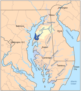
The Chesapeake Bay is the largest estuary in the United States. The Bay is located in the Mid-Atlantic region and is primarily separated from the Atlantic Ocean by the Delmarva Peninsula with its mouth of the Bay at the south end located between Cape Henry and Cape Charles. With its northern portion in Maryland and the southern part in Virginia, the Chesapeake Bay is a very important feature for the ecology and economy of those two states, as well as others surrounding within its watershed. More than 150 major rivers and streams flow into the Bay's 64,299-square-mile (166,534 km2) drainage basin, which covers parts of six states and all of Washington, D.C.

Queen Anne's County is located on the Eastern Shore of the U.S. state of Maryland. As of the 2010 census, the population was 47,798. Its county seat and most populous municipality is Centreville. The census-designated place of Stevensville is the county's most populous place. The county is named for Queen Anne of Great Britain, who reigned when the county was established in 1706 during the colonial period.

The Delmarva Peninsula, or simply Delmarva, is a large peninsula on the East Coast of the United States, occupied by the vast majority of the state of Delaware and parts of the Eastern Shore regions of Maryland and Virginia. The peninsula is 170 miles (274 km) long. In width, it ranges from 70 miles (113 km) near its center, to 12 miles (19 km) at the isthmus on its northern edge, to less near its southern tip of Cape Charles. It is bordered by the Chesapeake Bay on the west, Pocomoke Sound on the northwest, the Delaware River, Delaware Bay, and the Atlantic Ocean on the east.
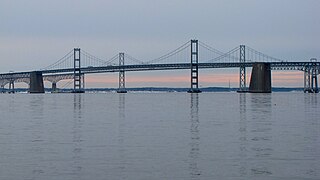
The Chesapeake Bay Bridge is a major dual-span bridge in the U.S. state of Maryland. Spanning the Chesapeake Bay, it connects the state's rural Eastern Shore region with the urban Western Shore, between Stevensville and the capital city of Annapolis. The original span, opened in 1952 and with a length of 4.3 miles (6.9 km), was the world's longest continuous over-water steel structure. The parallel span was added in 1973. The bridge is officially named the Gov. William Preston Lane Jr. Memorial Bridge after William Preston Lane Jr. who, as the 52nd Governor of Maryland, initiated its construction in the late 1940s finally after decades of political indecision and public controversy.

The Eastern Shore of Maryland is a part of the U.S. state of Maryland that lies mostly on the east side of the Chesapeake Bay and consists of nine counties, seven of which have Chesapeake Bay coastlines, one is inland, and the remaining county, Worcester, contains Maryland's only coast along the Atlantic Ocean.
The Chester River is a major tributary of the Chesapeake Bay on the Delmarva Peninsula. It is about 43 miles (69 km) long, and its watershed encompasses 368 sq mi (950 km2), which includes 295 sq mi (760 km2) of land. Thus the total watershed area is 20% water. It forms the border between Kent County and Queen Anne's County, Maryland, with its headwaters extending into New Castle County and Kent County, Delaware. Chestertown, the seat of Maryland's Kent County, is located on its north shore. It is located south of the Sassafras River and north of Eastern Bay, and is connected with Eastern Bay through Kent Narrows.

Chesapeake College is a public community college with its main campus in Wye Mills, Maryland and a satellite campus in Cambridge. It was the first regional community college in the state and serves the five Mid-Shore counties: Caroline, Dorchester, Kent, Queen Anne's, and Talbot.

Kent Island is the largest island in the Chesapeake Bay and a historic place in Maryland. To the east, a narrow channel known as the Kent Narrows barely separates the island from the Delmarva Peninsula, and on the other side, the island is separated from Sandy Point, an area near Annapolis, by roughly four miles (6.4 km) of water. At only four miles wide, the main waterway of the bay is at its narrowest at this point and is spanned here by the Chesapeake Bay Bridge. The Chester River runs to the north of the island and empties into the Chesapeake Bay at Kent Island's Love Point. To the south of the island lies Eastern Bay. The United States Census Bureau reports that the island has 31.62 square miles (81.90 km2) of land area.
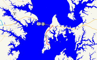
Maryland Route 8 is a state highway in the U.S. state of Maryland. Known for most of its length as Romancoke Road, the state highway runs 8.37 miles (13.47 km) from Romancoke Pier in Romancoke north to MD 18 in Stevensville. MD 8 is the main north–south highway of Kent Island in western Queen Anne's County. The state highway is also the first highway encountered on U.S. Route 50 and US 301 east of the Chesapeake Bay Bridge. South of Matapeake, MD 8 is paralleled by the Kent Island South Trail.

The Eastern Bay is a tributary of the Chesapeake Bay located between Queen Anne's County, Maryland and Talbot County, Maryland on the Eastern Shore. Its main tributaries include the Miles River and the Wye River. It is located south of the Chester River and north of the Choptank River and is connected to the Chester River via Kent Narrows.
U.S. Route 301 (US 301) in the state of Maryland is a major highway that runs from Delaware to the Governor Harry W. Nice Memorial Bridge over the Potomac River into Virginia. It passes through three of Maryland's four main regions: the Eastern Shore, the Baltimore-Washington Metropolitan Area, and Southern Maryland. US 301 serves mainly as a bypass of Baltimore and Washington from Delaware to Virginia.

The log canoe is a type of sailboat developed in the Chesapeake Bay region. Based on the dugout, it was the principal traditional fishing boat of the bay until superseded by the bugeye and the skipjack. However, it is most famous as a racing sailboat, and races continue to be held.

The Cross Island Trail is a rail trail in Queen Anne's County, Maryland occupying a section of the abandoned Queen Anne's Railroad corridor that traverses the width of Kent Island. It was completed in 2001 and is part of the American Discovery Trail.
Matapeake is an unincorporated community located south of Stevensville on Kent Island, Maryland, United States.

Matapeake State Park is a public recreation area on Chesapeake Bay occupying the site of a former ferry landing in Matapeake, Kent Island, Maryland. The landing served the state-owned Chesapeake Bay Ferry System before the Chesapeake Bay Bridge opened. The park is leased and managed by Queen Anne's County.
Wheeler R. Baker is a former member of the Maryland House of Delegates, serving District 36, which covers Caroline, Cecil, Kent, and Queen Anne's Counties. Mr. Baker is known for his colorful home-spun language. He is quoted as saying such things as "I just feel like I can carry the water pail better than he can." and "I tell people we need to knock the dents out from the inside."

Dominion is an unincorporated community located in Kent Island which is in Queen Anne's County, Maryland, United States. Dominion is located along Maryland Route 552, 2 miles (3.2 km) south of Chester.
Kent County News is a weekly newspaper published in Chestertown, Maryland. The paper is published once a week on Thursday. The first publication was in 1947, but the paper can be traced back to the Chestertown Spy which was established in 1793. It is one of the nation's oldest newspapers. The paper serves Kent County and the city of Chestertown on the Eastern Shore of Maryland.
The James E. Kirwan House and Store is a living museum located south of the village of Chester on Kent Island, Queen Anne's County, Maryland. It served as a general store, lumber mill, cooper's mill, and blacksmith shop between 1889 and 1955 and facilitated local trade as a port on Kirwan Creek. The estate was donated to the Kent Island Heritage Society in 1998 to be run as a museum.