
Hunterdon County is a county located in the western section of the U.S. state of New Jersey. At the 2020 census, the county was the state's 18th-most populous county, with a population of 128,947, its highest decennial count ever and an increase of 598 (+0.5%) from the 2010 census count of 128,349, which in turn reflected an increase of 6,360 (5.2%) from the 121,989 counted in the 2000 census. Its county seat is Flemington. The county is part of the Central Jersey region of the state.

East Amwell Township is a township in Hunterdon County, in the U.S. state of New Jersey. As of the 2020 United States census, the township's population was 3,917, a decrease of 96 (−2.4%) from the 2010 census count of 4,013, which in turn reflected a decline of 442 (−9.9%) from the 4,455 counted in the 2000 census.

West Amwell Township is a township in Hunterdon County, in the U.S. state of New Jersey. As of the 2020 United States census, the township's population was 3,005, a decrease of 835 (−21.7%) from the 2010 census count of 3,840, which in turn reflected an increase of 1,457 (+61.1%) from the 2,383 counted in the 2000 census.
Solebury Township is a township in Bucks County, Pennsylvania, United States. The population was 8,709 at the 2020 census.

County Route 579 is a county highway in the U.S. state of New Jersey. The highway extends 37.24 miles (59.93 km) from John Fitch Parkway in Trenton to Route 173 in Greenwich Township.

The Skylands Region is a region of New Jersey located in the northern and central parts of the state. It is one of six tourism regions established by the New Jersey State Department of Tourism; the others are Gateway Region, Greater Atlantic City Region, the Southern Shore Region, the Delaware River Region, and the Shore Region.
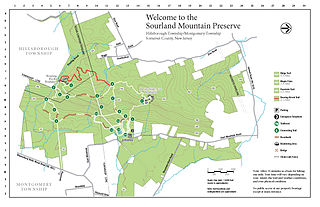
The Sourland Mountain Preserve is located on Sourland Mountain, in the Sourlands region of New Jersey. It is within Hillsborough Township and Montgomery Township of Somerset County. The largest donation of land was made by Norma Gilbert Farr, trustee of the Linus R. Gilbert Foundation. The Farr family has donated over 3,000 acres to the Sourland Mountain Preserve and the Somerset County Parks Commission.

County Route 518 is a county highway in the U.S. state of New Jersey. The highway extends 20.58 miles (33.12 km) from Route 29/Route 165 in Lambertville to Lincoln Highway in Franklin Township. It is also known as the Georgetown Franklin Turnpike.

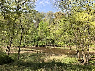
Sourland Mountain is a 17 miles (27 km) long ridge in central New Jersey, U.S., extending from the Delaware River at Lambertville to the western end of Hillsborough Township near the community of Neshanic, through Montgomery Township and into Hopewell Township in Mercer County. It comprises the largest contiguous forest in Central Jersey, nearly 90 square miles (233 km2) in area. The highest point is only 568 feet (173 m) above sea level, but the way it rises steeply from the surrounding farmland has earned it the title of 'mountain'. The ridge itself sits within a larger area of rough terrain called The Sourlands.

Cushetunk Mountain is a ring shaped mountain in the U.S. state of New Jersey, located in Readington and Clinton Township in Hunterdon County. The Lenape Native Americans called the mountain "Cushetunk" meaning "place of hogs" after the wild hogs found there. In the 1960s, the valley at the heart of the mountain was dammed and filled with water to create Round Valley Reservoir. Today, the mountain and its accompanying lake act as a vital water supply to Central New Jersey, while at the same time providing numerous recreational opportunities to the region.

The Amwell Valley is a small valley in Hunterdon County, New Jersey, between the Hunterdon Plateau and the Sourlands. It comprises Stockton, parts of Delaware Township, West Amwell, East Amwell, Flemington and Raritan Township. The region borders the Delaware River to the west and the South Branch Raritan River to the east. The entire area has elevations around 200 feet above sea level. US 202 is the main route running west to east through the valley. Old York Road also passes through the valley, taking a generally more southern route through Raritan and along the Sourlands at Mount Airy. Like the Hunterdon Plateau, Amwell Valley still has a large number of farms due to its sufficient climate, relatively flat land and the presence of silt-loams soils. The valley is home to Unionville Winery and Old York Cellars in Ringoes.
Hunterdon Plateau is a plateau in western Hunterdon County, New Jersey. It borders the higher Musconetcong Mountain to the northwest, the Delaware River to the west, Amwell Valley to the south and the lower lying areas of the Newark Basin to the east.
Mount Rose is a narrow section of the Rocky Hill Ridge in Hopewell Township, New Jersey which is 420 feet above sea level. The ridge's western end is at The Sourlands at Hopewell-Pennington Road and its eastern end is near Province Line Road. The ridge is a diabase intrusion and unlike many of the ridges in the state, it runs from northwest to southeast. Crusher Road travels along the ridge. Pennington-Rocky Hill Road, Cherry Valley Road, Hopewell-Princeton Road and Carter Road meet at a low point along the ridge at the village of Mount Rose.
Rocky Hill Ridge, also known as the Mount Lucas-Rocky Hill Ridge, named after Lucas Voorhees, an 18th-century landowner, is a diabase trap rock ridge running west to east in the US State of New Jersey. Diabase intrusions form Baldpate Mountain and Pennington Mountain, the Mount Rose extension of the Mount Lucas-Rocky Hill ridge, and part of the Sourland Mountains. The Ridge is nine miles (14 km) long and continues across the Millstone River, just below The Georgetown Franklin Turnpike, as the Ten-Mile Run Mountain and Lawrence Brook Mountain. The western section of the ridge, which runs to the northwest to The Sourlands, is the Mount Rose section of the ridge.

Cloverhill is an unincorporated community located at the intersection of the boundaries of East Amwell and Raritan townships in Hunterdon County and Hillsborough Township in Somerset County, in the U.S. state of New Jersey. The Clover Hill Historic District was listed on the state and national registers of historic places in 1980.

Snydertown is an unincorporated community located within East Amwell Township in Hunterdon County, in the U.S. state of New Jersey. The settlement is located on the southern face of Sourland Mountain at the intersection of Linvale Road and Snydertown Road. In the past, a mill operated in Snydertown.

Wertsville is an unincorporated community located along County Route 602 in East Amwell Township of Hunterdon County, in the U.S. state of New Jersey.

Vanlieu Corners is an unincorporated community in East Amwell Township in Hunterdon County, in the U.S. state of New Jersey.
Jacobs Creek is a tributary of the Delaware River in Mercer County in the U.S. state of New Jersey. From its headwaters in Hopewell Township, the creek flows generally south and southwest. Along the creek's lower course, it flows along the border between Hopewell Township and Ewing Township, entering the Delaware River between Lambertville and Trenton.
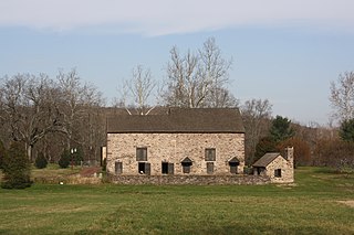
The New Market–Linvale–Snydertown Historic District is a 160-acre (65 ha) historic district located along NJ 31, Linvale, Snydertown, and Woodsville Roads in the communities of Linvale, formerly known as New Market, and Snydertown in the townships of East Amwell and West Amwell in Hunterdon County, New Jersey, United States. It was added to the National Register of Historic Places on February 12, 1998, for its significance in architecture, commerce, settlement, and community development. The district includes 33 contributing buildings, four contributing structures, and one contributing object.


