Chesterfield, originally known as Recklesstown, is an unincorporated community located around the intersection of County Route 528 and County Route 677 in Chesterfield Township of Burlington County, New Jersey.

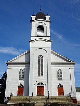
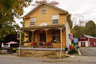
Pottersville is an unincorporated community split between Bedminster Township in Somerset County, Tewksbury Township in Hunterdon County and Washington Township in Morris County, New Jersey, United States. The area is served as United States Postal Service ZIP Code 07979. As of the 2010 United States Census, the population for ZIP Code Tabulation Area 07979 was 589. In 1990, most of the village was listed on the National Register of Historic Places as the Pottersville Village Historic District.

The Abbott Farm Historic District is a National Historic Landmark archaeological site in New Jersey. It is the largest known Middle Woodland village of its type on the East Coast of the United States. Significant evidence suggests that the Delaware River floodplain was occupied by Paleoindian people for a long period. It was inhabited between 500 BC and 500 AD. It has been a source of controversy and debate around early development.
Readington Village is an unincorporated community located within Readington Township in Hunterdon County, New Jersey, United States, that is centered on the converging of Readington Road, Hillcrest Road, Centerville Road and Brookview Road. It is located on Holland Brook, originally named Amanmechunk, which means large creek in the Unami dialect. The area was inhabited by the Raritan prior to the arrival of European settlers. The Native Americans who lived near Readington Village travelled to the coast during the summer for fish and clams. Such a trip is mentioned in an Indian deed transferring lands around Holland Brook to George Willocks, an East and West New Jersey Proprietor. The deed mentions two of the natives, who lived at Readington: Metamisco and Wataminian.

Arneytown is an unincorporated community located along Province Line Road on the border of North Hanover Township in Burlington County and Upper Freehold Township in Monmouth County of New Jersey. It is two miles (3.2 km) north of Jacobstown. Province Line Road was on the boundary line between the Provinces of East Jersey and West Jersey. The area was once called Upper Freehold by 18th-century Quaker settlers. With the establishment of the first post office in 1827, it became known as Arneytown.

Atsion is an unincorporated community located within Shamong Township in Burlington County, New Jersey, United States. The community is located next to Atsion Lake.

Little York is an unincorporated community located along the border of Alexandria and Holland townships in Hunterdon County, New Jersey, United States. Little York is located on County Route 614 3.1 miles (5.0 km) north-northeast of Milford. Little York has a post office with ZIP code 08834.

Everittstown is an unincorporated community located within Alexandria Township, in Hunterdon County, New Jersey, United States. The Everittstown Historic District was listed on the National Register of Historic Places in 1980.
Mount Pleasant is an unincorporated community located along County Route 519 on the border of Alexandria Township and Holland Township, in Hunterdon County, New Jersey. The Mount Pleasant Historic District was listed on the National Register of Historic Places in 1987.

Readingsburg, also known as Stone Mill, is an unincorporated community located along the South Branch Raritan River within Clinton Township in Hunterdon County, New Jersey.

Pleasant Valley is an unincorporated community located within Hopewell Township in Mercer County, New Jersey. The Howell Living History Farm, also known as the Joseph Phillips Farm, is located in the community.
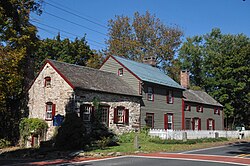
Amsterdam is an unincorporated community located within Holland Township in Hunterdon County, New Jersey. Located on the southern flank of the Musconetcong Mountain, the area was settled in the first half of the 18th century. It was later named after Amsterdam, Netherlands. The Amsterdam Historic District, encompassing the community, was listed on the state and national registers of historic places in 1995.

Cloverhill is an unincorporated community located at the intersection of the boundaries of East Amwell and Raritan townships in Hunterdon County and Hillsborough Township in Somerset County, in New Jersey, United States. The Clover Hill Historic District was listed on the state and national registers of historic places in 1980.
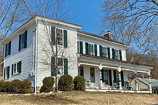
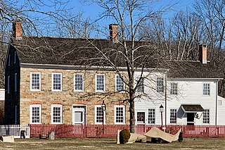
Mountainville is an unincorporated community located within Tewksbury Township in Hunterdon County, New Jersey. The Mountainville Historic District was listed on the National Register of Historic Places in 1993.

Reaville is an unincorporated community located along the border of East Amwell and Raritan townships in Hunterdon County, New Jersey. By the 1830s, it was known as Greenville. It was later renamed after Runkle Rea, the first postmaster in 1850.
Van Syckel is an unincorporated community located within Union Township in Hunterdon County, New Jersey. The Van Syckel Corner District was listed on the National Register of Historic Places in 1979.

Wertsville is an unincorporated community located along County Route 602 in East Amwell Township of Hunterdon County, New Jersey, United States.

Middle Valley is an unincorporated community located along Middle Valley Road and County Route 513 in Washington Township, Morris County, New Jersey. It is near Long Valley in the valley of the South Branch Raritan River. The Middle Valley Historic District was listed on the state and national registers of historic places in 1989 and 1990.
Middletown Village is an unincorporated community located in the central part of Middletown Township, Monmouth County, New Jersey. It was the first settlement in the township and one of the oldest in New Jersey. The Middletown Village Historic District, encompassing the community, was listed on the state and national registers of historic places in 1974.

Bevans, also known as Peters Valley, is an unincorporated community located at the intersection of Bevans Road, Walpack Road, and Kuhn Road in Sandyston Township of Sussex County, New Jersey. The village is now part of the Delaware Water Gap National Recreation Area. Both the Delaware River and the Old Mine Road are nearby.