Route 29 is a state highway in the U.S. state of New Jersey. Signed north-south, it runs 34.76 mi (55.94 km) from an interchange with Interstate 295 (I-295) in Hamilton Township in Mercer County, where the road continues east as I-195, northwest to Route 12 in Frenchtown, Hunterdon County. Between the southern terminus and I-295 in Ewing Township, the route is a mix of freeway and expressway that runs along the Delaware River through Trenton. This section includes a truck-restricted tunnel that was built along the river near historic houses and Riverview Cemetery. North of I-295, Route 29 turns into a scenic and mostly two-lane highway. North of the South Trenton Tunnel, it is designated the Delaware River Scenic Byway, a New Jersey Scenic Byway and National Scenic Byway, that follows the Delaware River in mostly rural sections of Mercer County and Hunterdon County. The obsolete Delaware & Raritan Canal usually stands between the river and the highway. Most sections of this portion of Route 29 are completely shaded due to the tree canopy. Route 29 also has a spur, Route 129, which connects Route 29 to U.S. Route 1 (US 1) in Trenton.

Route 26 is a state highway in New Jersey, United States, running 2.54 miles (4.09 km) along Livingston Avenue from U.S. Route 1 (US 1) in North Brunswick Township northeast to Nassau Street at the border of New Brunswick. Prior to the 1953 renumbering, the route continued southwest along US 1 to Trenton. Livingston Avenue inside New Brunswick, southwest of Suydam Street, is the 1.08-mile (1.74 km) County Route 691 (CR 691). The 0.39 miles (0.63 km) from Suydam Street to its end at George Street is part of Route 171, also maintained by Middlesex County.

Morrisville is a borough in Bucks County, Pennsylvania, United States. It is located just below the falls of the Delaware River opposite Trenton, New Jersey. The population was 9,809 in the 2020 Census.

The Delaware Valley, sometimes referred to as Greater Philadelphia or the Philadelphia metropolitan area, is a metropolitan region in the Northeast United States that centers around Philadelphia, the nation's sixth-most populous city, and spans parts of four U.S. states: southeastern Pennsylvania, southern New Jersey, northern Delaware, and the northern Eastern Shore of Maryland. With a core metropolitan statistical area population of 6.288 million residents and a combined statistical area population of 7.366 million as of the 2020 census, the Delaware Valley is the eighth-largest metropolitan region in the nation and North America, and the 68th-largest metropolitan region in the world.

The Calhoun Street Extension is a series of roads in Trenton, New Jersey and nearby Lawrence Township. It runs from the Calhoun Street Bridge over the Delaware River to Brunswick Circle, and is composed of the following named streets:
The Delaware River Joint Toll Bridge Commission (DRJTBC) is a bistate, public agency that maintains and operates river crossings connecting the U.S. states of Pennsylvania and New Jersey. The agency's jurisdiction stretches roughly 140 miles (230 km) along the Delaware River from Philadelphia and Bucks County in southeast Pennsylvania and then north through the Lehigh Valley and to Pennsylvania-New York state border.
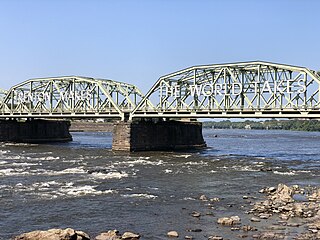
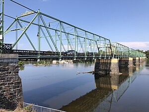
The Lower Trenton Toll Supported Bridge, commonly called the Lower Free Bridge, Warren Street Bridge or Trenton Makes Bridge, is a two-lane Pennsylvania (Petit) through truss bridge that crosses over the Delaware River between Trenton, New Jersey and Morrisville, Pennsylvania.

U.S. Route 1 Business is a four-lane surface road that provides an alternate route to the Trenton Freeway (US 1) northeast of Trenton in Mercer County, New Jersey. The route is 2.73 miles (4.39 km) long and runs between US 1 in Trenton and Lawrence Township. On the border of Trenton and Lawrence Township, US 1 Bus. intersects the northbound direction of US 206 at the Brunswick Circle. The route was once part of a longer U.S. Route 1 Alternate, which continued southwest through downtown Trenton and into Morrisville, Pennsylvania.
Pennsylvania Route 32 is a scenic two-lane highway that runs along the west side of the Delaware River in Bucks County, Pennsylvania. Signed north-south, it runs from U.S. Route 1 in Falls Township outside of Morrisville northwest to PA 611 in the village of Kintnersville in Nockamixon Township. PA 32 passes through Washington Crossing Historic Park, a Revolutionary War-themed historical park on the site of George Washington's crossing on the night of December 25–26, 1776. It also passes through the boroughs of Morrisville, Yardley, and New Hope.

The Pennsylvania Turnpike/Interstate 95 Interchange Project is a road construction project that built an interchange between Interstate 95 (I-95) and the Pennsylvania Turnpike in Bristol Township, Bucks County, Pennsylvania, in the United States. The $553 million first stage is complete: a pair of flyover ramps–one connecting I-95 northbound with the eastbound turnpike and the other connecting the westbound turnpike with I-95 southbound—that opened in 2018, with some cleanups to connecting roads completed in 2021. Construction of the remaining ramps is expected to begin when funding is available.

The Trenton–Morrisville Toll Bridge is one of three road bridges connecting Trenton, New Jersey with Morrisville, Pennsylvania. Opened on December 1, 1952, it carries U.S. Route 1 (US 1) and is owned and operated by the Delaware River Joint Toll Bridge Commission.

The Morrisville–Trenton Railroad Bridge is a rail bridge across the Delaware River between Morrisville, Pennsylvania and Trenton, Mercer County, New Jersey, United States.

Interstate 95 (I-95) is a major north–south Interstate Highway that runs along the East Coast of the United States from Miami, Florida, north to the Canada–United States border at Houlton, Maine. In the state of Pennsylvania, it runs 51.00 miles (82.08 km) from the Delaware state line near Marcus Hook in Delaware County in the southeastern part of the state northeast to the Delaware River–Turnpike Toll Bridge at the New Jersey state line near Bristol in Bucks County, closely paralleling the New Jersey state line for its entire length through Pennsylvania.

The Centre Bridge–Stockton Bridge is a free bridge over the Delaware River owned and operated by the Delaware River Joint Toll Bridge Commission. The bridge connects CR 523 and NJ 29 in Stockton, in Hunterdon County, New Jersey to PA 263 in Centre Bridge, Solebury Township, Bucks County, Pennsylvania, United States.
U.S. Route 1 (US 1) is a U.S. Route which parallels the East Coast of the United States, running from Key West, Florida, in the south to Fort Kent, Maine, at the Canadian border in the north. Of the entire length of the route, 66.06 miles (106.31 km) of it runs through New Jersey. It enters the state from Pennsylvania on the Trenton–Morrisville Toll Bridge over the Delaware River in the state capital of Trenton, running through the city on the Trenton Freeway. From here, US 1 continues northeast as a surface divided highway through suburban areas, heading into Middlesex County and passing through New Brunswick and Edison. US 1 merges with US 9 in Woodbridge, and the two routes continue through northern New Jersey as US 1/9 to the George Washington Bridge over the Hudson River in Fort Lee. At this point, the road continues into New York City along with I-95.

Washington Crossing Bridge is a truss bridge spanning the Delaware River that connects Washington Crossing, Hopewell Township in Mercer County, New Jersey with Washington Crossing, Upper Makefield Township in Bucks County, Pennsylvania. It was built in 1904 by the Taylorsville Delaware Bridge Company. It serves as the connector of Pennsylvania Route 532 on the Pennsylvania side, with County Route 546 on the New Jersey side. The bridge is currently owned and operated by the Delaware River Joint Toll Bridge Commission.
U.S. Route 1 (US 1) is a major north–south U.S. Route, extending from Key West, Florida, in the south to Fort Kent, Maine, at the Canada–United States border in the north. In the U.S. state of Pennsylvania, US 1 runs for 81 miles (130 km) from the Maryland state line near Nottingham northeast to the New Jersey state line at the Delaware River in Morrisville, through the southeastern portion of the state. The route runs southwest to northeast and serves as a major arterial road through the city of Philadelphia and for many of the suburbs in the Delaware Valley metropolitan area. South of Philadelphia, the road mostly follows the alignment of the Baltimore Pike. Within Philadelphia, it mostly follows Roosevelt Boulevard. North of Philadelphia, US 1 parallels the route of the Lincoln Highway. Several portions of US 1 in Pennsylvania are freeways, including from near the Maryland state line to Kennett Square, the bypass of Media, the concurrency with Interstate 76 and the Roosevelt Expressway in Philadelphia, and between Bensalem Township and the New Jersey state line.

The Riegelsville Bridge is a suspension bridge crossing the Delaware River at Riegelsville, Pennsylvania, connecting it with Riegelsville, New Jersey, United States.

The Riverton–Belvidere Bridge is a bridge that crosses the Delaware River and connects Belvidere, New Jersey in the east with Riverton, Pennsylvania in the Lehigh Valley region of eastern Pennsylvania in the west.

U.S. Route 13 (US 13) is a United States Numbered Highway running from Fayetteville, North Carolina, north to Morrisville, Pennsylvania. The route runs for 49.359 miles (79.436 km) through the Delaware Valley in the U.S. state of Pennsylvania. The route enters the state from Delaware in Marcus Hook, Delaware County. It continues northeast through Delaware County, passing through the city of Chester before heading through suburban areas along Chester Pike to Darby. US 13 enters the city of Philadelphia on Baltimore Avenue and runs through West Philadelphia to University City, where it turns north along several city streets before heading east across the Schuylkill River along Girard Avenue. The route turns north and heads to North Philadelphia, where it runs northeast along Hunting Park Avenue. US 13 becomes concurrent with US 1 on Roosevelt Boulevard, continuing into Northeast Philadelphia. US 13 splits southeast on a one-way pair of streets before heading northeast out of the city on Frankford Avenue. The route continues into Bucks County as Bristol Pike, heading northeast to Bristol, where it turns into a divided highway. US 13 becomes a freeway in Tullytown and continues north to its terminus at US 1 in Falls Township, near Morrisville. US 13 roughly parallels Interstate 95 (I-95) through its course in Pennsylvania.