List of bridges on the National Register of Historic Places in Texas

Last updated

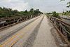
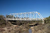
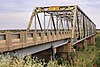
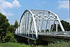
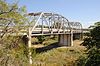
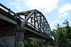
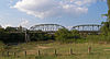
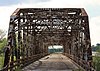
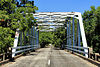
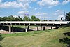
This is a list of bridges currently on the National Register of Historic Places in the U.S. state of Texas. [1]

NameImageBuiltListedLocationCountyType
Allen Water Station 19102009-12-03 Allen
33°07′02″N96°39′58″W / 33.11725°N 96.666008°W / 33.11725; -96.666008 (Allen Water Station)
Collin Unknown bridge type. Included in Historic District listing
Almeda Road Bridge over Brays Bayou Almeda Road Bridge over Brays Bayou.jpg 19312007-11-29 Houston
29°42′47.5″N95°22′55.5″W / 29.713194°N 95.382083°W / 29.713194; -95.382083 (Almeda Road Bridge over Brays Bayou)
Harris Continuous span concrete beam
Angelina River Bridge 19351988-12-22 Lufkin
31°27′25″N94°43′34″W / 31.45694°N 94.72611°W / 31.45694; -94.72611 (Angelina River Bridge)
Angelina Span concrete beam
Demolished circa 1998
Beaver Creek Bridge Beaver Creek Bridge.JPG 19251996-10-10 Electra
33°54′21″N98°54′17″W / 33.90583°N 98.90472°W / 33.90583; -98.90472 (Beaver Creek Bridge)
Wichita Warren pony truss
Bedstead Truss Bridge Bedstead Truss Bridge, Schulenburg, Texas.JPG 2013-11-29 Schulenburg
29°40′27″N96°54′39″W / 29.67405°N 96.91084°W / 29.67405; -96.91084 (Bedstead Truss Bridge)
Fayette
Bluff Dale Suspension Bridge BluffDaleBridgeMainSpan.JPG ca. 1895, 1925, 19341977-12-20 Bluff Dale
32°21′15″N98°1′32″W / 32.35417°N 98.02556°W / 32.35417; -98.02556 (Bluff Dale Suspension Bridge)
Erath Cable-stayed
Brackenridge Park Bridge Brackenridge Park Bridge, San Antonio, TX.jpg 18902011-08-04 San Antonio
29°27′48″N98°28′09″W / 29.4632°N 98.4692°W / 29.4632; -98.4692 (Brackenridge Park Bridge)
Bexar Lenticular truss bridge. Included in Brackenridge Park Historic District listing.
Brazoria Bridge Brazoria Bridge Texas 2009.jpg 19391991-06-14 Brazoria
29°3′15″N95°33′25″W / 29.05417°N 95.55694°W / 29.05417; -95.55694 (Brazoria Bridge)
Brazoria Parker through truss
Bunton Branch Bridge Bunton branch bridge 2009.jpg 1915, 1917, 19322002-02-19 Kyle
30°1′5″N97°51′31.5″W / 30.01806°N 97.858750°W / 30.01806; -97.858750 (Bunton Branch Bridge)
Hays Concrete arch
Burr's Ferry Bridge Burrs Ferry Bridge, Burr Ferry, Louisiana.jpg 1936, 19371998-05-18 Burkeville
31°3′50″N93°31′13″W / 31.06389°N 93.52028°W / 31.06389; -93.52028 (Burr's Ferry Bridge)
Newton Parker through truss
Colorado River Bridge Colorado River Bridge Wharton Texas.jpg 19301993-03-18 Wharton
29°18′30″N96°6′13″W / 29.30833°N 96.10361°W / 29.30833; -96.10361 (Colorado River Bridge)
Wharton Parker though truss
Colorado River Bridge at Bastrop Colorado river bridge at bastrop 2006.jpg 19231990-07-19 Bastrop
30°6′35.25″N97°19′21.75″W / 30.1097917°N 97.3227083°W / 30.1097917; -97.3227083 (Colorado River Bridge at Bastrop)
Bastrop Parker through truss
Cow Bayou Swing Bridge Cow bayou swinging bridge 2015.jpg 19402010-5-10 Bridge City
30°02′41″N93°49′17″W / 30.0448363°N 93.8213807°W / 30.0448363; -93.8213807 (Cow Bayou Swing Bridge)
Orange
Cummins Creek Bridge Bridge Round Top.JPG 18901975-04-21 Round Top
30°4′7″N96°43′9″W / 30.06861°N 96.71917°W / 30.06861; -96.71917 (Cummins Creek Bridge)
Fayette Pratt through truss
Deweyville Swing Bridge Deweyville Swing Bridge 1.jpg 19362011-06-08 Deweyville
Newton
Dionicio Rodriguez Bridge in Brackenridge Park Rodriquez bridge brackenridge 2011.jpg ca. 19262004-10-22 San Antonio
29°27′53.5″N98°28′7″W / 29.464861°N 98.46861°W / 29.464861; -98.46861 (Dionicio Rodriguez Bridge in Brackenridge Park)
Bexar Faux Bois sculpture
East Navidad River Bridge GENERAL VIEW OF THE EAST NAVIDAD RIVER BRIDGE, SOUTH SIDE, LOOKING NORTHWEST. - East Navidad River Bridge, Spanning East Navidad River at FM1579, Schulenburg, Fayette County, TX HAER TX,75-SCHU.V,1-2.tif 19232014-8-18 Schulenburg
29°40′59″N96°50′47″W / 29.682939°N 96.846481°W / 29.682939; -96.846481 (East Navidad River Bridge)
Fayette
Faust Street Bridge Faust street bridge 2012.jpg 18872009-3-17 New Braunfels
29°41′48″N98°6′25″W / 29.69667°N 98.10694°W / 29.69667; -98.10694 (Faust Street Bridge)
Comal
Fort Griffin Brazos River Bridge Fort Griffin Iron Truss Bridge, Spanning Clear Fork of Brazos River at County Rout, Fort Griffin vicinity (Shackelford County, Texas).jpg 18851979-10-16 Fort Griffin
32°56′5″N99°13′26″W / 32.93472°N 99.22389°W / 32.93472; -99.22389 (Fort Griffin Brazos River Bridge)
Shackelford Pratt through truss
Galveston Causeway Old Causeway, Galveston.jpg 1912, 19221976-12-12 Galveston
29°17′51″N94°53′12″W / 29.29750°N 94.88667°W / 29.29750; -94.88667 (Galveston Causeway)
Galveston Concrete arch
Gregory Road Bridge at Duck Creek 19232004-01-14 Sanger
33°25′29″N97°13′59″W / 33.42472°N 97.23306°W / 33.42472; -97.23306 (Gregory Road Bridge at Duck Creek)
Denton Warren pony truss
Hays Street Bridge Hays Street Bridge with pedestrians.JPG 19082012-9-10 San Antonio
Bexar Truss. Included in Historic Bridges of Texas MPS
Hill Street Bridge over Buffalo Bayou Hill Street Bridge.JPG 19382007-10-31 Houston
29°45′40″N95°20′36″W / 29.76111°N 95.34333°W / 29.76111; -95.34333 (Hill Street Bridge over Buffalo Bayou)
Harris Steel beam
Houston Street Viaduct Dallas-Oak Cliff Viaduct, Spanning Trinity River at Houston Street, Dallas (Dallas County, Texas).jpg 1910, 19111984-08-09 Dallas
32°46′12″N96°48′31″W / 32.77000°N 96.80861°W / 32.77000; -96.80861 (Houston Street Viaduct)
Dallas Continuous span concrete arch
Hubbard Creek Bridge HubbardCreek1 (1 of 1).jpg 1928, 19291996-10-10 Albany
32°41′25″N99°9′53″W / 32.69028°N 99.16472°W / 32.69028; -99.16472 (Hubbard Creek Bridge)
Shackelford Pratt through truss
Iron Bridge Iron bridge bastrop 2013.jpg 18831978-12-22 Bastrop
30°07′53″N97°19′16″W / 30.1314165°N 97.3210211°W / 30.1314165; -97.3210211 (Iron Bridge)
Bastrop Truss Type
Kansas City, Mexico and Orient Railway and Gulf, Colorado and Santa Fe Railway Overpass Sweetwater Texas Railroad Overpass.jpg 19351984-06-07 Sweetwater Nolan Concrete arched-girder. Included in Sweetwater Commercial Historic District listing
Lamar Boulevard Bridge Lamar Bridge 2007.jpg 1941, 19421994-07-07 Austin
30°15′56.5″N97°45′24″W / 30.265694°N 97.75667°W / 30.265694; -97.75667 (Lamar Boulevard Bridge)
Travis Continuous span concrete arch
Lone Wolf Crossing Bridge Lone Wolf Crossing Bridge (2018), San Angelo, TX.jpg 19221988-11-25 San Angelo
31°26′45″N100°25′30″W / 31.44583°N 100.42500°W / 31.44583; -100.42500 (Lone Wolf Crossing Bridge)
Tom Green Pratt through truss
McKee Street Bridge McKee Street Bridge, Spanning Buffalo Bayou, Houston (Harris County, Texas).jpg 19322002-09-03 Houston
29°45′57″N95°21′7″W / 29.76583°N 95.35194°W / 29.76583; -95.35194 (McKee Street Bridge)
Harris Continuous span concrete beam
Medio Creek Bridge Medio Creek Bridge, Normanna, Texas.JPG 1897, 19231988-10-13 Normanna
28°31′46″N97°47′38″W / 28.52944°N 97.79389°W / 28.52944; -97.79389 (Medio Creek Bridge)
Bee Pratt through truss
Missouri, Kansas & Texas Railroad Bridge at the Leon River 1990-12-26 Belton
31°3′44″N97°26′35″W / 31.06222°N 97.44306°W / 31.06222; -97.44306 (Missouri, Kansas & Texas Railroad Bridge at the Leon River)
Bell Parker through truss
Montopolis Bridge Montopolis bridge 2013.jpg 1937, 19381996-10-10 Austin
30°14′43″N97°41′28″W / 30.24528°N 97.69111°W / 30.24528; -97.69111 (Montopolis Bridge)
Travis Parker through truss
Moore's Crossing Bridge Moores crossing bridge.jpg 19221996-10-16 Austin
30°10′10″N97°39′49″W / 30.16944°N 97.66361°W / 30.16944; -97.66361 (Moore's Crossing Bridge)
Travis Parker through truss. Included in Moore's Crossing Historic District
Mueller Bridge 19152007-10-16 La Vernia
29°21′5″N98°4′28″W / 29.35139°N 98.07444°W / 29.35139; -98.07444 (Mueller Bridge)
Wilson Warren polygonal chord truss
Mulberry Creek Bridge Mulberry Creek Bridge.jpg 18881975-04-21 Schulenburg
29°40′27″N96°54′39″W / 29.67417°N 96.91083°W / 29.67417; -96.91083 (Mulberry Creek Bridge)
Fayette Pratt pony truss. Removed from NRHP on May 20, 2013. [2]
Nolan River Bridge 303-A of the Gulf, Colorado and Santa Fe Railway Nolanriverbridge3.jpg 19032012-12-4Cty. Rd. 1127 at Nolan R.
32°8′50″N97°23′49″W / 32.14722°N 97.39694°W / 32.14722; -97.39694 (Nolan River Bridge 303-A of the Gulf, Colorado and Santa Fe Railway)
Hill
Paddock Viaduct Paddock Viaduct.jpg 1912, 19141976-03-15 Fort Worth
32°45′36″N97°20′5″W / 32.76000°N 97.33472°W / 32.76000; -97.33472 (Paddock Viaduct)
Tarrant Continuous span concrete arch
Port Arthur-Orange Bridge Rainbow Bridge (Texas) side.jpg 1936, 19381996-10-10 Groves
29°58′11″N93°52′24″W / 29.96972°N 93.87333°W / 29.96972; -93.87333 (Port Arthur-Orange Bridge)
Jefferson Cantilever through truss
Rector Road Bridge at Clear Creek Rectorroadbridge1.JPG 1907, 19082004-01-14 Sanger
33°19′50″N97°8′56″W / 33.33056°N 97.14889°W / 33.33056; -97.14889 (Rector Road Bridge at Clear Creek)
Denton Pratt through truss
Relocated to 7501 Teasley Lane, Denton
Regency Suspension Bridge Regency Bridge Side View.JPG 19391976-12-12 Regency
31°24′37″N98°50′45″W / 31.41028°N 98.84583°W / 31.41028; -98.84583 (Regency Suspension Bridge)
Mills Suspension
Riverside Swinging Bridge Riverside Swinging Bridge side view.JPG 19041979-09-12 Riverside
30°51′26″N95°23′46″W / 30.85722°N 95.39611°W / 30.85722; -95.39611 (Riverside Swinging Bridge)
Trinity, Walker Pratt through truss
Roma-San Pedro International Bridge 1927, 19281984-03-23 Roma-Los Saenz
26°24′13″N99°1′6″W / 26.40361°N 99.01833°W / 26.40361; -99.01833 (Roma-San Pedro International Bridge)
Starr Suspension
Route 66 Bridge over the Chicago, Rock Island and Gulf Railroad East Approach.jpg 19322007-04-03 Shamrock
35°13′35″N100°6′20″W / 35.22639°N 100.10556°W / 35.22639; -100.10556 (Route 66 Bridge over the Chicago, Rock Island and Gulf Railroad)
Wheeler
Sabine Street Bridge over Buffalo Bayou Sabine Street Bridge (HDR).jpg 19242007-09-28 Houston
29°45′40.75″N95°22′31.5″W / 29.7613194°N 95.375417°W / 29.7613194; -95.375417 (Sabine Street Bridge over Buffalo Bayou)
Harris Concrete span
San Jacinto Street Bridge over Buffalo Bayou San Jacinto Street Bridge, Houston.JPG 19142007-10-16 Houston
29°45′47.75″N95°21′27″W / 29.7632639°N 95.35750°W / 29.7632639; -95.35750 (San Jacinto Street Bridge over Buffalo Bayou)
Harris Concrete arch
State Highway 16 Bridge at the Brazos River State Highway16 Bridge at the Brazos River.jpg 1938, 19391996-10-10 Benjamin
33°30′0″N99°48′5″W / 33.50000°N 99.80139°W / 33.50000; -99.80139 (State Highway 16 Bridge at the Brazos River)
Knox Warren through truss
State Highway 19 Bridge at Trinity River The Trinity River Bridge exit view.JPG 19402004-12-01 Riverside
30°51′35″N95°23′55″W / 30.85972°N 95.39861°W / 30.85972; -95.39861 (State Highway 19 Bridge at Trinity River)
Trinity, Walker Parker through truss
State Highway 23 Bridge at the Clear Fork of the Brazos River State Highway 23 Bridge at the Clear Fork of the Brazos River.jpg 19291996-10-10 Albany
32°55′58″N99°12′54″W / 32.93278°N 99.21500°W / 32.93278; -99.21500 (State Highway 23 Bridge at the Clear Fork of the Brazos River)
Shackelford Parker through truss
State Highway 27 Bridge at Johnson Fork STATE HIGHWAY 27 BRIDGE AT JOHNSON FORK, JUNCTION, KIMBLE COUNTY, TX.jpg 1937, 19381996-10-10 Junction
30°25′32″N99°40′43″W / 30.42556°N 99.67861°W / 30.42556; -99.67861 (State Highway 27 Bridge at Johnson Fork)
Kimble Parker through truss
State Highway 27 Bridge at the Guadalupe River State Highway 27 Bridge at Guadalupe River.JPG 1937, 19381996-10-10 Cuero
29°3′55″N97°19′20″W / 29.06528°N 97.32222°W / 29.06528; -97.32222 (State Highway 27 Bridge at the Guadalupe River)
De Witt Parker through truss
State Highway 27 Bridge at the South Llano River STATE HIGHWAY 27 BRIDGE AT THE SOUTH LLANO RIVER, JUNCTION, KIMBLE COUNTY, TX.jpg 1936, 19371996-10-10 Junction
30°29′13″N99°45′43″W / 30.48694°N 99.76194°W / 30.48694; -99.76194 (State Highway 27 Bridge at the South Llano River)
Kimble Warren through truss
State Highway 29 Bridge at the Colorado River State hwy 29 bridge inks.jpg 19371996-10-10 Buchanan Dam
30°44′53″N98°23′48″W / 30.74806°N 98.39667°W / 30.74806; -98.39667 (State Highway 29 Bridge at the Colorado River)
Burnet Parker through truss
State Highway 3 Bridge at the Colorado River State highway 3 bridge at the colorado river.jpg 1931, 19321996-10-10 Columbus
29°42′21″N96°32′9″W / 29.70583°N 96.53583°W / 29.70583; -96.53583 (State Highway 3 Bridge at the Colorado River)
Colorado Parker through truss
State Highway 3 Bridge at the Nueces River STATE HIGHWAY 3 BRIDGE AT THE NUECES RIVER, UVALDE COUNTY, TX.jpg 1932, 1933, 19351996-10-10 Uvalde
29°12′20″N99°54′7″W / 29.20556°N 99.90194°W / 29.20556; -99.90194 (State Highway 3 Bridge at the Nueces River)
Uvalde Parker through truss
State Highway 3 Bridge at the Trinity River State highway 3 bridge at the trinity river.jpg 1929, 19301996-10-10 Liberty
30°3′27″N94°49′9″W / 30.05750°N 94.81917°W / 30.05750; -94.81917 (State Highway 3 Bridge at the Trinity River)
Liberty Parker through truss
State Highway 34 Bridge at the Trinity River 1933, 19341996-10-10 Rosser
32°25′36″N96°27′45″W / 32.42667°N 96.46250°W / 32.42667; -96.46250 (State Highway 34 Bridge at the Trinity River)
Kaufman Parker through truss
Demolished circa 1996
State Highway 35 Bridge at the West Fork of the San Jacinto River Old San Jacinto River Truss Bridge -- Humble, Texas.jpg 1930, 19311996-10-10 Humble
30°1′35″N95°15′28″W / 30.02639°N 95.25778°W / 30.02639; -95.25778 (State Highway 35 Bridge at the West Fork of the San Jacinto River)
Harris Parker through truss
State Highway 3-A Bridge at Cibolo Creek State Hwy 3A bridge Texas.jpg 1932, 19331996-10-10 Schertz
29°30′4″N98°11′11″W / 29.50111°N 98.18639°W / 29.50111; -98.18639 (State Highway 3-A Bridge at Cibolo Creek)
Bexar Parker through truss
State Highway 3-A Bridge at Plum Creek State highway 3a bridge plum creek 2013.jpg 1930, 19311996-10-10 Luling
29°39′19″N97°36′3″W / 29.65528°N 97.60083°W / 29.65528; -97.60083 (State Highway 3-A Bridge at Plum Creek)
Caldwell Parker through truss
State Highway 5 Bridge at High Creek 1920, 1921, 19351996-10-10 Brookston
33°36′43″N95°44′50″W / 33.61194°N 95.74722°W / 33.61194; -95.74722 (State Highway 5 Bridge at High Creek)
Lamar Warren pony truss
State Highway 53 Bridge at the Leon River State highway 53 bridge leon river.jpg 1938, 19391996-10-10 Belton
31°3′58″N97°26′32″W / 31.06611°N 97.44222°W / 31.06611; -97.44222 (State Highway 53 Bridge at the Leon River)
Bell Parker through truss
State Highway 71 Bridge at the Colorado River State highway 71 bridge at the colorado river.jpg 1940, 19411996-10-10 La Grange
29°54′0″N96°53′19″W / 29.90000°N 96.88861°W / 29.90000; -96.88861 (State Highway 71 Bridge at the Colorado River)
Fayette Parker through truss
State Highway 78 Bridge at the Red River State Highway 78 Bridge at the Red River.jpg 1937, 19381996-12-20 Ravenna
33°45′10″N96°11′45″W / 33.75278°N 96.19583°W / 33.75278; -96.19583 (State Highway 78 Bridge at the Red River)
Fannin K through truss
State Highway 79 Bridge at the Red River State Highway 79 Bridge at the Red River.jpg 19391996-12-20 Byers
34°7′58″N98°5′26″W / 34.13278°N 98.09056°W / 34.13278; -98.09056 (State Highway 79 Bridge at the Red River)
Clay Camelback pony truss
State Highway 89 Bridge at the Brazos River State Highway 89 Bridge.jpg 1933, 19341996-10-10 Millsap
32°40′0″N98°1′59″W / 32.66667°N 98.03306°W / 32.66667; -98.03306 (State Highway 89 Bridge at the Brazos River)
Parker Parker through truss
State Highway 9 Bridge at the Llano River Texas hwy9 bridge llano river.jpg 19361996-10-10 Mason
30°39′40″N99°6′34″W / 30.66111°N 99.10944°W / 30.66111; -99.10944 (State Highway 9 Bridge at the Llano River)
Mason Warren polygonal chord truss
State Highway Bridge 5 at Big Pine Creek 1920, 1921, 19351996-10-10 Brookston
33°39′39″N95°40′23″W / 33.66083°N 95.67306°W / 33.66083; -95.67306 (State Highway Bridge 5 at Big Pine Creek)
Lamar Warren pony truss
Telephone Road Bridge over Brays Bayou 19312007-11-29 Houston
29°42′32″N95°18′48.5″W / 29.70889°N 95.313472°W / 29.70889; -95.313472 (Telephone Road Bridge over Brays Bayou)
Harris Continuous span concrete
Texas and New Orleans Railroad Bridge Texas and New Orleans Railroad Bridge Wharton.jpg 19031993-03-18 Wharton
29°18′26″N96°6′23″W / 29.30722°N 96.10639°W / 29.30722; -96.10639 (Texas and New Orleans Railroad Bridge)
Wharton Camelback/Pratt through truss
Third Street Railroad Trestle Timber Trestle Bridge over Shoal Creek in Austin, TX.jpg c.19222021-11-23 Austin
30°16′02″N97°45′01″W / 30.267110°N 97.750403°W / 30.267110; -97.750403 (Third Street Railroad Trestle)
Travis Trestle bridge
US 190 Bridge at the Colorado River US 190 Bridge at the Colorado River 2015.jpg 1939, 19401996-10-10 Lometa
31°13′4″N98°33′50″W / 31.21778°N 98.56389°W / 31.21778; -98.56389 (US 190 Bridge at the Colorado River)
Lampasas Warren polygonal chord truss
US 190 Bridge at the Neches River 1941, 19431996-10-10 Jasper
30°51′11.75″N94°11′53.5″W / 30.8532639°N 94.198194°W / 30.8532639; -94.198194 (US 190 Bridge at the Neches River)
Jasper Parker through truss
US 281 Bridge at the Brazos River Brazosriverbridge3.JPG 1938, 19391996-10-10 Santo
32°38′29″N98°6′0″W / 32.64139°N 98.10000°W / 32.64139; -98.10000 (US 281 Bridge at the Brazos River)
Palo Pinto Warren polygonal chord truss
US 83 Bridge at the Salt Fork of the Red River 19391996-10-10 Wellington
34°57′28″N100°13′15″W / 34.95778°N 100.22083°W / 34.95778; -100.22083 (US 83 Bridge at the Salt Fork of the Red River)
Collingsworth Parker through truss
Demolished circa 2012
Waco Suspension Bridge WacoBridge02.jpg 18701970-06-22 Waco McLennan Suspension
Washburn Tunnel Washburn Tunnel Harris Co TX.jpg 19472008-4-16 Houston
29°43′35″N95°12′43″W / 29.72639°N 95.21194°W / 29.72639; -95.21194 (Washburn Tunnel)
Harris Subaqueous tunnel
Washington Avenue Bridge Washington avenue bridge 2012.jpg 19021998-02-20 Waco
31°33′40″N97°7′43″W / 31.56111°N 97.12861°W / 31.56111; -97.12861 (Washington Avenue Bridge)
McLennan Pennsylvania through truss
West Fifth Street Bridge at Shoal Creek West Fifth Street Bridge at Shoal Creek South Side Austin.jpg 19312019-12-3 Austin
30°16′11″N97°45′08″W / 30.26972°N 97.75222°W / 30.26972; -97.75222 (West Fifth Street Bridge at Shoal Creek)
Travis Cantilever girder
West Sixth Street Bridge at Shoal Creek 3-4 VIEW FROM SW. - West Sixth Street Bridge, Spanning Shoal Creek at West Sixth Street, Austin, Travis County, TX HAER TX,227-AUST,24-2.jpg 18872014-8-18 Austin
30°16′14″N97°45′04″W / 30.270462°N 97.751182°W / 30.270462; -97.751182 (West Sixth Street Bridge at Shoal Creek)
Travis Masonry arch
Yale Street Bridge over White Oak Bayou Yale Street Bridge over White Oak Bayou.jpg 19312011-12-30 Houston
29°46′32″N95°23′55″W / 29.77556°N 95.39861°W / 29.77556; -95.39861 (Yale Street Bridge over White Oak Bayou)
Harris

Related Research Articles

This is a list of properties and districts in Mississippi that are listed on the National Register of Historic Places. There are more than 1,400 sites distributed among all of Mississippi's 82 counties.

<span class="mw-page-title-main">National Register of Historic Places listings in Lapeer County, Michigan</span>

The following is a list of National Register of Historic Places listings in Lapeer County, Michigan. Lapeer County was founded in 1822 and has a current estimated population of almost 90,000. It is officially listed as part of Metro Detroit with Lapeer as a county seat.

<span class="mw-page-title-main">National Register of Historic Places listings in Collier County, Florida</span>

This is a list of the National Register of Historic Places listings in Collier County, Florida.

<span class="mw-page-title-main">National Register of Historic Places listings in Sacramento County, California</span>

This is a list of the National Register of Historic Places listings in Sacramento County, California.

<span class="mw-page-title-main">National Register of Historic Places listings in Trinity County, California</span>

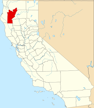
This is a list of the National Register of Historic Places listings in Trinity County, California.

<span class="mw-page-title-main">National Register of Historic Places listings in DeSoto County, Florida</span>

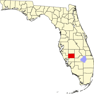
This is a detailed table of the district on the National Register of Historic Places in DeSoto County, Florida, United States. The location of the National Register district for which the latitude and longitude coordinates are included below, may be seen in a map.

<span class="mw-page-title-main">National Register of Historic Places listings in Franklin County, Florida</span>

This is a list of the National Register of Historic Places listings in Franklin County, Florida.

<span class="mw-page-title-main">National Register of Historic Places listings in Hamilton County, Florida</span>

This is a list of the National Register of Historic Places listings in Hamilton County, Florida.

<span class="mw-page-title-main">National Register of Historic Places listings in Hernando County, Florida</span>

This is a list of the National Register of Historic Places listings in Hernando County, Florida.

<span class="mw-page-title-main">National Register of Historic Places listings in Washington County, Florida</span>

This is a list of the National Register of Historic Places listings in Washington County, Florida.

<span class="mw-page-title-main">National Register of Historic Places listings in Natchitoches Parish, Louisiana</span>

This is a list of the National Register of Historic Places listings in Natchitoches Parish, Louisiana.

<span class="mw-page-title-main">National Register of Historic Places listings in St. Landry Parish, Louisiana</span>

This is a list of the National Register of Historic Places listings in St. Landry Parish, Louisiana.

<span class="mw-page-title-main">National Register of Historic Places listings in Marion County, South Carolina</span>

This is a list of the National Register of Historic Places listings in Marion County, South Carolina.

<span class="mw-page-title-main">National Register of Historic Places listings in McCormick County, South Carolina</span>

This is a list of the National Register of Historic Places listings in McCormick County, South Carolina.

<span class="mw-page-title-main">National Register of Historic Places listings in Wells County, Indiana</span>

This is a list of the National Register of Historic Places listings in Wells County, Indiana.

<span class="mw-page-title-main">National Register of Historic Places listings in Fayette County, Indiana</span>

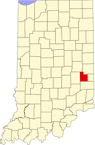
This is a list of the National Register of Historic Places listings in Fayette County, Indiana.

<span class="mw-page-title-main">National Register of Historic Places listings in Greene County, Indiana</span>

This is a list of the National Register of Historic Places listings in Greene County, Indiana.

<span class="mw-page-title-main">National Register of Historic Places listings in Spencer County, Indiana</span>

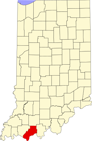
This is a list of the National Register of Historic Places listings in Spencer County, Indiana.

<span class="mw-page-title-main">National Register of Historic Places listings in Switzerland County, Indiana</span>

This is a list of the National Register of Historic Places listings in Switzerland County, Indiana.

<span class="mw-page-title-main">National Register of Historic Places listings in Benton County, Arkansas</span>

This is a list of the National Register of Historic Places listings in Benton County, Arkansas.

References

  1. "National Register Information System". National Register of Historic Places . National Park Service. July 9, 2010.
  2. "Weekly List of Actions Taken on Properties: 5/28/13 Through 5/31/13". National Register of Historic Places. National Park Service. Retrieved June 9, 2013.