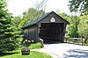
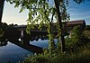
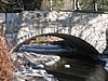
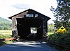
Name Image Built Listed Location County Type Ashuelot Covered Bridge ca. 1864 February 20, 1981 Ashuelot 42°46′35″N 72°25′26″W / 42.77639°N 72.42389°W / 42.77639; -72.42389 (Ashuelot Covered Bridge ) Cheshire Town lattice truss Bath Covered Bridge 1832 September 1, 1976 Bath 44°10′1″N 71°58′3″W / 44.16694°N 71.96750°W / 44.16694; -71.96750 (Bath Covered Bridge ) Grafton Burr truss Bedell Covered Bridge 1866 May 28, 1975 Haverhill 44°2′53″N 72°4′20″W / 44.04806°N 72.07222°W / 44.04806; -72.07222 (Bedell Covered Bridge ) Grafton Burr arch truss Bement Covered Bridge 1854 November 21, 1976 Bradford 43°15′51″N 71°57′13″W / 43.26417°N 71.95361°W / 43.26417; -71.95361 (Bement Covered Bridge ) Merrimack Blow-Me-Down Covered Bridge 1877 May 19, 1978 Plainfield 43°31′2″N 72°22′28″W / 43.51722°N 72.37444°W / 43.51722; -72.37444 (Blow-Me-Down Covered Bridge ) Sullivan Kingpost truss Bog Bridge 1887 March 16, 1989 Andover 43°25′49″N 71°52′11″W / 43.43028°N 71.86972°W / 43.43028; -71.86972 (Bog Bridge ) Merrimack Town through truss Carleton Bridge 1869 June 10, 1975 East Swanzey 42°51′14″N 72°16′28″W / 42.85389°N 72.27444°W / 42.85389; -72.27444 (Carleton Bridge ) Cheshire Queenpost truss Cold River Bridge 1869 May 17, 1973 Langdon 43°10′13″N 72°20′46″W / 43.17028°N 72.34611°W / 43.17028; -72.34611 (Cold River Bridge ) Sullivan Town lattice truss Columbia Covered Bridge 1912 December 12, 1976 Columbia 44°51′12″N 71°33′5″W / 44.85333°N 71.55139°W / 44.85333; -71.55139 (Columbia Covered Bridge ) Coos Howe truss Contoocook Railroad Bridge 1849, 1889, 1936 January 11, 1980 Contoocook 43°13′23″N 71°42′51″W / 43.22306°N 71.71417°W / 43.22306; -71.71417 (Contoocook Railroad Covered Bridge ) Merrimack Town pratt truss; crosses Contoocook River Coombs Covered Bridge 1837 November 21, 1976 Winchester 42°50′17″N 72°21′43″W / 42.83806°N 72.36194°W / 42.83806; -72.36194 (Coombs Covered Bridge ) Cheshire Town truss Cornish–Windsor Covered Bridge 1866 November 21, 1976 Cornish 43°28′26″N 72°23′1″W / 43.47389°N 72.38361°W / 43.47389; -72.38361 (Cornish-Windsor Covered Bridge ) Sullivan Town lattice truss County Farm Bridge 1885 May 14, 1981 Wilton 42°51′25″N 71°49′3″W / 42.85694°N 71.81750°W / 42.85694; -71.81750 (County Farm Bridge ) Hillsborough Stone arch County Farm Bridge ca. 1875 May 21, 1975 Dover 43°13′14″N 70°56′38″W / 43.22056°N 70.94389°W / 43.22056; -70.94389 (County Farm Bridge ) Strafford Howe truss Dalton Covered Bridge 1853 November 21, 1976 Warner 43°16′36″N 71°48′43″W / 43.27667°N 71.81194°W / 43.27667; -71.81194 (Dalton Covered Bridge ) Merrimack Panel truss Dingleton Hill Covered Bridge 1882, 1883 November 8, 1978 Cornish Mills 43°27′51″N 72°22′9″W / 43.46417°N 72.36917°W / 43.46417; -72.36917 (Dingleton Hill Covered Bridge ) Sullivan Kingpost truss Durgin Bridge 1869 September 22, 1983 Sandwich 43°51′21″N 71°21′53″W / 43.85583°N 71.36472°W / 43.85583; -71.36472 (Durgin Bridge ) Carroll Paddleford truss Gilsum Stone Arch Bridge 1863 August 31, 1989 Gilsum 43°2′20″N 72°16′14″W / 43.03889°N 72.27056°W / 43.03889; -72.27056 (Gilsum Stone Arch Bridge ) Cheshire Dry masonry stone arch Goffstown Covered Railroad Bridge 1901 June 18, 1975 Goffstown 43°1′4″N 71°35′58″W / 43.01778°N 71.59944°W / 43.01778; -71.59944 (Goffstown Covered Railroad Bridge ) Hillsborough Town pratt truss; destroyed by fire. Great Hollow Road Stone Arch Bridge 1914 May 12, 1997 Hanover 43°41′13″N 72°14′0″W / 43.68694°N 72.23333°W / 43.68694; -72.23333 (Great Hollow Road Stone Arch Bridge ) Grafton Stone arch Hancock–Greenfield Bridge 1937 May 5, 1981 Hancock 42°57′25″N 71°56′8″W / 42.95694°N 71.93556°W / 42.95694; -71.93556 (Hancock-Greenfield Bridge ) Hillsborough Teco pratt timber truss Haverhill–Bath Covered Bridge 1829 April 18, 1977 Woodsville 44°9′16″N 72°2′12″W / 44.15444°N 72.03667°W / 44.15444; -72.03667 (Haverhill-Bath Covered Bridge ) Grafton Town lattice truss Hillsborough Railroad Bridge 1903 June 10, 1975 Hillsborough 43°6′48″N 71°53′44″W / 43.11333°N 71.89556°W / 43.11333; -71.89556 (Hillsborough Railroad Bridge ) Hillsborough Town lattice truss; destroyed by fire. Keniston Bridge 1882 March 16, 1989 Andover 43°26′6″N 71°50′12″W / 43.43500°N 71.83667°W / 43.43500; -71.83667 (Keniston Bridge ) Merrimack Town through truss Kenyon Bridge 1882 May 22, 1978 Cornish City 43°28′0″N 72°21′3″W / 43.46667°N 72.35083°W / 43.46667; -72.35083 (Kenyon Bridge ) Sullivan Multiple kingpost truss Lyme–East Thetford Bridge 1937 March 27, 2020 Lyme 43°48′44″N 72°10′59″W / 43.812144°N 72.1831°W / 43.812144; -72.1831 (Lyme–East Thetford Bridge ) Grafton Parker truss Meadow Bridge 1897 December 10, 2003 Shelburne 44°24′5″N 71°3′49″W / 44.40139°N 71.06361°W / 44.40139; -71.06361 (Meadow Bridge ) Coos Multiple steel truss Meriden Bridge ca. 1880 August 27, 1980 Meriden 43°33′12″N 72°16′0″W / 43.55333°N 72.26667°W / 43.55333; -72.26667 (Meriden Bridge ) Sullivan Multiple kingpost truss Milford Suspension Bridge 1889 July 17, 2017 Milford 42°50′12″N 71°38′44″W / 42.83667°N 71.64556°W / 42.83667; -71.64556 (Milford Suspension Bridge ) Hillsborough Suspension bridge Mount Orne Covered Bridge 1911 December 12, 1976 Lancaster 44°27′38″N 71°39′12″W / 44.46056°N 71.65333°W / 44.46056; -71.65333 (Mount Orne Covered Bridge ) Coos Howe truss Pier Bridge 1907 June 10, 1975 Newport 43°21′43″N 72°14′31″W / 43.36194°N 72.24194°W / 43.36194; -72.24194 (Pier Bridge ) Sullivan Town lattice truss Piermont Bridge 1928 June 6, 2001 Piermont 43°58′40″N 72°6′45″W / 43.97778°N 72.11250°W / 43.97778; -72.11250 (Piermont Bridge ) Grafton Pennsylvania through truss Pineground Bridge 1887 March 10, 2004 Chichester 43°15′26″N 71°22′12″W / 43.25722°N 71.37000°W / 43.25722; -71.37000 (Pineground Bridge ) Merrimack Lenticular through truss Prentiss Bridge ca. 1874 May 24, 1973 Langdon 43°9′11″N 72°23′38″W / 43.15306°N 72.39389°W / 43.15306; -72.39389 (Prentiss Bridge ) Sullivan Town lattice truss Rowell's Covered Bridge 1852, 1853 November 21, 1976 West Hopkinton 43°11′30″N 71°45′40″W / 43.19167°N 71.76111°W / 43.19167; -71.76111 (Rowell's Covered Bridge ) Merrimack Long patent truss;Burr arch Samuel Morey Memorial Bridge 1936, 1938 December 8, 1997 Orford 43°54′25″N 72°8′23″W / 43.90694°N 72.13972°W / 43.90694; -72.13972 (Samuel Morey Memorial Bridge ) Grafton Steel arch Sawyers Crossing Covered Bridge 1859 November 14, 1978 Swanzey 42°53′8″N 72°17′0″W / 42.88556°N 72.28333°W / 42.88556; -72.28333 (Sawyers Crossing Covered Bridge ) Cheshire Town truss Slate Covered Bridge 1862 November 14, 1978 Westport 42°50′51″N 72°20′29″W / 42.84750°N 72.34139°W / 42.84750; -72.34139 (Slate Covered Bridge ) Cheshire Town lattice truss Stark Covered Bridge ca. 1857 December 1, 1980 Groveton 44°36′3″N 71°24′30″W / 44.60083°N 71.40833°W / 44.60083; -71.40833 (Stark Covered Bridge ) Coos Paddleford truss Stone Arch Bridge 1847 August 12, 2012 Keene 45°54′51″N 72°15′11″W / 45.91417°N 72.25306°W / 45.91417; -72.25306 (Stone Arch Bridge ) Cheshire Stone Arch Underpass 1848 September 12, 1985 Lebanon 43°38′3″N 72°18′21″W / 43.63417°N 72.30583°W / 43.63417; -72.30583 (Stone Arch Underpass ) Grafton Sulphite Railroad Bridge 1897 June 11, 1975 Franklin 43°26′43″N 71°38′10″W / 43.44528°N 71.63611°W / 43.44528; -71.63611 (Sulphite Railroad Bridge ) Merrimack Pratt truss Swiftwater Covered Bridge 1849 November 21, 1976 Bath 44°8′3″N 71°57′5″W / 44.13417°N 71.95139°W / 44.13417; -71.95139 (Swiftwater Covered Bridge ) Grafton Paddleford truss Tilton Island Park Bridge 1858, 1881 March 21, 1980 Tilton 43°26′32″N 71°35′13″W / 43.44222°N 71.58694°W / 43.44222; -71.58694 (Tilton Island Park Bridge ) Belknap Truesdell truss Waterloo Covered Bridge 1859, 1860 November 21, 1976 Waterloo 43°17′16″N 71°51′27″W / 43.28778°N 71.85750°W / 43.28778; -71.85750 (Waterloo Covered Bridge ) Merrimack Town lattice truss West Swanzey Covered Bridge 1832 February 29, 1980 West Swanzey 42°52′18″N 72°19′42″W / 42.87167°N 72.32833°W / 42.87167; -72.32833 (West Swanzey Covered Bridge ) Cheshire Town truss Whittier Bridge ca. 1870 March 15, 1984 Ossipee 43°49′13″N 71°11′59″W / 43.82028°N 71.19972°W / 43.82028; -71.19972 (Whittier Bridge ) Carroll Paddleford truss Wright's Bridge 1906 June 10, 1975 Newport 43°21′33″N 72°15′34″W / 43.35917°N 72.25944°W / 43.35917; -72.25944 (Wright's Bridge ) Sullivan Town lattice truss