Woodsville, New Hampshire

Last updated

Woodsville, New Hampshire
Court Square, Woodsville, NH.jpg
Bird's-eye view in 1908
USA New Hampshire location map.svg
Red pog.svg
Woodsville
Usa edcp location map.svg
Red pog.svg
Woodsville
Coordinates: 44°9′08″N72°2′13″W / 44.15222°N 72.03694°W / 44.15222; -72.03694
Country United States
State New Hampshire
County Grafton
Town Haverhill
Area
[1]
  Total1.88 sq mi (4.86 km2)
  Land1.85 sq mi (4.79 km2)
  Water0.03 sq mi (0.07 km2)
Elevation
456 ft (139 m)
Population
 (2020)
  Total1,431
  Density773.51/sq mi (298.68/km2)
Time zone UTC-5 (Eastern (EST))
  Summer (DST) UTC-4 (EDT)
ZIP code
03785
Area code 603
FIPS code 33-87140
GNIS feature ID0870998

Woodsville is a census-designated place (CDP) and the largest village in the town of Haverhill in Grafton County, New Hampshire, United States, along the Connecticut River at the mouth of the Ammonoosuc River. The population was 1,431 at the 2020 census. [2] Although North Haverhill is now the county seat of Grafton County, [3] the village of Woodsville has traditionally been considered the county seat, as the county courthouse was originally located there. The county buildings are now located halfway between Woodsville and the village of North Haverhill to the south.

Contents

History

Woodsville on US302 Woodsville NH US302.jpg
Woodsville on US302

Woodsville was named for John L. Woods, a figure in its early development. He arrived from Wells River, Vermont, a village across the Connecticut River narrows in Newbury, and in 1829 purchased a sawmill which had been operating on the Ammonoosuc River since 1811. He manufactured pine lumber, and opened a store in his house. [4] Spring snowmelt carried log drives down the Connecticut and Ammonoosuc rivers. A log boom was built across the Connecticut River to Wells River to hold the logs briefly for sorting. Logs not destined for Woods' mill were released gradually to avoid jams in the Ox Bow meadow downstream. Log drivers detailed to work at the boom enjoyed Woodsville's saloons and red-light district. [5]

The Boston, Concord & Montreal Railroad opened at Woodsville in 1853 and built its division offices and a branch repair shop. It replaced the original 1805 bridge between the states with a two-level span, featuring a toll highway below and railroad tracks on the roof. [6] The village boomed into an important railway town and junction, endowed with fine examples of Victorian architecture. It also became a center for legal affairs. The log drives were stopped after 1915, when pleasure boat owners complained about the hazards to navigation. [7] In 1889, the Grafton County Court moved from Haverhill Corner to Woodsville, where it remained until moving halfway to North Haverhill in 1972. [8]

Geography

Woodsville is in the northwest corner of the town of Haverhill, bordered to the north by the town of Bath and to the west by the Connecticut River, which forms the state border with Vermont. According to the United States Census Bureau, the CDP has a total area of 1.9 square miles (4.9 km2), of which 1.9 square miles (4.8 km2) are land and 0.04 square miles (0.1 km2), or 1.46%, are water. [9] The Ammonoosuc River runs just north of the CDP and reaches its confluence with the Connecticut River at the northernmost point in the community.

Woodsville is crossed by U.S. Route 302 and by state routes 10 and 135. US 302 leads northeast 21 miles (34 km) to Littleton and west across the Connecticut River to Wells River, Vermont, and 3 miles (5 km) to Interstate 91. Route 10 leads south from Woodsville 37 miles (60 km) to Hanover, and Route 135 leads north 20 miles (32 km) to Interstate 93 northwest of Littleton.

Woodsville serves as the commercial center for the town of Haverhill and the surrounding communities, including several just to the west in Vermont. Many of the town's commercial businesses, including supermarkets, sit-down and fast-food restaurants, and banks, are located near the junction of US 302 and NH 10. Cottage Hospital, a critical-access hospital serving the area, is also located in Woodsville.

Demographics

Historical population
CensusPop.Note
1950 1,542
1960 1,5963.5%
1970 1,336−16.3%
1980 1,195−10.6%
1990 1,122−6.1%
2000 1,081−3.7%
2010 1,1264.2%
2020 1,43127.1%
U.S. Decennial Census [10]
Free Public Library in 1907 Witcher Library, Woodsville, NH.jpg
Free Public Library in 1907

As of the census of 2010, there were 1,126 people, 482 households, and 293 families residing in the CDP. There were 558 housing units, of which 76, or 13.6%, were vacant. The racial makeup of the CDP was 96.5% white, 0.2% African American, 0.5% Native American, 1.5% Asian, 0.1% Pacific Islander, 0.3% some other race, and 1.9% from two or more races. 1.2% of the population were Hispanic or Latino of any race. [11]

Of the 482 households in the CDP, 30.7% had children under the age of 18 living with them, 41.1% were headed by married couples living together, 15.4% had a female householder with no husband present, and 39.2% were non-families. 31.7% of all households were made up of individuals, and 9.8% were someone living alone who was 65 years of age or older. The average household size was 2.34, and the average family size was 2.87. [11]

The Parker House and the Hotel Wentworth c. 1908 Parker House and Hotel Wentworth, Woodsville, NH.jpg
The Parker House and the Hotel Wentworth c. 1908

23.9% of residents in the CDP were under the age of 18, 9.4% were from age 18 to 24, 26.3% were from 25 to 44, 28.1% ere from 45 to 64, and 12.3% were 65 years of age or older. The median age was 38.0 years. For every 100 females, there were 92.5 males. For every 100 females age 18 and over, there were 87.5 males. [11]

For the period 2011–15, the estimated median annual income for a household was $40,708, and the median income for a family was $34,635. The per capita income for the CDP was $14,945. About 28.4% of the population and 20.3% of families were below the poverty line, including 40.1% of those under age 18. [12]

Notable people

In The Stand by Stephen King, Woodsville is mentioned as the home of Glen Pequod Bateman, a major character in the novel. He was an associate professor of sociology at the fictional Woodsville Community College when the superflu hit.[ citation needed ]

See also

Related Research Articles

<span class="mw-page-title-main">Grafton County, New Hampshire</span> County in New Hampshire, United States

Grafton County is a county in the U.S. state of New Hampshire. As of the 2020 census, the population was 91,118. Its county seat is the town of Haverhill. In 1972, the county courthouse and other offices were moved from Woodsville, a larger village within the town of Haverhill, to North Haverhill.

<span class="mw-page-title-main">Groveton, New Hampshire</span> Census-designated place in New Hampshire, United States

Groveton is a census-designated place (CDP) and the primary village in the town of Northumberland in Coos County, New Hampshire, United States. The population was 1,068 at the 2020 census. It is located at the intersection of U.S. Route 3 and New Hampshire Route 110.

<span class="mw-page-title-main">Bath, New Hampshire</span> Town in New Hampshire, United States

Bath is a town in Grafton County, New Hampshire, United States. The population was 1,077 at the 2020 census, unchanged from the 2010 census. Now a tourist destination and commuter town for Littleton, the town is noted for its historic architecture, including the Brick Store and three covered bridges. Bath includes the village of Swiftwater and part of the district known as Mountain Lakes.

<span class="mw-page-title-main">Bethlehem, New Hampshire</span> Town in New Hampshire, United States

Bethlehem is a hillside town in Grafton County, New Hampshire, United States. The population was 2,484 at the 2020 census. It is home to Cushman and Strawberry Hill state forests. The eastern half of the town is within the White Mountain National Forest. The Appalachian Trail crosses a small portion of the town in the south.

<span class="mw-page-title-main">Easton, New Hampshire</span> Town in New Hampshire, United States

Easton is a town in Grafton County, New Hampshire, United States. The population was 292 at the 2020 census.

<span class="mw-page-title-main">Haverhill, New Hampshire</span> Town in New Hampshire, United States

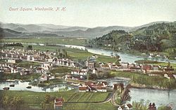
Haverhill is a town and the seat of Grafton County, New Hampshire, United States. The population was 4,585 at the 2020 census. Haverhill includes the villages of Woodsville, Pike, and North Haverhill, the historic town center at Haverhill Corner, and the district of Mountain Lakes. Located here are Bedell Bridge State Park, Black Mountain State Forest, Kinder Memorial Forest, and Oliverian Valley Wildlife Preserve. It is home to the annual North Haverhill Fair, and to a branch of the New Hampshire Community Technical Colleges.

<span class="mw-page-title-main">Lyman, New Hampshire</span> Town in New Hampshire, United States

Lyman is a town in Grafton County, New Hampshire, United States. The population was 585 at the 2020 census.

<span class="mw-page-title-main">Monroe, New Hampshire</span> Town in New Hampshire, United States

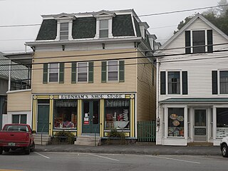
Monroe is a town in Grafton County, New Hampshire, United States. The population was 864 at the 2020 census, up from 788 at the 2010 census. The town is located along the Connecticut River, across from Barnet, Vermont. It was originally chartered as part of Lyman.

<span class="mw-page-title-main">Piermont, New Hampshire</span> Town in New Hampshire, United States

Piermont is a town in Grafton County, New Hampshire, United States. The population was 769 at the 2020 census. It is home to Camp Walt Whitman and Kingswood Camp for Boys.

<span class="mw-page-title-main">Groton, Vermont</span> Town in Vermont, United States

Groton is a town in Caledonia County, Vermont, United States. The population was 984 at the 2020 census. It contains the places Groton Pond, Rickers Mills, Rickers and West Groton. The unincorporated village of Groton in the southeast corner of town is recorded as the Groton census-designated place (CDP), with a population of 419 at the 2020 census.

<span class="mw-page-title-main">Wells River, Vermont</span> Village in Vermont, United States

Wells River is a village in the town of Newbury in Orange County, Vermont, United States. The population was 431 at the 2020 census. The village center is located at the junction of U.S. Routes 5 and 302.

Lisbon is a census-designated place (CDP) and the main village in the town of Lisbon in Grafton County, New Hampshire, United States. The population of the CDP was 965 at the 2020 census, out of 1,621 in the entire town.

<span class="mw-page-title-main">Lisbon, New Hampshire</span> Town in New Hampshire, United States

Lisbon is a town in Grafton County, New Hampshire, United States. The population was 1,621 at the 2020 census. Lisbon hosts an annual lilac festival on Memorial Day weekend.

Littleton is a census-designated place (CDP) and the main village in the town of Littleton in Grafton County, New Hampshire, United States. The population of the CDP was 4,467 at the 2020 census, out of 6,005 in the entire town.

<span class="mw-page-title-main">Littleton, New Hampshire</span> Town in New Hampshire, United States

Littleton is a town in Grafton County, New Hampshire, United States. The population was 6,005 at the 2020 census. Situated at the northern edge of the White Mountains, Littleton is bounded on the northwest by the Connecticut River.

<span class="mw-page-title-main">U.S. Route 302</span> Numbered Highway in the US states of Vermont, New Hampshire, and Maine

U.S. Route 302 is an east–west spur of U.S. Route 2 in northern New England in the United States. It currently runs 171 miles (275 km) from Montpelier, Vermont, beginning at US 2, to Portland, Maine, at U.S. Route 1. It passes through the states of Vermont, New Hampshire and Maine.

<span class="mw-page-title-main">New Hampshire Route 10</span> North-south state highway in New Hampshire, US

New Hampshire Route 10 is a 122.25-mile-long (196.74 km) north–south state highway in western New Hampshire, United States. Its southern terminus is in Winchester at the Massachusetts state line, where it continues south as Massachusetts Route 10. Administratively, the northern terminus is at a junction with U.S. Route 302 in Haverhill.

<span class="mw-page-title-main">North Haverhill, New Hampshire</span> Census-designated place in New Hampshire, United States

North Haverhill is an unincorporated community and census-designated place (CDP) in Haverhill, New Hampshire, United States. It is one of several villages in the town of Haverhill. As of the 2020 census, North Haverhill had a population of 843.

Mountain Lakes is a census-designated place (CDP) in the towns of Haverhill and Bath in Grafton County, New Hampshire, United States. It had a population of 504 at the 2020 census.

<span class="mw-page-title-main">North Walpole, New Hampshire</span> Census-designated place in New Hampshire, United States

North Walpole is a census-designated place (CDP) in the town of Walpole in Cheshire County, New Hampshire, United States. It had a population of 785 at the 2020 census, making it the largest village in the town of Walpole.

References

  1. "ArcGIS REST Services Directory". United States Census Bureau. Retrieved September 20, 2022.
  2. "Woodsville CDP, New Hampshire: 2020 DEC Redistricting Data (PL 94-171)". U.S. Census Bureau. Retrieved December 1, 2021.
  3. "Find a County". National Association of Counties. Retrieved June 7, 2011.
  4. Hamilton Child, Gazetteer of Grafton County, N.H.; Syracuse, New York 1886
  5. Holbrook, Stewart H. (1961). Yankee Loggers. International Paper Company. p. 68.
  6. "River Heritage".
  7. Wheeler, Scott (September 2002). The History of Logging in Vermont's Northeast Kingdom. The Kingdom Historical.
  8. Katherine Blaisdell, "The Grafton County Seat;" Outlook Magazine 1983
  9. "2021 U.S. Gazetteer Files – New Hampshire". United States Census Bureau. Retrieved December 1, 2021.
  10. "Decennial Census Official Publications". Census.gov. Retrieved March 4, 2024.
  11. 1 2 3 "Profile of General Population and Housing Characteristics: 2010 Census Summary File 1 (DP-1): Woodsville CDP, New Hampshire". U.S. Census Bureau, American Factfinder. Archived from the original on February 13, 2020. Retrieved October 16, 2017.
  12. "Selected Economic Characteristics: 2011-2015 American Community Survey 5-Year Estimates (DP03): Woodsville CDP, New Hampshire". U.S. Census Bureau, American Factfinder. Archived from the original on February 13, 2020. Retrieved October 16, 2017.
  13. "My Kind of Town". National Review . September 20, 2011.