Waterville Valley, New Hampshire

Last updated

Waterville Valley, New Hampshire
Town
Waterville Valley Town Square, Village Rd, New Hampshire - panoramio.jpg
Waterville Valley Town Square
Motto: 
"The Town at the End of the Road"
Grafton-Waterville-Valley-NH.svg
Coordinates: 43°57′23″N71°30′31″W / 43.95639°N 71.50861°W / 43.95639; -71.50861
Country United States
State New Hampshire
County Grafton
Incorporated 1829
Government
   Select Board
  • Richard Rita, Chair
  • Robert Fries
  • Wendi Rathgeber
  Town ManagerMark Decoteau
Area
[1]
  Total64.4 sq mi (166.9 km2)
  Land64.3 sq mi (166.6 km2)
  Water0.1 sq mi (0.3 km2)  0.20%
Elevation
1,506 ft (459 m)
Population
 (2020) [2]
  Total508
  Density8/sq mi (3.0/km2)
Time zone UTC−5 (Eastern)
  Summer (DST) UTC−4 (Eastern)
ZIP Code
03215
Area code 603
FIPS code 33-79380
GNIS feature ID0873748
Website www.watervillevalley.org

Waterville Valley is a New England town in Grafton County, New Hampshire, United States. The population was 508 at the 2020 census, [2] up from 247 at the 2010 census. [3]

Contents

It is a resort town which attracts many visitors in the winter months with alpine skiing at Waterville Valley Resort and many miles of trails for cross-country skiing. During the summer, attractions include a golf course, tennis courts, and a variety of hiking options. The Mad River flows through the town, providing great views all year round.

History

The area was first settled in the 1760s, and incorporated as "Waterville" in 1829. The name "Waterville Valley" was adopted in 1967. [4]

Geography

According to the United States Census Bureau, the town has a total area of 64.4 square miles (166.9 km2), of which 64.3 square miles (166.6 km2) are land and 0.1 square miles (0.3 km2) are water, comprising 0.20% of the town. [1] The central part of the town is drained by the Mad River, which flows southwest toward the Pemigewasset River, part of the Merrimack River watershed. The southeastern section of town is drained by the Whiteface and Wonalancet rivers, southward-flowing tributaries of the Bearcamp River and part of the Saco River watershed. The northeastern part of the town is drained by the Swift River, another tributary of the Saco.

The highest point in Waterville Valley is the North Peak of Mount Tripyramid, at 4,180 feet (1,270 m) above sea level. Other 4000-footers in the town include Mount Tecumseh in the west (formerly listed as 4,003 feet (1,220 m) but recently revised to 3,997 feet (1,218 m)), and Mounts Whiteface (4,019 feet/1,225 m) and Passaconaway (4,043 feet/1,232 m) in the east. 3,983-foot (1,214 m) Sandwich Mountain is on the southern border.

Climate

According to the Köppen Climate Classification system, Waterville Valley has a warm-summer humid continental climate, abbreviated "Dfb" on climate maps.

Climate data for Waterville Valley, New Hampshire, 1991–2020 normals
MonthJanFebMarAprMayJunJulAugSepOctNovDecYear
Mean daily maximum °F (°C)27.7
(−2.4)
30.1
(−1.1)
37.6
(3.1)
50.4
(10.2)
63.1
(17.3)
71.7
(22.1)
77.2
(25.1)
75.9
(24.4)
69.4
(20.8)
55.7
(13.2)
43.3
(6.3)
33.3
(0.7)
53.0
(11.6)
Daily mean °F (°C)16.7
(−8.5)
18.1
(−7.7)
26.5
(−3.1)
39.5
(4.2)
51.4
(10.8)
60.6
(15.9)
65.6
(18.7)
64.0
(17.8)
57.0
(13.9)
45.1
(7.3)
34.2
(1.2)
23.8
(−4.6)
41.9
(5.5)
Mean daily minimum °F (°C)5.7
(−14.6)
6.1
(−14.4)
15.4
(−9.2)
28.5
(−1.9)
39.6
(4.2)
49.4
(9.7)
54.1
(12.3)
52.0
(11.1)
44.6
(7.0)
34.4
(1.3)
25.1
(−3.8)
14.4
(−9.8)
30.8
(−0.7)
Average precipitation inches (mm)3.91
(99)
3.25
(83)
4.30
(109)
4.64
(118)
4.16
(106)
5.16
(131)
4.79
(122)
4.35
(110)
4.18
(106)
5.62
(143)
4.48
(114)
4.98
(126)
53.82
(1,367)
Source: NOAA [5]

Demographics

Historical population
CensusPop.Note
1830 96
1840 63−34.4%
1850 42−33.3%
1860 4814.3%
1870 33−31.2%
1880 5463.6%
1890 39−27.8%
1900 5028.2%
1910 16−68.0%
1920 95493.8%
1930 23−75.8%
1940 2613.0%
1950 11−57.7%
1960 1427.3%
1970 109678.6%
1980 18065.1%
1990 151−16.1%
2000 25770.2%
2010 247−3.9%
2020 508105.7%
U.S. Decennial Census [2] [6]

As of the census [7] of 2000, there were 257 people, 121 households, and 75 families residing in the town. The population density was 4.0 people per square mile (1.5/km2). There were 1,097 housing units at an average density of 16.9 per square mile (6.5/km2). The racial makeup of the town was 97.28% White, 1.95% Asian, 0.78% from other races. Hispanic or Latino of any race were 1.56% of the population.

There were 121 households, out of which 27.3% had children under the age of 18 living with them, 45.5% were married couples living together, 9.1% had a female householder with no husband present, and 38.0% were non-families. 34.7% of all households were made up of individuals, and 6.6% had someone living alone who was 65 years of age or older. The average household size was 2.12 and the average family size was 2.72.

In the town, the population was spread out, with 22.2% under the age of 18, 6.6% from 18 to 24, 20.6% from 25 to 44, 37.0% from 45 to 64, and 13.6% who were 65 years of age or older. The median age was 45 years. For every 100 females, there were 104.0 males. For every 100 females age 18 and over, there were 108.3 males.

The median income for a household in the town was $40,417, and the median income for a family was $55,625. Males had a median income of $34,167 versus $34,063 for females. The per capita income for the town was $26,400. About 6.8% of families and 6.2% of the population were below the poverty line, including 6.7% of those under the age of eighteen and none of those 65 or over.

Education

The Waterville Valley Elementary School is also known as the "Little Red School" and had 41 students enrolled in kindergarten through 8th grade for the 2011–2012 school year. The children at the school are able to bike, swim, ski, skate, and play tennis in Waterville Valley. There is a recreation department attached to the "Little Red School".

The Waterville Valley Academy (WVA) is a ski academy, founded in 1972. [8] The campus is located at 88 Boulder Path Rd, at the foot of Snow's Mountain. It has around 160 students and is part of the WVBBTS ski club, the oldest ski club in America. In 2013, the school expanded its academic programming and began to offer a full-year program known as the Pinnacle Program. [9]

Culture

Since 1994, Waterville Valley has hosted the Russell Sage Foundation Summer Institute in Behavioral Economics (BE). [10] 2016 Economics Nobel Laureate Richard Thaler describes the institute as an important driver of the early growth of behavioral economics. [11]

Notable people

Related Research Articles

<span class="mw-page-title-main">Lincoln, New Hampshire</span> Town in New Hampshire, United States

Lincoln is a town in Grafton County, New Hampshire, United States. It is the second-largest town by area in New Hampshire. The population was 1,631 at the 2020 census. The town is home to the New Hampshire Highland Games and to a portion of Franconia Notch State Park. Set in the White Mountains, large portions of the town are within the White Mountain National Forest. The Appalachian Trail crosses the western and northeastern parts of the town. Lincoln is the location of Loon Mountain Ski Resort and associated recreation-centered development.

<span class="mw-page-title-main">Baldwin, Maine</span> Town in the state of Maine, United States

Baldwin is a town in Cumberland County, Maine, United States. The population was 1,520 at the 2020 census. It is part of the Portland–South Portland–Biddeford, Maine, metropolitan statistical area.

<span class="mw-page-title-main">Brownfield, Maine</span> Town in the state of Maine, United States

Brownfield is a town in Oxford County, Maine, United States. The population was 1,631 at the 2020 census. Brownfield is home to the Stone Mountain Arts Center.

<span class="mw-page-title-main">Hiram, Maine</span> Town in the state of Maine, United States

Hiram is a town in Oxford County, Maine, United States. The population was 1,609 at the 2020 census. It includes the villages of Hiram, East Hiram, South Hiram and Durgintown. Located among the rugged and unspoiled Western Maine Mountains, Hiram is part of the Portland-South Portland-Biddeford, Maine metropolitan New England city and town area.

<span class="mw-page-title-main">Cornish, Maine</span> Town in the state of Maine, United States

Cornish is a town in York County, Maine, United States. The population was 1,508 at the 2020 census. It is part of the Portland–South Portland–Biddeford, Maine metropolitan statistical area. The main village in town is the Cornish census-designated place. The village has a number of antique shops and restaurants near historic Thompson Park. Cornish is home to the first concrete bridge in North America.

<span class="mw-page-title-main">Gilford, New Hampshire</span> Town in New Hampshire, United States

Gilford is a town in Belknap County, New Hampshire, United States. The population was 7,699 at the 2020 census, up from 7,126 at the 2010 census. Situated on Lake Winnipesaukee, Gilford is home to Governors Island, Ellacoya State Beach, Belknap Mountain State Forest, Gunstock Mountain Resort, and the Bank of New Hampshire Pavilion, a seasonal outdoor concert venue. The lakeside village of Glendale lies within Gilford's borders.

<span class="mw-page-title-main">Albany, New Hampshire</span> Town in New Hampshire, United States

Albany is a town in Carroll County, New Hampshire, United States. The population was 759 at the 2020 census.

<span class="mw-page-title-main">Bartlett, New Hampshire</span> Town in New Hampshire, United States

Bartlett is a town in Carroll County, New Hampshire, United States. The population was 3,200 at the 2020 census, up from 2,788 at the 2010 census. Bartlett includes the unincorporated community of Glen as well as portions of the communities of Kearsarge and Intervale, which the town shares with the neighboring town of Conway. It is set in the White Mountains and is surrounded by the White Mountain National Forest. It is home to the Attitash Mountain Resort and the Story Land theme park.

<span class="mw-page-title-main">Freedom, New Hampshire</span> Town in New Hampshire, United States

Freedom is a town located in Carroll County, New Hampshire, United States. The population was 1,689 at the 2020 census, up from 1,489 at the 2010 census. The town's eastern boundary runs along the Maine state border. Ossipee Lake, with a resort and camps, is in the southwest of the town.

<span class="mw-page-title-main">Jackson, New Hampshire</span> Town in New Hampshire, United States

Jackson is a town in Carroll County, New Hampshire, United States. The population was 1,028 at the 2020 census, up from 816 at the 2010 census. Jackson is a resort area in the White Mountains. Parts of the White Mountain National Forest are in the west, north and east.

<span class="mw-page-title-main">Madison, New Hampshire</span> Town in New Hampshire, United States

Madison is a town in Carroll County, New Hampshire, United States. The population was 2,565 at the 2020 census. Madison includes the village of Silver Lake and the village district of Eidelweiss.

<span class="mw-page-title-main">North Conway, New Hampshire</span> Census-designated place in New Hampshire, United States

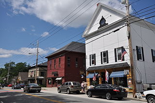
North Conway is a census-designated place (CDP) and village in eastern Carroll County, New Hampshire, United States. The population was 2,116 at the 2020 census. A year-round resort area, North Conway is the second-largest village within the town of Conway, after the village of Conway proper. North Conway maintains its own fire station, post office and public library, sharing its other services with Conway. The White Mountain National Forest is to the west and north. The area is home to Cathedral Ledge, Echo Lake State Park, and Cranmore Mountain Resort. North Conway is known for its large number of outlet shops.

<span class="mw-page-title-main">Sandwich, New Hampshire</span> Town in New Hampshire, United States

Sandwich is a town in Carroll County, New Hampshire, United States. Its population was 1,466 at the 2020 census. Sandwich includes the villages of Center Sandwich and North Sandwich. Part of the White Mountain National Forest is in the north, and part of Squam Lake is in the southwestern corner of the town. As such, Sandwich lies on the boundary between New Hampshire's Lakes Region and White Mountains Region. The Sandwich Range of the White Mountains lies partially within the town, as does the namesake Sandwich Mountain. The town is home to the Sandwich Fair, a popular agricultural fair that occurs every October.

<span class="mw-page-title-main">Carroll, New Hampshire</span> Town in New Hampshire, United States

Carroll is a town in Coös County, New Hampshire, United States. The population was 820 at the 2020 census. The two largest villages are Twin Mountain and Bretton Woods. Carroll is an important access point for recreational areas in the White Mountains, including many 4,000-footers, the Zealand River area, the Presidential Range, and the Presidential Dry River Wilderness. The town is home to the Mount Washington Hotel at Bretton Woods and to the Highland Center at Crawford Notch, the Appalachian Mountain Club's four-season lodge.

<span class="mw-page-title-main">Sugar Hill, New Hampshire</span> Town in New Hampshire, United States

Sugar Hill is a town in Grafton County, New Hampshire, United States. The population was 647 at the 2020 census, an increase over the figure of 563 tabulated in 2010. The town overlooks the White Mountain National Forest, with views of the Presidential, Franconia, Kinsman and Dalton ranges. Sugar Hill was incorporated as a town in 1962, the most recent in New Hampshire.

<span class="mw-page-title-main">Thornton, New Hampshire</span> Town in New Hampshire, United States

Thornton is a town in Grafton County, New Hampshire, United States. The population was 2,708 at the 2020 census, up from 2,490 at the 2010 census.

<span class="mw-page-title-main">Bennington, New Hampshire</span> Town in New Hampshire, United States

Bennington is a town in Hillsborough County, New Hampshire, United States. The population was 1,501 at the 2020 census.

<span class="mw-page-title-main">Newbury, New Hampshire</span> Town in New Hampshire, United States

Newbury is a town in Merrimack County, New Hampshire, United States. The population was 2,172 at the 2020 census.

<span class="mw-page-title-main">Wilmington, New York</span> Town in New York, United States

Wilmington is a town in Essex County, New York, United States. The population was 1,253 at the 2010 census. The town is named after the nearby town of Wilmington, Vermont.

<span class="mw-page-title-main">Conway, New Hampshire</span> Town in New Hampshire, United States

Conway is a town in Carroll County, New Hampshire, United States. It is the most populous community in the county, with a population of 9,822 at the 2020 census, down from 10,115 at the 2010 census. The town is on the southeastern edge of the White Mountain National Forest. There are five villages in the town: Conway, North Conway, Center Conway, Redstone and Kearsarge. Additionally, it shares a portion of the village of Intervale with the neighboring town of Bartlett.

References

  1. 1 2 "2021 U.S. Gazetteer Files – New Hampshire". United States Census Bureau. Retrieved November 30, 2021.
  2. 1 2 3 "Waterville Valley town, Grafton County, New Hampshire: 2020 DEC Redistricting Data (PL 94-171)". U.S. Census Bureau. Retrieved November 30, 2021.
  3. United States Census Bureau, U.S. Census website, 2010 Census figures. Retrieved March 23, 2011.
  4. "Town of Waterville Valley with a capital T | Waterville Valley Real Estate – New Hampshire Real Estate in Waterville Valley". www.wvnh.com. Retrieved November 23, 2018.
  5. "U.S. Climate Normals Quick Access – Station: Waterville Valley NEPP, NH". National Oceanic and Atmospheric Administration. Retrieved March 28, 2023.
  6. "Census of Population and Housing". Census.gov. Retrieved June 4, 2016.
  7. "U.S. Census website". United States Census Bureau . Retrieved January 31, 2008.
  8. "Waterville Valley Academy".
  9. Tracy, Paula (August 28, 2013). "Program in Waterville Valley holds classes for skiers, snowboarders". WMUR. Retrieved October 18, 2021.
  10. "Russell Sage Foundation".
  11. Thaler, Richard (May 7, 2015). Misbehaving: The Making of Behavioral Economics. W. W. Norton & Company. ISBN   978-0393352795.