Waterford, Vermont

Last updated

Waterford, Vermont
Moore Reservoir.JPG
Waterford seen across Moore Reservoir
Waterford vt highlight.png
Waterford, Vermont
Usa edcp location map.svg
Red pog.svg
Waterford, Vermont
Location in the United States
Coordinates: 44°22′N71°57′W / 44.367°N 71.950°W / 44.367; -71.950
Country United States
State Vermont
County Caledonia
CharteredNovember 8, 1780, [1]
Communities Lower Waterford
West Waterford
Area
  Total39.7 sq mi (102.9 km2)
  Land38.3 sq mi (99.2 km2)
  Water1.4 sq mi (3.7 km2)
Elevation
1,306 ft (398 m)
Population
 (2020)
  Total1,268
  Density33/sq mi (12.8/km2)
Time zone UTC−5 (Eastern (EST))
  Summer (DST) UTC−4 (EDT)
ZIP Code
05819
Area code 802
FIPS code 50-77125 [2]
GNIS feature ID1462245 [3]

Waterford is a town in Caledonia County, Vermont, United States. The population was 1,268 at the 2020 census. [4]

Contents

History

The town was formed by the Vermont charter on November 8, 1780, [1] and was originally called Littleton, but the name was changed to Waterford in 1797. [5] The town may have been named after Waterford, Ireland, or for the ford that ran across the Connecticut River in that area. [1]

Geography

Waterford is in eastern Caledonia County on the Connecticut River, the eastern border of Vermont. The town is bordered by Barnet to the west, St. Johnsbury to the northwest, Kirby to the north, and Concord, Vermont, to the east. The town of Littleton, New Hampshire, is to the south, across the Connecticut River.

According to the United States Census Bureau, the town of Waterford has an area of 39.7 square miles (102.9 km2), of which 38.3 square miles (99.2 km2) is land and 1.4 square miles (3.7 km2), or 3.59%, is water. [6]

The town is crossed by Interstate 93 and Interstate 91. The northern terminus of I-93, at I-91, is in the western corner of the town, just south of St. Johnsbury. Exit 1 on I-93 serves the northern part of Waterford. Vermont Route 18 is a two-lane highway that parallels I-93.

The highest point in Waterford is the 2,017-foot (615 m) summit of Fuller Hill, near the town's eastern border. [7]

Demographics

Historical population
CensusPop.Note
1790 63
1800 565796.8%
1810 1,289128.1%
1820 1,247−3.3%
1830 1,3588.9%
1840 1,3882.2%
1850 1,4121.7%
1860 1,171−17.1%
1870 879−24.9%
1880 815−7.3%
1890 734−9.9%
1900 705−4.0%
1910 629−10.8%
1920 574−8.7%
1930 71224.0%
1940 498−30.1%
1950 468−6.0%
1960 460−1.7%
1970 58627.4%
1980 88250.5%
1990 1,19034.9%
2000 1,104−7.2%
2010 1,28015.9%
2020 1,268−0.9%
U.S. Decennial Census [8]

At the 2000 census there were 1,104 people in 424 households, including 340 families, in the town. The population density was 28.9 people per square mile (11.2/km2). There were 477 housing units at an average density of 12.5 per square mile (4.8/km2). The racial makeup of the town was 98.55% White, 0.27% Asian, and 1.18% from two or more races. Hispanic or Latino of any race were 0.27%. [2]

Of the 424 households 32.1% had children under the age of 18 living with them, 71.7% were married couples living together, 5.4% had a female householder with no husband present, and 19.8% were non-families. 15.8% of households were one person and 6.1% were one person aged 65 or older. The average household size was 2.60 and the average family size was 2.88.

The age distribution was 24.6% under the age of 18, 4.3% from 18 to 24, 25.7% from 25 to 44, 31.4% from 45 to 64, and 13.9% 65 or older. The median age was 42 years. For every 100 females, there were 104.4 males. For every 100 females age 18 and over, there were 100.5 males.

Arts and culture

The area known as "White Village" features homes from the 1700s, a church, library, post office and bed and breakfast. [9]

Economy

Personal income

The median household income was $50,197 and the median family income was $52,105. Males had a median income of $32,100 versus $23,839 for females. The per capita income for the town was $21,762. About 2.3% of families and 4.2% of the population were below the poverty line, including 3.3% of those under age 18 and 6.3% of those age 65 or over.

Waterford has the highest per capita income of any town or city in the Northeast Kingdom. It ranks 74 out of 282 census areas in Vermont. [10]

Education

Waterford Public Schools are part of the Caledonia Central Supervisory Union. The district serves students in prekindergarten to eighth grade. [11]

Notable people

The film State and Main is about a film production; it is set in Waterford, although it was actually filmed in Massachusetts.

Related Research Articles

<span class="mw-page-title-main">Caledonia County, Vermont</span> County in Vermont, United States

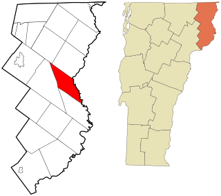
Caledonia County is a county located in the northeastern part of the U.S. state of Vermont. As of the 2020 census, the population was 30,233. Its shire town is the town of St. Johnsbury. The county was created in 1792 and organized in 1796. It was given the Latin name for Scotland, in honor of the many settlers who claimed ancestry there.

<span class="mw-page-title-main">Piermont, New Hampshire</span> Town in New Hampshire, United States

Piermont is a town in Grafton County, New Hampshire, United States. The population was 769 at the 2020 census. It is home to Camp Walt Whitman and Kingswood Camp for Boys.

<span class="mw-page-title-main">Barnet, Vermont</span> Town in Vermont, United States

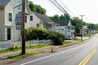
Barnet is a town in Caledonia County, Vermont, United States. The population was 1,663 at the 2020 census. Barnet contains the locations of Barnet Center, East Barnet, McIndoe Falls, Mosquitoville, Passumpsic and West Barnet. The main settlement of Barnet is recorded as a census-designated place by the U.S. Census Bureau, with a population of 127 at the 2020 census.

<span class="mw-page-title-main">Danville, Vermont</span> Town in Vermont, United States

Danville is a town in Caledonia County, Vermont, United States. The population was 2,335 at the 2020 census. The primary settlement in town is recorded as the Danville census-designated place (CDP) and had a population of 385 at the 2020 census.

<span class="mw-page-title-main">Groton, Vermont</span> Town in Vermont, United States

Groton is a town in Caledonia County, Vermont, United States. The population was 984 at the 2020 census. It contains the places Groton Pond, Rickers Mills, Rickers and West Groton. The unincorporated village of Groton in the southeast corner of town is recorded as the Groton census-designated place (CDP), with a population of 419 at the 2020 census.

<span class="mw-page-title-main">Kirby, Vermont</span> Town in Vermont, United States

Kirby is a town in Caledonia County, Vermont, United States. The population was 575 at the 2020 census.

<span class="mw-page-title-main">Lyndon, Vermont</span> Town in Vermont, United States

Lyndon is a town in Caledonia County, Vermont, United States. As of the 2020 census, the population was 5,491. Lyndon is the home of Lyndon State College. The town contains five unincorporated villages, Lyndonville just east of the geographic center of town, Lyndon Corner in the south, Lyndon Center in the center of town on the west side of Lyndonville, Little Egypt in the north, and East Lyndon in the southeast.

<span class="mw-page-title-main">Ryegate, Vermont</span> Town in Vermont, United States

Ryegate is a town in Caledonia County, Vermont, United States. The population was 1,165 at the 2020 census. The town contains the villages of South Ryegate, East Ryegate, and Ryegate Corner.

<span class="mw-page-title-main">Sheffield, Vermont</span> Town in Vermont, United States

Sheffield is a town in Caledonia County, Vermont, United States. The population was 682 at the 2020 census.

<span class="mw-page-title-main">Stannard, Vermont</span> Town in Vermont, United States

Stannard is a town in Caledonia County, Vermont. The population was 208 at the 2020 census. The town has no paved roads.

<span class="mw-page-title-main">Walden, Vermont</span> Town in Vermont, United States

Walden is a town in Caledonia County, Vermont, United States. The population was 956 at the 2020 census. The community has no ZIP code of its own; mail is routed through the West Danville and East Hardwick post offices.

<span class="mw-page-title-main">Wheelock, Vermont</span> Town in Vermont, United States

Wheelock is a town in Caledonia County, Vermont, United States. The population was 759 at the 2020 census.

<span class="mw-page-title-main">Brunswick, Vermont</span> Town in Vermont, United States

Brunswick is a town in Essex County, Vermont, United States. The town was named after Prince Karl Wilhelm Ferdinand of Brunswick-Lunenburg. The population was 88 at the 2020 census. It is part of the Berlin, NH-VT Micropolitan Statistical Area. Brunswick is home to six mineral springs that made the town a popular resort destination in the 19th century. The land the springs are on is now owned by the Abenaki people.

<span class="mw-page-title-main">Concord, Vermont</span> Town in Vermont, United States

Concord is a town in Essex County, Vermont, United States. The population was 1,141 at the 2020 census. It is part of the Berlin, NH–VT Micropolitan Statistical Area.

<span class="mw-page-title-main">Guildhall, Vermont</span> Town in Vermont, United States

Guildhall is a town in and the shire town of Essex County, Vermont, United States. As of the 2020 census, the population was 262. According to a large sign in the town center, it is the only town in the world so named. The name derives from a meeting house on the square called the Guildhall.

<span class="mw-page-title-main">Lemington, Vermont</span> Town in Vermont, United States

Lemington is a town in Essex County, Vermont, United States. The population was 87 as of the 2020 census. It is part of the Berlin, NH–VT Micropolitan Statistical Area.

<span class="mw-page-title-main">Lunenburg, Vermont</span> Town in Vermont, United States

Lunenburg is a town in Essex County, Vermont, United States. The population was 1,246 at the 2020 census, the most populous in Essex County. Lunenburg contains the villages of Lunenburg and Gilman and hamlets of West Lunenburg, South Lunenburg, and Mill Village, and is part of the Berlin, NH–VT Micropolitan Statistical Area.

Lancaster is a census-designated place (CDP) and the main village in the town of Lancaster in Coos County, New Hampshire, United States. The population of the CDP was 1,941 at the 2020 census, out of 3,218 in the entire town of Lancaster.

Littleton is a census-designated place (CDP) and the main village in the town of Littleton in Grafton County, New Hampshire, United States. The population of the CDP was 4,467 at the 2020 census, out of 6,005 in the entire town.

<span class="mw-page-title-main">St. Johnsbury, Vermont</span> Town in Vermont, United States

St. Johnsbury is the shire town of Caledonia County, Vermont, United States. As of the 2020 census, the population was 7,364. St. Johnsbury is situated on the Passumpsic River and is located approximately six miles northwest of the Connecticut River and 48 miles (77 km) south of the Canada–U.S. border.

References

  1. 1 2 3 "About Waterford, Vermont". Virtual Vermont. Retrieved December 30, 2012.
  2. 1 2 "U.S. Census website". United States Census Bureau . Retrieved January 31, 2008.
  3. "US Board on Geographic Names". United States Geological Survey. October 25, 2007. Retrieved January 31, 2008.
  4. "Census - Geography Profile: Waterford town, Caledonia County, Vermont". United States Census Bureau . Retrieved January 7, 2022.
  5. Land Grants for Towns of Vermont Starting with W -- Waterford
  6. "Geographic Identifiers: 2010 Demographic Profile Data (G001): Waterford town, Caledonia County, Vermont". U.S. Census Bureau, American Factfinder. Archived from the original on February 12, 2020. Retrieved February 6, 2013.
  7. U.S. Geological Survey Concord, VT 7.5-minute quadrangle, 1967.
  8. "U.S. Decennial Census". United States Census Bureau. Retrieved May 16, 2015.
  9. "Waterford, Vermont 05848". Vermont Living Magazine. Retrieved December 30, 2012.
  10. Vermont locations by per capita income
  11. "Essex-Caledonia Supervisory Union, Homepage".
  12. "A Political Sage: Amos K. Hadley an Old Warrior at 85". The Eagle (Bryan, TX). March 12, 1898. p. 2.
  13. "ROSS, Jonathan, (1826 - 1905)". Biographical Directory of the United States Congress. Retrieved December 30, 2012.