Millers Falls, Massachusetts

Last updated

Millers Falls, Massachusetts
Millers Falls, Birdseye View 1.jpg
Bird's-eye view in 1907
Franklin County Massachusetts incorporated and unincorporated areas Millers Falls highlighted.svg
Location in Franklin County in Massachusetts
Coordinates: 42°34′45″N72°29′36″W / 42.57917°N 72.49333°W / 42.57917; -72.49333
Country United States
State Massachusetts
County Franklin
Town Montague
Area
[1]
  Total0.96 sq mi (2.48 km2)
  Land0.91 sq mi (2.36 km2)
  Water0.05 sq mi (0.12 km2)
Elevation
[2]
295 ft (90 m)
Population
 (2020)
  Total994
  Density1,088.72/sq mi (420.56/km2)
Time zone UTC-5 (Eastern (EST))
  Summer (DST) UTC-4 (EDT)
ZIP code
01349
Area code 413
FIPS code 25-41410
GNIS feature ID0609184 [2]

Millers Falls is a census-designated place (CDP) in the towns of Montague and Erving in Franklin County, Massachusetts, United States. The population was 1,139 at the 2010 census. [3] It is part of the Springfield, Massachusetts metropolitan statistical area.

Contents

History

Lithograph of Miller's Falls from 1889 by L.R. Burleigh with list of landmarks Millers Falls, Mass. (2673688725).jpg
Lithograph of Miller's Falls from 1889 by L.R. Burleigh with list of landmarks

Located along the Mohawk Trail, Millers Falls was first established in 1824 as an agricultural community, named Grout's Corner after first settler Martin Grout (1790–1865). In the 1860s, however, the local growth of railroads stimulated development, as the New London Northern Railroad bought the Amherst & Palmer railroad in 1864 and in 1866 extended its line to a connection with the Vermont & Massachusetts at Grout's Corner. With this new railroad juncture, the abundant water power of the falls at Grout's Corner provided a perfect place to establish mills. The village's present name derives from the Millers Falls Manufacturing Company (later the Millers Falls Company), established on the Millers River in 1868, and famed for its fine hand tools.

The central portion of the village was listed on the National Register of Historic Places in 2021. [4]

Geography

Millers Falls is located at 42°34′45″N72°29′36″W / 42.57917°N 72.49333°W / 42.57917; -72.49333 (42.579154, -72.493414), [5] near the border with Erving, Massachusetts.

According to the United States Census Bureau, the CDP has a total area of 2.4 km2 (0.9 mi²), of which 2.3 km2 (0.9 mi²) is land and 0.1 km2 (0.04 mi²) (3.26%) is water. The village is drained by the Millers River, a tributary of the Connecticut River.

Millers Falls is crossed by Massachusetts Routes 2 and 63.

Demographics

Historical population
CensusPop.Note
2020 994
U.S. Decennial Census [6]

At the 2000 census there were 1,072 people, 439 households, and 273 families living in the CDP. The population density was 465.1/km2 (1,198.1/mi²). There were 472 housing units at an average density of 204.8/km2 (527.5/mi²). The racial makeup of the CDP was 96.18% White, 0.28% African American, 1.03% Native American, 0.37% Asian, 0.09% from other races, and 2.05% from two or more races. Hispanic or Latino of any race were 1.12%. [7]

Of the 439 households 31.0% had children under the age of 18 living with them, 43.3% were married couples living together, 11.8% had a female householder with no husband present, and 37.8% were non-families. 27.3% of households were one person and 13.0% were one person aged 65 or older. The average household size was 2.44 and the average family size was 2.95.

The age distribution was 22.9% under the age of 18, 9.6% from 18 to 24, 34.7% from 25 to 44, 19.2% from 45 to 64, and 13.5% 65 or older. The median age was 35 years. For every 100 females, there were 100.0 males. For every 100 females age 18 and over, there were 97.6 males.

The median household income was $37,337 and the median family income was $41,711. Males had a median income of $34,886 versus $24,375 for females. The per capita income for the CDP was $17,768. About 1.8% of families and 4.8% of the population were below the poverty line, including 4.8% of those under age 18 and 9.0% of those age 65 or over.

Related Research Articles

<span class="mw-page-title-main">Erving, Massachusetts</span> Town in Massachusetts, United States

Erving is a town in Franklin County, Massachusetts, United States. The population was 1,665 at the 2020 census. It is part of the Springfield, Massachusetts metropolitan statistical area.

<span class="mw-page-title-main">Turners Falls, Massachusetts</span> Census-designated place in Massachusetts, United States

Turners Falls is an unincorporated village and census-designated place in the town of Montague in Franklin County, Massachusetts, United States. The population was 4,512 at the 2020 census. It is part of the Springfield, Massachusetts Metropolitan Statistical Area. Its name is sometimes used as a metonym for the entire town of Montague, for which it is the business district and comprises more than half the population.

<span class="mw-page-title-main">Amherst Center, Massachusetts</span> Census-designated place in Massachusetts, United States

Amherst Center is a census-designated place (CDP) in the City of Amherst in Hampshire County, Massachusetts, United States. The CDP covers the primary village in town. The population was 19,065 at the 2010 census, out of a total town population of 37,819. It is part of the Springfield, Massachusetts Metropolitan Statistical Area.

<span class="mw-page-title-main">North Amherst, Massachusetts</span> Census-designated place in Massachusetts, United States

North Amherst is a census-designated place (CDP) in the city of Amherst in Hampshire County, Massachusetts, United States. The population was 6,819 at the 2010 census, up from 6,019 at the 2000 census. It is part of the Springfield, Massachusetts Metropolitan Statistical Area.

<span class="mw-page-title-main">South Amherst, Massachusetts</span> Census-designated place in Massachusetts, United States

South Amherst is a census-designated place (CDP) in the town of Amherst in Hampshire County, Massachusetts, United States. The population was 4,994 at the 2010 census. The CDP includes the village of South Amherst and residential subdivisions south of the Amherst town center.

<span class="mw-page-title-main">North Pembroke, Massachusetts</span> Census-designated place in Massachusetts, United States

North Pembroke is a census-designated place (CDP) in the town of Pembroke in Plymouth County, Massachusetts, United States. The population was 3,292 at the 2010 census.

<span class="mw-page-title-main">Baldwinville, Massachusetts</span> CDP in Massachusetts, United States

Baldwinville is an unincorporated village and census-designated place (CDP) in the town of Templeton in Worcester County, Massachusetts, United States. The population was 2,028 at the 2010 census. The name also refers to the local post office or railroad station.

<span class="mw-page-title-main">Fiskdale, Massachusetts</span> CDP in Sturbridge, Massachusetts, United States

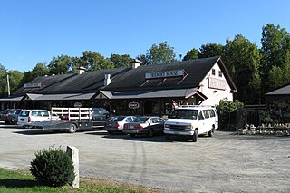
Fiskdale is a census-designated place (CDP) in the town of Sturbridge in Worcester County, Massachusetts, United States. The population was 2,583 at the 2010 census.

<span class="mw-page-title-main">Hunter, Ohio</span> CDP in Ohio, United States

Hunter is a census-designated place (CDP) in Franklin Township, Warren County, Ohio, United States. The population was 3,363 at the 2020 census.

<span class="mw-page-title-main">Bondsville, Massachusetts</span>

Bondsville is an area and former census-designated place (CDP) located in the town of Palmer in Hampden County in the western part of the U.S. state of Massachusetts. The population of the CDP was 1,876 at the 2000 census. It is part of the Springfield, Massachusetts Metropolitan Statistical Area. The village was named after Emelius Bond who first secured the water rights of the Swift River in 1846 to form the Bond Village Manufacturing Company.

<span class="mw-page-title-main">Orange (CDP), Massachusetts</span> Census-designated place in Massachusetts, United States

Orange is a census-designated place (CDP) in the town of Orange in Franklin County, Massachusetts, United States. The population was 4,018 at the 2010 census. It is part of the Springfield, Massachusetts Metropolitan Statistical Area.

<span class="mw-page-title-main">Palmer (CDP), Massachusetts</span> Former CDP in Massachusetts, United States

Palmer is former census-designated place (CDP) in Hampden County, Massachusetts, United States. The population was 3,900 at the 2000 census. It is part of the Springfield, Massachusetts Metropolitan Statistical Area. The area is more commonly known as Depot Village, named for the ornate train depot built there by famed architect H.H. Richardson

<span class="mw-page-title-main">Granby (CDP), Massachusetts</span> Census-designated place in Massachusetts, United States

Granby is a census-designated place (CDP) comprising the main village in the town of Granby in Hampshire County, Massachusetts, United States. The population of the CDP was 1,368 at the 2010 census, out of a total town population of 6,240. It is part of the Springfield, Massachusetts Metropolitan Statistical Area.

<span class="mw-page-title-main">Hatfield (CDP), Massachusetts</span> Census-designated place in Massachusetts, United States

Hatfield is a census-designated place (CDP) comprising the main village in the town of Hatfield in Hampshire County, Massachusetts, United States. The population of the CDP was 1,318 at the 2010 census, out of a total town population of 3,279. It is part of the Springfield, Massachusetts Metropolitan Statistical Area.

<span class="mw-page-title-main">Athol (CDP), Massachusetts</span> CDP in Massachusetts, United States

Athol is a census-designated place (CDP) in the town of Athol in Worcester County, Massachusetts, United States. The population was 8,265 at the 2010 census.

<span class="mw-page-title-main">Barre (CDP), Massachusetts</span> CDP in Massachusetts, United States

Barre is a census-designated place (CDP) in the town of Barre in Worcester County, Massachusetts, United States. The population was 1,009 at the 2010 census.

<span class="mw-page-title-main">East Brookfield (CDP), Massachusetts</span> CDP in Massachusetts, United States

East Brookfield is a census-designated place (CDP) in the town of East Brookfield in Worcester County, Massachusetts, United States. The population was 1,323 at the 2010 census.

<span class="mw-page-title-main">Sturbridge (CDP), Massachusetts</span> CDP in Massachusetts, United States

Sturbridge is a census-designated place (CDP) in the town of Sturbridge in Worcester County, Massachusetts, United States. The population was 2,253 at the 2010 census.

<span class="mw-page-title-main">Warren (CDP), Massachusetts</span> CDP in Massachusetts, United States

Warren is a census-designated place (CDP) in the town of Warren in Worcester County, Massachusetts, United States. The population was 1,405 at the 2010 census.

<span class="mw-page-title-main">Winchendon (CDP), Massachusetts</span> Census-designated place in Massachusetts, United States

Winchendon is a census-designated place (CDP) in the town of Winchendon in Worcester County, Massachusetts, United States. The population was 4,213 at the 2010 census.

References

  1. "2020 U.S. Gazetteer Files". United States Census Bureau. Retrieved May 21, 2022.
  2. 1 2 U.S. Geological Survey Geographic Names Information System: Millers Falls, Massachusetts
  3. "Profile of General Population and Housing Characteristics: 2010 Demographic Profile Data (DP-1): Millers Falls CDP, Massachusetts". United States Census Bureau . Retrieved August 29, 2012.
  4. "Weekly listing". National Park Service.
  5. "US Gazetteer files: 2010, 2000, and 1990". United States Census Bureau. February 12, 2011. Retrieved April 23, 2011.
  6. "Census of Population and Housing". Census.gov. Retrieved June 4, 2016.
  7. "U.S. Census website". United States Census Bureau . Retrieved January 31, 2008.