Hartford, Vermont

Last updated

Hartford, Vermont
HartfordVT VillageHD 2.jpg
Hartford, Vermont
Interactive map outlining Hartford
Windsor County Vermont incorporated and unincorporated areas Hartford highlighted.svg
Location in Windsor County and the state of Vermont.
Usa edcp location map.svg
Red pog.svg
Hartford, Vermont
Location in the United States
Coordinates: 43°39′54″N72°22′18″W / 43.66500°N 72.37167°W / 43.66500; -72.37167
CountryUnited States
State Vermont
County Windsor
Chartered1761 [1]
Area
  Total45.9 sq mi (118.9 km2)
  Land45.0 sq mi (116.5 km2)
  Water0.9 sq mi (2.3 km2)
Elevation
761 ft (232 m)
Population
 (2020)
  Total10,686
  Density230/sq mi (90/km2)
Time zone UTC−5 (Eastern (EST))
  Summer (DST) UTC−4 (EDT)
ZIP code
05047
Area code 802
FIPS code 50-32275 [2]
GNIS feature ID1462116 [3]
Website www.hartford-vt.org

Hartford is a town in Windsor County, Vermont, United States. It is on the New Hampshire border, at the intersection of Interstates 89 and 91. It is the site of the confluence of the White and Connecticut rivers; the Ottauquechee River also flows through the town. [4] The town is composed of five unincorporated villages: Hartford, Quechee, West Hartford, White River Junction and Wilder. As of the 2020 census, the population was 10,686. [5]

Contents

History

The community was chartered by Governor Benning Wentworth of New Hampshire in 1761, [1] and is named for Hartford, Connecticut. [6] [7]

On February 5, 1887, Hartford became the site of what remains Vermont's worst railway disaster when a Vermont Central Railroad train struck a broken rail on a bridge west of town. The ensuing derailment threw the train to the frozen river below, killing 37 and injuring 50. [8]

Geography

The town of Hartford is located at 43°39′52″N72°23′12″W / 43.66444°N 72.38667°W / 43.66444; -72.38667 (43.66444, 72.38667). [9]

According to the United States Census Bureau, the town has a total area of 45.9 square miles (118.9 km2), of which 45.0 square miles (116.5 km2) is land and 0.89 square miles (2.3 km2), or 1.93%, is water. [10] The Appalachian Trail crosses the northwest corner of the town, passing through West Hartford.

Demographics

Historical population
CensusPop.Note
1790 988
1800 1,49451.2%
1810 1,88125.9%
1820 2,0106.9%
1830 2,0441.7%
1840 2,1947.3%
1850 2,159−1.6%
1860 2,39611.0%
1870 2,4803.5%
1880 2,95419.1%
1890 3,74026.6%
1900 3,8172.1%
1910 4,19710.0%
1920 4,73912.9%
1930 4,8883.1%
1940 4,9781.8%
1950 5,82717.1%
1960 6,3559.1%
1970 6,4771.9%
1980 7,96322.9%
1990 9,40418.1%
2000 10,36710.2%
2010 9,952−4.0%
2020 10,6867.4%
U.S. Decennial Census [11]

At the 2000 census there were 10,367 people in 4,509 households, including 2,800 families, in the town. The population density was 229.6 people per square mile (88.7/km2). There were 5,493 housing units at an average density of 121.7 per square mile (47.0/km2). The racial makeup of the town was 97.02% White, 0.55% African American, 0.31% Native American, 0.88% Asian, 0.03% Pacific Islander, 0.16% from other races, and 1.05% from two or more races. Hispanic or Latino of any race were 0.85%. [2]

Of the 4,509 households 28.7% had children under the age of 18 living with them, 48.8% were married couples living together, 10.2% had a female householder with no husband present, and 37.9% were non-families. 30.6% of households were one person and 10.9% were one person aged 65 or older. The average household size was 2.28 and the average family size was 2.86.

The age distribution was 23.4% under the age of 18, 5.9% from 18 to 24, 29.3% from 25 to 44, 26.7% from 45 to 64, and 14.7% 65 or older. The median age was 40 years. For every 100 females, there were 89.9 males. For every 100 females age 18 and over, there were 86.9 males.

The median household income was $42,990 and the median family income was $51,286. Males had a median income of $35,969 versus $27,073 for females. The per capita income for the town was $22,792. About 5.3% of families and 8.5% of the population were below the poverty line, including 8.8% of those under age 18 and 4.9% of those age 65 or over.

Notable people

Related Research Articles

<span class="mw-page-title-main">Windsor County, Vermont</span> County in Vermont, United States

Windsor County is a county located in the U.S. state of Vermont. As of the 2020 census, the population was 57,753. The shire town is the town of Woodstock. The county's largest municipality is the town of Hartford.

<span class="mw-page-title-main">Bennington County, Vermont</span> County in Vermont, United States

Bennington County is a county in the U.S. state of Vermont. As of the 2020 census, the population was 37,347. The shire towns are jointly Bennington and Manchester, and the largest municipality is Bennington. The county was created in 1778.

<span class="mw-page-title-main">Salisbury, Vermont</span> Town in Vermont, United States

Salisbury is a town in Addison County, Vermont, United States. The population was 1,221 at the 2020 census.

<span class="mw-page-title-main">Readsboro, Vermont</span> Town in Vermont, United States

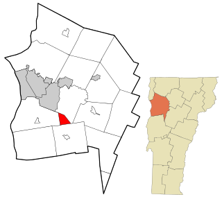
Readsboro is a town in Bennington County, Vermont, United States. The town was named after John Reade, a landholder. The population was 702 at the 2020 census. The hamlet of Heartwellville is in the northern part of Readsboro, approximately 5 miles (8 km) north on Route 100 from the hamlet of Readsboro.

<span class="mw-page-title-main">Waterford, Vermont</span> Town in Vermont, United States

Waterford is a town in Caledonia County, Vermont, United States. The population was 1,268 at the 2020 census.

<span class="mw-page-title-main">St. George, Vermont</span> Town in Vermont, United States

St. George is a town in Chittenden County, Vermont, United States. The town was named for the patron saint of England. St. George has the smallest land area of any town in Vermont, though the incorporated cities of St. Albans, Vergennes, and Winooski are smaller. The population was 794 at the 2020 census.

<span class="mw-page-title-main">Brunswick, Vermont</span> Town in Vermont, United States

Brunswick is a town in Essex County, Vermont, United States. The town was named after Prince Karl Wilhelm Ferdinand of Brunswick-Lunenburg. The population was 88 at the 2020 census. It is part of the Berlin, NH–VT Micropolitan Statistical Area. Brunswick is home to six mineral springs that made the town a popular resort destination in the 19th century. The land the springs are on is now owned by the Abenaki people.

<span class="mw-page-title-main">Ferdinand, Vermont</span> Town in Vermont, United States

Ferdinand is a town in Essex County, Vermont, United States. It was named after German Prince Karl Wilhelm Ferdinand of Brunswick-Lunenburg. Although incorporated, it was never formally organized since it never gained a sufficiently large permanent population. Its population was 16 at the 2020 census and was highest in 1910, with 213. It is managed by the Unified Towns & Gores of Essex County. It is part of the Berlin, NH–VT Micropolitan Statistical Area.

<span class="mw-page-title-main">Granby, Vermont</span> Town in Vermont, United States

Granby is a town in Essex County, Vermont, United States. The town was named for the Marquis of Granby. The population was 81 at the 2020 census. Granby is part of the Berlin, NH–VT Micropolitan Statistical Area. Granby was one of the last two towns in Vermont to be linked to the electric grid, in 1963.

<span class="mw-page-title-main">Lunenburg, Vermont</span> Town in Vermont, United States

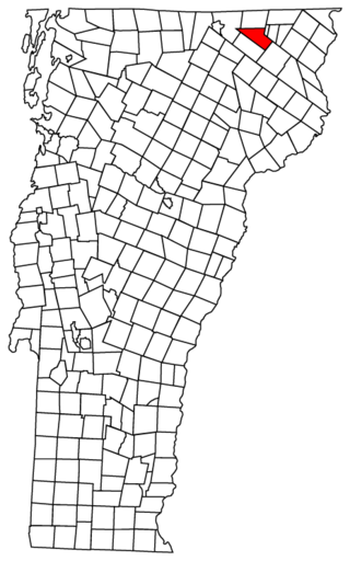
Lunenburg is a town in Essex County, Vermont, United States. The population was 1,246 at the 2020 census, the most populous in Essex County. Lunenburg contains the villages of Lunenburg and Gilman and hamlets of West Lunenburg, South Lunenburg, and Mill Village, and is part of the Berlin, NH–VT Micropolitan Statistical Area.

<span class="mw-page-title-main">Wolcott, Vermont</span> Town in Vermont, United States

Wolcott is a town in Lamoille County, Vermont, United States. The town was named for General Oliver Wolcott, a signer of the Declaration of Independence. The population was 1,670 at the 2020 census.

<span class="mw-page-title-main">Morgan, Vermont</span> Town in Vermont, United States

Morgan is the easternmost town in Orleans County, Vermont, United States. The population was 638 at the 2020 census. The town contains two villages: Morgan and Morgan Center.

<span class="mw-page-title-main">Waitsfield, Vermont</span> Town in Vermont, United States

Waitsfield is a town in Washington County, Vermont, United States. The population was 1,844 as of the 2020 census. It was created by a Vermont charter on February 25, 1782, and was granted to militia Generals Benjamin Wait, Roger Enos and others. The town was named after Wait.

<span class="mw-page-title-main">Pomfret, Vermont</span> Town in Vermont, United States

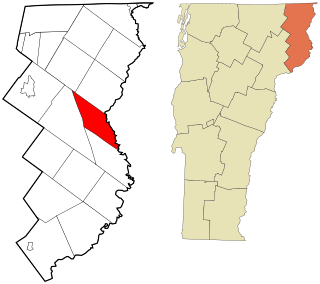
Pomfret is a town in Windsor County, Vermont, United States. The population was 916 at the 2020 census.

<span class="mw-page-title-main">Stockbridge, Vermont</span> Town in Vermont, United States

Stockbridge is a town in Windsor County, Vermont, United States, which contains the village of Gaysville. The population was 718 at the 2020 census. Stockbridge was one of thirteen Vermont towns isolated by flooding caused by Hurricane Irene in 2011.

<span class="mw-page-title-main">West Windsor, Vermont</span> Town in Vermont, United States

West Windsor is a town in Windsor County, Vermont, United States. The population was 1,344 at the 2020 census. It was known for its Ascutney Mountain Resort, which closed in 2010 and was bought by its citizens in 2015.

<span class="mw-page-title-main">Weston, Vermont</span> Town in Vermont, United States

Weston is a town in Windsor County, Vermont, United States. The population was 623 at the 2020 census. Home to the Weston Playhouse Theatre Company, it includes the villages of Weston and The Island.

<span class="mw-page-title-main">White River Junction, Vermont</span> Census-designated place in Vermont, United States

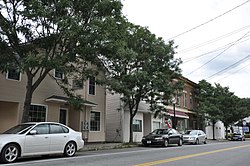
White River Junction is an unincorporated village and census-designated place (CDP) in the town of Hartford in Windsor County, Vermont, United States. The population was 2,528 at the 2020 census, up from 2,286 in 2010, making it the largest community within the town of Hartford.

<span class="mw-page-title-main">Windsor, Vermont</span> Town in Vermont, United States

Windsor is a town in Windsor County, Vermont, United States. As the "Birthplace of Vermont", the town is where the Constitution of Vermont was adopted in 1777, thus marking the founding of the Vermont Republic, a sovereign state until 1791, when Vermont joined the United States. Over much of its history, Windsor was home to a variety of manufacturing enterprises. Its population was 3,559 at the 2020 census.

<span class="mw-page-title-main">Hyde Park (town), Vermont</span> Town in Vermont, United States

Hyde Park is a town in and the shire town of Lamoille County, Vermont, United States. The town was named for Captain Jedediah Hyde, an early landowner who was a veteran of the American Revolutionary War. The population was 3,020 at the 2020 census. There is also a village of the same name within the town.

References

  1. 1 2 "Town of Hartford Vermont". Town of Hartford Vermont. Archived from the original on August 19, 2012. Retrieved October 27, 2012.
  2. 1 2 "U.S. Census website". United States Census Bureau . Retrieved January 31, 2008.
  3. "US Board on Geographic Names". United States Geological Survey. October 25, 2007. Retrieved January 31, 2008.
  4. DeLorme (1996). Vermont Atlas & Gazetteer. Yarmouth, Maine: DeLorme. ISBN   0-89933-016-9
  5. "Census - Geography Profile: Hartford town, Windsor County, Vermont". United States Census Bureau . Retrieved December 30, 2021.
  6. "Profile for Hartford, Vermont, VT". ePodunk. Retrieved October 27, 2012.
  7. Gannett, Henry (1905). The Origin of Certain Place Names in the United States. Govt. Print. Off. pp.  151.
  8. Ferguson, J. A. (2013). "The Wrong Rail in the Wrong Place at the Wrong Time: The 1887 West Hartford Bridge Disaster" (PDF). Vermont Historiy Journal. 81 (1): 52–74. Retrieved October 28, 2020.
  9. "US Gazetteer files: 2010, 2000, and 1990". United States Census Bureau. February 12, 2011. Retrieved April 23, 2011.
  10. "Geographic Identifiers: 2010 Demographic Profile Data (G001): Hartford town, Windsor County, Vermont". United States Census Bureau . Retrieved July 31, 2012.
  11. "U.S. Decennial Census". United States Census Bureau. Retrieved May 16, 2015.
  12. Hiram Carleton, Genealogical and Family History of the State of Vermont, 1903, pages 216-217
  13. Minnesota State Law Library-Daniel A. Dickinson Archived 2014-01-05 at the Wayback Machine
  14. The Blue Book of the State of Wisconsin. 1893. p. 640.
  15. "Phillips Lord". IMDb. Retrieved October 27, 2012.
  16. "Obituary, Frank Gordon Mahady" . Burlington Free Press. Burlington, VT. August 19, 1992. p. 12.
  17. Ullery, Jacob G. (1894). Men of Vermont Illustrated. Brattleboro, VT: Transcript Publishing Company. pp.  322–323.
  18. "STRONG, William, (1763-1840)". Biographical Directory of the United States Congress. Retrieved October 27, 2012.
  19. "Tracy, Andrew, (1797-1868)". Biographical Directory of the United States Congress. Retrieved October 27, 2012.