
Rindge is a town in Cheshire County, New Hampshire, United States. The population was 6,476 at the 2020 census, up from 6,014 at the 2010 census. Rindge is home to Franklin Pierce University, the Cathedral of the Pines and part of Annett State Forest.

Lake Winnipesaukee is the largest lake in the U.S. state of New Hampshire, located in the Lakes Region at the foothills of the White Mountains. It is approximately 21 miles (34 km) long (northwest-southeast) and from 1 to 9 miles wide (northeast-southwest), covering 69 square miles (179 km2)—71 square miles (184 km2) when Paugus Bay is included—with a maximum depth of 180 feet (55 m). The center area of the lake is called The Broads.

Winchendon, nicknamed Toy Town, is a town in Worcester County, Massachusetts, United States. The population was 10,364 at the 2020 census. The town includes the villages of Waterville and Winchendon Springs. A census-designated place, also named Winchendon, is defined within the town for statistical purposes. The Winchendon State Forest, a 174.5 acres parcel, is located within the township as is Otter River State Forest; both recreational areas are managed by the Massachusetts Department of Conservation and Recreation.

The Connecticut Lakes are a group of lakes in Coos County, northern New Hampshire, United States, situated along the headwaters of the Connecticut River. They are accessed via the northernmost segment of U.S. Route 3, between the village of Pittsburg and the Canada port of entry south of Chartierville, Quebec. The lakes are located within the boundaries of Pittsburg, but are far from the town center. Connecticut Lakes State Forest adjoins them.
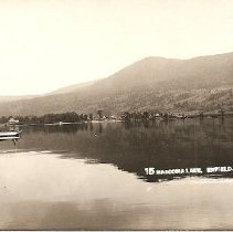
Mascoma Lake is a 1,158-acre (469 ha) lake in western New Hampshire, United States. Most of the lake is within the town of Enfield, while a small portion is within the city of Lebanon, where it drains into the Mascoma River, a tributary of the Connecticut River.
Lake Winnisquam is in Belknap County in the Lakes Region of central New Hampshire, United States, in the communities of Meredith, Laconia, Sanbornton, Belmont, and Tilton. At 4,214 acres (1,705 ha), it is the fourth-largest lake entirely in New Hampshire. The lake is roughly triangular in shape, with the vertexes pointing north, east, and south. The lake lies along the path of the Winnipesaukee River, which enters the lake from its eastern corner and carries water from Lake Winnipesaukee via Paugus Bay and Opechee Bay. The river also flows south out of Winnisquam's southern corner, eventually joining the Merrimack River. The lake extends several miles north from the course of the Winnipesaukee River, which forms the lake's southeastern side, with the northern point being formed by the confluence of several smaller creeks near the village of Meredith Center. The lake has a maximum depth of 155 feet (47 m).
Province Lake is a 968-acre (392 ha) water body located on the border between New Hampshire and Maine in the United States. Approximately 950 acres (380 ha) of the lake lie in the towns of Effingham and Wakefield, New Hampshire, with the remainder in Parsonsfield, Maine. Its outlet is the South River, flowing north to the Ossipee River, a tributary of the Saco River.
Cobbetts Pond is a 302-acre (1.2 km2) water body located in Rockingham County in southern New Hampshire, United States, in the town of Windham. It is approximately 2 miles (3 km) long, and the shoreline forms the shape of an 8. The average depth is 33 feet (10 m), with a maximum depth of 50 ft (15 m).

Contoocook Lake is a 344-acre (1.4 km2) water body located in Cheshire County in southwestern New Hampshire, United States, in the towns of Jaffrey and Rindge. The lake, along with Pool Pond, forms the headwaters of the Contoocook River, which flows north to the Merrimack River in Penacook, New Hampshire.
Dan Hole Pond is a 443-acre (1.8 km2) water body located in Carroll County in eastern New Hampshire, United States, in the towns of Ossipee and Tuftonboro. The pond is situated on the south side of the Ossipee Mountains. Water exits Dan Hole Pond via the Dan Hole River, part of the Ossipee Lake watershed and ultimately that of the Saco River in Maine.

Island Pond is a 532-acre (215 ha) water body located in Rockingham County in southern New Hampshire, in the towns of Derry, Hampstead and Atkinson. The pond is at the head of the Spicket River watershed, which feeds into the Merrimack River in Lawrence, Massachusetts. The pond was formed from the merger of Perch Pond in Hampstead and Lake Wentworth in Derry in 1878, when a new dam raised the water level by 8.5 feet (2.6 m).
Stinson Lake is a 342-acre (1.38 km2) water body located in the town of Rumney in Grafton County, New Hampshire, United States. The lake is in the southern part of the White Mountains and is the largest lake in the White Mountain National Forest. Water from Stinson Lake flows via Stinson Brook, the Baker River, and the Pemigewasset River to the Merrimack River.
The Suncook Lakes are a pair of lakes located in Belknap County in central New Hampshire, United States, in the town of Barnstead. Upper Suncook Lake encompasses 402 acres (1.63 km2), while Lower Suncook Lake covers 295 acres (1.19 km2). The lakes are connected by a 1,000-foot-long (300 m) channel, spanned by a road bridge. A dam at the outlet of Lower Suncook Lake controls the water level of both lakes. The lakes are located along the Suncook River, a tributary of the Merrimack River. There are three islands on Lower Lake.

Tarbell Brook is a 10.1-mile-long (16.3 km) stream located in southwestern New Hampshire and northern Massachusetts in the United States. It is a tributary of the Millers River, itself a tributary of the Connecticut River, which flows to Long Island Sound.

The Powwow River is a 22.8-mile-long (36.7 km) river located in New Hampshire and Massachusetts in the United States. It is a tributary of the Merrimack River, part of the Gulf of Maine watershed.

The North Branch of the Millers River is a river in southwestern New Hampshire and northern Massachusetts in the United States. It is a tributary of the Millers River, which flows west to the Connecticut River, which in turn flows south to Long Island Sound, an arm of the Atlantic Ocean.

The Millers River is a 52.1-mile-long (83.8 km) river in northern Massachusetts, originating in Ashburnham and joining the Connecticut River just downstream from Millers Falls, Massachusetts. Sections of the river are used for whitewater kayaking, and a section upriver is popular with flatwater racers, and the river is known locally as a good place for pike fishing.

Hopkins Pond is a small pond located at the south foot of Ragged Mountain, in the town of Andover, New Hampshire, United States. It lies at an elevation of 644 feet (196 m). The pond is part of Proctor Academy's 2,500-acre (10 km2) campus in Andover and is jointly managed by Proctor and the New Hampshire Fish and Game Department. The pond area is open to the public for non-motorized boat travel, fishing and hiking.

Pearly Lake or Pearly Pond is a 192-acre (0.8 km2) water body in the town of Rindge, Cheshire County, southwestern New Hampshire, United States. Formerly known as Tarbell Pond, named for Revolutionary War Minuteman Lieut. Samuel Tarbell (1744-1828) who settled here, the lake is one of the headwaters of Tarbell Brook, a tributary of the Millers River, which flows southwest to the Connecticut River at Millers Falls, Massachusetts.
Blueberry Island is an inhabited island in Worcester County, Massachusetts. It is surrounded by Lake Monomonac, an artificial lake that straddles the border between Rindge, New Hampshire, and Winchendon, Massachusetts.


